Visby on Gotland, by Georg Braun and Frans Hogenberg. 1600
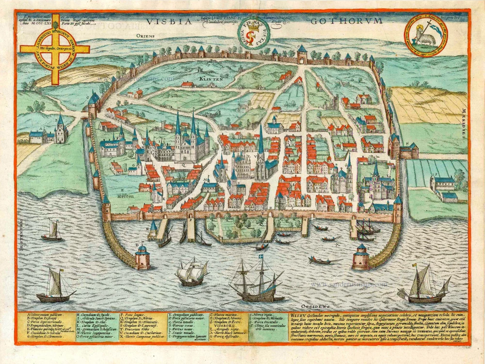
TRANSLATION OF CAPTION: In the name of Christian IV. King of Denmark, Norway, the Vandals and the Goths. COMMENTARY BY BRAUN: "On the Island of Gotland, where the Baltic Sea borders Sweden, Livonia and Prussia, in a region extremely well suited for cattle farming, for game, fish, marble quarrying and other vital necessities, lies the splendid city of Visby, famed throughout almost the whole of Christendom, whose large and ancient marble buildings still bear witness to its magnificence today. In 1288 it was granted its civic rights by King Magnus Ladulas of Sweden and with these the freedom to fortify the town with walls. [...] Right up to the present day, the inhabitants can still show visitors ten churches and four monasteries built in a single style of architecture. [...] It was in Visby harbour that the famous fish was caught, out of whose belly a child was cut, in the year of our Lord 1289." The view from the west shows Visby from the sea. In the town beyond the harbour, three churches stand out in particular: the Santa Maria Kyrka (Q), the convent church of Sankta Katarina (V) in the centre and on the right the Sankt Petri Kyrka (O). Only Sankta Maria (St Mary's) - the cathedral of the Visby diocese since 1572 - still stands today. Visby was continuously occupied from the Viking era onwards. In 1161 Henry the Lion granted the city a trading privilege that guaranteed legal security for commercial transactions. Around the middle of the 12th century Visby served as one of the first centres of the Hanseatic League and was called "Regina Maris", Queen of the Sea. In the 13th century, however, the city lost its leading position in Baltic trade to Lübeck. With the Treaty of Brömsebro in 1645 Visby became part of Sweden. (Taschen)
Braun G. & Hogenberg F. and the Civitates Orbis Terrarum.
The Civitates Orbis Terrarum, also known as the 'Braun & Hogenberg', is a six-volume town atlas and the most excellent book of town views and plans ever published: 363 engravings, sometimes beautifully coloured. It was one of the best-selling works in the last quarter of the 16th century. Georg Braun, a skilled writer, wrote the text accompanying the plans and views on the verso. Many plates were engraved after the original drawings of a professional artist, Joris Hoefnagel (1542-1600). The first volume was published in Latin in 1572 and the sixth in 1617. Frans Hogenberg, a talented engraver, created the tables for volumes I through IV, and Simon van den Neuwel made those for volumes V and VI. Other contributors were cartographers Daniel Freese and Heinrich Rantzau, who provided valuable geographical information. Works by Jacob van Deventer, Sebastian Münster, and Johannes Stumpf were also used as references. Translations appeared in German and French, making the atlas accessible to a broader audience.
Since its original publication of volume 1 in 1572, the Civitates Orbis Terrarum has left an indelible mark on the history of cartography. Seven more editions followed the first volume in 1575, 1577, 1582, 1588, 1593, 1599, and 1612. Vol.2, initially released in 1575, saw subsequent editions in 1597 and 1612. The subsequent volumes, each a treasure trove of historical insights, graced the world in 1581, 1588, 1593, 1599, and 1606. The German translation of the first volume, a testament to its widespread appeal, debuted in 1574, followed by the French edition in 1575.
Several printers were involved: Theodor Graminaeus, Heinrich von Aich, Gottfried von Kempen, Johannis Sinniger, Bertram Buchholtz, and Peter von Brachel, all of whom worked in Cologne.
Georg Braun (1541-1622)
Georg Braun, the author of the text accompanying the plans and views in the Civitates Orbis Terrarum, was born in Cologne in 1541. After his studies in Cologne, he entered the Jesuit Order as a novice, indicating his commitment to learning and intellectual pursuits. In 1561, he obtained his bachelor's degree; in 1562, he received his Magister Artium, further demonstrating his academic achievements. Although he left the Jesuit Order, he continued his studies in theology, gaining a licentiate in theology. His theological background likely influenced the content and tone of the text in the Civitates Orbis Terrarum, adding a unique perspective to the work.
Frans Hogenberg (1535-1590)
Frans Hogenberg was a Flemish and German painter, engraver, and mapmaker. He was born in Mechelen as the son of Nicolaas Hogenberg.
By the end of the 1560s, Frans Hogenberg was employed upon Abraham Ortelius's Theatrum Orbis Terrarum, published in 1570; he is named an engraver of numerous maps. In 1568, he was banned from Antwerp by the Duke of Alva and travelled to London, where he stayed a few years before emigrating to Cologne. He immediately embarked on his two most important works, the Civitates, published in 1572 and the Geschichtsblätter, which appeared in several series from 1569 until about 1587.
Thanks to large-scale projects like the Geschichtsblätter and the Civitates, Hogenberg's social circumstances improved with each passing year. He died as a wealthy man in Cologne in 1590.
Visbia Gothorum.
Item Number: 27635 Authenticity Guarantee
Category: Antique maps > Europe > Northern Europe
Old, antique bird's-eye view plan of Visby on Gotland, by Georg Braun and Frans Hogenberg.
Date of the first edition: 1596
Date of this map: 1600
Copper engraving, printed on paper.
Size (not including margins): 36.5 x 49cm (14.2 x 19.1 inches)
Verso text: Latin
Condition: Excellent, superb old colour.
Condition Rating: A+
From: Civitates Orbis Terrarum, ... Part 5. Köln, Bertram Buchholtz, 1600.
TRANSLATION OF CAPTION: In the name of Christian IV. King of Denmark, Norway, the Vandals and the Goths. COMMENTARY BY BRAUN: "On the Island of Gotland, where the Baltic Sea borders Sweden, Livonia and Prussia, in a region extremely well suited for cattle farming, for game, fish, marble quarrying and other vital necessities, lies the splendid city of Visby, famed throughout almost the whole of Christendom, whose large and ancient marble buildings still bear witness to its magnificence today. In 1288 it was granted its civic rights by King Magnus Ladulas of Sweden and with these the freedom to fortify the town with walls. [...] Right up to the present day, the inhabitants can still show visitors ten churches and four monasteries built in a single style of architecture. [...] It was in Visby harbour that the famous fish was caught, out of whose belly a child was cut, in the year of our Lord 1289." The view from the west shows Visby from the sea. In the town beyond the harbour, three churches stand out in particular: the Santa Maria Kyrka (Q), the convent church of Sankta Katarina (V) in the centre and on the right the Sankt Petri Kyrka (O). Only Sankta Maria (St Mary's) - the cathedral of the Visby diocese since 1572 - still stands today. Visby was continuously occupied from the Viking era onwards. In 1161 Henry the Lion granted the city a trading privilege that guaranteed legal security for commercial transactions. Around the middle of the 12th century Visby served as one of the first centres of the Hanseatic League and was called "Regina Maris", Queen of the Sea. In the 13th century, however, the city lost its leading position in Baltic trade to Lübeck. With the Treaty of Brömsebro in 1645 Visby became part of Sweden. (Taschen)
Braun G. & Hogenberg F. and the Civitates Orbis Terrarum.
The Civitates Orbis Terrarum, also known as the 'Braun & Hogenberg', is a six-volume town atlas and the most excellent book of town views and plans ever published: 363 engravings, sometimes beautifully coloured. It was one of the best-selling works in the last quarter of the 16th century. Georg Braun, a skilled writer, wrote the text accompanying the plans and views on the verso. Many plates were engraved after the original drawings of a professional artist, Joris Hoefnagel (1542-1600). The first volume was published in Latin in 1572 and the sixth in 1617. Frans Hogenberg, a talented engraver, created the tables for volumes I through IV, and Simon van den Neuwel made those for volumes V and VI. Other contributors were cartographers Daniel Freese and Heinrich Rantzau, who provided valuable geographical information. Works by Jacob van Deventer, Sebastian Münster, and Johannes Stumpf were also used as references. Translations appeared in German and French, making the atlas accessible to a broader audience.
Since its original publication of volume 1 in 1572, the Civitates Orbis Terrarum has left an indelible mark on the history of cartography. Seven more editions followed the first volume in 1575, 1577, 1582, 1588, 1593, 1599, and 1612. Vol.2, initially released in 1575, saw subsequent editions in 1597 and 1612. The subsequent volumes, each a treasure trove of historical insights, graced the world in 1581, 1588, 1593, 1599, and 1606. The German translation of the first volume, a testament to its widespread appeal, debuted in 1574, followed by the French edition in 1575.
Several printers were involved: Theodor Graminaeus, Heinrich von Aich, Gottfried von Kempen, Johannis Sinniger, Bertram Buchholtz, and Peter von Brachel, all of whom worked in Cologne.
Georg Braun (1541-1622)
Georg Braun, the author of the text accompanying the plans and views in the Civitates Orbis Terrarum, was born in Cologne in 1541. After his studies in Cologne, he entered the Jesuit Order as a novice, indicating his commitment to learning and intellectual pursuits. In 1561, he obtained his bachelor's degree; in 1562, he received his Magister Artium, further demonstrating his academic achievements. Although he left the Jesuit Order, he continued his studies in theology, gaining a licentiate in theology. His theological background likely influenced the content and tone of the text in the Civitates Orbis Terrarum, adding a unique perspective to the work.
Frans Hogenberg (1535-1590)
Frans Hogenberg was a Flemish and German painter, engraver, and mapmaker. He was born in Mechelen as the son of Nicolaas Hogenberg.
By the end of the 1560s, Frans Hogenberg was employed upon Abraham Ortelius's Theatrum Orbis Terrarum, published in 1570; he is named an engraver of numerous maps. In 1568, he was banned from Antwerp by the Duke of Alva and travelled to London, where he stayed a few years before emigrating to Cologne. He immediately embarked on his two most important works, the Civitates, published in 1572 and the Geschichtsblätter, which appeared in several series from 1569 until about 1587.
Thanks to large-scale projects like the Geschichtsblätter and the Civitates, Hogenberg's social circumstances improved with each passing year. He died as a wealthy man in Cologne in 1590.