Lebrija & Settenil de las Bodegas by Braun & Hogenberg. 1599


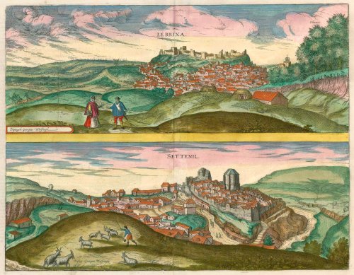


LEBRIJA
COMMENTARY BY BRAUN: "Lebrija is a charmingly situated town with a very old castle surrounded by farmland. Lebrija possesses its good name for this reason, above all things, for its delicious oils that are sent from here to India. In addition, various sorts of earthenware are produced here, and indeed large ones, called enagias, but also numerous small ones, called otigias, and in them, the oil is sent to the ends of the earth."
At the foot of a vast, ruined castle lies the Andalusian town of Lebrija, nestling in a hilly countryside. The lateral view from the northwest depicts a jumble of tightly packed houses, to the right of which the tower of the church of Santa Maria de la Oliva, once a mosque, can be made out just above some olive trees. On the hill in the foreground lie two enormous clay jugs used to hold olive oil. The city's founding goes back to the Phoenicians, despite a myth claiming that the god Bacchus was its founder. Nebrissa Veneria under the Romans, Lebrija fell under Moorish rule in the early 8th century but was won back by the Castilian king in 1249, during the Reconquista.
SETENIL DE LAS BODEGAS
COMMENTARY BY BRAUN: "Setenil is a Spanish town on a mountain with a wonderful location on the road leading from Jerez de la Frontera to Malaga. It has more houses in underground caves, hewn into the rock, than houses rising above the ground. As usual in the mountains, its farmland is hard and full of stones so that it can't be tilled with the plough; instead, the inhabitants keep all kinds of animals."
Setenil de las Bodegas is an Andalusian mountain village directly built into the cliffs hollowed out by the River Guadalporcun. The main road, called the "cave road", runs up the mountain through a small gorge in the centre. Two buildings rise above the sea of roofs; in the centre, the ruin of a Moorish castle from the 12th century and, further right, the massive Gothic parish church. The name Setenil derives from the Latin septem nihil and refers to the fact that the Moors were conquered in 1485 after as many as seven unsuccessful attempts. Today the town with 3,000 inhabitants lies on the popular Pueblos Blanchos ("White Villages") tourist route.
Braun G. & Hogenberg F. and the Civitates Orbis Terrarum.
The Civitates Orbis Terrarum, also known as the 'Braun & Hogenberg', is a six-volume town atlas and the most excellent book of town views and plans ever published: 363 engravings, sometimes beautifully coloured. It was one of the best-selling works in the last quarter of the 16th century. Georg Braun, a skilled writer, wrote the text accompanying the plans and views on the verso. Many plates were engraved after the original drawings of a professional artist, Joris Hoefnagel (1542-1600). The first volume was published in Latin in 1572 and the sixth in 1617. Frans Hogenberg, a talented engraver, created the tables for volumes I through IV, and Simon van den Neuwel made those for volumes V and VI. Other contributors were cartographers Daniel Freese and Heinrich Rantzau, who provided valuable geographical information. Works by Jacob van Deventer, Sebastian Münster, and Johannes Stumpf were also used as references. Translations appeared in German and French, making the atlas accessible to a broader audience.
Since its original publication of volume 1 in 1572, the Civitates Orbis Terrarum has left an indelible mark on the history of cartography. Seven more editions followed the first volume in 1575, 1577, 1582, 1588, 1593, 1599, and 1612. Vol.2, initially released in 1575, saw subsequent editions in 1597 and 1612. The subsequent volumes, each a treasure trove of historical insights, graced the world in 1581, 1588, 1593, 1599, and 1606. The German translation of the first volume, a testament to its widespread appeal, debuted in 1574, followed by the French edition in 1575.
Several printers were involved: Theodor Graminaeus, Heinrich von Aich, Gottfried von Kempen, Johannis Sinniger, Bertram Buchholtz, and Peter von Brachel, all of whom worked in Cologne.
Georg Braun (1541-1622)
Georg Braun, the author of the text accompanying the plans and views in the Civitates Orbis Terrarum, was born in Cologne in 1541. After his studies in Cologne, he entered the Jesuit Order as a novice, indicating his commitment to learning and intellectual pursuits. In 1561, he obtained his bachelor's degree; in 1562, he received his Magister Artium, further demonstrating his academic achievements. Although he left the Jesuit Order, he continued his studies in theology, gaining a licentiate in theology. His theological background likely influenced the content and tone of the text in the Civitates Orbis Terrarum, adding a unique perspective to the work.
Frans Hogenberg (1535-1590)
Frans Hogenberg was a Flemish and German painter, engraver, and mapmaker. He was born in Mechelen as the son of Nicolaas Hogenberg.
By the end of the 1560s, Frans Hogenberg was employed upon Abraham Ortelius's Theatrum Orbis Terrarum, published in 1570; he is named an engraver of numerous maps. In 1568, he was banned from Antwerp by the Duke of Alva and travelled to London, where he stayed a few years before emigrating to Cologne. He immediately embarked on his two most important works, the Civitates, published in 1572 and the Geschichtsblätter, which appeared in several series from 1569 until about 1587.
Thanks to large-scale projects like the Geschichtsblätter and the Civitates, Hogenberg's social circumstances improved with each passing year. He died as a wealthy man in Cologne in 1590.
Le Brixa [on sheet with] Settenil.
Item Number: 22188 Authenticity Guarantee
Category: Antique maps > Europe > Spain and Portugal
Old map with two bird's-eye views on one sheet: Lebrija & Settenil de las Bodegas, by Braun and Hogenberg.
Engraved after Georg Hoefnagel, who made the drawings in 1564.
Title: Le Brixa [on sheet with] Settenil.
Date of the first edition: 1581.
Date of this map: 1599.
Copper engraving, printed on paper.
Size (not including margins): 320 x 410mm (12.6 x 16.14 inches).
Verso: Latin text.
Condition: Excellent, superb old colour.
Condition Rating: A+.
From: Civitates Orbis Terrarum. Liber tertius. Köln, Bertram Buchholtz, 1599. (Koeman, B&H3)
LEBRIJA
COMMENTARY BY BRAUN: "Lebrija is a charmingly situated town with a very old castle surrounded by farmland. Lebrija possesses its good name for this reason, above all things, for its delicious oils that are sent from here to India. In addition, various sorts of earthenware are produced here, and indeed large ones, called enagias, but also numerous small ones, called otigias, and in them, the oil is sent to the ends of the earth."
At the foot of a vast, ruined castle lies the Andalusian town of Lebrija, nestling in a hilly countryside. The lateral view from the northwest depicts a jumble of tightly packed houses, to the right of which the tower of the church of Santa Maria de la Oliva, once a mosque, can be made out just above some olive trees. On the hill in the foreground lie two enormous clay jugs used to hold olive oil. The city's founding goes back to the Phoenicians, despite a myth claiming that the god Bacchus was its founder. Nebrissa Veneria under the Romans, Lebrija fell under Moorish rule in the early 8th century but was won back by the Castilian king in 1249, during the Reconquista.
SETENIL DE LAS BODEGAS
COMMENTARY BY BRAUN: "Setenil is a Spanish town on a mountain with a wonderful location on the road leading from Jerez de la Frontera to Malaga. It has more houses in underground caves, hewn into the rock, than houses rising above the ground. As usual in the mountains, its farmland is hard and full of stones so that it can't be tilled with the plough; instead, the inhabitants keep all kinds of animals."
Setenil de las Bodegas is an Andalusian mountain village directly built into the cliffs hollowed out by the River Guadalporcun. The main road, called the "cave road", runs up the mountain through a small gorge in the centre. Two buildings rise above the sea of roofs; in the centre, the ruin of a Moorish castle from the 12th century and, further right, the massive Gothic parish church. The name Setenil derives from the Latin septem nihil and refers to the fact that the Moors were conquered in 1485 after as many as seven unsuccessful attempts. Today the town with 3,000 inhabitants lies on the popular Pueblos Blanchos ("White Villages") tourist route.
Braun G. & Hogenberg F. and the Civitates Orbis Terrarum.
The Civitates Orbis Terrarum, also known as the 'Braun & Hogenberg', is a six-volume town atlas and the most excellent book of town views and plans ever published: 363 engravings, sometimes beautifully coloured. It was one of the best-selling works in the last quarter of the 16th century. Georg Braun, a skilled writer, wrote the text accompanying the plans and views on the verso. Many plates were engraved after the original drawings of a professional artist, Joris Hoefnagel (1542-1600). The first volume was published in Latin in 1572 and the sixth in 1617. Frans Hogenberg, a talented engraver, created the tables for volumes I through IV, and Simon van den Neuwel made those for volumes V and VI. Other contributors were cartographers Daniel Freese and Heinrich Rantzau, who provided valuable geographical information. Works by Jacob van Deventer, Sebastian Münster, and Johannes Stumpf were also used as references. Translations appeared in German and French, making the atlas accessible to a broader audience.
Since its original publication of volume 1 in 1572, the Civitates Orbis Terrarum has left an indelible mark on the history of cartography. Seven more editions followed the first volume in 1575, 1577, 1582, 1588, 1593, 1599, and 1612. Vol.2, initially released in 1575, saw subsequent editions in 1597 and 1612. The subsequent volumes, each a treasure trove of historical insights, graced the world in 1581, 1588, 1593, 1599, and 1606. The German translation of the first volume, a testament to its widespread appeal, debuted in 1574, followed by the French edition in 1575.
Several printers were involved: Theodor Graminaeus, Heinrich von Aich, Gottfried von Kempen, Johannis Sinniger, Bertram Buchholtz, and Peter von Brachel, all of whom worked in Cologne.
Georg Braun (1541-1622)
Georg Braun, the author of the text accompanying the plans and views in the Civitates Orbis Terrarum, was born in Cologne in 1541. After his studies in Cologne, he entered the Jesuit Order as a novice, indicating his commitment to learning and intellectual pursuits. In 1561, he obtained his bachelor's degree; in 1562, he received his Magister Artium, further demonstrating his academic achievements. Although he left the Jesuit Order, he continued his studies in theology, gaining a licentiate in theology. His theological background likely influenced the content and tone of the text in the Civitates Orbis Terrarum, adding a unique perspective to the work.
Frans Hogenberg (1535-1590)
Frans Hogenberg was a Flemish and German painter, engraver, and mapmaker. He was born in Mechelen as the son of Nicolaas Hogenberg.
By the end of the 1560s, Frans Hogenberg was employed upon Abraham Ortelius's Theatrum Orbis Terrarum, published in 1570; he is named an engraver of numerous maps. In 1568, he was banned from Antwerp by the Duke of Alva and travelled to London, where he stayed a few years before emigrating to Cologne. He immediately embarked on his two most important works, the Civitates, published in 1572 and the Geschichtsblätter, which appeared in several series from 1569 until about 1587.
Thanks to large-scale projects like the Geschichtsblätter and the Civitates, Hogenberg's social circumstances improved with each passing year. He died as a wealthy man in Cologne in 1590.