
Iberian Peninsula (Spain & Portugal) by N. Sanson, so-called published by Hubert Jaillot. (Pirated edition by Pierre Mortier). 1692

Alexis-Hubert JAILLOT (1632-1712)
A.-H. Jaillot first started as a sculptor. In 1664 he married Jeanne Berey, daughter of the publisher and dealer of prints Nicolas I Berey. Jaillot soon rushed into the print business due to his father-in-law's deaths in 1665 and his brother-in-law in 1667. In 1668, A.-H. Jaillot and his wife acquire the Berey fund's geographical part, which consists of globes, maps, city views and atlases. He becomes the tenant of his father-in-law's shop, Aux Deux Globes, which he buys two years later.
Jaillot enters into an agreement with Guillaume Sanson to publish his maps that will form his Atlas Nouveau's embryo. Sanson undertakes to obtain the privilege for his maps for twenty years and to cede it to Jaillot, as is the custom. Jaillot, for its part, takes care of the engraving, printing and sale of the maps. He engages engravers, François Caumartin and Louis Cordier, to engrave his maps.
A conflict arises between Jaillot and Sanson, and in 1674 it comes to a lawsuit. In 1677 they came back to an agreement.
The Atlas Nouveau first appeared in 1681 and brought great prosperity to his publisher. Jaillot owes him his title of the geographer to the king, awarded on July 20, 1686. He continues to issue maps and signs more and more himself. In 1695, he published the Atlas Français, two-thirds of which are his maps and only one third by Sanson.
A.H. Jaillot dies in 1712 and leaves a vast trading fund.
Covens & Mortier. A Map Publishing House in Amsterdam. 1721-1866.
For almost two centuries, the Amsterdam firm of Covens & Mortier was the most significant and crucial Dutch publishing house in commercial cartography. In terms of quantity, it was the biggest contemporary map-trading house worldwide, distributing innumerable maps, atlases, globes, and books.
Pieter (Pierre) Mortier (Leiden, 1661 – Amsterdam, 1711)
Nothing is known about the youth of Pieter Mortier. He studied in Paris from 1681 to approximately 1685. He must have come into contact with French 'libraires' and learned the bookselling trade there. In 1685, he returned to Amsterdam and opened a small bookshop. He joined the Book, Art Sellers' and Printers' Guild the same year.
Pieter sold books in Dutch and foreign languages but also published books himself, usually in French. His business flourished so much that in 1688, he was forced to rent another house on the Vijgendam.
Pieter Mortier's first privilege for maps was granted by the States of Holland and West Friesland on September 15, 1690. It refers to Sanson's maps, which he 'is printing and correcting with great pains and care'.
Pieter began publishing maps and atlases on a large scale. By the beginning of the 18th century, he had become so wealthy that he could purchase three houses in Amsterdam: the Beurssluis, on the Vijgendam, and the Heremietensteeg. He rebuilt the Vijgendam house into a large, prestigious structure that would serve for over a century as a shop, business, and residential structure for Covens & Mortier's publishing house.
He died on February 13, 1711, after a brief illness. The company continued under the management of Pieter's widow, Amelia' s-Gravesande.
After she died in 1719, her son, Cornelis, took over the management for a few years.
On November 20, 1721, a company was founded by Cornelis Mortier and Johannes Covens I. The latter was married the same year to Cornelis's sister. From that year on, the name of :
Covens & Mortier.
Their firm would see a massive expansion in the next 140 years. In 1732, the heirs sold the property to their brother Cornelis and his partner Covens. Their main competitors were Reinier & Josua Ottens and Gerard Valck & Petrus Schenck. After the death of Johannes Covens I (1774), his son Johannes Covens II (1722-1794) entered the business. In 1778, Johannes added a new company name :
J. Covens & Son.
Johannes Covens II was succeeded by his son Cornelis Covens (1764-1825), who, in turn, brought Peter Mortier IV, the great-grandson of Petrus Mortier I, into the business. The name was from 1794 to 1866:
Mortier, Covens & Son.
The last Covens in the series was Cornelis Johannes Covens (1806-1880).
Covens & Mortier had a large stock of atlases and maps, including Delisle, Jaillot, Johannes Janssonius, Sanson, and Claes Jansz. Visscher, Nicolaas Visscher, and Frederik de Wit. For decades, the press produced an impressive number of atlases.
L'Espagne divisée en tous ses Royaumes et Principautés Suivant qu'ils sont Compris sous les Couronnes de Castille et d'Aragon,
Item Number: 31437 Authenticity Guarantee
Category: Antique maps > Europe > Spain and Portugal
Iberian Peninsula (Spain & Portugal) by N. Sanson, so-called published by Hubert Jaillot. (Pirated edition by Pierre Mortier).
Title: L'Espagne divisée en tous ses Royaumes et Principautés Suivant qu'ils sont Compris sous les Couronnes de Castille et d'Aragon,
Possedées par Le Roy Catholique: et sous la Couronne de Portugal poßedée par le Roy de Portugal.
Tiré de plusieurs Memoires les plus recents.
Par le Sr. Sanson Geographe du Roy.
A Paris Chez H. Iaillot joignant les grands Augustins, aux deux Globes.
Avec Privilege de sa Majesté pour 20 ans 1692.
Cartographer: N. Sanson.
Date of the first edition: 1672.
Date of this map: 1692.
Date on map: 1692.
Copper engraving, printed from two plates on paper, joined.
Image size: 580 x 875mm (22¾ x 34½ inches).
Sheet size: 625 x 935mm (24½ x 36¾ inches).
Verso: Blank.
Condition: Original coloured in outline, excellent.
Condition Rating: A+.
From: Atlas nouveau contenant toutes les parties du monde ... Paris, H. Jaillot, [1692] (Pastoureau, Jaillot I-D) = Dutch pirated edition by Pierre Mortier.
Alexis-Hubert JAILLOT (1632-1712)
A.-H. Jaillot first started as a sculptor. In 1664 he married Jeanne Berey, daughter of the publisher and dealer of prints Nicolas I Berey. Jaillot soon rushed into the print business due to his father-in-law's deaths in 1665 and his brother-in-law in 1667. In 1668, A.-H. Jaillot and his wife acquire the Berey fund's geographical part, which consists of globes, maps, city views and atlases. He becomes the tenant of his father-in-law's shop, Aux Deux Globes, which he buys two years later.
Jaillot enters into an agreement with Guillaume Sanson to publish his maps that will form his Atlas Nouveau's embryo. Sanson undertakes to obtain the privilege for his maps for twenty years and to cede it to Jaillot, as is the custom. Jaillot, for its part, takes care of the engraving, printing and sale of the maps. He engages engravers, François Caumartin and Louis Cordier, to engrave his maps.
A conflict arises between Jaillot and Sanson, and in 1674 it comes to a lawsuit. In 1677 they came back to an agreement.
The Atlas Nouveau first appeared in 1681 and brought great prosperity to his publisher. Jaillot owes him his title of the geographer to the king, awarded on July 20, 1686. He continues to issue maps and signs more and more himself. In 1695, he published the Atlas Français, two-thirds of which are his maps and only one third by Sanson.
A.H. Jaillot dies in 1712 and leaves a vast trading fund.
Covens & Mortier. A Map Publishing House in Amsterdam. 1721-1866.
For almost two centuries, the Amsterdam firm of Covens & Mortier was the most significant and crucial Dutch publishing house in commercial cartography. In terms of quantity, it was the biggest contemporary map-trading house worldwide, distributing innumerable maps, atlases, globes, and books.
Pieter (Pierre) Mortier (Leiden, 1661 – Amsterdam, 1711)
Nothing is known about the youth of Pieter Mortier. He studied in Paris from 1681 to approximately 1685. He must have come into contact with French 'libraires' and learned the bookselling trade there. In 1685, he returned to Amsterdam and opened a small bookshop. He joined the Book, Art Sellers' and Printers' Guild the same year.
Pieter sold books in Dutch and foreign languages but also published books himself, usually in French. His business flourished so much that in 1688, he was forced to rent another house on the Vijgendam.
Pieter Mortier's first privilege for maps was granted by the States of Holland and West Friesland on September 15, 1690. It refers to Sanson's maps, which he 'is printing and correcting with great pains and care'.
Pieter began publishing maps and atlases on a large scale. By the beginning of the 18th century, he had become so wealthy that he could purchase three houses in Amsterdam: the Beurssluis, on the Vijgendam, and the Heremietensteeg. He rebuilt the Vijgendam house into a large, prestigious structure that would serve for over a century as a shop, business, and residential structure for Covens & Mortier's publishing house.
He died on February 13, 1711, after a brief illness. The company continued under the management of Pieter's widow, Amelia' s-Gravesande.
After she died in 1719, her son, Cornelis, took over the management for a few years.
On November 20, 1721, a company was founded by Cornelis Mortier and Johannes Covens I. The latter was married the same year to Cornelis's sister. From that year on, the name of :
Covens & Mortier.
Their firm would see a massive expansion in the next 140 years. In 1732, the heirs sold the property to their brother Cornelis and his partner Covens. Their main competitors were Reinier & Josua Ottens and Gerard Valck & Petrus Schenck. After the death of Johannes Covens I (1774), his son Johannes Covens II (1722-1794) entered the business. In 1778, Johannes added a new company name :
J. Covens & Son.
Johannes Covens II was succeeded by his son Cornelis Covens (1764-1825), who, in turn, brought Peter Mortier IV, the great-grandson of Petrus Mortier I, into the business. The name was from 1794 to 1866:
Mortier, Covens & Son.
The last Covens in the series was Cornelis Johannes Covens (1806-1880).
Covens & Mortier had a large stock of atlases and maps, including Delisle, Jaillot, Johannes Janssonius, Sanson, and Claes Jansz. Visscher, Nicolaas Visscher, and Frederik de Wit. For decades, the press produced an impressive number of atlases.
Related items

Regni Hispaniae Post Omnium Editiones Locuplessima Descriptio. 1598
Iberian Peninsula (Portugal & Spain), by Abraham Ortelius.
[Item number: 2568]

Regni Hispaniae Post Omnium Editiones Locuplessima Descriptio. 1601
Iberian Peninsula (Spain & Portugal), by A. Ortelius.
[Item number: 5727]

Hispania III Nova Tabula. 1542
Iberian Peninsula (Spain & Portugal), by Sebastian Münster.
[Item number: 14923]

Hispaniae Veteris Descriptio. 1641
Spain (antique), by Johannes Janssonius.
[Item number: 26327]

Typus Hispaniae ab Hesselo Gerardo delineata et juxta annotationes Doctiss. Dni. Don Andreae d'Almada S. Theologiae Publici Professoris apud Coimbricenses emendatus M.DC.XXXI. 1641
The Iberian Peninsula (Spain & Portugal), by Henricus Hondius.
[Item number: 26328]

Tabu. Nova Hispaniae. 1535
Iberian Peninsula (Spain and Portugal) by Lorenz Fries.
[Item number: 26762]

[No title] - [On verso:] Tabula .II. Europae. 1525
Spain & Portugal, by Spain & Portugal.
[Item number: 27956]

Hispania Antiqua in tres praecipuas partes scilicet Tarraconensem, Lusitaniam, et Baeticam, 1776-79
Ancient Iberian Peninsula (Spain & Portugal), by Francesco Santini, after Nicolas Sanson & Sr. Robert de Vaugondy.
[Item number: 28106]
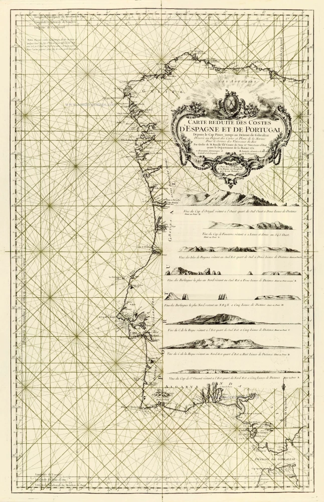
Carte Réduite des Costes d'Espagne et de Portugal. 1756-1770
Spain - Portugal, by J.N. Bellin.
[Item number: 28124]

Very important map.
Hispaniae Descriptio. 1559
Iberian Peninsula (Spain & Portugal) by Vincenzo Luchini.
[Item number: 28151]

Nova Hispaniae Descriptio. 1632
Spain by Joannes Janssonius.
[Item number: 28205]

Nova et accurata Tabula Hispaniae Praecipuis Urbibus Vestitu Insignibus et Antiquitatibus exornata. c. 1640
Spain & Portugal (Iberian Peninsula) by Cornelis Danckerts.
[Item number: 28211]

Novissima et Accuratissima Regnorum Hispaniae et Portugalliae. c. 1715
Iberian Peninsula (Spain & Portugal) by Covens & Mortier.
[Item number: 28238]

Rare!
Nova Regni Hispaniae Descriptio, de novo multis in locis aucta et emendata. 1605
Spain by Willem Blaeu
[Item number: 28367]

Totius Regnorum Hispaniae et Portugalliae. 1680
Iberian Peninsula (Spain & Portugal) by Frederick de Wit.
[Item number: 28604]

Les Estats de la Couronne de Castille, dans les Parties plus Septentrionales de l'Espagne: 1652
Northern Spain by Nicolas Sanson.
[Item number: 29660]

Les estats de la Couronne de Castille, dans les Parties plus Meridionales de l'Espagne: 1652
Southern Spain by Nicolas Sanson.
[Item number: 29661]

Hispaniae Antiquae Tabulae. 1652
Spain by Nicolas Sanson.
[Item number: 29694]

*** Rare first state. ***
Antiquorum Hispaniae Episcopatuum Geographica Descriptio. 1640
Ancient Iberian Peninsula (Spain & Portugal) by Melchior Tavernier.
[Item number: 30043]

Regnorum Hispaniae nova descriptio. 1643
Iberian Peninsula (Spain & Portugal) by Willem Blaeu.
[Item number: 32155]

Regnorum Hispaniae et Portugalliae Tabula Generalis. c. 1720
Iberian Peninsula (Spain & Portugal) by J.B. Homann.
[Item number: 32160]

Accuratissima Totius Regni Hispaniae Tabula. c. 1680
Iberian Peninsula (Spain & Portugal) by Justus Danckerts
[Item number: 32462]

From the first Dutch folio printed sea atlas
Pascaart Vande Custen Van Andaluzia, Portugal, Gallissien, Biscajen en een gedeelte van Vranckryck ... | Tabula Hydrographica de Oris Andalusiae, Portugalliae, Galliciae, Biscaje et Aliqua Galliae parte ... 1650
Spanish coast by J. Janssonius.
[Item number: 32626]

Hispaniae Nova Describtio, de integro multis inlocis, secundum hydrographicas, desc. emendata. 1613
Iberian Peninsula (Spain & Portugal), by J. Hondius.
[Item number: 32703]

La Spagna. 1677
Iberian Peninsula (Spain & Portugal), by Guillaume & Nicolas Sanson, published by Giovanni Giacomo de Rossi.
[Item number: 32908]