
Iberian Peninsula (Portugal & Spain), by Abraham Ortelius. 1598


Abraham Ortelius (1527-1598)
The maker of the 'first atlas', the Theatrum Orbis Terrarum (1570), was born on 4 April 1527 into an old Antwerp family. He learned Latin and studied Greek and mathematics.
Abraham and his sisters, Anne and Elizabeth, took up map colouring. Ortelius was admitted to the Guild of St. Luke as an "illuminator of maps." In addition to colouring maps, Ortelius was a dealer in antiques, coins, maps, and books, and the book and map trade gradually became his primary occupation.
Business went well because his means allowed him to amass an extensive collection of medals, coins, and antiques, as well as a library of many volumes. In addition, he travelled extensively, visited Italy and France, made contacts with scholars and editors everywhere, and maintained extensive correspondence with them.
In 1564, he published his first map, a large and ambitious world wall map. The inspiration for this map may well have been Gastaldi's large world map. In 1565, he published a map of Egypt and a map of the Holy Land; a large map of Asia followed.
In 1568, the production of individual maps for his atlas Theatrum Orbis Terrarum was already in full swing. He completed the atlas in 1569, and in May 1570, it was available for sale. It was one of the most expensive books ever published.
This first edition contained seventy maps on fifty-three sheets. Franciscus Hogenberg engraved the maps.
Later editions included Additamenta (additions), resulting in Ortelius' historical atlas, the Parergon, which is mainly bound together with the atlas. The Parergon can be considered a truly original work by Ortelius, who drew the maps based on his research.
The importance of the Theatrum Orbis Terrarum for geographical knowledge in the last quarter of the sixteenth century is difficult to overemphasise. Nothing was like it until Mercator's atlas appeared twenty-five years later. Demand for the Theatrum was remarkable. Some 24 editions appeared during Ortelius's lifetime, and another 10 after he died in 1598. Editions were published in Dutch, German, French, Spanish, English, and Italian. The number of map sheets grew from 53 in 1570 to 167 in the last edition in 1612.
In 1577, engraver Philip Galle and poet-translator Pieter Heyns published the first pocket-sized edition of the Theatrum, the Epitome. The work was trendy. Over thirty editions of this Epitome were published in different languages.
Ortelius is also remembered for an early idea resembling continental drift: he suggested that the Americas, Europe, and Africa may once have been joined together before separating over time. His work helped shape the development of modern geography and mapmaking.
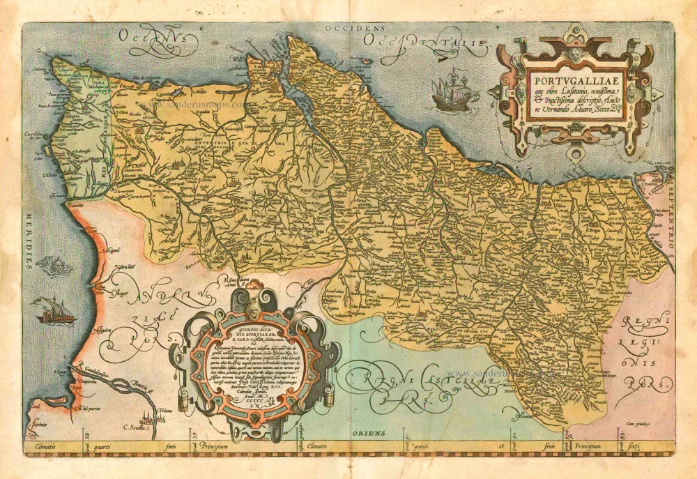
Regni Hispaniae Post Omnium Editiones Locuplessima Descriptio.
Item Number: 2568 Authenticity Guarantee
Category: Antique maps > Europe > Spain and Portugal
Old antique map of Iberian Peninsula (Portugal & Spain) by A. Ortelius.
Title: Regni Hispaniae Post Omnium Editiones Locuplessima Descriptio.
Date of the first edition: 1570.
Date of this map: 1598.
Copper engraving, printed on paper.
Size (not including margins): 382 x 500mm (15.04 x 19.69 inches).
Verso: Dutch text.
Condition: Original coloured, lower centrefold split reinforced.
Condition Rating: A.
From: Theatrum Orbis Terrarum (Dutch edition. Amsterdam, Cornelis Claesz., 1598), Ghedruckt voor Abraham Ortelius, Anno MDXCVIII. (Van der Krogt 3, 31:121)
Abraham Ortelius (1527-1598)
The maker of the 'first atlas', the Theatrum Orbis Terrarum (1570), was born on 4 April 1527 into an old Antwerp family. He learned Latin and studied Greek and mathematics.
Abraham and his sisters, Anne and Elizabeth, took up map colouring. Ortelius was admitted to the Guild of St. Luke as an "illuminator of maps." In addition to colouring maps, Ortelius was a dealer in antiques, coins, maps, and books, and the book and map trade gradually became his primary occupation.
Business went well because his means allowed him to amass an extensive collection of medals, coins, and antiques, as well as a library of many volumes. In addition, he travelled extensively, visited Italy and France, made contacts with scholars and editors everywhere, and maintained extensive correspondence with them.
In 1564, he published his first map, a large and ambitious world wall map. The inspiration for this map may well have been Gastaldi's large world map. In 1565, he published a map of Egypt and a map of the Holy Land; a large map of Asia followed.
In 1568, the production of individual maps for his atlas Theatrum Orbis Terrarum was already in full swing. He completed the atlas in 1569, and in May 1570, it was available for sale. It was one of the most expensive books ever published.
This first edition contained seventy maps on fifty-three sheets. Franciscus Hogenberg engraved the maps.
Later editions included Additamenta (additions), resulting in Ortelius' historical atlas, the Parergon, which is mainly bound together with the atlas. The Parergon can be considered a truly original work by Ortelius, who drew the maps based on his research.
The importance of the Theatrum Orbis Terrarum for geographical knowledge in the last quarter of the sixteenth century is difficult to overemphasise. Nothing was like it until Mercator's atlas appeared twenty-five years later. Demand for the Theatrum was remarkable. Some 24 editions appeared during Ortelius's lifetime, and another 10 after he died in 1598. Editions were published in Dutch, German, French, Spanish, English, and Italian. The number of map sheets grew from 53 in 1570 to 167 in the last edition in 1612.
In 1577, engraver Philip Galle and poet-translator Pieter Heyns published the first pocket-sized edition of the Theatrum, the Epitome. The work was trendy. Over thirty editions of this Epitome were published in different languages.
Ortelius is also remembered for an early idea resembling continental drift: he suggested that the Americas, Europe, and Africa may once have been joined together before separating over time. His work helped shape the development of modern geography and mapmaking.
Related items

Regni Hispaniae Post Omnium Editiones Locuplessima Descriptio. 1601
Iberian Peninsula (Spain & Portugal), by A. Ortelius.
[Item number: 5727]
Portugalliae que olim Lusitania, novissima & exactissima descriptio, ... 1601
Portugal by A. Ortelius.
[Item number: 5729]

Very rare!
Nova Regni Portugalliae et Algarbiae Descriptio ... c. 1690
Portugal by J. de Ram, published by F. De Wit.
[Item number: 13745]

Hispania III Nova Tabula. 1542
Iberian Peninsula (Spain & Portugal), by Sebastian Münster.
[Item number: 14923]

Hispaniae Nova Describtio, de integro multis inlocis, secundum hydrographicas, desc. emendata. 1623
Iberian Peninsula (Spain & Portugal), by J. Hondius.
[Item number: 24904]

Hispaniae Veteris Descriptio. 1641
Spain (antique), by Johannes Janssonius.
[Item number: 26327]

Typus Hispaniae ab Hesselo Gerardo delineata et juxta annotationes Doctiss. Dni. Don Andreae d'Almada S. Theologiae Publici Professoris apud Coimbricenses emendatus M.DC.XXXI. 1641
The Iberian Peninsula (Spain & Portugal), by Henricus Hondius.
[Item number: 26328]

Tabu. Nova Hispaniae. 1535
Iberian Peninsula (Spain and Portugal) by Lorenz Fries.
[Item number: 26762]

[No title] - [On verso:] Tabula .II. Europae. 1525
Spain & Portugal, by Spain & Portugal.
[Item number: 27956]

Very important map.
Hispaniae Descriptio. 1559
Iberian Peninsula (Spain & Portugal) by Vincenzo Luchini.
[Item number: 28151]

Nova Hispaniae Descriptio. 1632
Spain by Joannes Janssonius.
[Item number: 28205]

Nova et accurata Tabula Hispaniae Praecipuis Urbibus Vestitu Insignibus et Antiquitatibus exornata. c. 1640
Spain & Portugal (Iberian Peninsula) by Cornelis Danckerts.
[Item number: 28211]

Rare!
Nova Regni Hispaniae Descriptio, de novo multis in locis aucta et emendata. 1605
Spain by Willem Blaeu
[Item number: 28367]

Totius Regnorum Hispaniae et Portugalliae. 1680
Iberian Peninsula (Spain & Portugal) by Frederick de Wit.
[Item number: 28604]

Les Estats de la Couronne de Castille, dans les Parties plus Septentrionales de l'Espagne: 1652
Northern Spain by Nicolas Sanson.
[Item number: 29660]

Hispaniae Antiquae Tabulae. 1652
Spain by Nicolas Sanson.
[Item number: 29694]

Carte Generale d'Espagne et tous les Royaumes y compris. 1659
Iberian Peninsula (Spain & Portugal) by Nicolas Sanson.
[Item number: 29718]

Regni Hispaniae post omnium editiones locupleissima Descrptio. / Hispania. 1598
Iberian Peninsula (Spain & Portugal) by Abraham Ortelius.
[Item number: 29946]

*** Rare first state. ***
Antiquorum Hispaniae Episcopatuum Geographica Descriptio. 1640
Ancient Iberian Peninsula (Spain & Portugal) by Melchior Tavernier.
[Item number: 30043]

Parergon map
Hispaniae Veteris Descriptio. 1595
Iberian Peninsula by Abraham Ortelius.
[Item number: 30080]

Portugalliae que olim Lusitania, novissima et exactissima descriptio, c. 1610-1650
Portugal, by Jodocus Hondius.
[Item number: 30921]

L'Espagne divisée en tous ses Royaumes et Principautés Suivant qu'ils sont Compris sous les Couronnes de Castille et d'Aragon, 1692
Iberian Peninsula (Spain & Portugal) by N. Sanson, so-called published by Hubert Jaillot. (Pirated edition by Pierre Mortier).
[Item number: 31437]

Hispania. 1618
Iberian Peninsula (Spain & Portugal) by Petrus Bertius, published by Jodocus Hondius II.
[Item number: 31544]

Regnorum Hispaniae nova descriptio. 1643
Iberian Peninsula (Spain & Portugal) by Willem Blaeu.
[Item number: 32155]

Regnorum Hispaniae et Portugalliae Tabula Generalis. c. 1720
Iberian Peninsula (Spain & Portugal) by J.B. Homann.
[Item number: 32160]

Portugalliae et Algarbiae cumfinitimis Hispaniae Regnis: Castiliae, Legionis, Andalusiae, Extrematurae, Galliciae & Granatae Novissima Tabula c. 1720
Portugal & Brazil, by J.B. Homann.
[Item number: 32161]

From the first Dutch folio printed sea atlas
Pascaart Vande Custen Van Andaluzia, Portugal, Gallissien, Biscajen en een gedeelte van Vranckryck ... | Tabula Hydrographica de Oris Andalusiae, Portugalliae, Galliciae, Biscaje et Aliqua Galliae parte ... 1650
Spanish coast by J. Janssonius.
[Item number: 32626]