
Iberian Peninsula (Spain & Portugal) by Petrus Bertius, published by Jodocus Hondius II. 1618

Petrus Bertius (1565-1629)
Petrus Bertius, born at Beveren, Flanders, in 1565, was related to Pieter van den Keere (Kaerius) and Jodocus Hondius. Both famous cartographers were brothers-in-law of Petrus Bertius. As a refugee, he settled in Amsterdam, and after finishing his studies, he became a professor of mathematics and librarian at the University of Leiden. In 1618, he became a cosmographer and historiographer for Louis XIII of France. He lived in Paris, where he died in 1629.
Petrus Bertius's remarkable work ethic is evident in the numerous geographical and theological works he produced. His contributions to the works of Clüver and Herrera further solidified his reputation in geography.
His fame among geographers was established by his text in the pocket atlas Tabularum Geographicarum and by his edition of Ptolemy’s Geographia.
The origin of the Tabularum Geographicum lies in the well-known miniature atlas Caert thresoor, published by Barent Langenes in 1598 in Middelburg. Bertius engraved 169 maps for this small but attractive atlas, sold for the first time in 1599 by Cornelis Claesz in Amsterdam. In 1600, Claesz published the pocket atlas with a Latin text composed by Petrus Bertius. From then on, new editions, often enlarged with new maps, regularly appeared, subsequently published by Cornelis Claesz, Jodocus Hondius, Johannes Janssonius and ultimately, in 1649, by Claes Jansz. Visscher.
Koeman divides this series of pocketbooks into two atlases: The Caert-thresoor, published by Langenes and Claesz., with five editions between 1598 and 1609, and the Tabularum Geographicarum Contractarum by Petrus Bertius with ten editions between 1600 and 1650.
The Hondius Family
Jodocus Hondius the Elder (1563-1612)
Joost d’Hondt was born at Wakken (Flanders) in 1563. Two years later, his family settled in Ghent, where young Joost displayed an excellent gift for drawing and calligraphy. Through study and lessons, he developed his talents and became an engraver with a good reputation.
Due to the circumstances of the war, he moved to London in 1584, where he settled down as an engraver, instrument-maker, and map-maker. In 1587, he married Coletta van den Keere, sister of the well-known engraver Pieter van den Keere (Petrus Kaerius); some years earlier, his sister, Jacomina, had married Pieter van den Berghe (Petrus Montanus). Joost, who had Latinized his name to Jodocus Hondius, closely co-operated with his two brothers-in-law.
The political situation in the Northern Netherlands in 1593 was such that Jodocus seemed justified in establishing himself in Amsterdam, where many Antwerp printers, publishers, and engravers had gone. In this new centre of cartography, Jodocus Hondius set up his business “In de Wackere Hondt” (in the vigilant dog), this name being an allusion to his birthplace and name. He engraved many maps and published atlases and many other works, such as his continuation of Gerard Mercator’s Atlas.
He suddenly passed away in February 1612. The publishing firm of Jodocus Hondius was continued by his widow, later on, by his two sons, Jodocus Jr. and Henricus, and by his son-in-law, J. Janssonius.
Jodocus Hondius II (1594-1629) & Henricus Hondius (1597-1651)
After the father’s death, the widow and her seven children continued publishing the atlases under the name of Jodocus Hondius till 1620. The firm was reinforced by the very welcome help of Joannes Janssonius (1588-1664), who married 24-year-old Elisabeth Hondius in 1612. After 1619, Mercator’s Atlas was published under the name of Henricus Hondius.
One of the most dramatic events in the early history of commercial cartography in Amsterdam was the sale of Jodocus Hondius Jr.’s copper plates to Willem Jansz. Blaeu in 1629, the year of his death. At least 34 plates, from which Jodocus II had printed single-sheet maps for his benefit, passed into the hands of his great competitor. Immediately after that, his brother, Henricus, and Joannes Janssonius ordered the engraving of identical plates.
Henricus devoted all his energy to publishing the Atlas for an extended period. He saw its growth up to and including the fourth part in 1646; after that, his name no longer figures on the title pages. After 1638, the title of the Atlas was changed to Atlas Novus; Joannes Janssonius mainly carried it on.
The competition with the Blaeu's dates from 1630. In 1630, Willem Janszoon (=Blaeu) first attacked with his Atlantis Appendix. In 1635, Blaeu completed his Theatrum Orbis Terrarum in two volumes with French, Latin, Dutch, and German texts, prompting Henricus Hondius to speed up the enlargement of his Atlas.
Hispania.
Item Number: 31544 Authenticity Guarantee
Category: Antique maps > Europe > Spain and Portugal
Iberian Peninsula (Spain & Portugal) by Petrus Bertius, published by Jodocus Hondius II.
Title: Hispania.
Date of the first edition: 1616.
Date of this map: 1618.
Copper engraving, printed on paper.
Image size: 95 x 135mm (3¾ x 5¼ inches).
Sheet size: 120 x 185mm (4¾ x 7¼ inches).
Verso: French text.
Condition: Excellent.
Condition Rating: A+.
From: Bertius P. La Geographie Racourcie de Pierre Bertius. Amsterdam, Jodocus Hondius jr. 1618. (Van der Krogt 3, 342:11)
Petrus Bertius (1565-1629)
Petrus Bertius, born at Beveren, Flanders, in 1565, was related to Pieter van den Keere (Kaerius) and Jodocus Hondius. Both famous cartographers were brothers-in-law of Petrus Bertius. As a refugee, he settled in Amsterdam, and after finishing his studies, he became a professor of mathematics and librarian at the University of Leiden. In 1618, he became a cosmographer and historiographer for Louis XIII of France. He lived in Paris, where he died in 1629.
Petrus Bertius's remarkable work ethic is evident in the numerous geographical and theological works he produced. His contributions to the works of Clüver and Herrera further solidified his reputation in geography.
His fame among geographers was established by his text in the pocket atlas Tabularum Geographicarum and by his edition of Ptolemy’s Geographia.
The origin of the Tabularum Geographicum lies in the well-known miniature atlas Caert thresoor, published by Barent Langenes in 1598 in Middelburg. Bertius engraved 169 maps for this small but attractive atlas, sold for the first time in 1599 by Cornelis Claesz in Amsterdam. In 1600, Claesz published the pocket atlas with a Latin text composed by Petrus Bertius. From then on, new editions, often enlarged with new maps, regularly appeared, subsequently published by Cornelis Claesz, Jodocus Hondius, Johannes Janssonius and ultimately, in 1649, by Claes Jansz. Visscher.
Koeman divides this series of pocketbooks into two atlases: The Caert-thresoor, published by Langenes and Claesz., with five editions between 1598 and 1609, and the Tabularum Geographicarum Contractarum by Petrus Bertius with ten editions between 1600 and 1650.
The Hondius Family
Jodocus Hondius the Elder (1563-1612)
Joost d’Hondt was born at Wakken (Flanders) in 1563. Two years later, his family settled in Ghent, where young Joost displayed an excellent gift for drawing and calligraphy. Through study and lessons, he developed his talents and became an engraver with a good reputation.
Due to the circumstances of the war, he moved to London in 1584, where he settled down as an engraver, instrument-maker, and map-maker. In 1587, he married Coletta van den Keere, sister of the well-known engraver Pieter van den Keere (Petrus Kaerius); some years earlier, his sister, Jacomina, had married Pieter van den Berghe (Petrus Montanus). Joost, who had Latinized his name to Jodocus Hondius, closely co-operated with his two brothers-in-law.
The political situation in the Northern Netherlands in 1593 was such that Jodocus seemed justified in establishing himself in Amsterdam, where many Antwerp printers, publishers, and engravers had gone. In this new centre of cartography, Jodocus Hondius set up his business “In de Wackere Hondt” (in the vigilant dog), this name being an allusion to his birthplace and name. He engraved many maps and published atlases and many other works, such as his continuation of Gerard Mercator’s Atlas.
He suddenly passed away in February 1612. The publishing firm of Jodocus Hondius was continued by his widow, later on, by his two sons, Jodocus Jr. and Henricus, and by his son-in-law, J. Janssonius.
Jodocus Hondius II (1594-1629) & Henricus Hondius (1597-1651)
After the father’s death, the widow and her seven children continued publishing the atlases under the name of Jodocus Hondius till 1620. The firm was reinforced by the very welcome help of Joannes Janssonius (1588-1664), who married 24-year-old Elisabeth Hondius in 1612. After 1619, Mercator’s Atlas was published under the name of Henricus Hondius.
One of the most dramatic events in the early history of commercial cartography in Amsterdam was the sale of Jodocus Hondius Jr.’s copper plates to Willem Jansz. Blaeu in 1629, the year of his death. At least 34 plates, from which Jodocus II had printed single-sheet maps for his benefit, passed into the hands of his great competitor. Immediately after that, his brother, Henricus, and Joannes Janssonius ordered the engraving of identical plates.
Henricus devoted all his energy to publishing the Atlas for an extended period. He saw its growth up to and including the fourth part in 1646; after that, his name no longer figures on the title pages. After 1638, the title of the Atlas was changed to Atlas Novus; Joannes Janssonius mainly carried it on.
The competition with the Blaeu's dates from 1630. In 1630, Willem Janszoon (=Blaeu) first attacked with his Atlantis Appendix. In 1635, Blaeu completed his Theatrum Orbis Terrarum in two volumes with French, Latin, Dutch, and German texts, prompting Henricus Hondius to speed up the enlargement of his Atlas.
Related items

Regni Hispaniae Post Omnium Editiones Locuplessima Descriptio. 1598
Iberian Peninsula (Portugal & Spain), by Abraham Ortelius.
[Item number: 2568]

Regni Hispaniae Post Omnium Editiones Locuplessima Descriptio. 1601
Iberian Peninsula (Spain & Portugal), by A. Ortelius.
[Item number: 5727]

Hispania III Nova Tabula. 1542
Iberian Peninsula (Spain & Portugal), by Sebastian Münster.
[Item number: 14923]

Hispaniae Veteris Descriptio. 1641
Spain (antique), by Johannes Janssonius.
[Item number: 26327]

Typus Hispaniae ab Hesselo Gerardo delineata et juxta annotationes Doctiss. Dni. Don Andreae d'Almada S. Theologiae Publici Professoris apud Coimbricenses emendatus M.DC.XXXI. 1641
The Iberian Peninsula (Spain & Portugal), by Henricus Hondius.
[Item number: 26328]

Tabu. Nova Hispaniae. 1535
Iberian Peninsula (Spain and Portugal) by Lorenz Fries.
[Item number: 26762]

[No title] - [On verso:] Tabula .II. Europae. 1525
Spain & Portugal, by Spain & Portugal.
[Item number: 27956]

Hispania Antiqua in tres praecipuas partes scilicet Tarraconensem, Lusitaniam, et Baeticam, 1776-79
Ancient Iberian Peninsula (Spain & Portugal), by Francesco Santini, after Nicolas Sanson & Sr. Robert de Vaugondy.
[Item number: 28106]
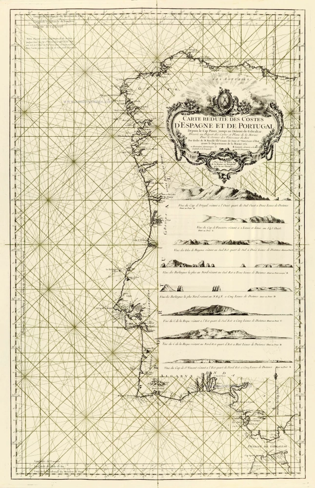
Carte Réduite des Costes d'Espagne et de Portugal. 1756-1770
Spain - Portugal, by J.N. Bellin.
[Item number: 28124]

Very important map.
Hispaniae Descriptio. 1559
Iberian Peninsula (Spain & Portugal) by Vincenzo Luchini.
[Item number: 28151]

Nova Hispaniae Descriptio. 1632
Spain by Joannes Janssonius.
[Item number: 28205]

Nova et accurata Tabula Hispaniae Praecipuis Urbibus Vestitu Insignibus et Antiquitatibus exornata. c. 1640
Spain & Portugal (Iberian Peninsula) by Cornelis Danckerts.
[Item number: 28211]

Novissima et Accuratissima Regnorum Hispaniae et Portugalliae. c. 1715
Iberian Peninsula (Spain & Portugal) by Covens & Mortier.
[Item number: 28238]

Rare!
Nova Regni Hispaniae Descriptio, de novo multis in locis aucta et emendata. 1605
Spain by Willem Blaeu
[Item number: 28367]

Totius Regnorum Hispaniae et Portugalliae. 1680
Iberian Peninsula (Spain & Portugal) by Frederick de Wit.
[Item number: 28604]

Les Estats de la Couronne de Castille, dans les Parties plus Septentrionales de l'Espagne: 1652
Northern Spain by Nicolas Sanson.
[Item number: 29660]

Les estats de la Couronne de Castille, dans les Parties plus Meridionales de l'Espagne: 1652
Southern Spain by Nicolas Sanson.
[Item number: 29661]

Hispaniae Antiquae Tabulae. 1652
Spain by Nicolas Sanson.
[Item number: 29694]

*** Rare first state. ***
Antiquorum Hispaniae Episcopatuum Geographica Descriptio. 1640
Ancient Iberian Peninsula (Spain & Portugal) by Melchior Tavernier.
[Item number: 30043]

Galecia. 1618
Galicia by Petrus Bertius, published by Jodocus Hondius II.
[Item number: 31546]

Regnorum Hispaniae nova descriptio. 1643
Iberian Peninsula (Spain & Portugal) by Willem Blaeu.
[Item number: 32155]

Regnorum Hispaniae et Portugalliae Tabula Generalis. c. 1720
Iberian Peninsula (Spain & Portugal) by J.B. Homann.
[Item number: 32160]

Accuratissima Totius Regni Hispaniae Tabula. c. 1680
Iberian Peninsula (Spain & Portugal) by Justus Danckerts
[Item number: 32462]

From the first Dutch folio printed sea atlas
Pascaart Vande Custen Van Andaluzia, Portugal, Gallissien, Biscajen en een gedeelte van Vranckryck ... | Tabula Hydrographica de Oris Andalusiae, Portugalliae, Galliciae, Biscaje et Aliqua Galliae parte ... 1650
Spanish coast by J. Janssonius.
[Item number: 32626]

Hispaniae Nova Describtio, de integro multis inlocis, secundum hydrographicas, desc. emendata. 1613
Iberian Peninsula (Spain & Portugal), by J. Hondius.
[Item number: 32703]

La Spagna. 1677
Iberian Peninsula (Spain & Portugal), by Guillaume & Nicolas Sanson, published by Giovanni Giacomo de Rossi.
[Item number: 32908]