
Cadiz, by Georg Braun and Frans Hogenberg, 1617
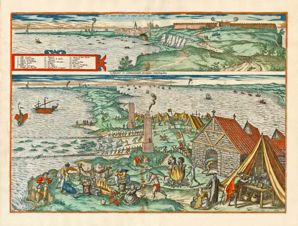
CAPTION TOP: The most noble and faithful city of Cadiz.
SIGNED CENTRE: drawn and provided by Georg Hoefnagel.
CAPTION BOTTOM: Almodrava de Cadiz, or tuna fishing near Cadiz.
COMMENTARY BY BRAUN (on verso): "This plate shows two tall watchtowers on the east side of the Island of Cadiz, which guard against enemy attack of the Berbers, Turks and Moors, who frequently seek to plunder this place from the sea, and which are therefore called the Torres de Guardia. At night, around the eleventh hour and later around the second hour, a group of citizens go out of the city of Cadiz and light burning torches of straw and hay and other materials on long pikes, so as to be able to give a warning signal."
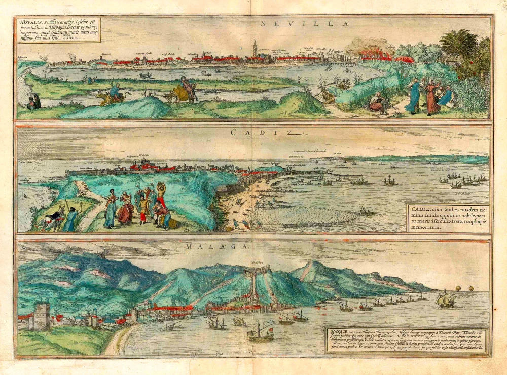
The sheet is divided horizontally into two unequal parts. In the upper picture, Cadiz is shown from the southeast, with the chapel of St Sebastian here on the far left and the city ramparts on the right. The lower view is presented from the same angle but from a greater distance, so that the entire Bay of Cadiz is visible. The city itself forms merely the backdrop to the illustrations of Cadiz's tuna-fishing industry. The artist records in detail how the fish are caught, cooked and packed and how the waste is incinerated. The watchtowers were primarily designed to protect the city from pirates (Cadiz was pillaged by pirates several times in the 16th century), but were also useful for observing the schools of fish. (Taschen)
Braun G. & Hogenberg F. and the Civitates Orbis Terrarum.
The Civitates Orbis Terrarum, also known as the 'Braun & Hogenberg', is a six-volume town atlas and the most excellent book of town views and plans ever published: 363 engravings, sometimes beautifully coloured. It was one of the best-selling works in the last quarter of the 16th century. Georg Braun, a skilled writer, wrote the text accompanying the plans and views on the verso. Many plates were engraved after the original drawings of a professional artist, Joris Hoefnagel (1542-1600). The first volume was published in Latin in 1572 and the sixth in 1617. Frans Hogenberg, a talented engraver, created the tables for volumes I through IV, and Simon van den Neuwel made those for volumes V and VI. Other contributors were cartographers Daniel Freese and Heinrich Rantzau, who provided valuable geographical information. Works by Jacob van Deventer, Sebastian Münster, and Johannes Stumpf were also used as references. Translations appeared in German and French, making the atlas accessible to a wider audience.
Since its original publication of volume 1 in 1572, the Civitates Orbis Terrarum has left an indelible mark on the history of cartography. The first volume was followed by seven more editions in 1575, 1577, 1582, 1588, 1593, 1599, and 1612. Vol.2, initially released in 1575, saw subsequent editions in 1597 and 1612. The subsequent volumes, each a treasure trove of historical insights, graced the world in 1581, 1588, 1593, 1599, and 1606. The German translation of the first volume, a testament to its widespread appeal, debuted in 1574, followed by the French edition in 1575.
Several printers were involved: Theodor Graminaeus, Heinrich von Aich, Gottfried von Kempen, Johannis Sinniger, Bertram Buchholtz, and Peter von Brachel, all of whom worked in Cologne.
Georg Braun (1541-1622)
Georg Braun, the author of the text accompanying the plans and views in the Civitates Orbis Terrarum, was born in Cologne in 1541. After his studies in Cologne, he entered the Jesuit Order as a novice, indicating his commitment to learning and intellectual pursuits. In 1561, he obtained his bachelor's degree; in 1562, he received his Magister Artium, further demonstrating his academic achievements. Although he left the Jesuit Order, he continued his studies in theology, gaining a licentiate in theology. His theological background likely influenced the content and tone of the text in the Civitates Orbis Terrarum, adding a unique perspective to the work.
Frans Hogenberg (1535-1590)
Frans Hogenberg was a Flemish and German painter, engraver, and mapmaker. He was born in Mechelen as the son of Nicolaas Hogenberg.
By the end of the 1560s, Frans Hogenberg was employed upon Abraham Ortelius's Theatrum Orbis Terrarum, published in 1570; he is named an engraver of numerous maps. In 1568, he was banned from Antwerp by the Duke of Alva and travelled to London, where he stayed a few years before emigrating to Cologne. He immediately embarked on his two most important works, the Civitates, published in 1572 and the Geschichtsblätter, which appeared in several series from 1569 until about 1587.
Thanks to large-scale projects like the Geschichtsblätter and the Civitates, Hogenberg's social circumstances improved with each passing year. He died as a wealthy man in Cologne in 1590.
La muy noble y muy leal cividas de Cadiz / Almodrava de Caditz sive Thynnorum piscatio apud Gades.
Item Number: 27637 Authenticity Guarantee
Category: Antique maps > Europe > Spain and Portugal
Antique map with two views of Cadiz, by Georg Braun and Frans Hogenberg, after Georg Hoefnagel.
Date of the first edition: 1596
Date of this map: 1617
Copper engraving, printed on paper.
Size (not including margins): 35.5 x 48.5cm (13.8 x 18.9 inches)
Verso text: Latin
Condition: Original coloured, a few small brown stains in centre.
Condition Rating: A
References: Van der Krogt 4, #712, State 1; Taschen, Br. Hog. p.354-356; Fauser, #2184.
CAPTION TOP: The most noble and faithful city of Cadiz.
SIGNED CENTRE: drawn and provided by Georg Hoefnagel.
CAPTION BOTTOM: Almodrava de Cadiz, or tuna fishing near Cadiz.
COMMENTARY BY BRAUN (on verso): "This plate shows two tall watchtowers on the east side of the Island of Cadiz, which guard against enemy attack of the Berbers, Turks and Moors, who frequently seek to plunder this place from the sea, and which are therefore called the Torres de Guardia. At night, around the eleventh hour and later around the second hour, a group of citizens go out of the city of Cadiz and light burning torches of straw and hay and other materials on long pikes, so as to be able to give a warning signal."
The sheet is divided horizontally into two unequal parts. In the upper picture, Cadiz is shown from the southeast, with the chapel of St Sebastian here on the far left and the city ramparts on the right. The lower view is presented from the same angle but from a greater distance, so that the entire Bay of Cadiz is visible. The city itself forms merely the backdrop to the illustrations of Cadiz's tuna-fishing industry. The artist records in detail how the fish are caught, cooked and packed and how the waste is incinerated. The watchtowers were primarily designed to protect the city from pirates (Cadiz was pillaged by pirates several times in the 16th century), but were also useful for observing the schools of fish. (Taschen)
Braun G. & Hogenberg F. and the Civitates Orbis Terrarum.
The Civitates Orbis Terrarum, also known as the 'Braun & Hogenberg', is a six-volume town atlas and the most excellent book of town views and plans ever published: 363 engravings, sometimes beautifully coloured. It was one of the best-selling works in the last quarter of the 16th century. Georg Braun, a skilled writer, wrote the text accompanying the plans and views on the verso. Many plates were engraved after the original drawings of a professional artist, Joris Hoefnagel (1542-1600). The first volume was published in Latin in 1572 and the sixth in 1617. Frans Hogenberg, a talented engraver, created the tables for volumes I through IV, and Simon van den Neuwel made those for volumes V and VI. Other contributors were cartographers Daniel Freese and Heinrich Rantzau, who provided valuable geographical information. Works by Jacob van Deventer, Sebastian Münster, and Johannes Stumpf were also used as references. Translations appeared in German and French, making the atlas accessible to a wider audience.
Since its original publication of volume 1 in 1572, the Civitates Orbis Terrarum has left an indelible mark on the history of cartography. The first volume was followed by seven more editions in 1575, 1577, 1582, 1588, 1593, 1599, and 1612. Vol.2, initially released in 1575, saw subsequent editions in 1597 and 1612. The subsequent volumes, each a treasure trove of historical insights, graced the world in 1581, 1588, 1593, 1599, and 1606. The German translation of the first volume, a testament to its widespread appeal, debuted in 1574, followed by the French edition in 1575.
Several printers were involved: Theodor Graminaeus, Heinrich von Aich, Gottfried von Kempen, Johannis Sinniger, Bertram Buchholtz, and Peter von Brachel, all of whom worked in Cologne.
Georg Braun (1541-1622)
Georg Braun, the author of the text accompanying the plans and views in the Civitates Orbis Terrarum, was born in Cologne in 1541. After his studies in Cologne, he entered the Jesuit Order as a novice, indicating his commitment to learning and intellectual pursuits. In 1561, he obtained his bachelor's degree; in 1562, he received his Magister Artium, further demonstrating his academic achievements. Although he left the Jesuit Order, he continued his studies in theology, gaining a licentiate in theology. His theological background likely influenced the content and tone of the text in the Civitates Orbis Terrarum, adding a unique perspective to the work.
Frans Hogenberg (1535-1590)
Frans Hogenberg was a Flemish and German painter, engraver, and mapmaker. He was born in Mechelen as the son of Nicolaas Hogenberg.
By the end of the 1560s, Frans Hogenberg was employed upon Abraham Ortelius's Theatrum Orbis Terrarum, published in 1570; he is named an engraver of numerous maps. In 1568, he was banned from Antwerp by the Duke of Alva and travelled to London, where he stayed a few years before emigrating to Cologne. He immediately embarked on his two most important works, the Civitates, published in 1572 and the Geschichtsblätter, which appeared in several series from 1569 until about 1587.
Thanks to large-scale projects like the Geschichtsblätter and the Civitates, Hogenberg's social circumstances improved with each passing year. He died as a wealthy man in Cologne in 1590.
Related items
Carpetaniae Partis - Vadulorum sive Guispucoae Regionis Typus - Cadiz Urbs hanc Insulam Perlustrabat ... 1609
Carpetania - Guipuzcoa - Cadiz, by Ortelius A.
[Item number: 1667]
Carpetaniae Partis - Vadulorum sive Guispucoae Regionis Typus - Cadiz Urbs hanc Insulam Perlustrabat ... 1601
Carpetania - Guipuzcoa - Cadiz, by A. Ortelius.
[Item number: 5749]
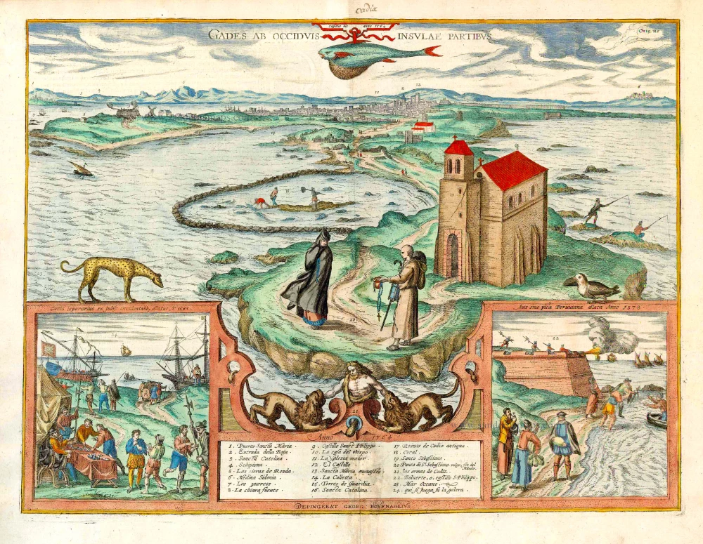
Gades ab Occiduis Insulae Partibus. 1623
Cadiz, by Braun Georg & Hogenberg Frans.
[Item number: 22059]
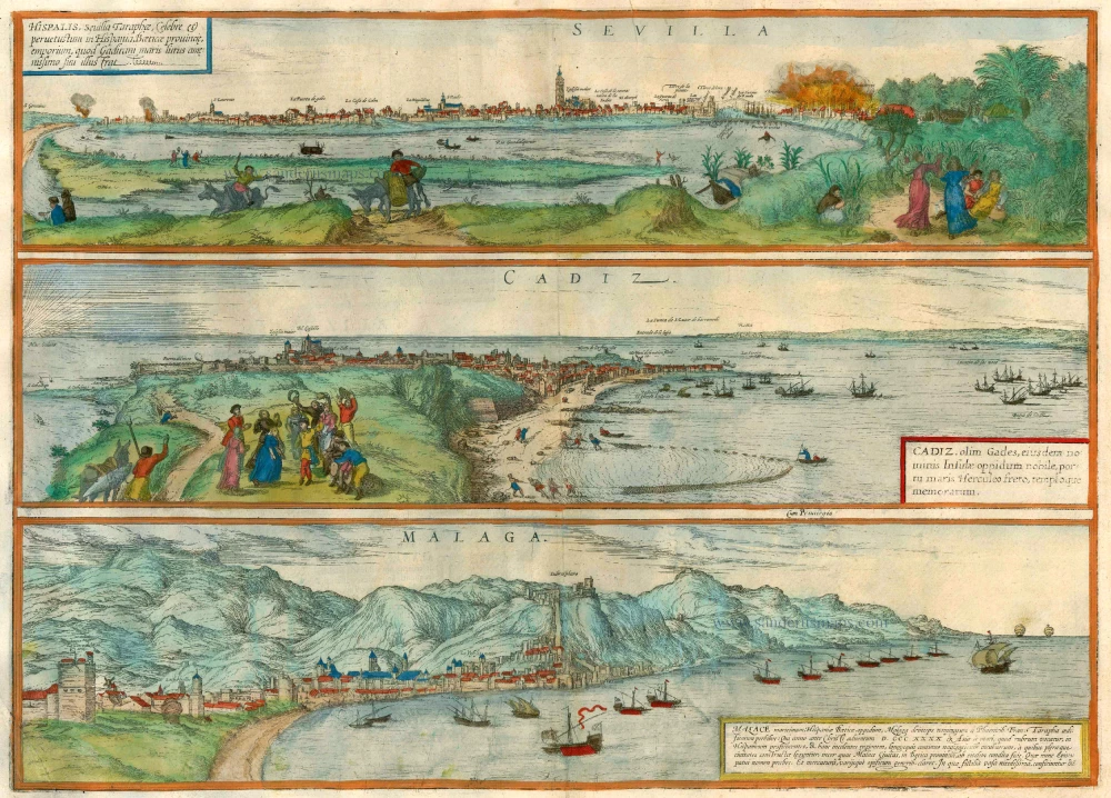
Sevilla, Hispalis ... [on sheet with] Cadiz [and] Malaga. 1572-1624
Antique map of Seville (Sevilla) - Cadiz - Malaga by Braun & Hogenberg
[Item number: 22685]
Carpetaniae Partis - Vadulorum sive Guispucoae Regionis Typus - Cadiz Urbs hanc Insulam Perlustrabat ... 1598
Carpetania - Guipuzcoa - Cadiz, by A. Ortelius.
[Item number: 22866]
Sevilla, Hispalis ... [on sheet with] Cadiz [and] Malaga. 1582
Seville (Sevilla) - Cadiz - Malaga, by Braun & Hogenberg.
[Item number: 25496]