
Montenegro, Northern Albania, Kosovo and the Dalmatian Coast. by Coronelli V.M. (1650-1718 1691
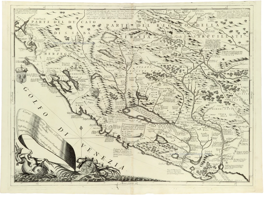
A magnificent and exceptionally detailed map of the western Balkans by the celebrated Venetian cosmographer Vincenzo Maria Coronelli, depicting the course of the Drin and Bojana (Buna) rivers, Lake Scutari (Lake Skadar), and the mountainous hinterland of the southeastern Adriatic coast.
The map covers a substantial part of the former Yugoslavia and present-day northern Albania, including Montenegro, parts of Bosnia and Herzegovina, southern Serbia, and Kosovo. It extends from the Adriatic coast and the Bay of Kotor in the west to the interior regions of Serbia in the east, encompassing the territories historically associated with Dalmatia, Albania, Herzegovina, and the Ottoman Empire.
Particularly noteworthy is the detailed representation of the Bay of Kotor (Bocche di Cattaro), with its numerous inlets, coastal settlements, and Venetian possessions. The towns of Kotor (Cattaro), Budva (Budua), Bar (Antivari), Ulcinj (Dulcigno), and Shkodër (Scutari) are identified, together with numerous smaller settlements, fortifications, and geographical features.
Lake Scutari occupies a prominent position in the lower central part of the map, while the courses of the Drin and Bojana rivers are carefully delineated. The surrounding mountainous landscape is depicted with elaborate pictorial relief, and extensive forests, rivers, lakes, and settlements are represented throughout the interior.
The map is especially interesting for its portrayal of the complex political geography of the region at the end of the seventeenth century, when the Republic of Venice and the Ottoman Empire competed for control of the eastern Adriatic and its hinterland. Numerous territorial inscriptions identify local districts, tribal regions, and administrative divisions, providing valuable evidence of contemporary geographical and political knowledge.
The engraving features a spectacular maritime cartouche in the lower left corner, with a large fish, a ribbon bearing the title and dedication, and an elaborate composition of maritime motifs. A compass rose and radiating rhumb lines decorate the Adriatic Sea, while several coats of arms and explanatory inscriptions enrich the geographical content.
Coronelli's map is a remarkable example of late seventeenth-century Venetian cartography, combining detailed geographical information with the decorative elegance characteristic of his monumental atlas productions. It is particularly valuable for the historical topography of Montenegro, northern Albania, and the adjoining Balkan territories during a period of intense Venetian-Ottoman rivalry.
Vincenzo Coronelli (1650-1718)
Vincenzo Coronelli was born in Venice on 16 August 1650 and primarily brought up in Ravenna. He returned to Venice in 1665 and joined the convent of the Minor Conventuals. Five years later, he was sent to Rome to study, and by 1673, he was already a doctor of theology.
Having achieved fame by constructing two globes for the Duke of Parma, he was invited to Paris for three years in 1681 and made two enormous examples for Louis XIV. On his return to Venice, he assiduously collected cartographic material and founded the Academy of the Argonauts. In 1685, he was appointed Cosmographer to the Republic of Venice and authorised to publish a large atlas. He became a geography lecturer at the University of Venice and brought out an Atlante Veneto the following year.
In 1696, he visited Germany, Holland and southern England. During intervals in compiling his vast encyclopaedia, he continued with cartographic projects up to 1709. He died in his native Venice on 9 December 1718.
Coronelli became famous for his globes. In addition, he was a renowned encyclopaedist, mapmaker and geographer. Most of his maps and other material are gathered in his Atlante Veneto (13 vols, 1690-1705). The first volume, subtitled Descrizione generale istorica geografica, was his masterpiece, planned as an extension of Blaeu’s atlas.
Other volumes of the atlas which contain maps are Isolario, two parts (1696-8), with detailed maps and plans, mostly of islands; Corso geografico, two parts based on the edition 1694-7; Libro de’ globi (1697); and Lo Specchio del Mare, a reprint of Levanto's Lo Specchio del Mare Mediterraneo of 1664.
The other vital aspects of his mapping are those arising from the Venetian conquest and his travels. His most extensive military compilation was the Teatro della Guerra, in more than 30 volumes.
Corso delli Fiumi Drino, e Boiana nella Dalmatia Descrito
Item Number: 33348 new Authenticity Guarantee
Category: Antique maps > Mediterranean Sea
The River Drin and Lake Scutari, with the Dalmatian Coast, by Vincenzo Maria Coronelli (1650–1718).
Title: Corso delli Fiumi Drino, e Boiana nella Dalmatia Descrito
Date: 1691.
Copper engraving, printed on paper.
Image size: 440 x 610mm (17¼ x 24 inches).
Sheet size: 475 x 650mm (18¾ x 25½ inches).
Verso: Blank.
Condition: Excellent.
Condition Rating: A+.
From: Atlante Veneto, nel quale si contiene la descrittione... degl' Imperii, Regni, Provincie, e Stati dell' Universo. Venice: Girolamo Albrizzi, 1691. Shirley (Brit.Lib.), T.CORO-7a
A magnificent and exceptionally detailed map of the western Balkans by the celebrated Venetian cosmographer Vincenzo Maria Coronelli, depicting the course of the Drin and Bojana (Buna) rivers, Lake Scutari (Lake Skadar), and the mountainous hinterland of the southeastern Adriatic coast.
The map covers a substantial part of the former Yugoslavia and present-day northern Albania, including Montenegro, parts of Bosnia and Herzegovina, southern Serbia, and Kosovo. It extends from the Adriatic coast and the Bay of Kotor in the west to the interior regions of Serbia in the east, encompassing the territories historically associated with Dalmatia, Albania, Herzegovina, and the Ottoman Empire.
Particularly noteworthy is the detailed representation of the Bay of Kotor (Bocche di Cattaro), with its numerous inlets, coastal settlements, and Venetian possessions. The towns of Kotor (Cattaro), Budva (Budua), Bar (Antivari), Ulcinj (Dulcigno), and Shkodër (Scutari) are identified, together with numerous smaller settlements, fortifications, and geographical features.
Lake Scutari occupies a prominent position in the lower central part of the map, while the courses of the Drin and Bojana rivers are carefully delineated. The surrounding mountainous landscape is depicted with elaborate pictorial relief, and extensive forests, rivers, lakes, and settlements are represented throughout the interior.
The map is especially interesting for its portrayal of the complex political geography of the region at the end of the seventeenth century, when the Republic of Venice and the Ottoman Empire competed for control of the eastern Adriatic and its hinterland. Numerous territorial inscriptions identify local districts, tribal regions, and administrative divisions, providing valuable evidence of contemporary geographical and political knowledge.
The engraving features a spectacular maritime cartouche in the lower left corner, with a large fish, a ribbon bearing the title and dedication, and an elaborate composition of maritime motifs. A compass rose and radiating rhumb lines decorate the Adriatic Sea, while several coats of arms and explanatory inscriptions enrich the geographical content.
Coronelli's map is a remarkable example of late seventeenth-century Venetian cartography, combining detailed geographical information with the decorative elegance characteristic of his monumental atlas productions. It is particularly valuable for the historical topography of Montenegro, northern Albania, and the adjoining Balkan territories during a period of intense Venetian-Ottoman rivalry.
Vincenzo Coronelli (1650-1718)
Vincenzo Coronelli was born in Venice on 16 August 1650 and primarily brought up in Ravenna. He returned to Venice in 1665 and joined the convent of the Minor Conventuals. Five years later, he was sent to Rome to study, and by 1673, he was already a doctor of theology.
Having achieved fame by constructing two globes for the Duke of Parma, he was invited to Paris for three years in 1681 and made two enormous examples for Louis XIV. On his return to Venice, he assiduously collected cartographic material and founded the Academy of the Argonauts. In 1685, he was appointed Cosmographer to the Republic of Venice and authorised to publish a large atlas. He became a geography lecturer at the University of Venice and brought out an Atlante Veneto the following year.
In 1696, he visited Germany, Holland and southern England. During intervals in compiling his vast encyclopaedia, he continued with cartographic projects up to 1709. He died in his native Venice on 9 December 1718.
Coronelli became famous for his globes. In addition, he was a renowned encyclopaedist, mapmaker and geographer. Most of his maps and other material are gathered in his Atlante Veneto (13 vols, 1690-1705). The first volume, subtitled Descrizione generale istorica geografica, was his masterpiece, planned as an extension of Blaeu’s atlas.
Other volumes of the atlas which contain maps are Isolario, two parts (1696-8), with detailed maps and plans, mostly of islands; Corso geografico, two parts based on the edition 1694-7; Libro de’ globi (1697); and Lo Specchio del Mare, a reprint of Levanto's Lo Specchio del Mare Mediterraneo of 1664.
The other vital aspects of his mapping are those arising from the Venetian conquest and his travels. His most extensive military compilation was the Teatro della Guerra, in more than 30 volumes.
Related items

Sclavonia, Croatia, Bosnia cum Dalmatiae Parte. 1635
Western Balkans by Willem Blaeu.
[Item number: 6491]

Schlavoniae, Croatiae, Carniae, Istriae, Bosniae, finitimarumque Regionum Nova Descriptio, ... 1601
The Western Balkans by Abraham Ortelius.
[Item number: 8080]

Sclavonia, Croatia, Bosnia cum Dalmatiae Parte 1619
Balkans (West) by Mercator-Hondius
[Item number: 12223]

Sclavonia, Croatia, Bosnia cum Dalmatiae Parte 1613-16
Western Balkans by G. Mercator
[Item number: 13749]

Schlavoniae, Croatiae, Carniae, Istriae, Bosniae, finitimarumque Regionum Nova Descriptio, ... 1598
Western Balkans, by A. Ortelius.
[Item number: 22920]

Schlavoniae, Croatiae, Carniae, Istriae, Bosniae, finitimarumque Regionum Nova Descriptio, ... 1579
Western Balkans, by A. Ortelius.
[Item number: 23650]
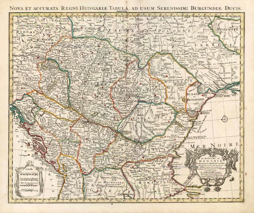
Le Royaume de Hongrie et des Pays qui en dependoient autrefois. 1730
Balkans by Guillaume Delisle - Covens & Mortier
[Item number: 25910]

Sclavonia, Croatia, Bosnia cum Dalmatiae Parte. 1641
The western Balkans, by Henricus Hondius.
[Item number: 27085]

[No title] - [On verso:] Tabula .V. Europae. 1525
Balkans - Dalmatia, by Lorenz Fries.
[Item number: 27959]

Walachia, Servia, Bulgaria, Romania. 1644-45
Eastern Balkan, by Willem Blaeu.
[Item number: 28594]

Rare first state
Totius Regni Hungariae, Maximaeque Partis Danubii Fluminis, una cum adjacentibus et finitimis Regionibus. c. 1665
Hungary & Balkans by Nicolaes Visscher I.
[Item number: 28595]

Sclavonia, Croatia, Bosnia cum Dalmatiae Parte c. 1610-1650
Western Balkans by G. Mercator.
[Item number: 31207]

Le Royaume de Hongrie et les Estats qui en ont este Sujets et qui font presentement la partie septentrionale de la Turquie en Europe. 1692
Hungary and Balkans by N. Sanson, so-called published by Hubert Jaillot. (Pirated edition by Pierre Mortier).
[Item number: 31267]

Illyricum. 1618
Balkan (West) by Petrus Bertius, published by Jodocus Hondius II.
[Item number: 31646]

Il Regno d'Ungaria Transilvania, Schivonia, Bosnia, Croatia, Dalmatia; 1687
Western Balkans and Central Europe, by Guillaume Sanson, published by Giovanni de Rossi.
[Item number: 32954]