
Western Balkans and Central Europe, by Guillaume Sanson, published by Giovanni de Rossi. 1687

de Rossi Family
Seventeenth-century Rome was home to the famous publishing house of de Rossi. Two branches of the family used the addresses in Piazza Navona and Piazza della Pace; the latter was the more important house. Giuseppe de Rossi founded the house in 1613 and continued until he died in 1639. Giovanni Giacomo de Rossi flourished from 1649 to 1691. In 1677, he published a folio atlas titled Mercurio Geografico. It was drawn almost entirely from the cartography of the Sanson family in Paris. Whether it was with their permission or simple plagiarism is unknown, but they are credited. (Burden)
Giuseppe Rossi (flourished 1613-1639), Publisher at 'Piazza della Pace'.
Giovanni Giacomo de Rossi (1627-1691), Printer and publisher at 'Alla Pace all'insegna di Parigi', Rome.
Domenico de Rossi (flourished c. 1691-c. 1720), Successor to Giovanni Giacomo Rossi.
Lorenzo Filippo Rossi (flourished c. 1720-1738). Successor to Domenico.
In 1738, the Rossi plates were sold to the government of the Papal States.
SANSON FAMILY
Nicolas Sanson (1600-1667) - Guillaume Sanson (1633-1703) - Pierre Moullart-Sanson (? -1730)
Originally from Abbeville, Nicolas I Sanson showed a keen interest in historical geography. He was still very young; he published a map of ancient Gaul and two treatises, Britannia and Portus Itius on Abbeville and Boulogne's origins. His meeting with Melchior Tavernier was decisive: it prompted him to give up his duties as a military engineer in Picardy and devote himself to engraved cartography.
At the same time, Sanson had drawn up the outline of modern France. He got the help of Tavernier, who encouraged him to compete with the Dutch map publishers. Tavernier contacted other French cartographers whose works he published.
From 1643, N. Sanson obtained a privilege to publish a work personally, the Princes souverains de l'Italie. Then, in 1644 and 1645, he had his famous geographical tables printed, which significantly contributed to his fame. He also published a series of atlases in quarto of the four continents.
In 1648, N. Sanson associated himself with Mariette to publish atlases. From then on, specific maps bore his name and others Mariette's. N. Sanson and Mariette worked together for more than 20 years. After the death of N. Sanson, Mariette acquired the entire fund. Since Mariette only wanted to publish complete atlases, individual maps were no longer sold, and some army generals complained to the king.
The disagreement between the Sanson family and Pierre II Mariette culminated in 1671 when Guillaume Sanson took the case to court. There was no longer any question of collaboration: Guillaume Sanson started working for another publisher, Alexis-Hubert Jaillot.
The Sanson family faced financial difficulties, and in 1692, their cousin, Pierre Moullart-Sanson, bought the entire geographic fund from his uncles and aunt. Pierre Moullart-Sanson was the son of Françoise Sanson (third child of Nicolas) and Pierre Moullart. He restarted the publishing of Sanson's world atlas, and in 1704 he acquired a privilege for publishing all the works of Nicolas and Guillaume Sanson, which continued to be published until 1730.
Il Regno d'Ungaria Transilvania, Schivonia, Bosnia, Croatia, Dalmatia;
Item Number: 32954 Authenticity Guarantee
Category: Antique maps > Europe > Southeastern Europe
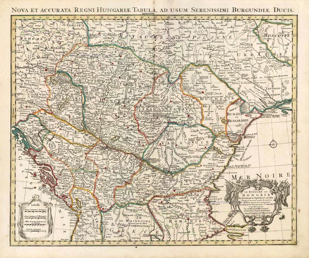
Western Balkans and Central Europe, by Guillaume Sanson, published by Giovanni de Rossi.
Title: Il Regno d'Ungaria Transilvania, Schivonia, Bosnia, Croatia, Dalmatia;
divisi da Guglielmo Sansone, come al presente si trovano trà La Casa d'Austria, La Rep[publi]ca di Venetia et il Turco.
al quale spettano li Beglierbati ò Governi di Buda, di Temisvar, e di Bosnia.
di nuovo data in luce da Gio. Giac.o Roßi in Roma, alla Pace l'An° 1683.
Date of the first edition: 1683.
Date of this map: 1687.
Date on map: 1683.
Copper engraving, printed on paper.
Image size: 425 x 545mm (16¾ x 21½ inches).
Sheet size: 475 x 620mm (18¾ x 24½ inches).
Verso: Blank.
Condition: Original coloured in outline, excellent.
Condition Rating: A+.
From: Mercurio Geografico overo Guida Geografica in Tutte le Parti di Mondo Conforme le Tavole Geografiche del Sansone Baudrand e Cantelli. Rome, [1687]. (Shirley (Brit. Lib.), T.ROSS-1b)
de Rossi Family
Seventeenth-century Rome was home to the famous publishing house of de Rossi. Two branches of the family used the addresses in Piazza Navona and Piazza della Pace; the latter was the more important house. Giuseppe de Rossi founded the house in 1613 and continued until he died in 1639. Giovanni Giacomo de Rossi flourished from 1649 to 1691. In 1677, he published a folio atlas titled Mercurio Geografico. It was drawn almost entirely from the cartography of the Sanson family in Paris. Whether it was with their permission or simple plagiarism is unknown, but they are credited. (Burden)
Giuseppe Rossi (flourished 1613-1639), Publisher at 'Piazza della Pace'.
Giovanni Giacomo de Rossi (1627-1691), Printer and publisher at 'Alla Pace all'insegna di Parigi', Rome.
Domenico de Rossi (flourished c. 1691-c. 1720), Successor to Giovanni Giacomo Rossi.
Lorenzo Filippo Rossi (flourished c. 1720-1738). Successor to Domenico.
In 1738, the Rossi plates were sold to the government of the Papal States.
SANSON FAMILY
Nicolas Sanson (1600-1667) - Guillaume Sanson (1633-1703) - Pierre Moullart-Sanson (? -1730)
Originally from Abbeville, Nicolas I Sanson showed a keen interest in historical geography. He was still very young; he published a map of ancient Gaul and two treatises, Britannia and Portus Itius on Abbeville and Boulogne's origins. His meeting with Melchior Tavernier was decisive: it prompted him to give up his duties as a military engineer in Picardy and devote himself to engraved cartography.
At the same time, Sanson had drawn up the outline of modern France. He got the help of Tavernier, who encouraged him to compete with the Dutch map publishers. Tavernier contacted other French cartographers whose works he published.
From 1643, N. Sanson obtained a privilege to publish a work personally, the Princes souverains de l'Italie. Then, in 1644 and 1645, he had his famous geographical tables printed, which significantly contributed to his fame. He also published a series of atlases in quarto of the four continents.
In 1648, N. Sanson associated himself with Mariette to publish atlases. From then on, specific maps bore his name and others Mariette's. N. Sanson and Mariette worked together for more than 20 years. After the death of N. Sanson, Mariette acquired the entire fund. Since Mariette only wanted to publish complete atlases, individual maps were no longer sold, and some army generals complained to the king.
The disagreement between the Sanson family and Pierre II Mariette culminated in 1671 when Guillaume Sanson took the case to court. There was no longer any question of collaboration: Guillaume Sanson started working for another publisher, Alexis-Hubert Jaillot.
The Sanson family faced financial difficulties, and in 1692, their cousin, Pierre Moullart-Sanson, bought the entire geographic fund from his uncles and aunt. Pierre Moullart-Sanson was the son of Françoise Sanson (third child of Nicolas) and Pierre Moullart. He restarted the publishing of Sanson's world atlas, and in 1704 he acquired a privilege for publishing all the works of Nicolas and Guillaume Sanson, which continued to be published until 1730.
Related items

Hungariae Descriptio, Wolfgango Lazio Auct. 1612
Hungary by Abraham Ortelius.
[Item number: 23084]

Hungaria 1623
Hungary, by Gerard Mercator.
[Item number: 24948]
Le Royaume de Hongrie et des Pays qui en dependoient autrefois. 1730
Balkans by Guillaume Delisle - Covens & Mortier
[Item number: 25910]
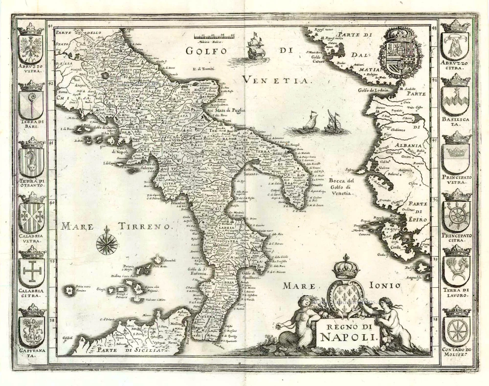
Regno di Napoli. 1638
Southern Italy, by M. Merian.
[Item number: 25925]

La Hongrie, Suivant les Nouvelles Observations de Mess.rs de l'Academie Royale des Sciences, 1713
Hungary, by Pieter van der Aa.
[Item number: 26043]

La ville d'Eger, iadis subiette à l'empire romain et auiourd'huy au royaume de Bohem. 1575
Eger (Hungary), by François de Belleforest.
[Item number: 27372]

Totius Regni Hungariae, Maximaeque Partis Danubii Fluminis, una cum adjacentibus et finitimis Regionibus. 1656-80
Hungary & Balkans by Nicolaes Visscher I.
[Item number: 28595]
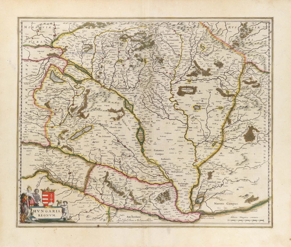
Hungaria Regnum. 1644-45
Hungary, by Willem & Joan Blaeu.
[Item number: 28654]
new

Hungariae Descriptio, Wolfgango Lazio Auct. 1584
Hungary by Abraham Ortelius.
[Item number: 30026]

Hungaria Regnum. 1653
Hungary by Johannes Janssonius.
[Item number: 30410]
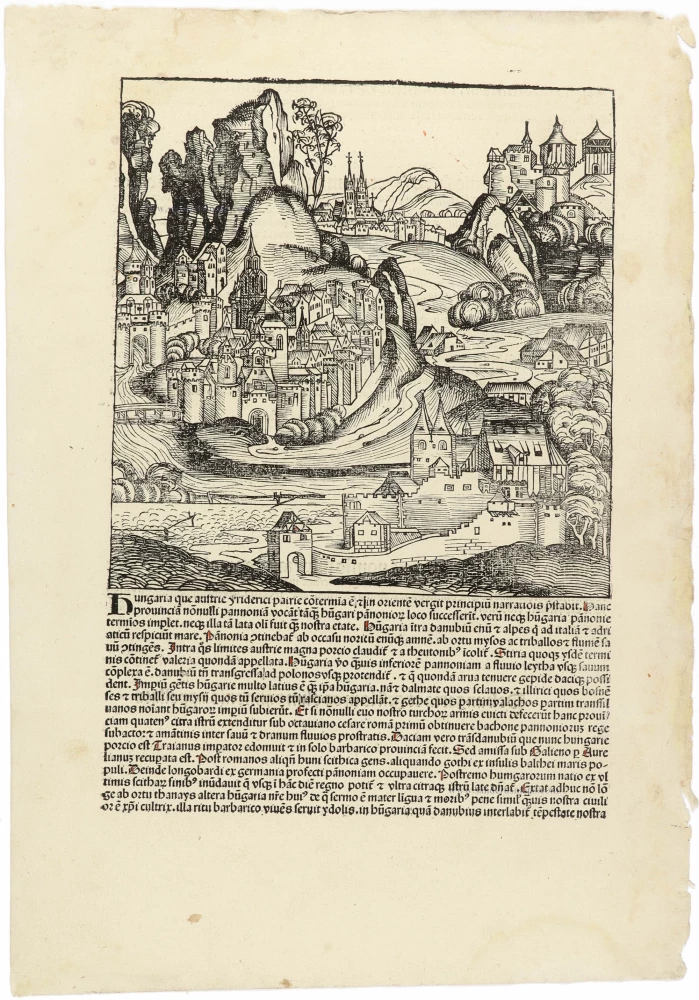
Hungaria CCLXVIII 1493
Fantasy view of Hungary, by Hartmann Schedel.
[Item number: 30954]

Das Königreich Ungarn nebst den angraentzenden Kaeyserlichen Laendern c. 1745.
Hungary by J.G. Schreiber.
[Item number: 31109]

Le Royaume de Hongrie et les Estats qui en ont este Sujets et qui font presentement la partie septentrionale de la Turquie en Europe. 1692
Hungary and Balkans by N. Sanson, so-called published by Hubert Jaillot. (Pirated edition by Pierre Mortier).
[Item number: 31267]

Hungaria 1618
Hungary by Petrus Bertius, published by Jodocus Hondius II.
[Item number: 31647]

Il Regno di Ungheria 1779-1785
Hungary, by Antonio Zatta.
[Item number: 32169]

Rare first state.
Regnorum Hungariae Dalmatiae, Croatiae, Sclavoniae, Bosniae, Serviae et Principatus Transylvaniae c. 1720
Hungary, by J.B. Homann.
[Item number: 32407]

Scarce
Novissima et Accuratissima Totius Hungariae Tabula. c. 1680
Hungary by Pierre Du Val, published by Justus Danckerts.
[Item number: 32510]
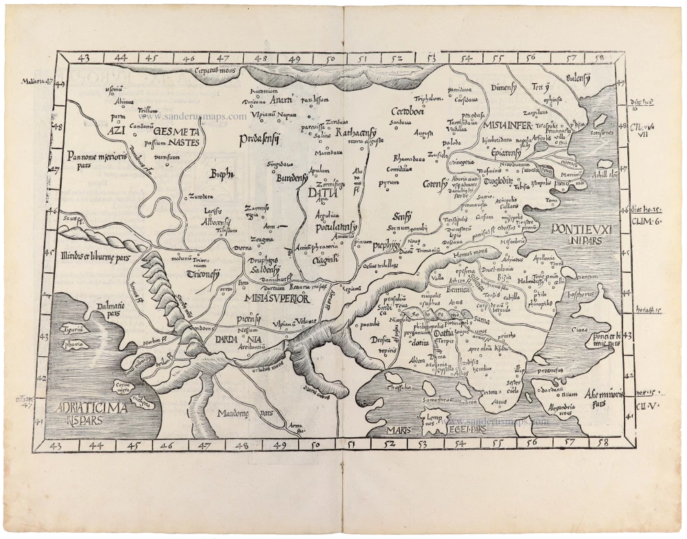
Tabula .IX. Europae. [Title on verso] 1525
Southeastern Europe (Hungary, Rumania, Bulgaria, Bosphorus), by Lorenz Fries.
[Item number: 32717]

With interesting text in the margins
Hungaria Regnum. c. 1610-1650
Hungary, by Willem & Joan Blaeu.
[Item number: 33031]