
With interesting text in the margins
Hungary, by Willem & Joan Blaeu. c. 1610-1650

The Blaeus: Willem Janszoon, Cornelis & Joan
Willem Jansz. Blaeu and his son Joan Blaeu are the seventeenth century's most widely known cartographic publishers.
Willem Jansz. (also written Guilielmus Janssonius) = Willem Janszoon Blaeu was born in Uitgeest (Netherlands), near Alkmaar, in 1571. He studied mathematics under Tycho Brahe and learned the theory and practice of astronomical observations and the art of instrument- and globe-making.
In 1596, he came to Amsterdam, where he settled down as a globe-, instrument- and mapmaker. He published his first cartographic work (a globe) in 1599 and probably published his first printed map (a map of the Netherlands) in 1604. He specialised in maritime cartography, published the first edition of the pilot guide Het Licht der Zeevaert in 1608, and was appointed Hydrographer of the V.O.C. (United East India Company) in 1633. After publishing books, wall maps, globes, charts and pilot guides for thirty years, he brought out his first atlas, Atlas Appendix (1630). This was the beginning of the great tradition of atlas-making by the Blaeus.
In 1618, another mapmaker, bookseller and publisher, Johannes Janssonius, established himself in Amsterdam next door to Blaeu's shop. No wonder these two neighbours began accusing each other of copying and stealing their information and became fierce competitors who did not have a good word to say about each other. In about 1621 Willem Jansz. decided to end the confusion between his name and his competitor's and assumed his grandfather's nickname, 'blauwe Willem' ('blue Willem'), as the family name; after that, he called himself Willem Jansz. Blaeu.
Willem Janszoon Blaeu died in 1638, leaving his prospering business to his sons, Cornelis and Joan. We only know that Cornelis's name occurs in the prefaces of books and atlases until c. 1645.
Joan Blaeu, born in Amsterdam in 1596, became a partner in his father's book trade and printing business. 1638, he was appointed his father's successor in the Hydrographic Office of the V.O.C. His efforts culminated in the magnificent Atlas Major and the town books of the Netherlands and Italy – works unsurpassed in history and modern times, giving eternal fame to the name of the Blaeu's.
A fire ruined the business on February 23, 1672, and one year later, Dr. Joan Blaeu died. The fire and the director's passing caused the complete sale of the Blaeu House's stock. Five public auctions dispersed the remaining books, atlases, copperplates, globes, etc., among many other map dealers and publishers in Amsterdam. The majority was acquired by several booksellers acting in partnership.
In the succeeding years, the remaining printing department remained in the hands of the Blaeu family until 1695, when the printing house's inventory was sold at a public auction. That meant the end of the Blaeu family as a printing house of world renown.
Hungaria Regnum.
Item Number: 33031 Authenticity Guarantee
Category: Antique maps > Europe > Central Europe
Hungary, by Willem & Joan Blaeu.
Title: Hungaria Regnum.
Amsterdami Apud Guiljelmum et Johannem Blaeu.
Date of the first edition: 1634.
Date of this map: 1644-45.
Copper engraving, printed on heavy paper.
Side margins extended, with an old handwritten French explanatory text.
Image size: 420 x 510mm (16½ x 20 inches).
Sheet size: 510 x 690mm (20 x 27¼ inches).
Verso: Blank
Condition: Original coloured in outline, some age-toning stains, worm trace in the bottom margin.
Condition Rating: B+.
Separate publication - from a French Composite Atlas, c. 1610-1650.
The Blaeus: Willem Janszoon, Cornelis & Joan
Willem Jansz. Blaeu and his son Joan Blaeu are the seventeenth century's most widely known cartographic publishers.
Willem Jansz. (also written Guilielmus Janssonius) = Willem Janszoon Blaeu was born in Uitgeest (Netherlands), near Alkmaar, in 1571. He studied mathematics under Tycho Brahe and learned the theory and practice of astronomical observations and the art of instrument- and globe-making.
In 1596, he came to Amsterdam, where he settled down as a globe-, instrument- and mapmaker. He published his first cartographic work (a globe) in 1599 and probably published his first printed map (a map of the Netherlands) in 1604. He specialised in maritime cartography, published the first edition of the pilot guide Het Licht der Zeevaert in 1608, and was appointed Hydrographer of the V.O.C. (United East India Company) in 1633. After publishing books, wall maps, globes, charts and pilot guides for thirty years, he brought out his first atlas, Atlas Appendix (1630). This was the beginning of the great tradition of atlas-making by the Blaeus.
In 1618, another mapmaker, bookseller and publisher, Johannes Janssonius, established himself in Amsterdam next door to Blaeu's shop. No wonder these two neighbours began accusing each other of copying and stealing their information and became fierce competitors who did not have a good word to say about each other. In about 1621 Willem Jansz. decided to end the confusion between his name and his competitor's and assumed his grandfather's nickname, 'blauwe Willem' ('blue Willem'), as the family name; after that, he called himself Willem Jansz. Blaeu.
Willem Janszoon Blaeu died in 1638, leaving his prospering business to his sons, Cornelis and Joan. We only know that Cornelis's name occurs in the prefaces of books and atlases until c. 1645.
Joan Blaeu, born in Amsterdam in 1596, became a partner in his father's book trade and printing business. 1638, he was appointed his father's successor in the Hydrographic Office of the V.O.C. His efforts culminated in the magnificent Atlas Major and the town books of the Netherlands and Italy – works unsurpassed in history and modern times, giving eternal fame to the name of the Blaeu's.
A fire ruined the business on February 23, 1672, and one year later, Dr. Joan Blaeu died. The fire and the director's passing caused the complete sale of the Blaeu House's stock. Five public auctions dispersed the remaining books, atlases, copperplates, globes, etc., among many other map dealers and publishers in Amsterdam. The majority was acquired by several booksellers acting in partnership.
In the succeeding years, the remaining printing department remained in the hands of the Blaeu family until 1695, when the printing house's inventory was sold at a public auction. That meant the end of the Blaeu family as a printing house of world renown.
Related items

Dotis Ungaris Thata c. 1625
Tata (Hungary) by Braun G. & Hogenberg F.
[Item number: 16381]

Palanka Superioris Hungariae civitas. c. 1625
Drégelypalank (Hungary), by Georg Braun and Frans Hogenberg.
[Item number: 16456]

Hungariae Descriptio, Wolfgango Lazio Auct. 1612
Hungary by Abraham Ortelius.
[Item number: 23084]

Hungaria 1623
Hungary, by Gerard Mercator.
[Item number: 24948]
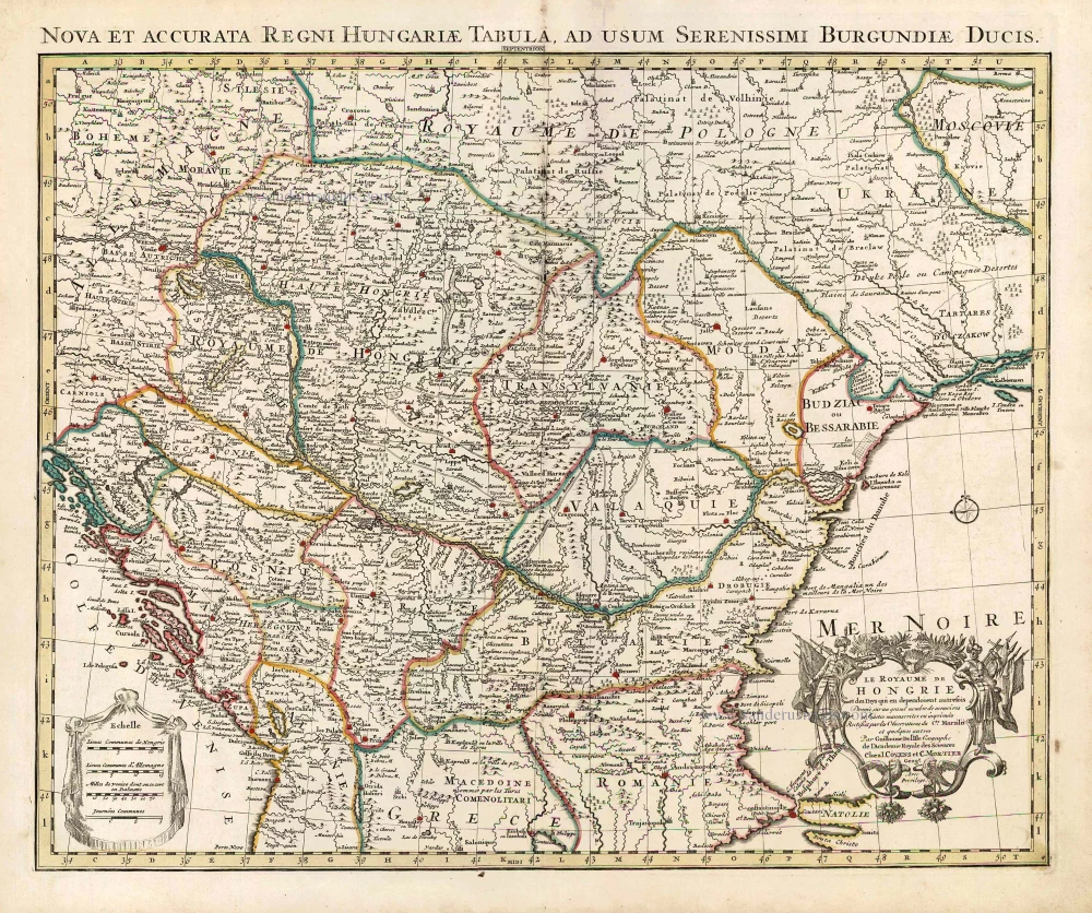
Le Royaume de Hongrie et des Pays qui en dependoient autrefois. 1730
Balkans by Guillaume Delisle - Covens & Mortier
[Item number: 25910]

La Hongrie, Suivant les Nouvelles Observations de Mess.rs de l'Academie Royale des Sciences, 1713
Hungary, by Pieter van der Aa.
[Item number: 26043]

La ville d'Eger, iadis subiette à l'empire romain et auiourd'huy au royaume de Bohem. 1575
Eger (Hungary), by François de Belleforest.
[Item number: 27372]

Totius Regni Hungariae, Maximaeque Partis Danubii Fluminis, una cum adjacentibus et finitimis Regionibus. 1656-80
Hungary & Balkans by Nicolaes Visscher I.
[Item number: 28595]
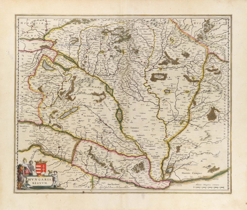
Hungaria Regnum. 1644-45
Hungary, by Willem & Joan Blaeu.
[Item number: 28654]
new

Hungariae Descriptio, Wolfgango Lazio Auct. 1584
Hungary by Abraham Ortelius.
[Item number: 30026]

Hungaria Regnum. 1653
Hungary by Johannes Janssonius.
[Item number: 30410]
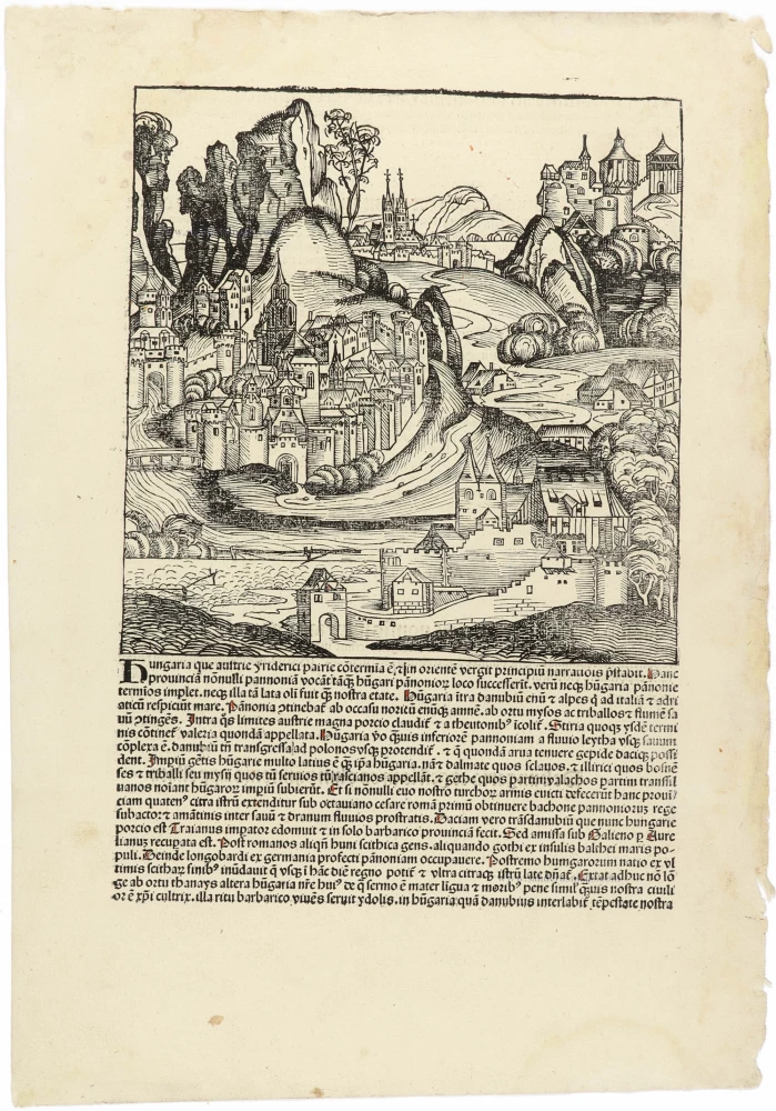
Hungaria CCLXVIII 1493
Fantasy view of Hungary, by Hartmann Schedel.
[Item number: 30954]

Das Königreich Ungarn nebst den angraentzenden Kaeyserlichen Laendern c. 1745.
Hungary by J.G. Schreiber.
[Item number: 31109]

Le Royaume de Hongrie et les Estats qui en ont este Sujets et qui font presentement la partie septentrionale de la Turquie en Europe. 1692
Hungary and Balkans by N. Sanson, so-called published by Hubert Jaillot. (Pirated edition by Pierre Mortier).
[Item number: 31267]

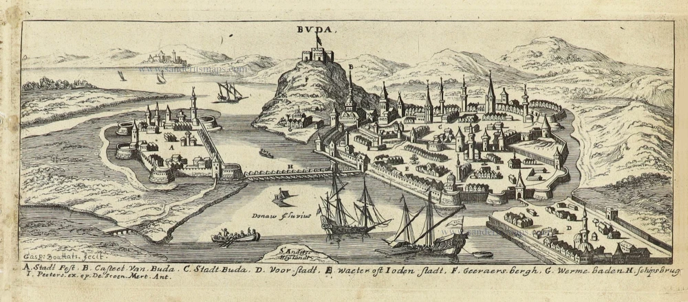
Buda vulgo Offen c. 1690
Budapest: Buda (Hungary) by J. Peeters.
[Item number: 31390]
Buda. c. 1690
Budapest: Buda (Hungary) by J. Peeters.
[Item number: 31397]

Hungaria 1618
Hungary by Petrus Bertius, published by Jodocus Hondius II.
[Item number: 31647]
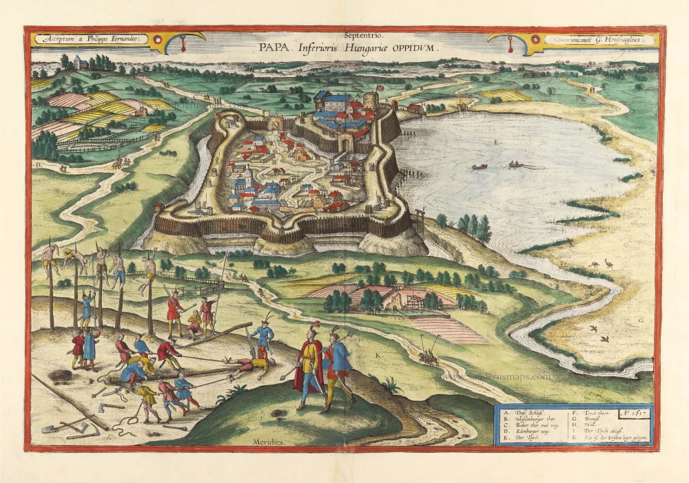
With torture scene. Scarce
Papa, Inferioris Hungariae Oppidum. 1618
Pápa in Hungary, by Georg Braun and Frans Hogenberg, after Georg Hoefnagel.
[Item number: 31782]

Il Regno di Ungheria 1779-1785
Hungary, by Antonio Zatta.
[Item number: 32169]

Rare first state.
Regnorum Hungariae Dalmatiae, Croatiae, Sclavoniae, Bosniae, Serviae et Principatus Transylvaniae c. 1720
Hungary, by J.B. Homann.
[Item number: 32407]

Scarce
Novissima et Accuratissima Totius Hungariae Tabula. c. 1680
Hungary by Pierre Du Val, published by Justus Danckerts.
[Item number: 32510]

Il Regno d'Ungaria Transilvania, Schivonia, Bosnia, Croatia, Dalmatia; 1687
Western Balkans and Central Europe, by Guillaume Sanson, published by Giovanni de Rossi.
[Item number: 32954]