
Scarce
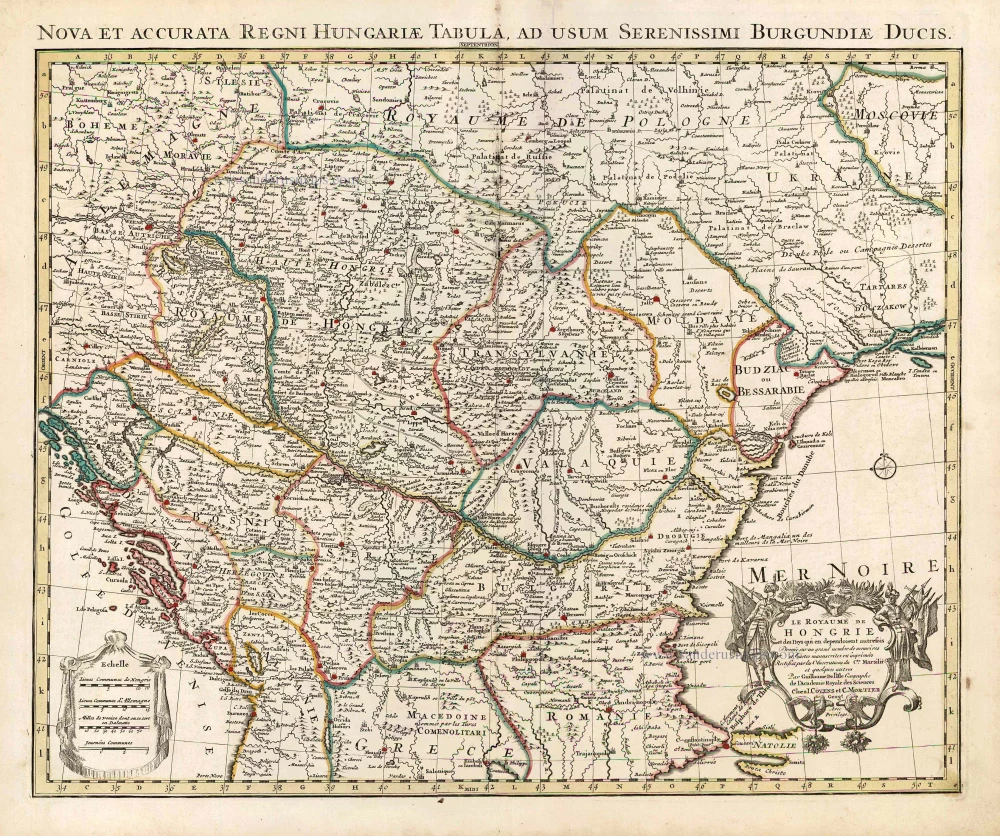
Hungary by Pierre Du Val, published by Justus Danckerts. c. 1680


The Danckerts Family.
The Danckerts family of Amsterdam was one of the best-known print and map sellers in 17th century Amsterdam. Their business activity covered a vast period, from ca. 1633. From 1669 until 1701, father Justus and his sons had their shop in the ‘Calverstraet in de Danckbaerheyt’.
Cornelis Danckerts (1561-1631) was a printseller born in Amsterdam and active in Antwerp.
Cornelis Danckerts, the elder (1603-1656) was an engraver and publisher in Amsterdam and Nieuwendijk. Son of Cornelis (above), whom he succeeded in 1631.
The house of Danckerts gained its greatest fame from Justus Danckerts (1635-1701 - son of Cornelis the elder) and his two sons, Theodorus and Cornelis. Dancker Danckerts (1634-1666), the elder brother of Justus, was known for his etchings of paintings, maps, and publications.
The grandfather, father, and sons were highly skilled and excellent artistic drafters and engravers. They are famous for the edition of their Atlas, which appeared from ca. 1686, and for several monumental and beautiful wall maps and views. However, compared with that published by the Blaeu's or Janssonius's, their cartographic work has attracted little attention and has never received proper recognition.
On 14 August 1684, Justus and his sons obtained the privilege from the States of Holland for their publications. In 1713, twelve years after Justus Danckerts, the heirs decided to sell part of the stock of maps and atlases and many copperplates. In 1727, after the death of the last surviving brother Theodorus, a final sale took place.
Pierre Duval (1618-1683)
Nephew and pupil of Nicolas Sanson. 'Géographe ordinaire du Roy'. He published a large number of maps.
Novissima et Accuratissima Totius Hungariae Tabula.
Item Number: 32510 Authenticity Guarantee
Category: Antique maps > Europe > Central Europe
Hungary by Pierre Du Val, published by Justus Danckerts.
Title: Novissima et Accuratissima Totius Hungariae Tabula.
Par P. Du Val Geographe du Roy
t' Amsterdam Gedruckt by Justus Danckers.
Cum Privilegio Ordinum Hollandiae et West-Frisiae.
Cartographer: P. Du Val.
Date of the first edition: c. 1680
Date of this map: c. 1680.
Copper engraving, printed on paper.
Image size: 395 x 475mm (15½ x 18¾ inches).
Sheet size: 530 x 620mm (20¾ x 24½ inches).
Verso: Blank.
Condition: Original coloured, excellent.
Condition Rating: A+.
From: Atlas. Amsterdam, c. 1680. (Koeman II, p. 91, Dan1)
The Danckerts Family.
The Danckerts family of Amsterdam was one of the best-known print and map sellers in 17th century Amsterdam. Their business activity covered a vast period, from ca. 1633. From 1669 until 1701, father Justus and his sons had their shop in the ‘Calverstraet in de Danckbaerheyt’.
Cornelis Danckerts (1561-1631) was a printseller born in Amsterdam and active in Antwerp.
Cornelis Danckerts, the elder (1603-1656) was an engraver and publisher in Amsterdam and Nieuwendijk. Son of Cornelis (above), whom he succeeded in 1631.
The house of Danckerts gained its greatest fame from Justus Danckerts (1635-1701 - son of Cornelis the elder) and his two sons, Theodorus and Cornelis. Dancker Danckerts (1634-1666), the elder brother of Justus, was known for his etchings of paintings, maps, and publications.
The grandfather, father, and sons were highly skilled and excellent artistic drafters and engravers. They are famous for the edition of their Atlas, which appeared from ca. 1686, and for several monumental and beautiful wall maps and views. However, compared with that published by the Blaeu's or Janssonius's, their cartographic work has attracted little attention and has never received proper recognition.
On 14 August 1684, Justus and his sons obtained the privilege from the States of Holland for their publications. In 1713, twelve years after Justus Danckerts, the heirs decided to sell part of the stock of maps and atlases and many copperplates. In 1727, after the death of the last surviving brother Theodorus, a final sale took place.
Pierre Duval (1618-1683)
Nephew and pupil of Nicolas Sanson. 'Géographe ordinaire du Roy'. He published a large number of maps.
Related items

Dotis Ungaris Thata c. 1625
Tata (Hungary) by Braun G. & Hogenberg F.
[Item number: 16381]

Palanka Superioris Hungariae civitas. c. 1625
Drégelypalank (Hungary), by Georg Braun and Frans Hogenberg.
[Item number: 16456]

Hungariae Descriptio, Wolfgango Lazio Auct. 1612
Hungary by Abraham Ortelius.
[Item number: 23084]

Hungaria 1623
Hungary, by Gerard Mercator.
[Item number: 24948]
Le Royaume de Hongrie et des Pays qui en dependoient autrefois. 1730
Balkans by Guillaume Delisle - Covens & Mortier
[Item number: 25910]

La Hongrie, Suivant les Nouvelles Observations de Mess.rs de l'Academie Royale des Sciences, 1713
Hungary, by Pieter van der Aa.
[Item number: 26043]

La ville d'Eger, iadis subiette à l'empire romain et auiourd'huy au royaume de Bohem. 1575
Eger (Hungary), by François de Belleforest.
[Item number: 27372]

Totius Regni Hungariae, Maximaeque Partis Danubii Fluminis, una cum adjacentibus et finitimis Regionibus. 1656-80
Hungary & Balkans by Nicolaes Visscher I.
[Item number: 28595]
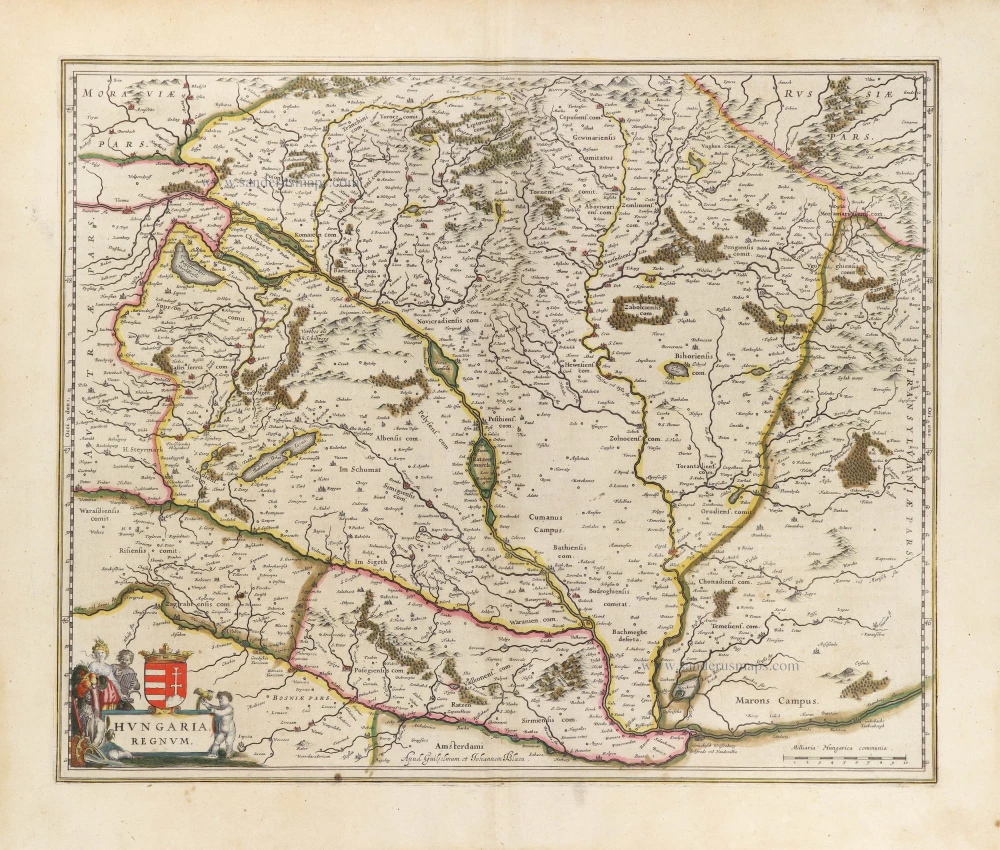
Hungaria Regnum. 1644-45
Hungary, by Willem & Joan Blaeu.
[Item number: 28654]
new

Hungariae Descriptio, Wolfgango Lazio Auct. 1584
Hungary by Abraham Ortelius.
[Item number: 30026]

Hungaria Regnum. 1653
Hungary by Johannes Janssonius.
[Item number: 30410]
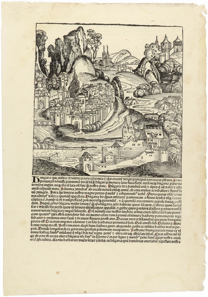
Hungaria CCLXVIII 1493
Fantasy view of Hungary, by Hartmann Schedel.
[Item number: 30954]

Das Königreich Ungarn nebst den angraentzenden Kaeyserlichen Laendern c. 1745.
Hungary by J.G. Schreiber.
[Item number: 31109]

Le Royaume de Hongrie et les Estats qui en ont este Sujets et qui font presentement la partie septentrionale de la Turquie en Europe. 1692
Hungary and Balkans by N. Sanson, so-called published by Hubert Jaillot. (Pirated edition by Pierre Mortier).
[Item number: 31267]

Buda vulgo Offen c. 1690
Budapest: Buda (Hungary) by J. Peeters.
[Item number: 31390]
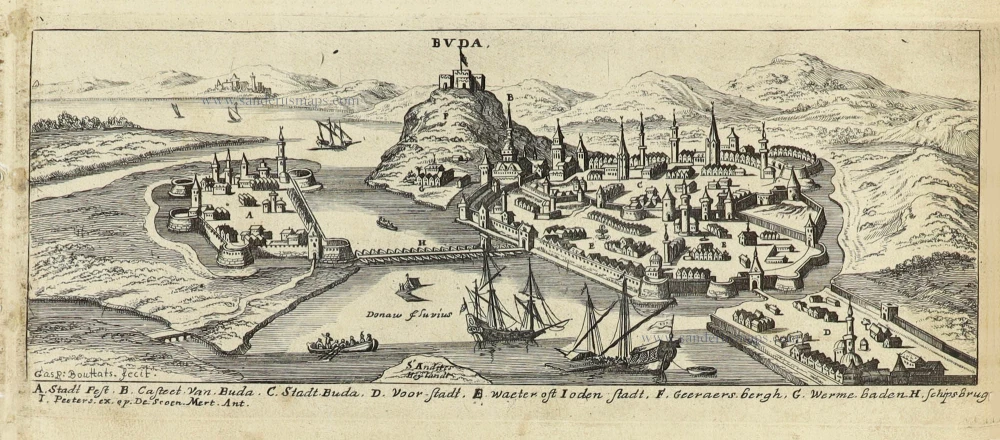
Buda. c. 1690
Budapest: Buda (Hungary) by J. Peeters.
[Item number: 31397]

Hungaria 1618
Hungary by Petrus Bertius, published by Jodocus Hondius II.
[Item number: 31647]
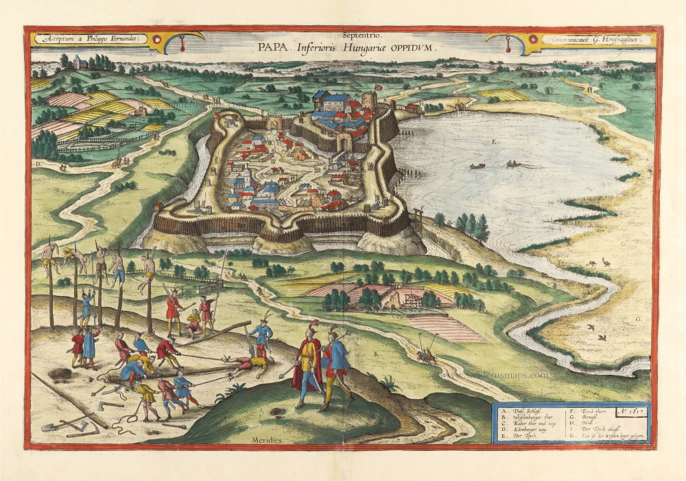
With torture scene. Scarce
Papa, Inferioris Hungariae Oppidum. 1618
Pápa in Hungary, by Georg Braun and Frans Hogenberg, after Georg Hoefnagel.
[Item number: 31782]

Il Regno di Ungheria 1779-1785
Hungary, by Antonio Zatta.
[Item number: 32169]

Rare first state.
Regnorum Hungariae Dalmatiae, Croatiae, Sclavoniae, Bosniae, Serviae et Principatus Transylvaniae c. 1720
Hungary, by J.B. Homann.
[Item number: 32407]

Il Regno d'Ungaria Transilvania, Schivonia, Bosnia, Croatia, Dalmatia; 1687
Western Balkans and Central Europe, by Guillaume Sanson, published by Giovanni de Rossi.
[Item number: 32954]

With interesting text in the margins
Hungaria Regnum. c. 1610-1650
Hungary, by Willem & Joan Blaeu.
[Item number: 33031]