
Mediterranean Sea by Coronelli V.M. (1650-1718) 1691
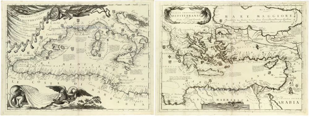
A magnificent and highly decorative two-sheet map of the entire Mediterranean Sea by Vincenzo Maria Coronelli.
The two sheets form a continuous geographical representation extending from the Strait of Gibraltar in the west to the eastern Mediterranean, including the coasts of Spain, France, Italy, the Balkans, Greece, Asia Minor, the Levant and North Africa, together with the numerous islands of the Mediterranean.
The map is particularly remarkable for its exceptionally detailed coastal nomenclature, identifying countless ports, bays, capes, islands and settlements. Numerous explanatory notes provide geographical, historical and maritime information.
The western sheet features a splendid Baroque title cartouche suspended from elaborate drapery. At the same time, a large decorative composition in the lower left incorporates an elephant, an eagle, and the winged lion of Saint Mark supporting a descriptive panel.
The eastern sheet features an elegant title cartouche above Greece, a decorative scale below Egypt and numerous coats of arms identifying important territories and cities.
The detailed representation of the eastern Mediterranean is particularly significant in the context of Venice's maritime interests and its prolonged conflicts with the Ottoman Empire during the late seventeenth century.
One of Coronelli's most impressive maps of the Mediterranean, combining remarkable geographical detail with the elaborate decorative engraving characteristic of Venetian Baroque cartography.
Vincenzo Coronelli (1650-1718)
Vincenzo Coronelli was born in Venice on 16 August 1650 and primarily brought up in Ravenna. He returned to Venice in 1665 and joined the convent of the Minor Conventuals. Five years later, he was sent to Rome to study, and by 1673, he was already a doctor of theology.
Having achieved fame by constructing two globes for the Duke of Parma, he was invited to Paris for three years in 1681 and made two enormous examples for Louis XIV. On his return to Venice, he assiduously collected cartographic material and founded the Academy of the Argonauts. In 1685, he was appointed Cosmographer to the Republic of Venice and authorised to publish a large atlas. He became a geography lecturer at the University of Venice and brought out an Atlante Veneto the following year.
In 1696, he visited Germany, Holland and southern England. During intervals in compiling his vast encyclopaedia, he continued with cartographic projects up to 1709. He died in his native Venice on 9 December 1718.
Coronelli became famous for his globes. In addition, he was a renowned encyclopaedist, mapmaker and geographer. Most of his maps and other material are gathered in his Atlante Veneto (13 vols, 1690-1705). The first volume, subtitled Descrizione generale istorica geografica, was his masterpiece, planned as an extension of Blaeu’s atlas.
Other volumes of the atlas which contain maps are Isolario, two parts (1696-8), with detailed maps and plans, mostly of islands; Corso geografico, two parts based on the edition 1694-7; Libro de’ globi (1697); and Lo Specchio del Mare, a reprint of Levanto's Lo Specchio del Mare Mediterraneo of 1664.
The other vital aspects of his mapping are those arising from the Venetian conquest and his travels. His most extensive military compilation was the Teatro della Guerra, in more than 30 volumes.
Ristretto del Mediterraneo, [set with] Parte Orientale del Mediterraneo ...
Item Number: 33345 new Authenticity Guarantee
Category: Antique maps > Mediterranean Sea
Mediterranean Sea by V. M. Coronelli.
Two maps: the western and eastern parts, not joined.
Title: Ristretto del Mediterraneo, [in set with] Parte Orientale del Mediterraneo ...
Composto Dal P. Maestro Coronelli Cosmografo della Serenissima Republica di Venezia ...
ad uso Dell' Academia Geografica degli Argonauti. Dedicato à Sua Eccell.za
Date of the first edition: c. 1688.
Date of this map: 1691.
Copper engravings, printed on two sheets of paper.
Image size: 455 x 610mm (18 x 24 inches) each.
Sheet size: 475 x 640mm (18¾ x 25¼ inches) each.
Verso: Blank.
Condition: Excellent.
Condition Rating: A+.
From: Atlante Veneto, nel quale si contiene la descrittione... degl' Imperii, Regni, Provincie, e Stati dell' Universo. Venice: Girolamo Albrizzi, 1691. Shirley (Brit.Lib.), T.CORO-7a
A magnificent and highly decorative two-sheet map of the entire Mediterranean Sea by Vincenzo Maria Coronelli.
The two sheets form a continuous geographical representation extending from the Strait of Gibraltar in the west to the eastern Mediterranean, including the coasts of Spain, France, Italy, the Balkans, Greece, Asia Minor, the Levant and North Africa, together with the numerous islands of the Mediterranean.
The map is particularly remarkable for its exceptionally detailed coastal nomenclature, identifying countless ports, bays, capes, islands and settlements. Numerous explanatory notes provide geographical, historical and maritime information.
The western sheet features a splendid Baroque title cartouche suspended from elaborate drapery. At the same time, a large decorative composition in the lower left incorporates an elephant, an eagle, and the winged lion of Saint Mark supporting a descriptive panel.
The eastern sheet features an elegant title cartouche above Greece, a decorative scale below Egypt and numerous coats of arms identifying important territories and cities.
The detailed representation of the eastern Mediterranean is particularly significant in the context of Venice's maritime interests and its prolonged conflicts with the Ottoman Empire during the late seventeenth century.
One of Coronelli's most impressive maps of the Mediterranean, combining remarkable geographical detail with the elaborate decorative engraving characteristic of Venetian Baroque cartography.
Vincenzo Coronelli (1650-1718)
Vincenzo Coronelli was born in Venice on 16 August 1650 and primarily brought up in Ravenna. He returned to Venice in 1665 and joined the convent of the Minor Conventuals. Five years later, he was sent to Rome to study, and by 1673, he was already a doctor of theology.
Having achieved fame by constructing two globes for the Duke of Parma, he was invited to Paris for three years in 1681 and made two enormous examples for Louis XIV. On his return to Venice, he assiduously collected cartographic material and founded the Academy of the Argonauts. In 1685, he was appointed Cosmographer to the Republic of Venice and authorised to publish a large atlas. He became a geography lecturer at the University of Venice and brought out an Atlante Veneto the following year.
In 1696, he visited Germany, Holland and southern England. During intervals in compiling his vast encyclopaedia, he continued with cartographic projects up to 1709. He died in his native Venice on 9 December 1718.
Coronelli became famous for his globes. In addition, he was a renowned encyclopaedist, mapmaker and geographer. Most of his maps and other material are gathered in his Atlante Veneto (13 vols, 1690-1705). The first volume, subtitled Descrizione generale istorica geografica, was his masterpiece, planned as an extension of Blaeu’s atlas.
Other volumes of the atlas which contain maps are Isolario, two parts (1696-8), with detailed maps and plans, mostly of islands; Corso geografico, two parts based on the edition 1694-7; Libro de’ globi (1697); and Lo Specchio del Mare, a reprint of Levanto's Lo Specchio del Mare Mediterraneo of 1664.
The other vital aspects of his mapping are those arising from the Venetian conquest and his travels. His most extensive military compilation was the Teatro della Guerra, in more than 30 volumes.
Related items

Tafel der Lender darin der Apostel Paulus geprediget hat. 1581
Eastern part of the Mediterranean Sea, by Heinrich Bünting.
[Item number: 2530]

Nieuwe Pascaart voor een Gedeelte van de Zeekusten van Barbaria Beginnende van C. Mesurata tot Caap Rusato Als mede de West-kust van Candia. 1697-1709
Sea chart of the coasts of Morocco, by Johannes Van Keulen.
[Item number: 6506]

Lumen Historiarum per Occidentem. . . . 1624
Europe - Western Mediterranean Sea, by A. Ortelius.
[Item number: 26573]

Geografische Beschryvinghe van de Wandeling der Apostelen ende De Reysen Pauli, Mitsgaders de Landen ende Rijcken daer sij het Evangelium eerst hebben verkondight. ... c. 1664
Eastern Mediterranean Sea, by Nicolaes Visscher I.
[Item number: 27590]

La Mer Mediterranee Divisee en ses Principales Parties ou Mers. c. 1705
Mediterranean Sea by N. Sanson, published by Pieter (Pierre) Mortier.
[Item number: 27767]

Mediteraneo e Colfo de Setelia. c. 1604
Eastern Mediterranean Sea by Jean Zuallart.
[Item number: 28484]

Iesu Christi salvatoris nostri apostolorum Petri, et Pauli mansiones, itinera, peregrinationes &c. per Galilaeam, Samariam, Iudaeam, et per Aegyptum, Asiam, Europam. 1665
Eastern Mediterranean by Nicolas Sanson.
[Item number: 30044]
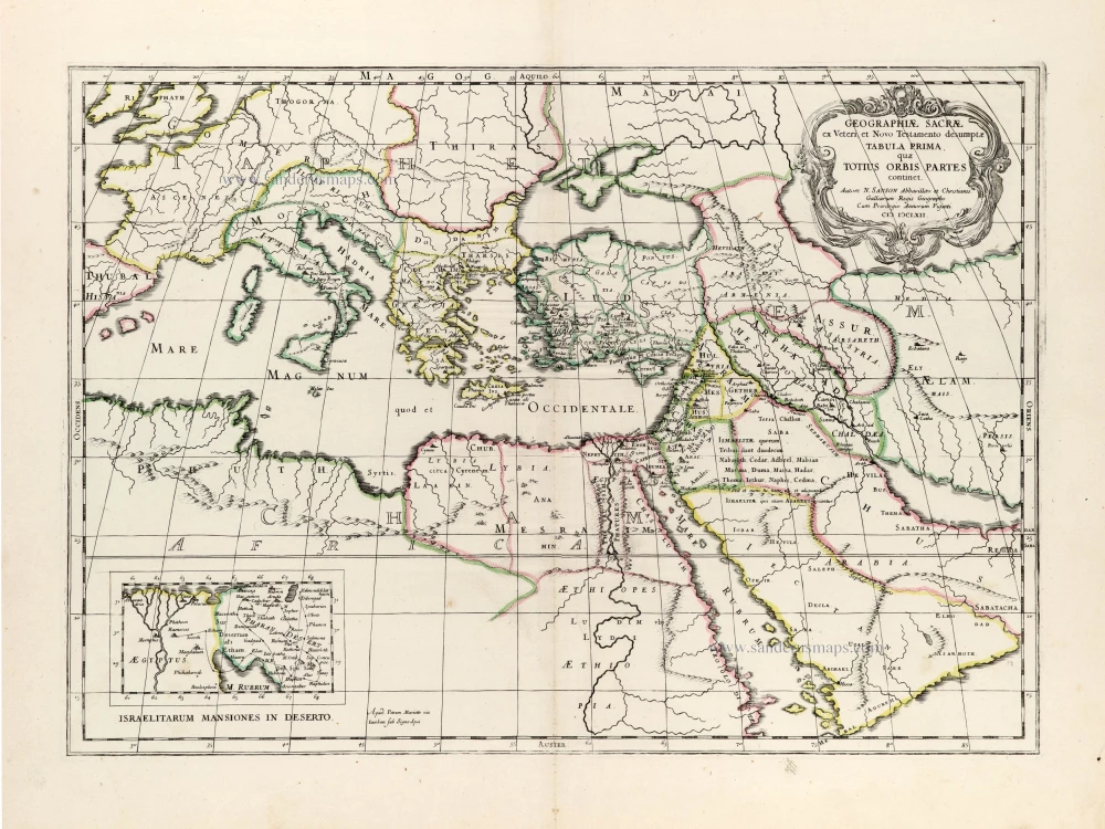
Geographiae Sacrae ex Veteri et Novo Testamento desumptae Tabula Prima, quae Totius Orbis Partet continet. 1665
Eastern Mediterranean by Nicolas Sanson, published by Pierre Mariette.
[Item number: 30075]

Superb old colouring, heightened with gold.
Geografische Beschryvinghe van de Wandeling der Apostelen ende De Reysen Pauli, Mitsgaders de Landen ende Rijcken daer sij het Evangelium eerst hebben verkondight. ... 1663
Eastern Mediterranean Sea, by Nicolaes Visscher I.
[Item number: 30537]
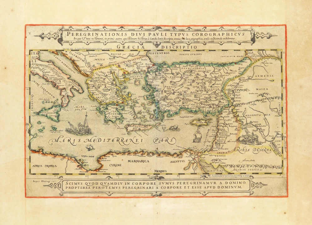
Rare map showing the peregrinations of St. Paul.
Peregrinationis Divi Pauli Typus Corographicus In quo & novi testamenti, in primis autem apostulorum historiae, à Sancto Luca descriptae, omnia fere loca geographica, oculis inspicienda exhibentur. c. 1630-1650
The peregrinations of St. Paul in the Eastern Mediterranean, by Jacques Honervogt after Abraham Ortelius.
[Item number: 30854]

Superb old colouring, heightened with gold.
Description Geogaphique des voyages de St. Paul et des autres Apostres; avec celle des Païs & Royaumes ou ils ont presché l'Evangile. 1663
Eastern Mediterranean, by Nicolaes Visscher I.
[Item number: 31040]