
Old antique chart of the Pacific Ocean by J. Janssonius 1650
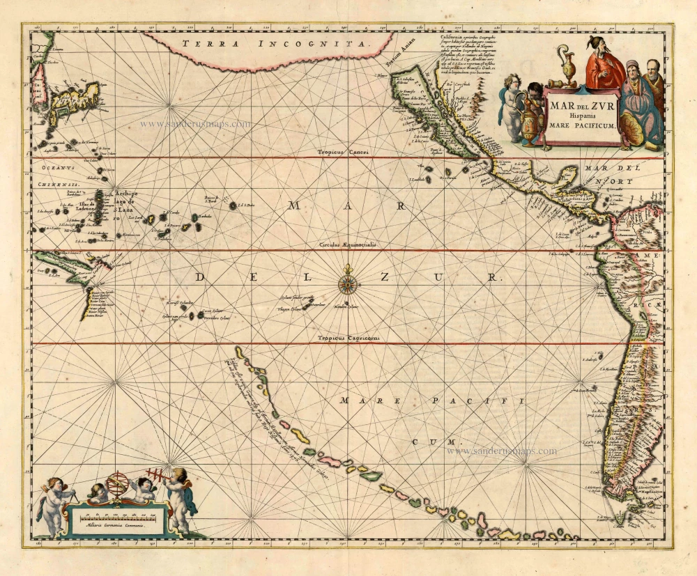
In 1650 Joannes Janssonius published the sea atlas as the fifth volume of his Atlas Novus. It was the first of its kind intended for a general market. This particular chart is the first of the whole of the Pacific Ocean. The north of the Pacific Ocean is dominated by a Terra Incognita; this land mass had been a common feature of the region for some time. One of the most interesting features is the chain of islands threading their way across the southern Pacific. A legend identifies them as being discovered by one Hernando Galego in 1576, who was sent at the behest of the King of Spain. The recently discovered coastlines of southern New Guinea and Cape York, Australia, also appear.
The Janssonius Family
Joannes Janssonius (Arnhem, 1588-1664), son of the Arnhem publisher Jan Janssen, married Elisabeth Hondius, daughter of Jodocus Hondius, in Amsterdam in 1612. After his marriage, he settled down in this town as a bookseller and publisher of cartographic material. In 1618, he established himself in Amsterdam next door to Blaeu’s bookshop. He entered into serious competition with Willem Jansz. Blaeu when copying Blaeu’s Licht der Zeevaert after the expiration of the privilege in 1620. His activities concerned the publication of atlases, books, single maps, and an extensive book trade with branches in Frankfurt, Danzig, Stockholm, Copenhagen, Berlin, Koningsbergen, Geneva, and Lyon. In 1631, he began publishing atlases together with Henricus Hondius.
In the early 1640s, Henricus Hondius left the atlas publishing business to Janssonius. Competition with Joan Blaeu, Willem’s son and successor, in atlas production, prompted Janssonius to enlarge his Atlas Novus finally into a work of six volumes, into which a sea atlas and an atlas of the Old World were inserted. Other atlases published by Janssonius are Mercator’s Atlas Minor, Hornius’s historical atlas (1652), the townbooks in eight volumes (1657), Cellarius’s Atlas Coelestis and several sea atlases and pilot guides.
After the death of Joannes Janssonius, the shop and publishing firm were continued by the heirs under the direction of Johannes van Waesbergen (c. 1616-1681), son-in-law of Joannes Janssonius. Van Waesbergen added Janssonius's name to his own.
In 1676, Joannes Janssonius’s heirs sold by auction “all the remaining Atlases in Latin, French, High and Low German, as well as the Stedeboecken in Latin, in 8 volumes, bound and unbound, maps, plates belonging to the Atlas and Stedeboecken.” The copperplates from Janssonius’s atlases were afterwards sold to Schenk and Valck.
Mar del Zur Hispanis Mare Pacificum.
Item Number: 25213 Authenticity Guarantee
Category: Antique maps > Oceans
Old, antique chart of the Pacific Ocean by J. Janssonius.
First state. Insular California.
Date of the first edition: 1650
Date of this map: 1650
Copper engraving
Size: 54.5 x 58cm (21.1 x 22.5 inches)
Verso text: Latin
Condition: Contemporary old coloured, upper centrefold reinforced, upper margin bit frayed.
Condition Rating: A
References: Burden, 292, State 1; Van der Krogt 1, 0600:1; McLaughlin, 11; Clancy, p.84 Map 6.16.
From: Atlantis Majoris Quinta Pars, Orbem Maritimum seu Omnium Marium totius Orbis Terrarum Navigationibus hodierno tempore frequentatorum descriptionem accuratissimam continens; ... Amsterdam, J. Janssonius, 1650. (Van der Krogt 1, 404.5M)
In 1650 Joannes Janssonius published the sea atlas as the fifth volume of his Atlas Novus. It was the first of its kind intended for a general market.
This particular chart is the first of the whole of the Pacific Ocean. The north of the Pacific Ocean is dominated by a Terra Incognita; this land mass had been a common feature of the region for some time.
One of the most interesting features is the chain of islands threading their way across the southern Pacific. A legend identifies them as being discovered by one Hernando Galego in 1576, who was sent at the behest of the King of Spain. The recently discovered coastlines of southern New Guinea and Cape York, Australia, also appear.
In 1650 Joannes Janssonius published the sea atlas as the fifth volume of his Atlas Novus. It was the first of its kind intended for a general market. This particular chart is the first of the whole of the Pacific Ocean. The north of the Pacific Ocean is dominated by a Terra Incognita; this land mass had been a common feature of the region for some time. One of the most interesting features is the chain of islands threading their way across the southern Pacific. A legend identifies them as being discovered by one Hernando Galego in 1576, who was sent at the behest of the King of Spain. The recently discovered coastlines of southern New Guinea and Cape York, Australia, also appear.
The Janssonius Family
Joannes Janssonius (Arnhem, 1588-1664), son of the Arnhem publisher Jan Janssen, married Elisabeth Hondius, daughter of Jodocus Hondius, in Amsterdam in 1612. After his marriage, he settled down in this town as a bookseller and publisher of cartographic material. In 1618, he established himself in Amsterdam next door to Blaeu’s bookshop. He entered into serious competition with Willem Jansz. Blaeu when copying Blaeu’s Licht der Zeevaert after the expiration of the privilege in 1620. His activities concerned the publication of atlases, books, single maps, and an extensive book trade with branches in Frankfurt, Danzig, Stockholm, Copenhagen, Berlin, Koningsbergen, Geneva, and Lyon. In 1631, he began publishing atlases together with Henricus Hondius.
In the early 1640s, Henricus Hondius left the atlas publishing business to Janssonius. Competition with Joan Blaeu, Willem’s son and successor, in atlas production, prompted Janssonius to enlarge his Atlas Novus finally into a work of six volumes, into which a sea atlas and an atlas of the Old World were inserted. Other atlases published by Janssonius are Mercator’s Atlas Minor, Hornius’s historical atlas (1652), the townbooks in eight volumes (1657), Cellarius’s Atlas Coelestis and several sea atlases and pilot guides.
After the death of Joannes Janssonius, the shop and publishing firm were continued by the heirs under the direction of Johannes van Waesbergen (c. 1616-1681), son-in-law of Joannes Janssonius. Van Waesbergen added Janssonius's name to his own.
In 1676, Joannes Janssonius’s heirs sold by auction “all the remaining Atlases in Latin, French, High and Low German, as well as the Stedeboecken in Latin, in 8 volumes, bound and unbound, maps, plates belonging to the Atlas and Stedeboecken.” The copperplates from Janssonius’s atlases were afterwards sold to Schenk and Valck.
Related items
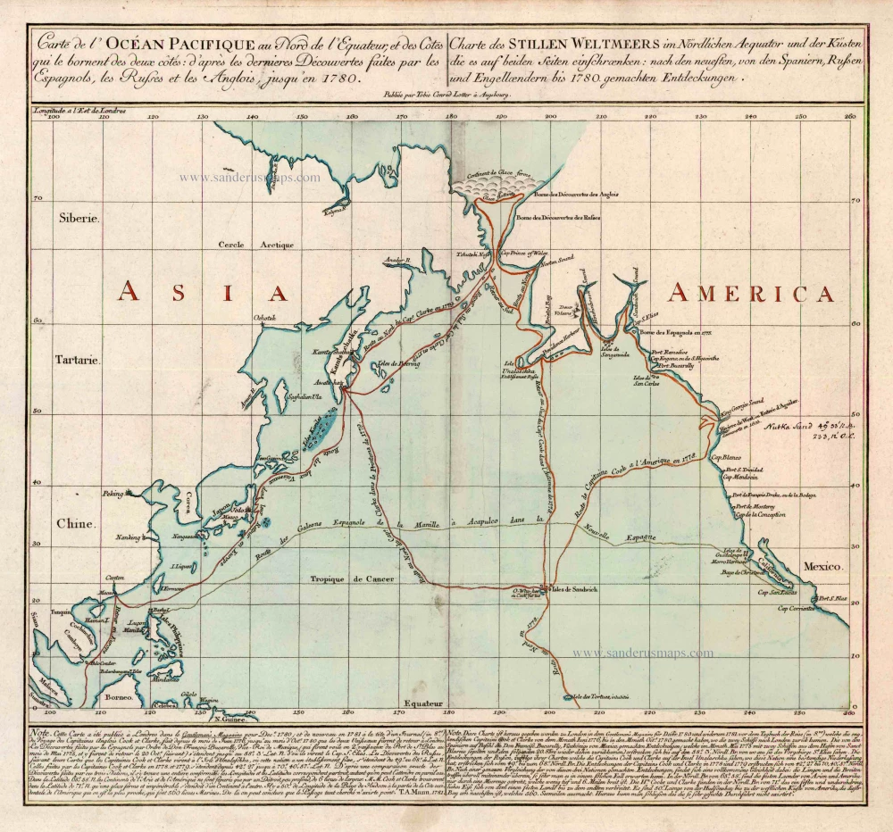
Carte de l'Ocean Pacifique au Nord de l'Equateur, et des Cotes qui le Bornent des Deux Cotes: D'Apres les Dernieres Decouvertes Faites par les Espagnols, les Russes et les Anglois, jusqu'en 1780. 1780
The Northern Pacific Ocean, by T.C. Lotter.
[Item number: 11984]

Caerte van de zeylage van Jacob le Maire over de Zuydzee, vertonende de Eylanden ende Landen aldaer by hem ghesien ende aenghedaen. / Tabula, ductum navigationis, quem in Mari Australi tenuit Iacobus Le Maire ... 1622
Rare chart showing the route taken by Schouten and le Maire from South America to New Guinea, by Michiel Colijn.
[Item number: 25104]
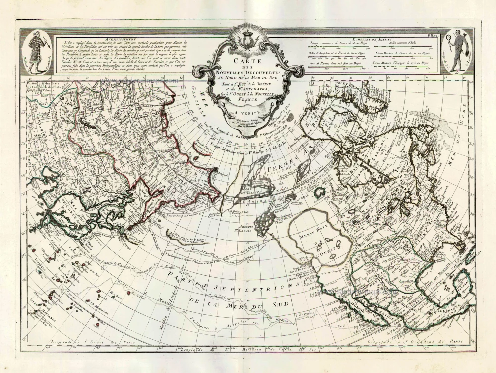
Carte des Nouvelles Decouvertes au Nord de la Mer du Sud, tant à l'Est de la Sibérie et du Kamtchatka, qu'à l'Ouest de la Nouvelle France. 1776-79
Pacific Ocean (North) by Francesco & Paolo Santini
[Item number: 26979]
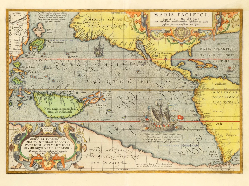
Maris Pacifici, (quod vulgo Mar del Zur) cum regionibus circumiacentibus, insulisque in codem passim sparsis, novissima descriptio. 1601
Pacific Ocean by Abraham Ortelius.
[Item number: 28744]