
The only Spanish edition of Doncker's sea-atlas
Title page of Hendrick Doncker's sea-atlas 1669

The title page to Doncker's Zee-Atlas consists of three panels. In the centre, two buxom, scantily dressed maidens support the drapery, which reveals the title. One holds a cross-staff; the other, a portable mariner's astrolabe. At the top is a globe above which Atlas, in a half-kneeling position, holds up the heavens. In the background, a panoramic flotilla of ships can be seen in full sail.
The bottom panel has a group of putti frolicking around an anchored buoy and playing with various navigational instruments. Also in the scene to the right is a suckling mermaid and, to the left, a bearded merman who is having his drinking horn emptied over his head by a particularly sad or drunken putto. Doncker's design must have enjoyed himself constructing such a light-hearted scene, unaware that the English map-maker and publisher Philip Lea was to copy Doncker's design in reverse in about 1689 and reprint it over the next forty years.
Hendrick Doncker (1625-1699)
Hendrick Doncker became a member of the bookseller's guild in 1647 and ran his shop successfully for fifty years. He was able to develop one of the most popular sets of maritime works published in Amsterdam during the Golden Age.
In 1651 he bought a house in the Nieuwe Brugsteeg in Amsterdam. It was called 'in 't Stuurmans gereetschap' (in the mariners' instruments) and stood opposite the house where Johannes van Keulen later settled.
Apart from the sea atlases, charts and pilot books, Hendrik Doncker published various editions of textbooks on the art of navigation.
After the death of Hendrick Doncker, the son, Hendrick II (c. 1664-c.1739), continued publishing the sea atlases Zeeatlas and Zeespiegel until 1708.
Doncker's charts were the most up-to-date in the second half of the 17th century. Although there is some similarity to those charts published by Van Loon, Goos, Lootsman, and Doncker, the latter's charts are original.
In 1655, Hendrick Doncker had begun with the publication of a pilot guide, the Lichtende Columne ofte Zeespiegel. In 1659 he published his first sea atlas, the Zee-Atlas of Waeter-waereld, with 19 maps. Between 1659 and 1669, he increased the number of charts from 19 to 30 and in 1669 he came with an edition containing 50, which was soon to be followed by an edition with large maps: the Nieuwe Groote Vermeerderde Zeeatlas, also with 50 charts. This beautiful atlas was reprinted and continually improved for more than 25 years. After the death of Hendrick Doncker in 1699, his son continued the publication and even enlarged and enhanced the sea-atlas.
La Atlas del Mundo o El Mundo Aguado Enseña Todas las Entradas de los puertos y de las Costas halladas y conosidas del Mundo.
Item Number: 33153 new Authenticity Guarantee
Category: Antique maps > Title Pages
Title page of Hendrick Doncker's Zee-Atlas - Water World.
Title: La Atlas del Mundo o El Mundo Aguado Enseña Todas las Entradas de los puertos y de las Costas halladas y conosidas del Mundo.
En Amsterdam, Con Henricque Doncquer, Vendedor de Libroz, en el Señal del Graetboogmaquer, en la Calle primera pasanda la Puenta Nueva, [1669].
Date: 1669.
Copper engraving, printed on paper.
Image size: 370 x 215mm (14½ x 8½ inches).
Sheet size: 450 x 280mm (17¾ x 11 inches).
Verso: Spanish text.
Condition: Original coloured, excellent.
Condition Rating: A.
From: La Atlas del Mundo o El Mundo Aguado Enseña Todas las Entradas de los puertos y de las Costas halladas y conosidas del Mundo. Amsterdam, H. Doncker, 1669.
The title page to Doncker's Zee-Atlas consists of three panels. In the centre, two buxom, scantily dressed maidens support the drapery, which reveals the title. One holds a cross-staff; the other, a portable mariner's astrolabe. At the top is a globe above which Atlas, in a half-kneeling position, holds up the heavens. In the background, a panoramic flotilla of ships can be seen in full sail.
The bottom panel has a group of putti frolicking around an anchored buoy and playing with various navigational instruments. Also in the scene to the right is a suckling mermaid and, to the left, a bearded merman who is having his drinking horn emptied over his head by a particularly sad or drunken putto. Doncker's design must have enjoyed himself constructing such a light-hearted scene, unaware that the English map-maker and publisher Philip Lea was to copy Doncker's design in reverse in about 1689 and reprint it over the next forty years.
Hendrick Doncker (1625-1699)
Hendrick Doncker became a member of the bookseller's guild in 1647 and ran his shop successfully for fifty years. He was able to develop one of the most popular sets of maritime works published in Amsterdam during the Golden Age.
In 1651 he bought a house in the Nieuwe Brugsteeg in Amsterdam. It was called 'in 't Stuurmans gereetschap' (in the mariners' instruments) and stood opposite the house where Johannes van Keulen later settled.
Apart from the sea atlases, charts and pilot books, Hendrik Doncker published various editions of textbooks on the art of navigation.
After the death of Hendrick Doncker, the son, Hendrick II (c. 1664-c.1739), continued publishing the sea atlases Zeeatlas and Zeespiegel until 1708.
Doncker's charts were the most up-to-date in the second half of the 17th century. Although there is some similarity to those charts published by Van Loon, Goos, Lootsman, and Doncker, the latter's charts are original.
In 1655, Hendrick Doncker had begun with the publication of a pilot guide, the Lichtende Columne ofte Zeespiegel. In 1659 he published his first sea atlas, the Zee-Atlas of Waeter-waereld, with 19 maps. Between 1659 and 1669, he increased the number of charts from 19 to 30 and in 1669 he came with an edition containing 50, which was soon to be followed by an edition with large maps: the Nieuwe Groote Vermeerderde Zeeatlas, also with 50 charts. This beautiful atlas was reprinted and continually improved for more than 25 years. After the death of Hendrick Doncker in 1699, his son continued the publication and even enlarged and enhanced the sea-atlas.
Related items

Atlas Novus - Atlas-Nouveau Contenant toutes les parties du Monde &c. 1733
Atlas title page, by Covens & Mortier.
[Item number: 12544]

Toonneel des Aerdrycx, oft Nieuwe Atlas, uytgegeven door Wilhelm en Joan Blaeu. Vierde Deel. 1642-43
Atlas title page for the Blaeu Atlas of England
[Item number: 16772]

Toonneel des Aerdrycx, oft Nieuwe Atlas, uytgegeven door Wilhelm en Joan Blaeu. Eerste Deels Tweede Stuck. 1642-43
Atlas Title Page, by Blaeu W. & J.
[Item number: 21455]

Sevende Stuck der Aerdrycks-Beschryving, welck vervat Italien en Griecken. 1664-65
Atlas Title Page by J. Blaeu
[Item number: 21621]

Heightened in gold
De Groote Nieuwe Vermeerderde Zee-Atlas ofte Water-Werelt. Vertoonende in sigh alle de Zee-Kusten des Aardtryks, ... 1693
Johannes Van Keulen, sea atlas title page.
[Item number: 26447]

Atlas Minor Sive totius Orbis Terrarum contracta delineat(a) ex conatibus Nic(olaus) Visscher ... 1683-1702
Allegoric title page of the Atlas Minor, by Nicolaas Visscher II.
[Item number: 27022]

Rare
Africa. 1725-50.
Allegorical title page of Africa by Joan Blaeu, published by Reinier & Josua Ottens.
[Item number: 28506]

Rare. Alegorical title of America.
America. 1725-50.
Title page by Joan Blaeu, published by Reinier & Josua Ottens.
[Item number: 28507]

Atlas. 1725-50.
Allegorical title page by Joan Blaeu, published by Reinier & Josua Ottens.
[Item number: 28509]

Heightened in gold
Atlas Minor Sive totius Orbis Terrarum contracta delinea... 1683-1716
Allegorical atlas title page by Nicolaas Visscher II.
[Item number: 28787]

Gallia, quae est Europae Liber XIV. 1640-43
Title page for the France section of Blaeu's
[Item number: 28998]

Title page by A. Dürer
Claudii Ptolemaei Geographiae Enarrationis libro octo ... 1525
Lorenz Fries' Ptolemy Atlas.
[Item number: 29251]
Rare Atlas Major title.
Europa. 1662
Title Page by Joan Blaeu.
[Item number: 29731]
Exceptional nice old colour. Heightened in gold.
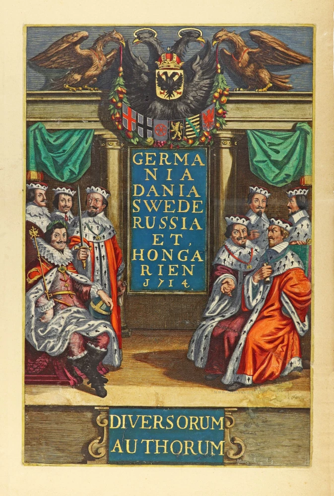
Germania Dania Swede Russia et Hongarien 1714. - Diversorum Authorum. 1714
Joannes Janssonius, title page
[Item number: 30095]
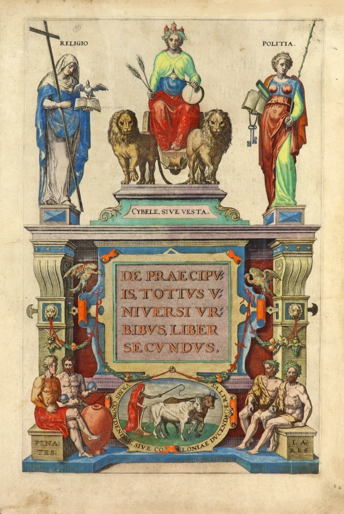
De Praecipuis, Totius Universi Urbibus Liber Secundus. 1575-1612
Georg Braun & Frans Hogenberg, allegorical atlas title page of the second part.
[Item number: 30096]

Nouveau Theatre du Monde ou Nouvel Atlas comprenant Les Tables et Descriptions de toutes les Regions de la Terre. 1641
Frontispiece by Hondius Henricus
[Item number: 30116]
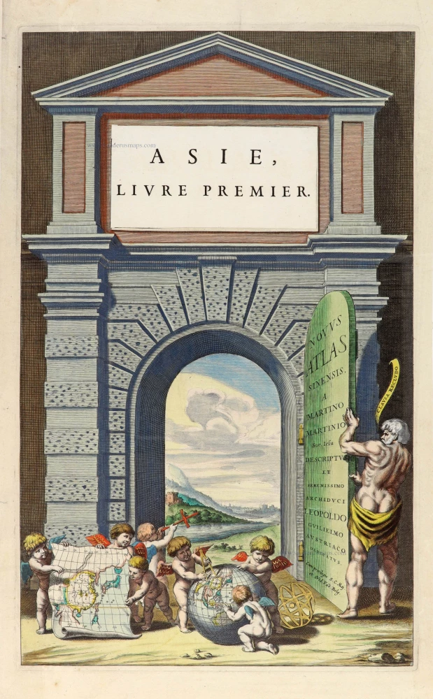
Novus Atlas Sinensis a Martino Martinio Soc. Iesu Descriptus et Serenissimo Archiduci Leopoldo Guilielmo Austriaco Dedicatus. 1655
Title page for Blaeu's atlas of China as part of the Theatrum Orbis Terrarum.
[Item number: 30153]
![Linschoten's <i>Voyagie, ofte Schip-Vaert</i> Anno 1594 en[de] 1595. With inset of Yugor Strait.](https://sanderusmaps.com/assets/IMG/webp/m30292.webp)
Title page of the first edition of Linschoten's Arctic voyages in search of the North-East Passage to China.
Voyagie, ofte Schip-Vaert, van Ian Huyghen van Linschoten 1601
Linschoten's Voyagie, ofte Schip-Vaert Anno 1594 en[de] 1595. With inset of Yugor Strait.
[Item number: 30292]

N: Visscheri Germania Inferior Sive XVII Provinciarum Geographicae Generales ut et Particulares Tabulae. - Kaert-Boeck van de XVII Nederlandtsche Provincien, Nieuwlycx uytgegeven door Nicolaes Visscher. After 1677 (privilege)
Atlas title page by Nicolas Visscher II.
[Item number: 30417]

In rare original colour. - Complete set of frontispieces of the Atlas Historique
1713-1719
Zacharias Châtelain, allegorical title pages (5)
[Item number: 31448]

Rare title page of Purchas's Pilgrimes, with his portrait and worldmap
Hakluytus Posthumus, or Purchas His Pilgrimes 1625
Samuel Purchas ' title page with a world map and portrait
[Item number: 32417]

Le Nouveau & Grand Illuminant Flambeau de la Mer. 1684
Title page by Johannes Van Keulen
[Item number: 32472]

Superb colouring
Theatrum Orbis Terrarum. 1579
Title Page by Ortelius Abraham.
[Item number: 32516]

Beautiful original coloured
Parergon, cioe fuor d'Opera, et Giunta, overo alcune tavole dell'antica Geografia. 1612.
Atlas Title Page of the Parergon, by Abraham Ortelius.
[Item number: 32517]

Spectacular title page
Atlas Maior. 1706
Title page of Frederick de Wit's Atlas Maior, published by Christophorum Browne.
[Item number: 32532]

The most desirable of Dutch atlas title pages
Joannis Janssonii Atlas Contractus 1666
Frontispiece of Joannes Jansonius' Atlas Contractus.
[Item number: 32581]

No title 1715
Joannes van Keulen, Allegoric title page - frontispiece to part IV of the Zee-Fakkel
[Item number: 32607]

Famous frontispiece by Romeyn de Hooghe
Atlas Maritime 1693
Title page of Pierre Mortier's Atlas Maritime
[Item number: 32627]

Heightened in gold
De Historien van het Oude en Nieuwe Testament in konst prenten uitgebeeld door den heer en mr. R. de Hooghe. 1721
Title page of Basnages' 't Groot Waerelds Tafereel
[Item number: 32851]

Parergon, Sive Veteris Geographiae aliquot Tabulae. 1612
Title page of Ortelius' Parergon.
[Item number: 32852]

Rare first edition
Reys-Gheschrift Vande Navigatien der Portugaloysters in Orienten inhoudende de Zeevaert soo van Portugael naer Oost Indien als van Oost Indien weder naer Portugael ... 1595
Title page of Linschoten's first edition of his Itinerarium
[Item number: 33009]

Scarce frontispiece of Maria Sibylla Merian METAMORPHOSIS on Surinamese insects.
Recueil de Plantes de Suriname. 1771
Title page of M.S. Merian, Recueil de Plantes de Suriname.
[Item number: 33012]

A uniform set of frontispieces for the Zeefakkel. Excellent condition
[No title] 1709
Allegoric title pages of van Keulen's Zeefakkel.
[Item number: 33019]

Isolario dell' Atlante Veneto del P. Coronelli. 1692-96
Title pages of Coronelli's Isolario. - Two sheets
[Item number: 33073]
new

Atlas. c. 1680
Atlas Title Page by Frederick de Wit.
[Item number: 33152]
new