
Old antique maps of the Arctic and Antarctic by V.M. Coronelli. 1691-92


Vincenzo Coronelli (1650-1718)
Vincenzo Coronelli was born in Venice on 16 August 1650 and primarily brought up in Ravenna. He returned to Venice in 1665 and joined the convent of the Minor Conventuals. Five years later, he was sent to Rome to study, and by 1673, he was already a doctor of theology.
Having achieved fame by constructing two globes for the Duke of Parma, he was invited to Paris for three years in 1681 and made two enormous examples for Louis XIV. On his return to Venice, he assiduously collected cartographic material and founded the Academy of the Argonauts. In 1685, he was appointed Cosmographer to the Republic of Venice and authorised to publish a large atlas. He became a geography lecturer at the University of Venice and brought out an Atlante Veneto the following year.
In 1696, he visited Germany, Holland and southern England. During intervals in compiling his vast encyclopaedia, he continued with cartographic projects up to 1709. He died in his native Venice on 9 December 1718.
Coronelli became famous for his globes. In addition, he was a renowned encyclopaedist, mapmaker and geographer. Most of his maps and other material are gathered in his Atlante Veneto (13 vols, 1690-1705). The first volume, subtitled Descrizione generale istorica geografica, was his masterpiece, planned as an extension of Blaeu’s atlas.
Other volumes of the atlas which contain maps are Isolario, two parts (1696-8), with detailed maps and plans, mostly of islands; Corso geografico, two parts based on the edition 1694-7; Libro de’ globi (1697); and Lo Specchio del Mare, a reprint of Levanto's Lo Specchio del Mare Mediterraneo of 1664.
The other vital aspects of his mapping are those arising from the Venetian conquest and his travels. His most extensive military compilation was the Teatro della Guerra, in more than 30 volumes.
[no title]
Item Number: 25776 Authenticity Guarantee
Category: Antique maps > World
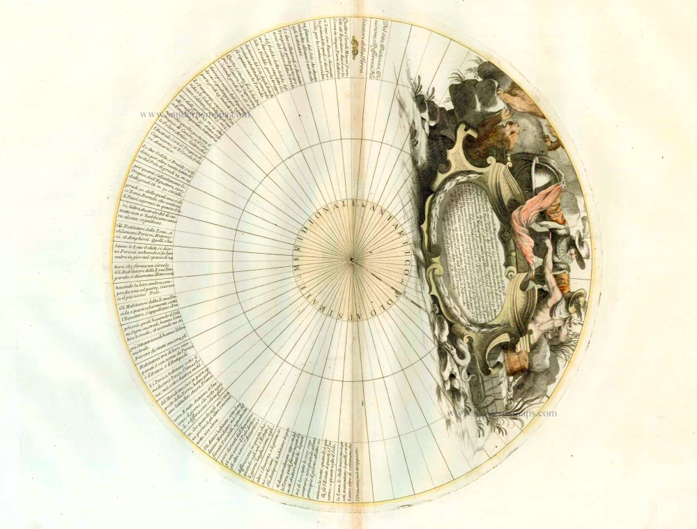
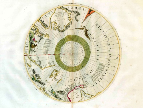
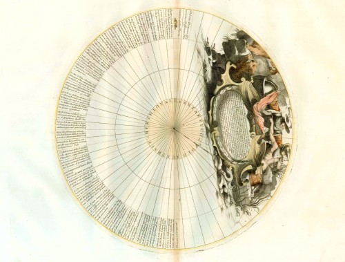
Two old, antique maps of the North and South Pole, by Vincenzo Coronelli.
The North and South Polar calottes for the 42" globe.
Shows the North Pole with the coasts of Canada, Greenland, Scandinavia and Siberia, and is decorated with pictorial scenes of bear, seal and whale hunters.
Date of the first edition: 1688
Date of this map: 1691-99
Copper engraving
Size each (= diameter, not including margins): 37 x 37cm (14.4 x 14.4 inches)
Verso: Blank
Condition: Original coloured, excellent.
Condition Rating: A+
References: Kershaw, 169; Hinrichsen, 127.
From: Corso Geografico Universelle. Venice, 1691-92 (or later editions of Coronelli's atlases at the end of the 17th century).
These two maps appear to be close derivatives of the Jansson-Blaeu maps of the arctic, with suitable decorative embellishments coupled to some small changes. Coronelli elected to follow the Dutch interpretation of arctic Canada, but added a single waterway almost linking Hudson Strait with Cumberland Strait, possibly as a compromise to the Sanson version. To the east of Spitzbergen, Coronelli has added "Terra di Wiches" from an unknown source, but he also has partially accepted the changes incorporated in the Visscher 1684 edition, Nova et Accurata Poli Arctici, where the northern tip of "Nova Zemla" is joined to mainland Russia. (Kershaw)
"In the early 1680s Vincenzo Coronelli constructed two vast globes - terrestrial and celestial - over fifteen feet in diameter for Louis XIV. These globes were drawn and painted by hand, whereas Coronelli's globes of 1688 were based on printed gores of which sets are extant in the British Library and Library of Congress. They represent a globe of 110 centimetres in diameter: one of the largest based on printed gores hitherto. The polar calottes were printed separately.
The engraving and design throughout is of the highest standard with neat contrasting lettering and five large cartouches of singular grace and elegance. . . ." (Shirley)
These gores and calottes were printed separately in 1688 for the construction of the globes. Some of the half-gores from the 1688 plates were reprinted in the 1696-97 edition of his Isolario and later in his Libro dei Globi with the dedication redated 1699. Pages from these works are thus available to collectors. According to Kershaw, the calottes appeared already in Coronelli's Corso Geografico, 1691-92.
Vincenzo Coronelli (1650-1718)
Vincenzo Coronelli was born in Venice on 16 August 1650 and primarily brought up in Ravenna. He returned to Venice in 1665 and joined the convent of the Minor Conventuals. Five years later, he was sent to Rome to study, and by 1673, he was already a doctor of theology.
Having achieved fame by constructing two globes for the Duke of Parma, he was invited to Paris for three years in 1681 and made two enormous examples for Louis XIV. On his return to Venice, he assiduously collected cartographic material and founded the Academy of the Argonauts. In 1685, he was appointed Cosmographer to the Republic of Venice and authorised to publish a large atlas. He became a geography lecturer at the University of Venice and brought out an Atlante Veneto the following year.
In 1696, he visited Germany, Holland and southern England. During intervals in compiling his vast encyclopaedia, he continued with cartographic projects up to 1709. He died in his native Venice on 9 December 1718.
Coronelli became famous for his globes. In addition, he was a renowned encyclopaedist, mapmaker and geographer. Most of his maps and other material are gathered in his Atlante Veneto (13 vols, 1690-1705). The first volume, subtitled Descrizione generale istorica geografica, was his masterpiece, planned as an extension of Blaeu’s atlas.
Other volumes of the atlas which contain maps are Isolario, two parts (1696-8), with detailed maps and plans, mostly of islands; Corso geografico, two parts based on the edition 1694-7; Libro de’ globi (1697); and Lo Specchio del Mare, a reprint of Levanto's Lo Specchio del Mare Mediterraneo of 1664.
The other vital aspects of his mapping are those arising from the Venetian conquest and his travels. His most extensive military compilation was the Teatro della Guerra, in more than 30 volumes.