
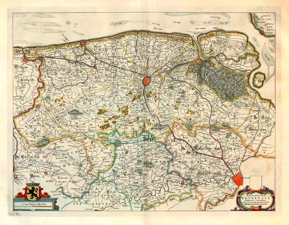
West-Vlaanderen (East), by Henricus Hondius. 1641
The Hondius Family
Jodocus Hondius the Elder (1563-1612)
Joost d’Hondt was born at Wakken (Flanders) in 1563. Two years later, his family settled in Ghent, where young Joost displayed an excellent gift for drawing and calligraphy. Through study and lessons, he developed his talents and became an engraver with a good reputation.
Due to the circumstances of the war, he moved to London in 1584, where he settled down as an engraver, instrument-maker, and map-maker. In 1587, he married Coletta van den Keere, sister of the well-known engraver Pieter van den Keere (Petrus Kaerius); some years earlier, his sister, Jacomina, had married Pieter van den Berghe (Petrus Montanus). Joost, who had Latinized his name to Jodocus Hondius, closely co-operated with his two brothers-in-law.
The political situation in the Northern Netherlands in 1593 was such that Jodocus seemed justified in establishing himself in Amsterdam, where many Antwerp printers, publishers, and engravers had gone. In this new centre of cartography, Jodocus Hondius set up his business “In de Wackere Hondt” (in the vigilant dog), this name being an allusion to his birthplace and name. He engraved many maps and published atlases and many other works, such as his continuation of Gerard Mercator’s Atlas.
He suddenly passed away in February 1612. The publishing firm of Jodocus Hondius was continued by his widow, later on, by his two sons, Jodocus Jr. and Henricus, and by his son-in-law, J. Janssonius.
Jodocus Hondius II (1594-1629) & Henricus Hondius (1597-1651)
After the father’s death, the widow and her seven children continued publishing the atlases under the name of Jodocus Hondius till 1620. The firm was reinforced by the very welcome help of Joannes Janssonius (1588-1664), who married 24-year-old Elisabeth Hondius in 1612. After 1619, Mercator’s Atlas was published under the name of Henricus Hondius.
One of the most dramatic events in the early history of commercial cartography in Amsterdam was the sale of Jodocus Hondius Jr.’s copper plates to Willem Jansz. Blaeu in 1629, the year of his death. At least 34 plates, from which Jodocus II had printed single-sheet maps for his benefit, passed into the hands of his great competitor. Immediately after that, his brother, Henricus, and Joannes Janssonius ordered the engraving of identical plates.
Henricus devoted all his energy to publishing the Atlas for an extended period. He saw its growth up to and including the fourth part in 1646; after that, his name no longer figures on the title pages. After 1638, the title of the Atlas was changed to Atlas Novus; Joannes Janssonius mainly carried it on.
The competition with the Blaeu's dates from 1630. In 1630, Willem Janszoon (=Blaeu) first attacked with his Atlantis Appendix. In 1635, Blaeu completed his Theatrum Orbis Terrarum in two volumes with French, Latin, Dutch, and German texts, prompting Henricus Hondius to speed up the enlargement of his Atlas.
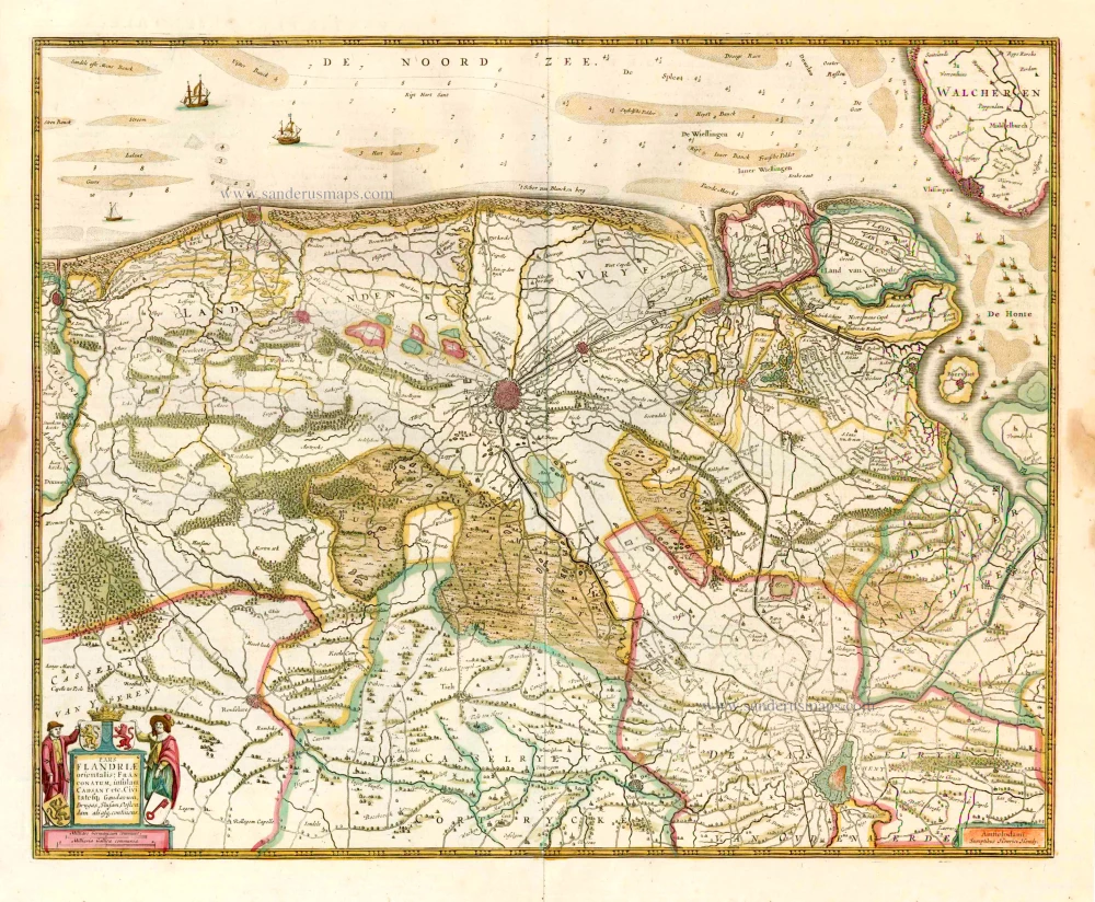
Pars Flandriae Orientalis; Franconatum, insulam Cadsant etc. Civitatesq. Gandavum, Brugas, Slusam, Oostendam aliasq. continens.
Item Number: 26320 Authenticity Guarantee
Category: Antique maps > Europe > Belgium
Old, antique map of West-Vlaanderen (East), by Henricus Hondius.
Oriented to the Northwest
Date of the first edition: 1633
Date of this map: 1641
Copper engraving, printed on paper.
Size (not including margins): 39.5 x 50.5cm (15.4 x 19.7 inches)
Verso text: French
Condition: Original coloured, excellent.
Condition Rating: A+
References: Van der Krogt 1, 1A.1; Schilder 5, p.357-358.
From: Nouveau Theatre du Monde ou Nouvel Atlas comprenant Les Tables et Descriptions de toutes les Regions de la Terre. Amsterdam, H. Hondius, 1641. (Van der Krogt 1, 412)
The Hondius Family
Jodocus Hondius the Elder (1563-1612)
Joost d’Hondt was born at Wakken (Flanders) in 1563. Two years later, his family settled in Ghent, where young Joost displayed an excellent gift for drawing and calligraphy. Through study and lessons, he developed his talents and became an engraver with a good reputation.
Due to the circumstances of the war, he moved to London in 1584, where he settled down as an engraver, instrument-maker, and map-maker. In 1587, he married Coletta van den Keere, sister of the well-known engraver Pieter van den Keere (Petrus Kaerius); some years earlier, his sister, Jacomina, had married Pieter van den Berghe (Petrus Montanus). Joost, who had Latinized his name to Jodocus Hondius, closely co-operated with his two brothers-in-law.
The political situation in the Northern Netherlands in 1593 was such that Jodocus seemed justified in establishing himself in Amsterdam, where many Antwerp printers, publishers, and engravers had gone. In this new centre of cartography, Jodocus Hondius set up his business “In de Wackere Hondt” (in the vigilant dog), this name being an allusion to his birthplace and name. He engraved many maps and published atlases and many other works, such as his continuation of Gerard Mercator’s Atlas.
He suddenly passed away in February 1612. The publishing firm of Jodocus Hondius was continued by his widow, later on, by his two sons, Jodocus Jr. and Henricus, and by his son-in-law, J. Janssonius.
Jodocus Hondius II (1594-1629) & Henricus Hondius (1597-1651)
After the father’s death, the widow and her seven children continued publishing the atlases under the name of Jodocus Hondius till 1620. The firm was reinforced by the very welcome help of Joannes Janssonius (1588-1664), who married 24-year-old Elisabeth Hondius in 1612. After 1619, Mercator’s Atlas was published under the name of Henricus Hondius.
One of the most dramatic events in the early history of commercial cartography in Amsterdam was the sale of Jodocus Hondius Jr.’s copper plates to Willem Jansz. Blaeu in 1629, the year of his death. At least 34 plates, from which Jodocus II had printed single-sheet maps for his benefit, passed into the hands of his great competitor. Immediately after that, his brother, Henricus, and Joannes Janssonius ordered the engraving of identical plates.
Henricus devoted all his energy to publishing the Atlas for an extended period. He saw its growth up to and including the fourth part in 1646; after that, his name no longer figures on the title pages. After 1638, the title of the Atlas was changed to Atlas Novus; Joannes Janssonius mainly carried it on.
The competition with the Blaeu's dates from 1630. In 1630, Willem Janszoon (=Blaeu) first attacked with his Atlantis Appendix. In 1635, Blaeu completed his Theatrum Orbis Terrarum in two volumes with French, Latin, Dutch, and German texts, prompting Henricus Hondius to speed up the enlargement of his Atlas.
Related items
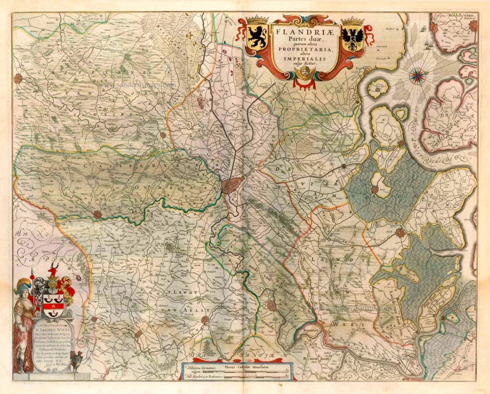
Flandriae Partes duae, quarum altera Proprietata altera Imperialis vulgo dicitur. 1658-59
Oost Vlaanderen by J. Blaeu.
[Item number: 12603]
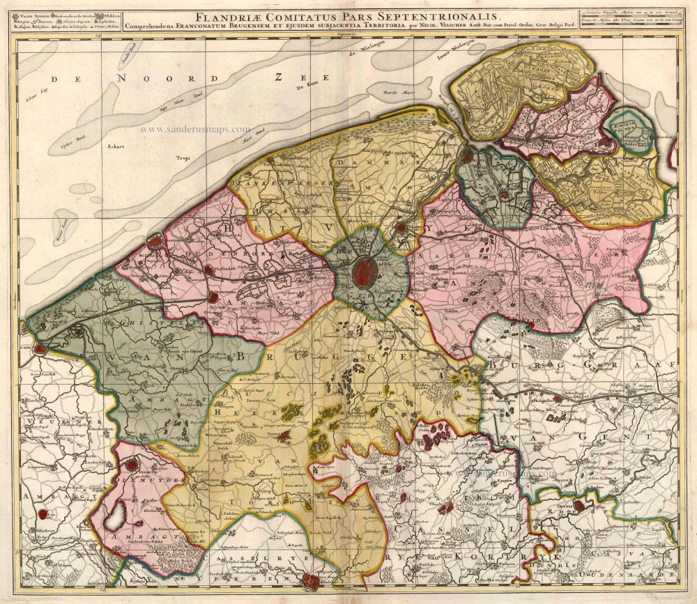
Flandriae Comitatus Pars Septentrionalis, comprehendens Franconatum Brugensem et ejusdem subjacentia Territoria. 1683-1696
Western Flanders (West Vlaanderen) by N. Visscher II.
[Item number: 13092]
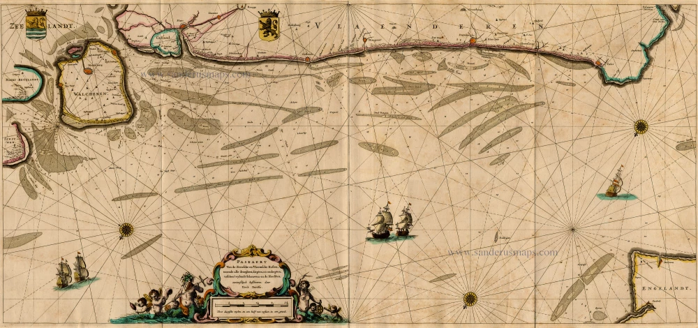
Paskaert van de Zeeusche en Vlaemsche Kusten, tonende Alle Drooghten, Diepten, en Ondiepten, tusschen t'Eylandt Schouwen en de Hoofden, Curieuselyck Beschreven door Dirck Davidsz 1667
Sea chart of Flanders (Vlaanderen) & Zeeland, by Pieter Goos.
[Item number: 19054]
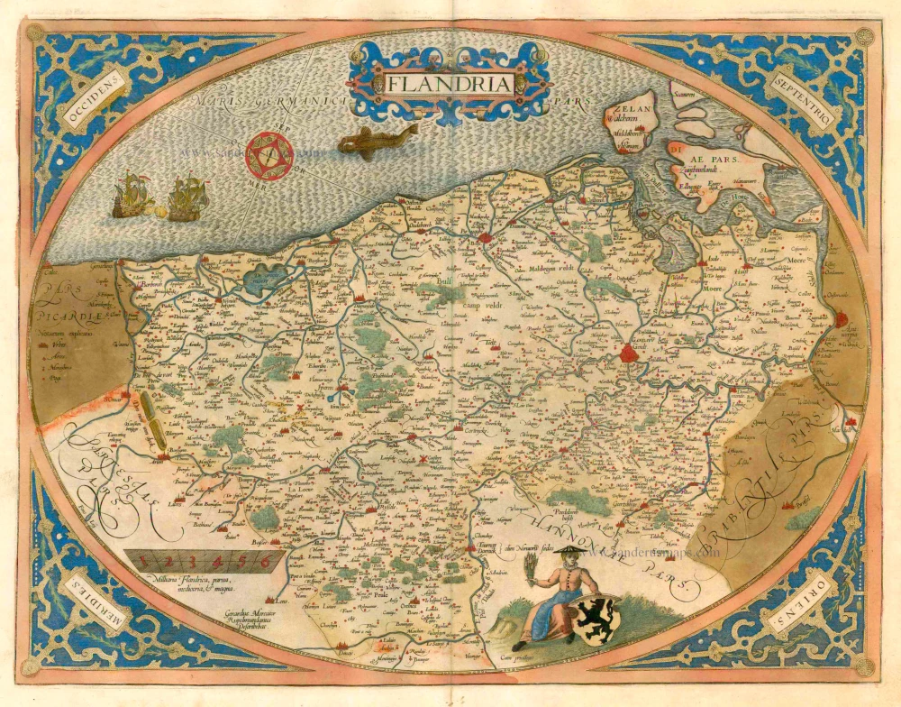
Flandria. 1579
Flanders (Vlaanderen), by Abraham Ortelius.
[Item number: 22228]
Episcopatus Brugensis. 1664-65
Brugge (Bruges), by Joan Blaeu.
[Item number: 26624]
Rare!
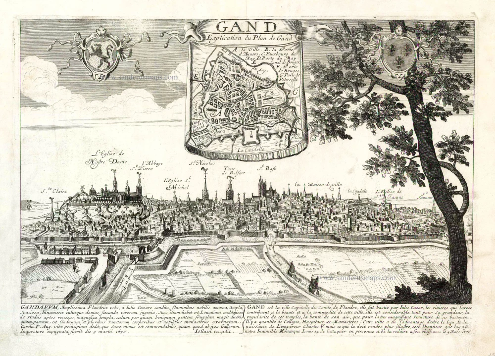
Gand. c. 1678
Ghent (Gent) by Gerard Jollain.
[Item number: 26705]
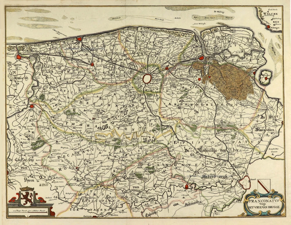
Franconatus Vulgo Het Vrije van Brugge. 1732
Brugse Vrije door Antonius Sanderus.
[Item number: 28224]
Rare.
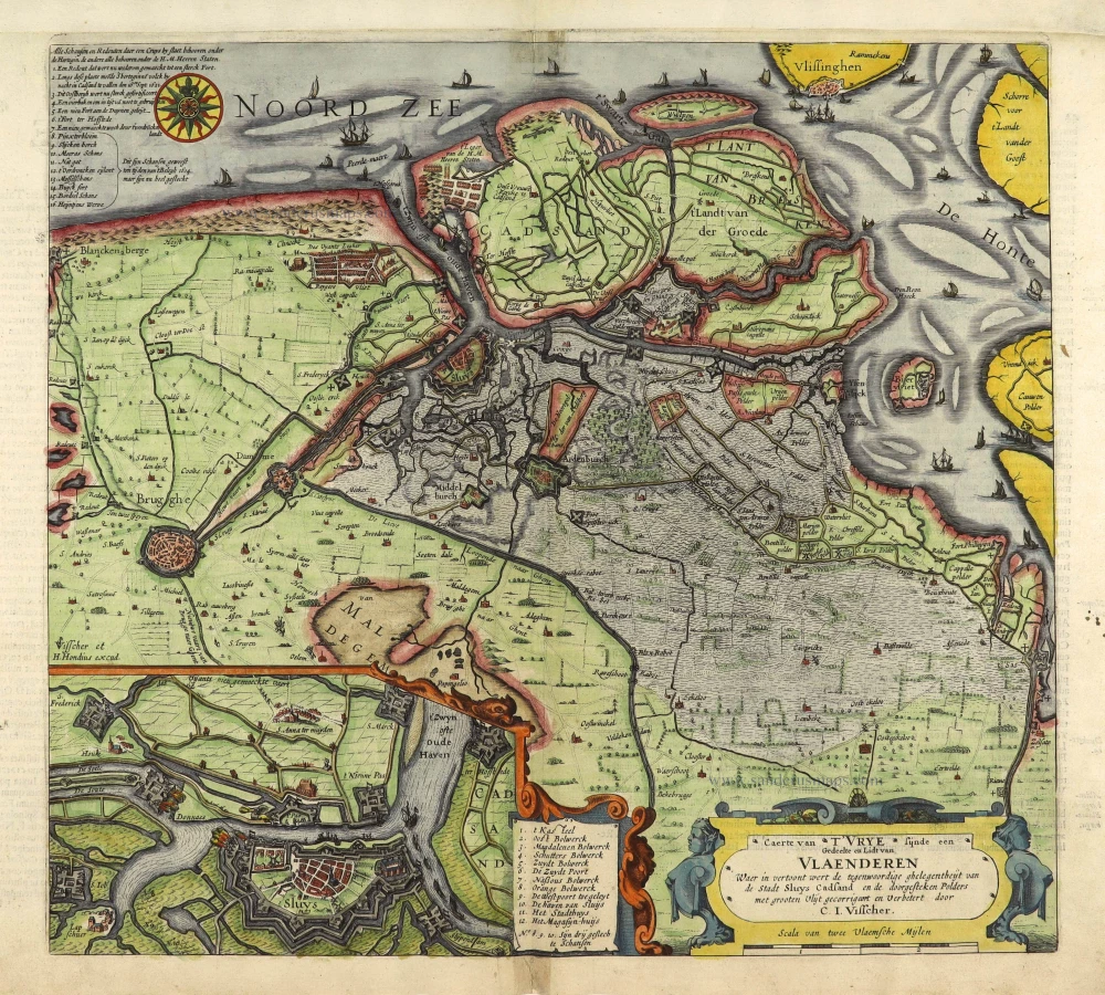
Caerte van T'Vrye sijnde een Gedeelte en Lidt van Vlaenderen. Waer in vertoont wert de tegenwoordige ghelegenheiyt van de Stadt Sluys Cadsand en de doorgesteken Polders 1622
Brugse Vrije by C.J. Visscher, published by Petrus Kaerius (Pieter van den Keere).
[Item number: 28454]
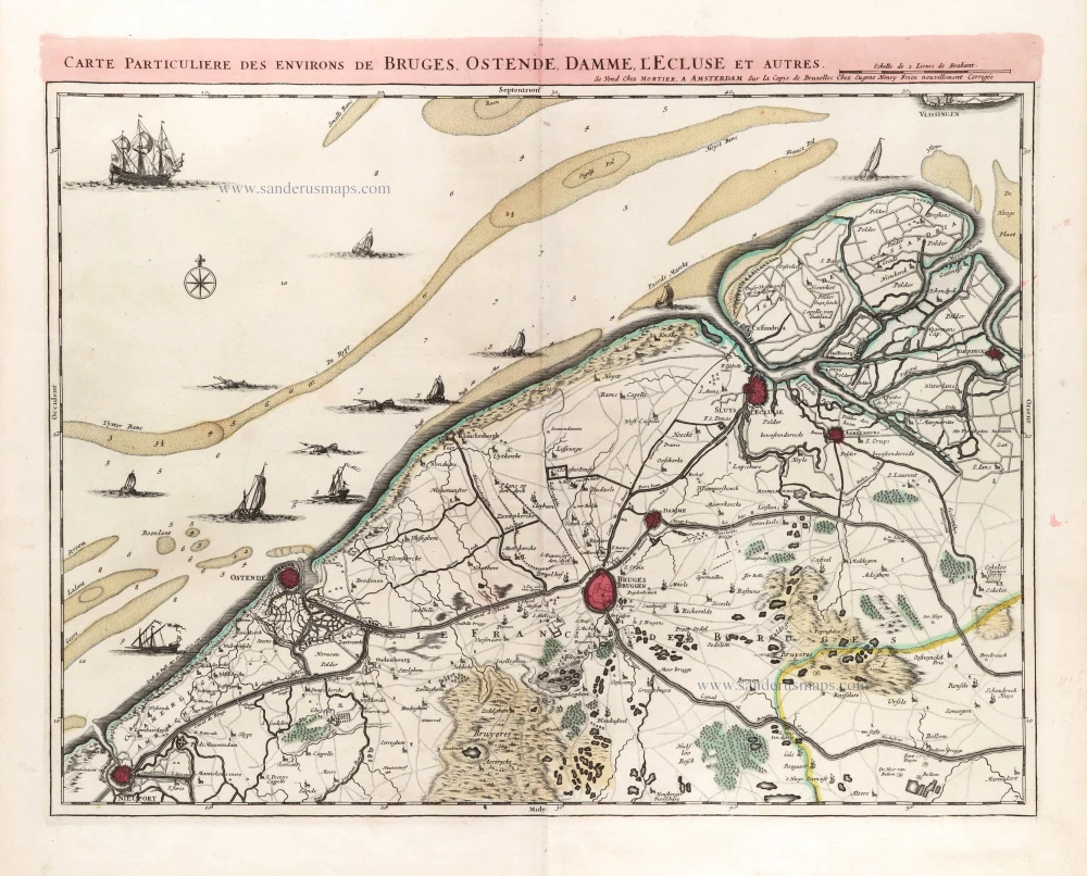
Carte particulière des environs de Bruges, Ostende, Damme, L'Ecluse et Autres. c. 1715
Noord West-Vlaanderen by Eugène Fricx, published by Pierre Mortier.
[Item number: 29594]
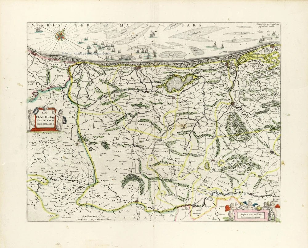
Pars Flandriae Teutonicae Occidentalior. 1643
Western Flanders (West Vlaanderen), by Willem & Joan Blaeu.
[Item number: 29934]