
Pacific Ocean by Abraham Ortelius. 1601
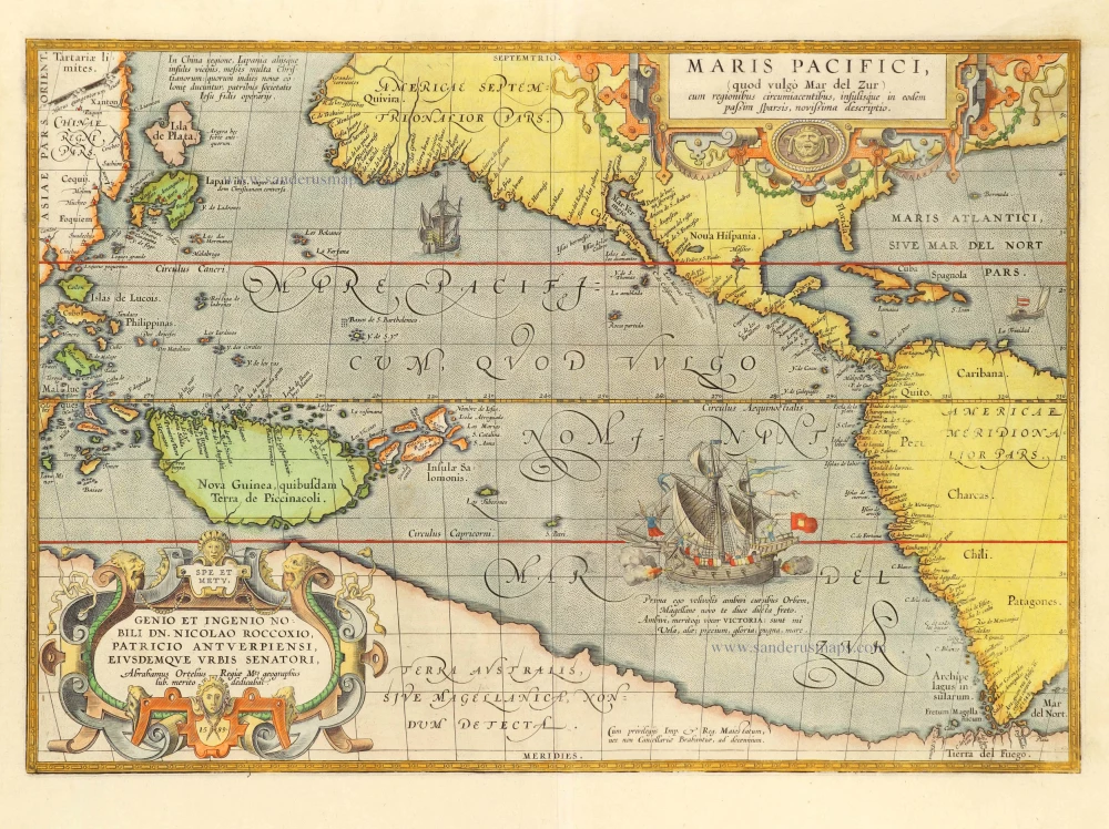
One of the most important maps that appeared in the Ortelius atlases was the first printed map devoted to the Pacific Ocean, the discovery of which is remembered by the depiction, with legend, of Ferdinand Magellan's ship, the Victoria. It was engraved at a time of increasing activity in the Pacific. The English had recently begun raiding the Spanish galleons carrying the gold of Peru up the coast to the Isthmus and those making the arduous journey across from the Philippines to Mexico.
. . . Being one of Ortelius' most desirable maps, combined with the fact that it was not issued in the atlas until 1590, it is not as available as the various versions of his map of America. It was first published in his Additamentum IV in 1590 and was then included in future editions of the Theatrum starting with the Latin of 1591. (Burden)
Abraham Ortelius (1527-1598)
The maker of the 'first atlas', the Theatrum Orbis Terrarum (1570), was born on 4 April 1527 into an old Antwerp family. He learned Latin and studied Greek and mathematics.
Abraham and his sisters Anne and Elizabeth took up map colouring. He was admitted to the Guild of St. Luke as an "illuminator of maps." Besides colouring maps, Ortelius was a dealer in antiques, coins, maps, and books, with the book and map trade gradually becoming his primary occupation.
Business went well because his means permitted him to start an extensive collection of medals, coins, antiques, and a library of many volumes. In addition, he travelled a lot and visited Italy and France, made contacts everywhere with scholars and editors, and maintained extensive correspondence with them.
In 1564 he published his first map, a large and ambitious world wall map. The inspiration for this map may well have been Gastaldi's large world map. In 1565 he published a map of Egypt and a map of the Holy Land, a large map of Asia followed.
In 1568 the production of individual maps for his atlas Theatrum Orbis Terrarum was already in full swing. He completed the atlas in 1569, and in May of 1570, the Theatrum was available for sale. It was one of the most expensive books ever published.
This first edition contained seventy maps on fifty-three sheets. Franciscus Hogenberg engraved the maps.
Later editions included Additamenta (additions), resulting in Ortelius' historical atlas, the Parergon, mostly bound together with the atlas. The Parergon can be called a truly original work of Ortelius, who drew the maps based on his research.
The importance of the Theatrum Orbis Terrarum for geographical knowledge in the last quarter of the sixteenth century is difficult to overemphasize. Nothing was like it until Mercator's atlas appeared twenty-five years later. Demand for the Theatrum was remarkable. Some 24 editions appeared during Ortelius's lifetime and another ten after his death in 1598. Editions were published in Dutch, German, French, Spanish, English, and Italian. The number of map sheets grew from 53 in 1570 to 167 in 1612 in the last edition.
In 1577, engraver Philip Galle and poet-translator Pieter Heyns published the first pocket-sized edition of the Theatrum, the Epitome. The work was trendy. Over thirty editions of this Epitome were published in different languages.
Maris Pacifici, (quod vulgo Mar del Zur) cum regionibus circumiacentibus, insulisque in codem passim sparsis, novissima descriptio.
Item Number: 28744 Authenticity Guarantee
Category: Antique maps > America > The Americas
Old, antique map of the Pacific Ocean, by Abraham Ortelius.
Title: Maris Pacifici, (quod vulgo Mar del Zur) cum regionibus circumiacentibus, insulisque in codem passim sparsis, novissima descriptio.
Cum privilegijs Imp. & Reg. Maiestatum, nec non Cancellariae Brabantiae, ad decennium.
Date of the first edition: 1590.
Date of this map: 1601.
Date on map: 1589.
Copper engraving, printed on paper.
Map size: 345 x 500mm (13.58 x 19.69 inches).
Sheet size: 445 x 525mm (17.52 x 20.67 inches).
Verso: Latin text.
Condition: Original coloured, part of left margin trimmed.
Condition Rating: A.
From: Ortelius A.,Theatrum Orbis Terrarum Abrahami Ortelii Antverp. Geographi Regii. Antwerpen, Plantin Press, 1601. (Van der Krogt 3, 1:052)
One of the most important maps that appeared in the Ortelius atlases was the first printed map devoted to the Pacific Ocean, the discovery of which is remembered by the depiction, with legend, of Ferdinand Magellan's ship, the Victoria. It was engraved at a time of increasing activity in the Pacific. The English had recently begun raiding the Spanish galleons carrying the gold of Peru up the coast to the Isthmus and those making the arduous journey across from the Philippines to Mexico.
. . . Being one of Ortelius' most desirable maps, combined with the fact that it was not issued in the atlas until 1590, it is not as available as the various versions of his map of America. It was first published in his Additamentum IV in 1590 and was then included in future editions of the Theatrum starting with the Latin of 1591. (Burden)
Abraham Ortelius (1527-1598)
The maker of the 'first atlas', the Theatrum Orbis Terrarum (1570), was born on 4 April 1527 into an old Antwerp family. He learned Latin and studied Greek and mathematics.
Abraham and his sisters Anne and Elizabeth took up map colouring. He was admitted to the Guild of St. Luke as an "illuminator of maps." Besides colouring maps, Ortelius was a dealer in antiques, coins, maps, and books, with the book and map trade gradually becoming his primary occupation.
Business went well because his means permitted him to start an extensive collection of medals, coins, antiques, and a library of many volumes. In addition, he travelled a lot and visited Italy and France, made contacts everywhere with scholars and editors, and maintained extensive correspondence with them.
In 1564 he published his first map, a large and ambitious world wall map. The inspiration for this map may well have been Gastaldi's large world map. In 1565 he published a map of Egypt and a map of the Holy Land, a large map of Asia followed.
In 1568 the production of individual maps for his atlas Theatrum Orbis Terrarum was already in full swing. He completed the atlas in 1569, and in May of 1570, the Theatrum was available for sale. It was one of the most expensive books ever published.
This first edition contained seventy maps on fifty-three sheets. Franciscus Hogenberg engraved the maps.
Later editions included Additamenta (additions), resulting in Ortelius' historical atlas, the Parergon, mostly bound together with the atlas. The Parergon can be called a truly original work of Ortelius, who drew the maps based on his research.
The importance of the Theatrum Orbis Terrarum for geographical knowledge in the last quarter of the sixteenth century is difficult to overemphasize. Nothing was like it until Mercator's atlas appeared twenty-five years later. Demand for the Theatrum was remarkable. Some 24 editions appeared during Ortelius's lifetime and another ten after his death in 1598. Editions were published in Dutch, German, French, Spanish, English, and Italian. The number of map sheets grew from 53 in 1570 to 167 in 1612 in the last edition.
In 1577, engraver Philip Galle and poet-translator Pieter Heyns published the first pocket-sized edition of the Theatrum, the Epitome. The work was trendy. Over thirty editions of this Epitome were published in different languages.
Related items
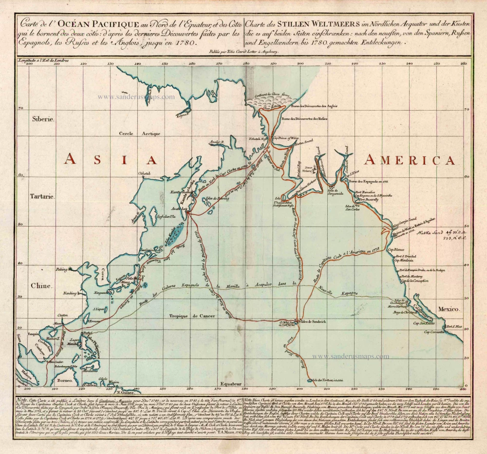
Carte de l'Ocean Pacifique au Nord de l'Equateur, et des Cotes qui le Bornent des Deux Cotes: D'Apres les Dernieres Decouvertes Faites par les Espagnols, les Russes et les Anglois, jusqu'en 1780. 1780
The Northern Pacific Ocean, by T.C. Lotter.
[Item number: 11984]
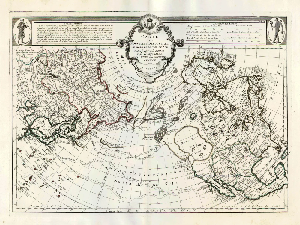
Carte des Nouvelles Decouvertes au Nord de la Mer du Sud, tant à l'Est de la Sibérie et du Kamtchatka, qu'à l'Ouest de la Nouvelle France. 1776-79
Pacific Ocean (North) by Francesco & Paolo Santini
[Item number: 26979]
California as an island
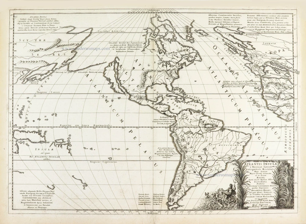
Atlantis Insula. 1692
The Americas by Guillaume Sanson.
[Item number: 28376]
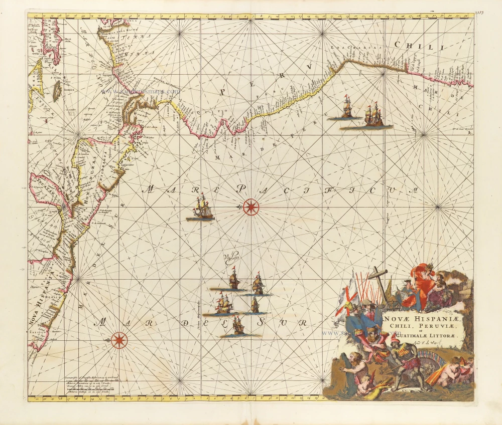
Novae Hispaniae, Chili, Peruviae, et Guatimalae Littorae. ca. 1680
Pacific Coast of America, by Frederick de Wit.
[Item number: 29177]
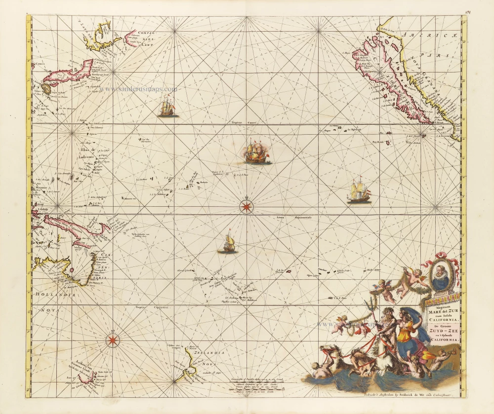
Magnum Mare del Zur cum Insula California = De Groote Zuyd-Zee en 't Eylandt California. c. 1680
Pacific Ocean, by Frederick de Wit.
[Item number: 29241]
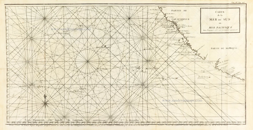
Carte de la Mer du Sud ou Mer Pacifique. Entre l'Equateur et le 39.5 de Latitude septentrion.le. 1748
Map of the southern Pacific, showing a part of the path of George Anson's voyage around the world.
[Item number: 30330]
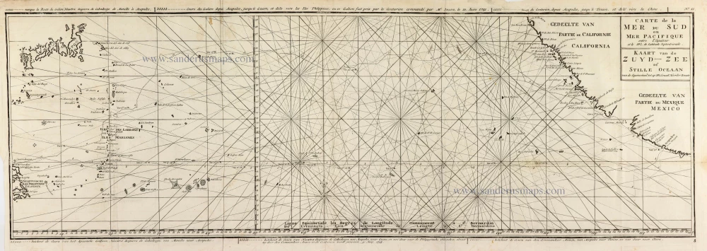
Carte de la Mer du Sud ou Mer Pacifique entre l'Equateur et le 39.5 de Latitude Septentrionale. - Kaart van de Zuyd-Zee of Stille Oceaan ... 1751
Map of the southern Pacific, showing a part of the path of George Anson's voyage around the world.
[Item number: 30609]