
Big and beautiful map.
Africa, by François Halma. Before 1713

This map is an earlier state of Van der Aa's large-format Africa map. Van der Aa added his imprint in a small cartouche under the original title.
François Halma (Langerak, 1653 – Leeuwarden, 1722)
François Halma was a publisher who first established his business at Utrecht in 1674; later moved to Amsterdam where he worked as printer and publisher from 1699-1710 and finally settled at Leeuwarden, where he died in 1722.
Apart from many theological and historical works, he published a small number of geographical works and atlases. In 1695, during his period at Utrecht, he published Ptolemy’s Tabulae Geographicae orbis terrarium. His finest work appeared at Leeuwarden in 1718: the re-issue of Schotanus à Sterringa’s Friesche Atlas of 1698. He also published an edition of Sanson’s Description de l’Univers.
L'Afrique Selon les Nouvelles Observations de Messrs. de l'Academie des Sciences, etc.
Item Number: 27853 Authenticity Guarantee
Category: Antique maps > Africa
Old, antique map of Africa, by François Halma.
Title: L'Afrique Selon les Nouvelles Observations de Messrs. de l'Academie des Sciences, etc.
[Above map:] Africa in Praecipuas ipsius Partes Distributa, ad Observationes Academiae Regiae Scientiarum, et Exquisitissimas Tabulas, quae nunquam Antehac Lucem Viderunt, Excusa A Francisco Halma, Cum privilegio Ordinum Hollandiae et Westfrisiae.
Date of the first edition: Before 1713.
Date of this map: Before 1713.
Copper engraving, printed on paper.
Size (not including margins): 500 x 660mm (19.69 x 25.98 inches).
Verso: Blank text.
Condition: Original coloured, small reinforcement at lower centrefold.
Condition Rating: A.
References: van der Krogt A, See 60:03
Separate publication.
This map is an earlier state of Van der Aa's large-format Africa map. Van der Aa added his imprint in a small cartouche under the original title.
François Halma (Langerak, 1653 – Leeuwarden, 1722)
François Halma was a publisher who first established his business at Utrecht in 1674; later moved to Amsterdam where he worked as printer and publisher from 1699-1710 and finally settled at Leeuwarden, where he died in 1722.
Apart from many theological and historical works, he published a small number of geographical works and atlases. In 1695, during his period at Utrecht, he published Ptolemy’s Tabulae Geographicae orbis terrarium. His finest work appeared at Leeuwarden in 1718: the re-issue of Schotanus à Sterringa’s Friesche Atlas of 1698. He also published an edition of Sanson’s Description de l’Univers.
Related items

Africa Ex magna orbis terre 1633
Africa, by G. Mercator.
[Item number: 1452]

Scarce
Africae Tabula Nova. 1575
Africa, by François de Belleforest.
[Item number: 27380]
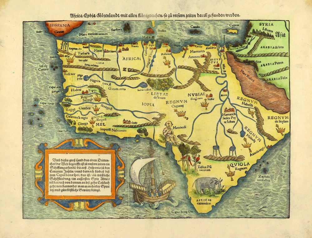
Africa / Lybia / Morenland / mit allen Künigreichen / so zu unsern zeiten darin gefunden werden. 1572
Africa by Sebastian Münster.
[Item number: 28142]

Africae Accurata Tabula. 1656-77
Africa by Nicolaes Visscher I.
[Item number: 28551]

Africa Ex magna orbis terre. 1623
Africa by Gerard Mercator.
[Item number: 28678]

Totius Africae Accuratissima Tabula, c. 1697-1704
Africa, by Frederick De Wit.
[Item number: 29289]

Important map
Presbiteri Iohannis, sive, Abissinorum Imperii Descriptio. 1584
Prestor John Map (Western & Central Africa), by Abraham Ortelius.
[Item number: 29722]
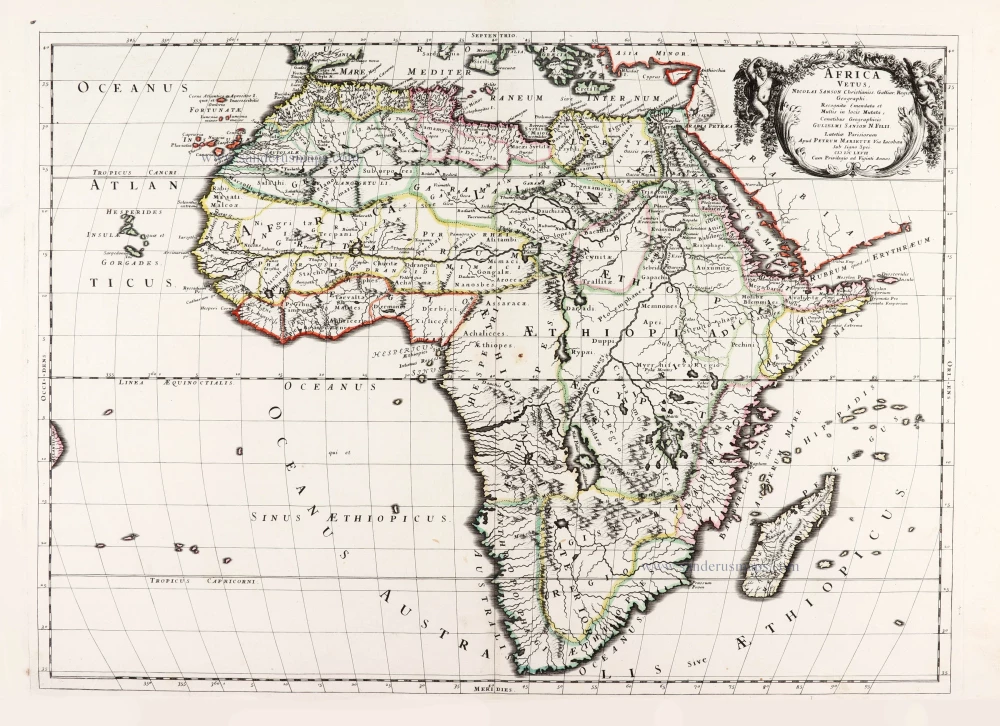
Africa Vetus. 1667-69
Ancient Africa by Nicolas & Guillaume Sanson.
[Item number: 30003]

La table & description universelle de toute l' Afrique, voire estendue outre les limites de Ptol. 1568
AFRICA by Sebastian Münster
[Item number: 30519]

Africa 1621
Africa by Giovanni Magini.
[Item number: 30775]

L'Afrique divisée suivant l'estendue de ses principales parties ou sont distingués les uns des autres, Les Empires, Monarchies, Royaumes, Estats et Peuples qui partagent aujourd'huy l'Afrique sur les Relations les plus Nouvelles. 1692
Africa, by N. Sanson, so-called published by Hubert Jaillot. (Pirated edition by Pierre Mortier).
[Item number: 31141]

Africae nova descriptio. 1640
Africa by Willem Blaeu.
[Item number: 31334]

Totius Africae Accuratissima Tabula Authore I. Danckerts Amstelodami 1683-1690
Africa by Justus Danckerts.
[Item number: 31787]

Africa. 1618
Africa by Petrus Bertius, published by Jodocus Hondius II.
[Item number: 32060]

Totius Africae Nova Repraesentatio qua Practer Diversos in ea Status et Regiones, etiam Origo Nili c. 1720
Africa by Homann J.B.
[Item number: 32097]

Novissima et Perfectissima Africae 1696-1713
Africa by Danckerts J.
[Item number: 32459]
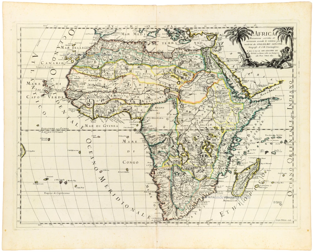
L' Africa. 1677
Africa by Giovanni De Rossi, after Nicolas Sanson.
[Item number: 32888]

L'Afrique divisée en ses principaux Etats. 1762
Africa by Jean Denis Janvier, published by Jean Lattré.
[Item number: 33071]