
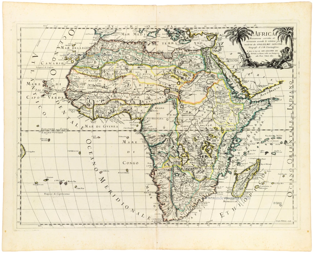
Africa by Justus Danckerts. 1683-1690

The Danckerts Family.
The Danckerts family of Amsterdam was one of the best-known print and map sellers in 17th century Amsterdam. Their business activity covered a vast period, from ca. 1633. From 1669 until 1701, father Justus and his sons had their shop in the ‘Calverstraet in de Danckbaerheyt’.
Cornelis Danckerts (1561-1631) was a printseller born in Amsterdam and active in Antwerp.
Cornelis Danckerts, the elder (1603-1656) was an engraver and publisher in Amsterdam and Nieuwendijk. Son of Cornelis (above), whom he succeeded in 1631.
The house of Danckerts gained its greatest fame from Justus Danckerts (1635-1701 - son of Cornelis the elder) and his two sons, Theodorus and Cornelis. Dancker Danckerts (1634-1666), the elder brother of Justus, was known for his etchings of paintings, maps, and publications.
The grandfather, father, and sons were highly skilled and excellent artistic drafters and engravers. They are famous for the edition of their Atlas, which appeared from ca. 1686, and for several monumental and beautiful wall maps and views. However, compared with that published by the Blaeu's or Janssonius's, their cartographic work has attracted little attention and has never received proper recognition.
On 14 August 1684, Justus and his sons obtained the privilege from the States of Holland for their publications. In 1713, twelve years after Justus Danckerts, the heirs decided to sell part of the stock of maps and atlases and many copperplates. In 1727, after the death of the last surviving brother Theodorus, a final sale took place.
Totius Africae Accuratissima Tabula Authore I. Danckerts Amstelodami
Item Number: 31787 Authenticity Guarantee
Category: Antique maps > Africa
Africa by Justus Danckerts.
Title: Totius Africae Accuratissima Tabula Authore I. Danckerts Amstelodami
Date of the first edition: 1683.
Date of this map: 1683-1690.
Copper engraving, printed on paper.
Image size: 495 x 580mm (19½ x 22¾ inches).
Sheet size: 510 x 600mm (20 x 23½ inches).
Verso: Blank.
Condition: Hand coloured, excellent.
Condition Rating: A+.
Separate publication - appeared in Danckerts atlases from 1688-1689.
The Danckerts Family.
The Danckerts family of Amsterdam was one of the best-known print and map sellers in 17th century Amsterdam. Their business activity covered a vast period, from ca. 1633. From 1669 until 1701, father Justus and his sons had their shop in the ‘Calverstraet in de Danckbaerheyt’.
Cornelis Danckerts (1561-1631) was a printseller born in Amsterdam and active in Antwerp.
Cornelis Danckerts, the elder (1603-1656) was an engraver and publisher in Amsterdam and Nieuwendijk. Son of Cornelis (above), whom he succeeded in 1631.
The house of Danckerts gained its greatest fame from Justus Danckerts (1635-1701 - son of Cornelis the elder) and his two sons, Theodorus and Cornelis. Dancker Danckerts (1634-1666), the elder brother of Justus, was known for his etchings of paintings, maps, and publications.
The grandfather, father, and sons were highly skilled and excellent artistic drafters and engravers. They are famous for the edition of their Atlas, which appeared from ca. 1686, and for several monumental and beautiful wall maps and views. However, compared with that published by the Blaeu's or Janssonius's, their cartographic work has attracted little attention and has never received proper recognition.
On 14 August 1684, Justus and his sons obtained the privilege from the States of Holland for their publications. In 1713, twelve years after Justus Danckerts, the heirs decided to sell part of the stock of maps and atlases and many copperplates. In 1727, after the death of the last surviving brother Theodorus, a final sale took place.
Related items

Africa Ex magna orbis terre 1633
Africa, by G. Mercator.
[Item number: 1452]

Africae Antiquae, et quarundam Europae, Asiaeque Adiacentium Regionum, 1684
Africa, by Janssonius à Waesberghe.
[Item number: 10916]

Africa Tertia Pars Terrae. 1581
Africa, by H. Bünting.
[Item number: 26228]

Scarce
Africae Tabula Nova. 1575
Africa, by François de Belleforest.
[Item number: 27380]

Affricae Tabula Nova. 1598
Africa, by Sebastian Münster.
[Item number: 27416]

Big and beautiful map.
L'Afrique Selon les Nouvelles Observations de Messrs. de l'Academie des Sciences, etc. Before 1713
Africa, by François Halma.
[Item number: 27853]
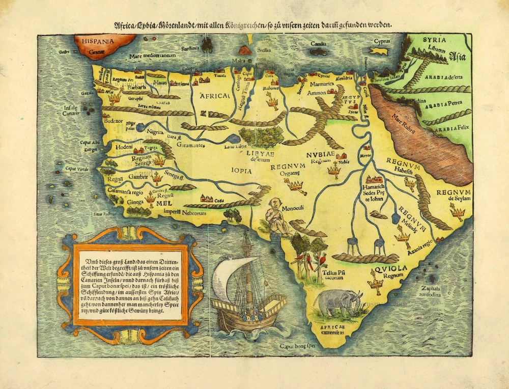
Africa / Lybia / Morenland / mit allen Künigreichen / so zu unsern zeiten darin gefunden werden. 1572
Africa by Sebastian Münster.
[Item number: 28142]

Africae Accurata Tabula. 1656-77
Africa by Nicolaes Visscher I.
[Item number: 28551]

Africa Ex magna orbis terre. 1623
Africa by Gerard Mercator.
[Item number: 28678]

Africae Antiquae, et quarundam Europae, Asiaeque Adiacentium Regionum, 1684
Africa, by Janssonius à Waesberghe.
[Item number: 29053]

Totius Africae Accuratissima Tabula, c. 1697-1704
Africa, by Frederick De Wit.
[Item number: 29289]

Afrique. 1650
Africa by Nicolas Sanson.
[Item number: 29602]

La table & description universelle de toute l' Afrique, voire estendue outre les limites de Ptol. 1568
AFRICA by Sebastian Münster
[Item number: 30519]

Africa 1621
Africa by Giovanni Magini.
[Item number: 30775]

Carte de l'Afrique Corrigee et Augmentee, dessus Toutes les Aultres cy devant Faictes par P. Bertius. c. 1630-1650
Africa by Petrus Bertius, published by Melchior Tavernier.
[Item number: 30858]

Important map
Africae Tabula Nova. 1575
Africa by Abraham Ortelius
[Item number: 30948]

L'Afrique divisée suivant l'estendue de ses principales parties ou sont distingués les uns des autres, Les Empires, Monarchies, Royaumes, Estats et Peuples qui partagent aujourd'huy l'Afrique sur les Relations les plus Nouvelles. 1692
Africa, by N. Sanson, so-called published by Hubert Jaillot. (Pirated edition by Pierre Mortier).
[Item number: 31141]

Beautiful
Tabula Quarta Africae 1513
Ptolemy map of Africa by Martin Waldseemüller
[Item number: 31187]

Africae nova descriptio. 1640
Africa by Willem Blaeu.
[Item number: 31334]

Africa. 1618
Africa by Petrus Bertius, published by Jodocus Hondius II.
[Item number: 32060]

Totius Africae Nova Repraesentatio qua Practer Diversos in ea Status et Regiones, etiam Origo Nili c. 1720
Africa by Homann J.B.
[Item number: 32097]

Novissima et Perfectissima Africae 1696-1713
Africa by Danckerts J.
[Item number: 32459]
L' Africa. 1677
Africa by Giovanni De Rossi, after Nicolas Sanson.
[Item number: 32888]

L'Afrique divisée en ses principaux Etats. 1762
Africa by Jean Denis Janvier, published by Jean Lattré.
[Item number: 33071]