
Africa by Nicolaes Visscher I. 1656-77


The Visscher Family
For nearly a century, the members of the Visscher family were essential art dealers and map publishers in Amsterdam.
Claes Jansz. Visscher, or N.J. Piscator (1587-1652)
Claes Jansz. Vischer bought a house in Amsterdam, 'de gulden Bors', on the crucial Kalverstraat and changed the name into "In de Visscher"; under this title, the shop was to flourish for many years.
He was famous for his engravings and etchings of Dutch landscapes and 'historical scenes', such as sieges, battles, etc. These 'historical scenes' were considered contemporary illustrated news items, especially e.g. that of 'the Eighty Years' War'.
For the publication of his first atlas, he bought copperplates of the atlas Germania Inferior by Pieter van den Keere (1623).
In 1649, he published an atlas entitled Tabularum Geographicarum Contractarum, containing the same maps as Langenes' Caert Thresoor, for which Visscher had only new title pages engraved.
Claes Jansz. Visscher died in 1652. His wife, Neeltjen Florisdr., had already died in 1640. They had seven children, four of whom were still alive at Claes Jansz.'s death. One was Nicolaes Visscher I, who was to continue his father's business.
Nicolaes Visscher I (1618-1679)
Nicolaes Visscher I partnered with his father, continued the business, and stayed on the Kalverstraat 'in de Visscher' till his death.
In about 1657, the first edition of his Atlas Contractus Orbis Terrarum appeared.
Between 1664 and 1677, several editions of his Atlas Contractus appeared without a printed index, for these atlases had no fixed contents but were composed according to the buyer's financial leaping pole.
In May 1664, Nicolaes Visscher was admitted as a member of the Booksellers' Guild of his town. In July 1677, he was granted a patent of the States of Holland and West-Friesland for printing and publishing maps and atlases for 15 years.
After this, he again published an Atlas Contractus with a printed index. At about the same time, he also brought out an Atlas Minor.
Nicolaes Visscher II (1649-1702)
Nicolaes Visscher II inherited the 'shop' from his father. To obtain a new privilege, he applied to the States of Holland and West-Friesland in 1682 for a patent for printing and publishing maps. This patent was granted to him the same year. He moved the firm to the Dam, but it kept the same signboard: "In de Visscher".
Around 1683, he published his first Atlas Minor with a printed index of 91 maps. In 1684, an atlas Germania Inferior appeared. Till 1697, he published another number of atlases. He used his grandfather's (Claes Jansz.) maps less often now and relied more and more on his own.
The wars waged at this time initiated the compilation of maps of the countries where the armies operated. Many war maps were included in the various editions of his Atlas Minor.
After Nicolaes's death, his wife, Elizabeth Verseyl, published all the war maps as an atlas under the title De Stoel des Oorlogs in de Wereld (The seat of war in the world).
The widow of Nicolaes Visscher II (?-1726)
His widow continued the business energetically, and by her hand, under the name of her deceased husband, numerous atlases appeared, e.g., several editions of the Atlas Minor, an Atlas Maior and De Stoel des Oorlogs. The shop enjoyed a high reputation due to the assortment's incredible variety. Not only 'Visscher' maps but also maps of other publishers were obtainable. With the death of Elizabeth Verseyl in 1726, the last descendant died of a great map- and atlas-publishing firm in Amsterdam.
Africae Accurata Tabula.
Item Number: 28551 Authenticity Guarantee
Category: Antique maps > Africa
Old, antique map of Africa, by Nicolaes Visscher I.
Title: Africae Accurata Tabula.
ex officina Nic. Visscher.
With dedication to Gerard Schaep by Nicolaes Visscher.
Rare first state.
Date of the first edition: 1656.
Date of this map: 1656-77.
Copper engraving, printed on paper.
Map size: 436 x 545mm (17.17 x 21.46 inches).
Sheet size: 540 x 615mm (21.26 x 24.21 inches).
Verso: Blank.
Condition: Original coloured, some light offsetting.
Condition Rating: A+.
References: Betz, #87.1; Norwich, #55
From: Atlas Contractus Orbis Terrarum Praecipuas ac Novissimas Complectens Tabulas. Amsterdam, N. Visscher, 1656-77. (Koeman III, Vis5-8)
The Visscher Family
For nearly a century, the members of the Visscher family were essential art dealers and map publishers in Amsterdam.
Claes Jansz. Visscher, or N.J. Piscator (1587-1652)
Claes Jansz. Vischer bought a house in Amsterdam, 'de gulden Bors', on the crucial Kalverstraat and changed the name into "In de Visscher"; under this title, the shop was to flourish for many years.
He was famous for his engravings and etchings of Dutch landscapes and 'historical scenes', such as sieges, battles, etc. These 'historical scenes' were considered contemporary illustrated news items, especially e.g. that of 'the Eighty Years' War'.
For the publication of his first atlas, he bought copperplates of the atlas Germania Inferior by Pieter van den Keere (1623).
In 1649, he published an atlas entitled Tabularum Geographicarum Contractarum, containing the same maps as Langenes' Caert Thresoor, for which Visscher had only new title pages engraved.
Claes Jansz. Visscher died in 1652. His wife, Neeltjen Florisdr., had already died in 1640. They had seven children, four of whom were still alive at Claes Jansz.'s death. One was Nicolaes Visscher I, who was to continue his father's business.
Nicolaes Visscher I (1618-1679)
Nicolaes Visscher I partnered with his father, continued the business, and stayed on the Kalverstraat 'in de Visscher' till his death.
In about 1657, the first edition of his Atlas Contractus Orbis Terrarum appeared.
Between 1664 and 1677, several editions of his Atlas Contractus appeared without a printed index, for these atlases had no fixed contents but were composed according to the buyer's financial leaping pole.
In May 1664, Nicolaes Visscher was admitted as a member of the Booksellers' Guild of his town. In July 1677, he was granted a patent of the States of Holland and West-Friesland for printing and publishing maps and atlases for 15 years.
After this, he again published an Atlas Contractus with a printed index. At about the same time, he also brought out an Atlas Minor.
Nicolaes Visscher II (1649-1702)
Nicolaes Visscher II inherited the 'shop' from his father. To obtain a new privilege, he applied to the States of Holland and West-Friesland in 1682 for a patent for printing and publishing maps. This patent was granted to him the same year. He moved the firm to the Dam, but it kept the same signboard: "In de Visscher".
Around 1683, he published his first Atlas Minor with a printed index of 91 maps. In 1684, an atlas Germania Inferior appeared. Till 1697, he published another number of atlases. He used his grandfather's (Claes Jansz.) maps less often now and relied more and more on his own.
The wars waged at this time initiated the compilation of maps of the countries where the armies operated. Many war maps were included in the various editions of his Atlas Minor.
After Nicolaes's death, his wife, Elizabeth Verseyl, published all the war maps as an atlas under the title De Stoel des Oorlogs in de Wereld (The seat of war in the world).
The widow of Nicolaes Visscher II (?-1726)
His widow continued the business energetically, and by her hand, under the name of her deceased husband, numerous atlases appeared, e.g., several editions of the Atlas Minor, an Atlas Maior and De Stoel des Oorlogs. The shop enjoyed a high reputation due to the assortment's incredible variety. Not only 'Visscher' maps but also maps of other publishers were obtainable. With the death of Elizabeth Verseyl in 1726, the last descendant died of a great map- and atlas-publishing firm in Amsterdam.
Related items

Africa Ex magna orbis terre 1633
Africa, by G. Mercator.
[Item number: 1452]

Scarce
Africae Tabula Nova. 1575
Africa, by François de Belleforest.
[Item number: 27380]

Affricae Tabula Nova. 1598
Africa, by Sebastian Münster.
[Item number: 27416]

Big and beautiful map.
L'Afrique Selon les Nouvelles Observations de Messrs. de l'Academie des Sciences, etc. Before 1713
Africa, by François Halma.
[Item number: 27853]
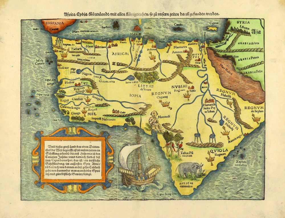
Africa / Lybia / Morenland / mit allen Künigreichen / so zu unsern zeiten darin gefunden werden. 1572
Africa by Sebastian Münster.
[Item number: 28142]

Totius Africae Accuratissima Tabula, c. 1697-1704
Africa, by Frederick De Wit.
[Item number: 29289]

Important map
Presbiteri Iohannis, sive, Abissinorum Imperii Descriptio. 1584
Prestor John Map (Western & Central Africa), by Abraham Ortelius.
[Item number: 29722]
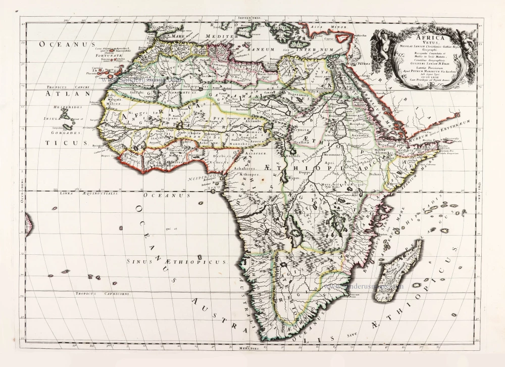
Africa Vetus. 1667-69
Ancient Africa by Nicolas & Guillaume Sanson.
[Item number: 30003]

La table & description universelle de toute l' Afrique, voire estendue outre les limites de Ptol. 1568
AFRICA by Sebastian Münster
[Item number: 30519]

Africa 1621
Africa by Giovanni Magini.
[Item number: 30775]

Important map
Africae Tabula Nova. 1575
Africa by Abraham Ortelius
[Item number: 30948]

L'Afrique divisée suivant l'estendue de ses principales parties ou sont distingués les uns des autres, Les Empires, Monarchies, Royaumes, Estats et Peuples qui partagent aujourd'huy l'Afrique sur les Relations les plus Nouvelles. 1692
Africa, by N. Sanson, so-called published by Hubert Jaillot. (Pirated edition by Pierre Mortier).
[Item number: 31141]

Africae nova descriptio. 1640
Africa by Willem Blaeu.
[Item number: 31334]

Totius Africae Accuratissima Tabula Authore I. Danckerts Amstelodami 1683-1690
Africa by Justus Danckerts.
[Item number: 31787]

Africa. 1618
Africa by Petrus Bertius, published by Jodocus Hondius II.
[Item number: 32060]

Totius Africae Nova Repraesentatio qua Practer Diversos in ea Status et Regiones, etiam Origo Nili c. 1720
Africa by Homann J.B.
[Item number: 32097]

Novissima et Perfectissima Africae 1696-1713
Africa by Danckerts J.
[Item number: 32459]
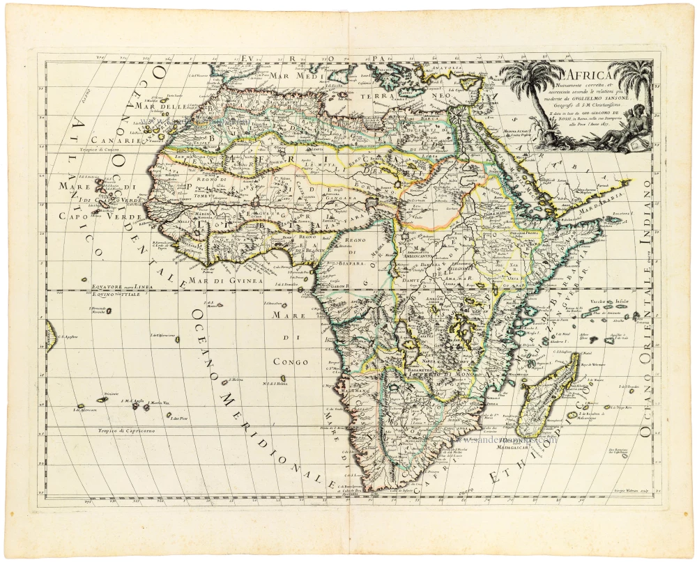
L' Africa. 1677
Africa by Giovanni De Rossi, after Nicolas Sanson.
[Item number: 32888]

L'Afrique divisée en ses principaux Etats. 1762
Africa by Jean Denis Janvier, published by Jean Lattré.
[Item number: 33071]