
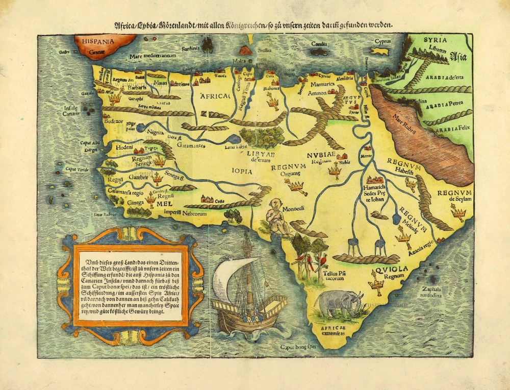
Africa, by Sebastian Münster. 1598

Claudius Ptolemy (c.100 – c.170 AD)
Sebastian Münster (1488-1552)
Sebastian Münster, a German geographer, cartographer, Hebraist, and theologian, was born in Ingelheim, near Mainz In 1505, he went to Heidelberg to enter the Franciscan order. In 1507 he went to Louvain, where he studied mathematics, geography, and astronomy. In 1509 Münster became a student of Konrad Pelikan, who taught Hebrew and Greek as well as mathematics and cosmography. In 1518 he completed his studies at the University of Tübingen. He was the favorite of the famous mathematician and astronomer Johann Stöffler.
In 1524 Münster was appointed professor of Hebrew at Heidelberg University. In 1525 he published his first map as part of a broadside: The Instrument of the Suns combined a map, calendar, astrological almanac, sundial, and nocturnal on one attractive sheet, suitable for wall mounting.
In 1540 he published a Latin edition of Ptolemy's Geographia with illustrations. He based this edition on the Latin translation by Willibald Pirkheimer and produced new maps to supplement the Ptolemaic maps. The twenty-seven maps of the Ptolemaic canon are supplemented by twenty-one new maps. Further editions appeared in 1541 and 1542.
In 1544 he published the Cosmographia, a bulky book with 659 pages and some 520 woodcuts. Maps in this edition included three maps from the Ptolemaic canon and fourteen modern maps (from previous editions of the Geographia), as well as nine new maps. Later editions (1545, 1546, 1548) enlarged the Cosmographia. The 1550 edition contains cities, portraits, and costumes. These editions in both Latin and German constitute the full fruition of Münster's dream of a comprehensive geography.
The Cosmographia was one of the most successful works of the 16th century. It passed through 24 editions in 100 years, in different languages, including Latin, French, Italian, English, and even Czech. The last German edition was published in 1628.
He died at Basel of the plague in 1552.
As a cartographer, Münster deserves special recognition for formulating a plan for a comprehensive and uniform map of a country. As a geographer, his greatest achievement was the Cosmographia. (Karrow).
Affricae Tabula Nova.
Item Number: 27416 Authenticity Guarantee
Category: Antique maps > Africa
Old, antique map of Africa, by Sebastian Münster.
Title: Affricae Tabula Nova.
Date of the first edition: 1588.
Date of this map: 1598.
Woodcut, printed on paper.
Size (not including margins): 310 x 360mm (12.2 x 14.17 inches).
Verso: German text.
Condition: Waterstain.
Condition Rating: A.
From: Cosmographen: das ist Beschreibung Aller Länder, Herschaffen und fürnemesten Stetten des gantzen Erdbodems ... Basle, S. Petri, 1598.
Claudius Ptolemy (c.100 – c.170 AD)
Sebastian Münster (1488-1552)
Sebastian Münster, a German geographer, cartographer, Hebraist, and theologian, was born in Ingelheim, near Mainz In 1505, he went to Heidelberg to enter the Franciscan order. In 1507 he went to Louvain, where he studied mathematics, geography, and astronomy. In 1509 Münster became a student of Konrad Pelikan, who taught Hebrew and Greek as well as mathematics and cosmography. In 1518 he completed his studies at the University of Tübingen. He was the favorite of the famous mathematician and astronomer Johann Stöffler.
In 1524 Münster was appointed professor of Hebrew at Heidelberg University. In 1525 he published his first map as part of a broadside: The Instrument of the Suns combined a map, calendar, astrological almanac, sundial, and nocturnal on one attractive sheet, suitable for wall mounting.
In 1540 he published a Latin edition of Ptolemy's Geographia with illustrations. He based this edition on the Latin translation by Willibald Pirkheimer and produced new maps to supplement the Ptolemaic maps. The twenty-seven maps of the Ptolemaic canon are supplemented by twenty-one new maps. Further editions appeared in 1541 and 1542.
In 1544 he published the Cosmographia, a bulky book with 659 pages and some 520 woodcuts. Maps in this edition included three maps from the Ptolemaic canon and fourteen modern maps (from previous editions of the Geographia), as well as nine new maps. Later editions (1545, 1546, 1548) enlarged the Cosmographia. The 1550 edition contains cities, portraits, and costumes. These editions in both Latin and German constitute the full fruition of Münster's dream of a comprehensive geography.
The Cosmographia was one of the most successful works of the 16th century. It passed through 24 editions in 100 years, in different languages, including Latin, French, Italian, English, and even Czech. The last German edition was published in 1628.
He died at Basel of the plague in 1552.
As a cartographer, Münster deserves special recognition for formulating a plan for a comprehensive and uniform map of a country. As a geographer, his greatest achievement was the Cosmographia. (Karrow).
Related items

Africa Ex magna orbis terre 1633
Africa, by G. Mercator.
[Item number: 1452]

Africa Tertia Pars Terrae. 1581
Africa, by H. Bünting.
[Item number: 26228]
Africa / Lybia / Morenland / mit allen Künigreichen / so zu unsern zeiten darin gefunden werden. 1572
Africa by Sebastian Münster.
[Item number: 28142]

Africae Accurata Tabula. 1656-77
Africa by Nicolaes Visscher I.
[Item number: 28551]

Africa Ex magna orbis terre. 1623
Africa by Gerard Mercator.
[Item number: 28678]

Totius Africae Accuratissima Tabula, c. 1697-1704
Africa, by Frederick De Wit.
[Item number: 29289]

Important map
Presbiteri Iohannis, sive, Abissinorum Imperii Descriptio. 1584
Prestor John Map (Western & Central Africa), by Abraham Ortelius.
[Item number: 29722]
Africa Vetus. 1667-69
Ancient Africa by Nicolas & Guillaume Sanson.
[Item number: 30003]

La table & description universelle de toute l' Afrique, voire estendue outre les limites de Ptol. 1568
AFRICA by Sebastian Münster
[Item number: 30519]

Africa 1621
Africa by Giovanni Magini.
[Item number: 30775]

Important map
Africae Tabula Nova. 1575
Africa by Abraham Ortelius
[Item number: 30948]

L'Afrique divisée suivant l'estendue de ses principales parties ou sont distingués les uns des autres, Les Empires, Monarchies, Royaumes, Estats et Peuples qui partagent aujourd'huy l'Afrique sur les Relations les plus Nouvelles. 1692
Africa, by N. Sanson, so-called published by Hubert Jaillot. (Pirated edition by Pierre Mortier).
[Item number: 31141]

Africae nova descriptio. 1640
Africa by Willem Blaeu.
[Item number: 31334]

Totius Africae Accuratissima Tabula Authore I. Danckerts Amstelodami 1683-1690
Africa by Justus Danckerts.
[Item number: 31787]

Africa. 1618
Africa by Petrus Bertius, published by Jodocus Hondius II.
[Item number: 32060]

Totius Africae Nova Repraesentatio qua Practer Diversos in ea Status et Regiones, etiam Origo Nili c. 1720
Africa by Homann J.B.
[Item number: 32097]

Novissima et Perfectissima Africae 1696-1713
Africa by Danckerts J.
[Item number: 32459]
L' Africa. 1677
Africa by Giovanni De Rossi, after Nicolas Sanson.
[Item number: 32888]

L'Afrique divisée en ses principaux Etats. 1762
Africa by Jean Denis Janvier, published by Jean Lattré.
[Item number: 33071]