
Central America by Jacques-Nicolas Bellin, published by A.F. Prévost. 1758

Antoine François Prévost (l'abbé)
Antoine François Prévost (1697–1763), also known as Abbé Prévost, was a French writer, historian, and traveller, best remembered for his literary works, particularly Manon Lescaut. However, beyond his contributions to literature, Prévost also played a notable role in disseminating geographical and cartographical knowledge during the 18th century.
Prévost demonstrated a keen interest in geography and exploration, which was reflected in his ambitious historical and travel writings. One of his most significant contributions to the field of cartography came through his monumental work "Histoire générale des voyages", published between 1746 and 1759. This multi-volume series compiled detailed narratives of travels and discoveries from various parts of the world, accompanied by maps and illustrations.
Though Prévost was not a cartographer by profession, his work was instrumental in popularising geographical knowledge in Enlightenment Europe. The maps included in Histoire générale des voyages were often created by prominent contemporary cartographers and engravers, providing readers with visual representations of remote and little-known regions. Through these collaborations, Prévost helped disseminate some of the era’s most critical cartographical works to a broader, non-specialist audience.
His writings, along with the associated maps, made a significant contribution to the European understanding of global geography, colonial territories, and navigation routes during a period of rapid maritime exploration and expansion. Prévost's work stands as a testament to the interconnection between literature, travel writing, and cartography in the Enlightenment period.
Jacques-Nicolas Bellin (1703-1772)
Jacques-Nicolas Bellin, a French geographer, was among the most important mapmakers of the eighteenth century. In 1721, at the age of 18, he was appointed hydrographer of the Ministry of the Navy following the French hydrographic office's creation and the Dépot of charts and plans of the Navy. Appointed hydrographic engineer in August 1741. Member of the Academy of the Navy and the Royal Society of London.
Over the course of a 50-year career, he drew the maps of several major works of his time such as Histoire et description générale de la Nouvelle-France de Charlevoix (1744); Histoire générale des voyages de l'Abbé Prévost (published between 1746 and 1759) ); Neptune François (1753), Hydrographie Françoise (1756-1765), and Petit Atlas Français (1763) - reissued as Petit Atlas Maritime (1765). He is the most copied cartographer of the 18th century.
His maps of Canada and the French territories of North America are of considerable value. This is all the more remarkable since, an archetype of the cabinet cartographer, Bellin never came to America. For his cartography of the St. Lawrence River, he entrusted handwritten maps to navigators to correct and enrich. With each return of these maps, he was updating his knowledge. Two basic needs drive its cartography of North America: to secure navigation on the St. Lawrence River and to claim for France the lands explored by the French in the Great Lakes region and along the Mississippi River.
Jacques-Nicolas Bellin died on March 21, 1772, in Versailles. In the burial certificate, he is described as "the first engineer of the navy and the deposit of plans, royal censor of the academy of navy and the royal society of London".
Jakob van der Schley (1715–1779)
Jakob van der Schley was a Dutch engraver and draftsman. He became renowned in the 18th century for his precise and delicate engraving work, particularly in the fields of cartography, portraiture, and book illustration.
Much of Van der Schley's work was created for illustrated books, atlases, and travel accounts. He is primarily known for his engravings featured in Prévost’s Histoire Générale des Voyages, a widely read French travel collection published in the mid-18th century. For this monumental work, Van der Schley produced numerous maps, views, and depictions of peoples and customs from around the world, often based on earlier drawings by other artists, which he skillfully adapted for print.
Carte des Provinces de Tabasco, Chiapa, Verapaz, Guatimala, Honduras, et Yucatan, Situées dans l'Amerique Meridonale.
Item Number: 31886 Authenticity Guarantee
Category: Antique maps > America > Central America
Central America by Jacques-Nicolas Bellin, published by A.F. Prévost.
Title: Carte des Provinces de Tabasco, Chiapa, Verapaz, Guatimala, Honduras, et Yucatan, Situées dans l'Amerique Meridonale.
Pour l'Histoire Generale des Voyages.
Par M.B. ingr. de la Marine.
J.V.S. direx.
Dutch title beneath the bottom neatline.
Cartographer: J.N. Bellin.
Engraver: Jacob van der Schley.
Date of the first edition: 1753.
Date of this map: 1758.
Copper engraving, printed on paper.
Image size: 215 x 335mm (8½ x 13¼ inches).
Sheet size: 260 x 375mm (10¼ x 14¾ inches).
Verso: Blank.
Condition: Excellent, folds as issued.
Condition Rating: A+.
From: Prévost d'Exiles A. Fr. Historische Beschryving der Reizen. Den Haag, P. De Hondt, 1747-80. Enlarged Dutch translation of the French edition of 1746-89. (T. XVI, 1758)
Antoine François Prévost (l'abbé)
Antoine François Prévost (1697–1763), also known as Abbé Prévost, was a French writer, historian, and traveller, best remembered for his literary works, particularly Manon Lescaut. However, beyond his contributions to literature, Prévost also played a notable role in disseminating geographical and cartographical knowledge during the 18th century.
Prévost demonstrated a keen interest in geography and exploration, which was reflected in his ambitious historical and travel writings. One of his most significant contributions to the field of cartography came through his monumental work "Histoire générale des voyages", published between 1746 and 1759. This multi-volume series compiled detailed narratives of travels and discoveries from various parts of the world, accompanied by maps and illustrations.
Though Prévost was not a cartographer by profession, his work was instrumental in popularising geographical knowledge in Enlightenment Europe. The maps included in Histoire générale des voyages were often created by prominent contemporary cartographers and engravers, providing readers with visual representations of remote and little-known regions. Through these collaborations, Prévost helped disseminate some of the era’s most critical cartographical works to a broader, non-specialist audience.
His writings, along with the associated maps, made a significant contribution to the European understanding of global geography, colonial territories, and navigation routes during a period of rapid maritime exploration and expansion. Prévost's work stands as a testament to the interconnection between literature, travel writing, and cartography in the Enlightenment period.
Jacques-Nicolas Bellin (1703-1772)
Jacques-Nicolas Bellin, a French geographer, was among the most important mapmakers of the eighteenth century. In 1721, at the age of 18, he was appointed hydrographer of the Ministry of the Navy following the French hydrographic office's creation and the Dépot of charts and plans of the Navy. Appointed hydrographic engineer in August 1741. Member of the Academy of the Navy and the Royal Society of London.
Over the course of a 50-year career, he drew the maps of several major works of his time such as Histoire et description générale de la Nouvelle-France de Charlevoix (1744); Histoire générale des voyages de l'Abbé Prévost (published between 1746 and 1759) ); Neptune François (1753), Hydrographie Françoise (1756-1765), and Petit Atlas Français (1763) - reissued as Petit Atlas Maritime (1765). He is the most copied cartographer of the 18th century.
His maps of Canada and the French territories of North America are of considerable value. This is all the more remarkable since, an archetype of the cabinet cartographer, Bellin never came to America. For his cartography of the St. Lawrence River, he entrusted handwritten maps to navigators to correct and enrich. With each return of these maps, he was updating his knowledge. Two basic needs drive its cartography of North America: to secure navigation on the St. Lawrence River and to claim for France the lands explored by the French in the Great Lakes region and along the Mississippi River.
Jacques-Nicolas Bellin died on March 21, 1772, in Versailles. In the burial certificate, he is described as "the first engineer of the navy and the deposit of plans, royal censor of the academy of navy and the royal society of London".
Jakob van der Schley (1715–1779)
Jakob van der Schley was a Dutch engraver and draftsman. He became renowned in the 18th century for his precise and delicate engraving work, particularly in the fields of cartography, portraiture, and book illustration.
Much of Van der Schley's work was created for illustrated books, atlases, and travel accounts. He is primarily known for his engravings featured in Prévost’s Histoire Générale des Voyages, a widely read French travel collection published in the mid-18th century. For this monumental work, Van der Schley produced numerous maps, views, and depictions of peoples and customs from around the world, often based on earlier drawings by other artists, which he skillfully adapted for print.
Related items

Hispaniae Novae sive Magnae Vera Descriptio. 1608
Mexico, by Quad M.-Bussemacher J.
[Item number: 15869]

Pas Kaart van de Boght van Florida met de Canaal tusschen Florida en Cuba ... 1680-1694
Chart of Florida by J. Van Keulen.
[Item number: 16285]

Hispaniae Novae sivae Magnae, recens et vera descriptio. 1612
New Spain (Mexico) by Abraham Ortelius.
[Item number: 23112]

Hispania Nova. 1607
Mexico, by C. van Wytfliet.
[Item number: 26501]

Carte du Mexique, et de la Nouvelle Espagne, Contenant la Partie Australe de l'Amérique Septentle. 1776-79
Mexico, by Paolo Santini.
[Item number: 27009]

Mexico sive N. Hispania. 1661
Mexico, by Pierre Duval.
[Item number: 27839]

St. Francesco di Campeche. c. 1770
Optical view of a sea battle before Campeche (Mexico).
[Item number: 29061]

Mexicana. 1602
Mexico, Texas & Florida by Bertius Petrus
[Item number: 29492]
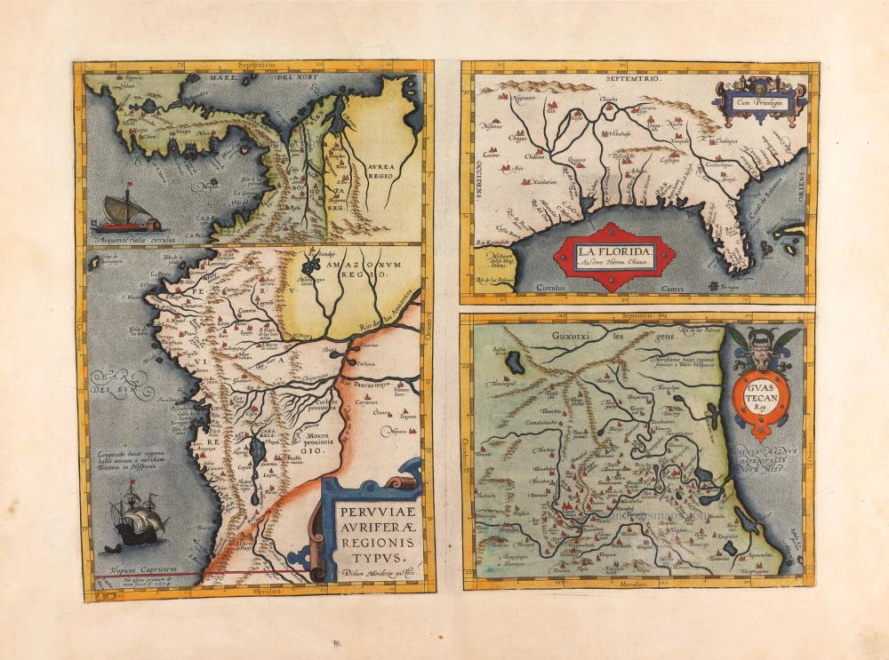
Peruviae Auriferae Regionis Typus. - La Florida - Guastecan ... 1595
Florida, Peru and Mexico by Abraham Ortelius.
[Item number: 29711]

Temistitan - [Above map :] Descrittione della Gran Citta e Isola Temistitan. 1590
Mexico City by Tommaso Porcacchi.
[Item number: 29826]

SCARCE !
S. Francisco de Campeche. 1685/90
View of Mexico - Campeche, by Carel Allard.
[Item number: 30577]
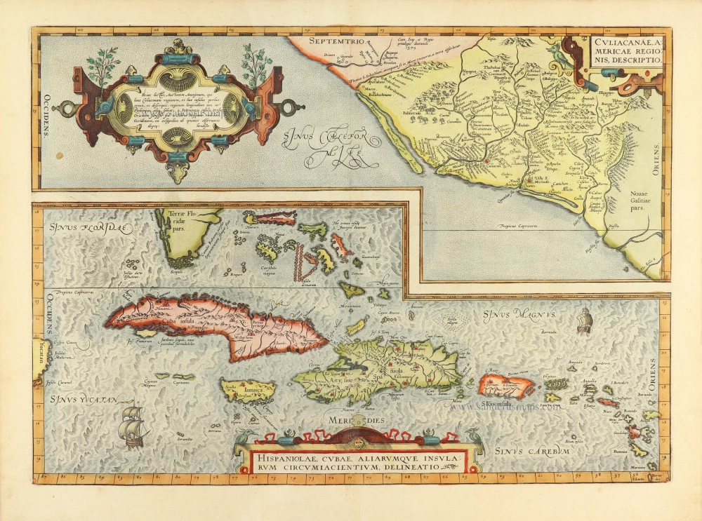
Culiacanae Americae Regionis Descriptio. - Hispaniolae, Cubae, Aliarumquae Insularum Circumiacentium, delineatio. 1584
Antilles by Abraham Ortelius.
[Item number: 30904]
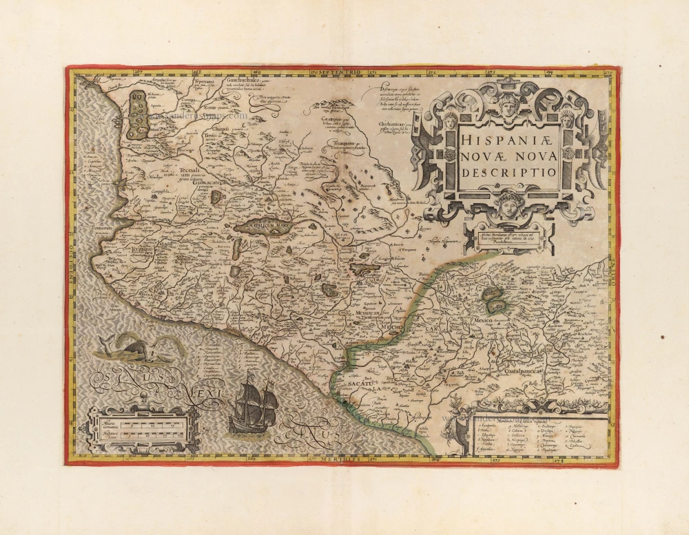
Hispaniae Novae Nova Descriptio. c. 1610-1650
New Spain (Mexico) by Jodocus Hondius.
[Item number: 31323]