
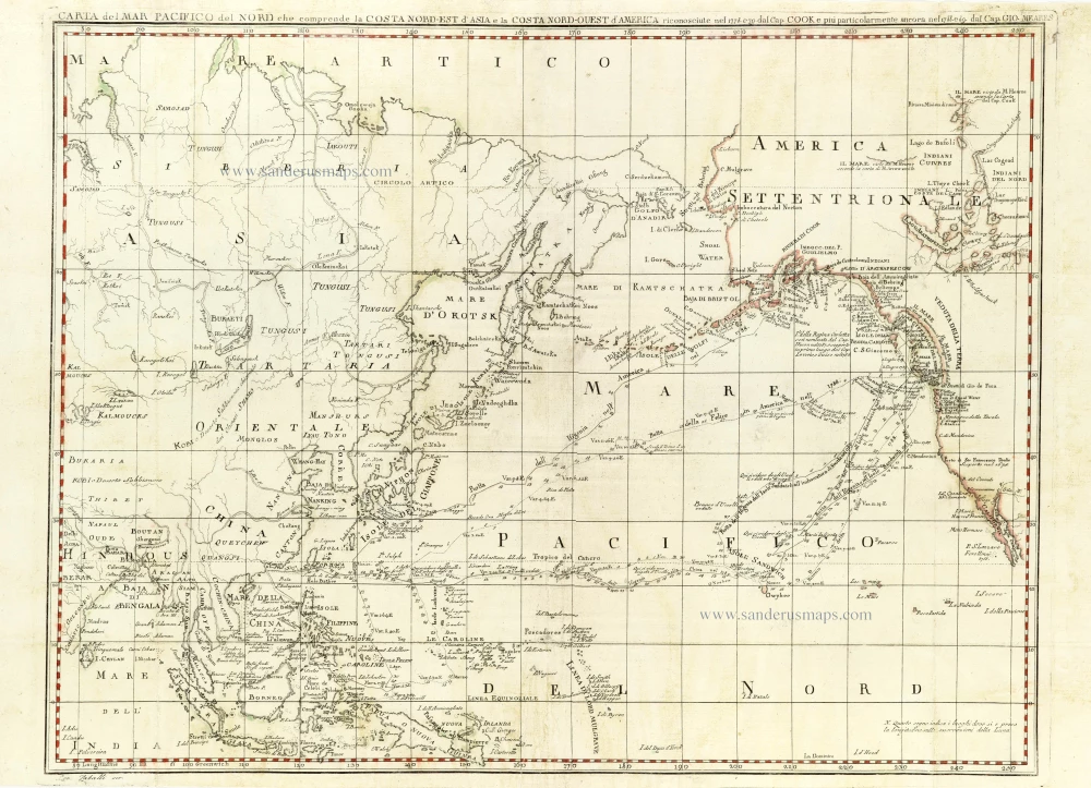
Chart of the Northern Pacific Ocean, Northeastern Asia, and Alaska by John Meares. 1796
John Meares (c. 1756-1809)
John Meares, a renowned English navigator, explorer, and maritime fur trader, is most notably associated with the Nootka Crisis. This pivotal event nearly sparked a war between Britain and Spain. This crisis, a turning point in Meares' life and career, underscored the fierce competition between the two nations for control over the lucrative fur trade on the Northwest Coast. Meares' involvement in this crisis showcased his strategic insight and highlighted the high stakes in British maritime interests in the region.
He entered the Royal Navy in 1771 and was promoted to lieutenant in 1778. After leaving the navy in 1783, Meares formed a company that traded furs on the Northwest Coast. His first trading voyage to Prince William's Sound, Alaska, was tragic, as many sailors died from scurvy. In 1788, Meares sailed with two ships to Nootka, where he built a temporary trading post and North West America, the first ship built on what is now Canada's West Coast. In 1789, Meares formed a company with other British entrepreneurs and sent three ships to make a permanent trading post at Nootka and to trade widely on the Northwest Coast. They found Nootka occupied by a Spanish naval force which seized the British ships and crews. Meares was an effective propagandist in promoting British political and economic interests on the Northwest Coast.
Carta del Mar Pacifico del Nord che comprende la Costa Nord-Ouest d'America
Item Number: 30731 Authenticity Guarantee
Category: Antique maps > America > North America
Chart of the Northern Pacific Ocean, Northeastern Asia, and Alaska by John Meares.
Title: Carta del Mar Pacifico del Nord che comprende la Costa Nord-Ouest d'America
riconosciute nel 1778. e 79. dal Cap. Cook e piu particularmente ancora nel 1788. e 89. dam Cap. Gio. Meares.
Date of the first edition: 1795.
Date of this map: 1796.
Copper engraving, printed on paper.
Image size: 420 x 545mm (16.54 x 21.46 inches).
Sheet size: 435 x 630mm (17.13 x 24.8 inches).
Verso: Blank.
Condition: Backed.
Condition Rating: A.
From: Viaggi dalla China alla costa nord-ovest d'America fatti negli anni 1788 e 1789 dal Capitano G. Meares. Napoli, 1796.
John Meares (c. 1756-1809)
John Meares, a renowned English navigator, explorer, and maritime fur trader, is most notably associated with the Nootka Crisis. This pivotal event nearly sparked a war between Britain and Spain. This crisis, a turning point in Meares' life and career, underscored the fierce competition between the two nations for control over the lucrative fur trade on the Northwest Coast. Meares' involvement in this crisis showcased his strategic insight and highlighted the high stakes in British maritime interests in the region.
He entered the Royal Navy in 1771 and was promoted to lieutenant in 1778. After leaving the navy in 1783, Meares formed a company that traded furs on the Northwest Coast. His first trading voyage to Prince William's Sound, Alaska, was tragic, as many sailors died from scurvy. In 1788, Meares sailed with two ships to Nootka, where he built a temporary trading post and North West America, the first ship built on what is now Canada's West Coast. In 1789, Meares formed a company with other British entrepreneurs and sent three ships to make a permanent trading post at Nootka and to trade widely on the Northwest Coast. They found Nootka occupied by a Spanish naval force which seized the British ships and crews. Meares was an effective propagandist in promoting British political and economic interests on the Northwest Coast.
Related items

Carte de l'Ocean Pacifique au Nord de l'Equateur, et des Cotes qui le Bornent des Deux Cotes: D'Apres les Dernieres Decouvertes Faites par les Espagnols, les Russes et les Anglois, jusqu'en 1780. 1780
The Northern Pacific Ocean, by T.C. Lotter.
[Item number: 11984]

Carte des Nouvelles Decouvertes au Nord de la Mer du Sud, tant à l'Est de la Sibérie et du Kamtchatka, qu'à l'Ouest de la Nouvelle France. 1776-79
Pacific Ocean (North) by Francesco & Paolo Santini
[Item number: 26979]

California as an island
Atlantis Insula. 1692
The Americas by Guillaume Sanson.
[Item number: 28376]

Important map
Maris Pacifici, (quod vulgo Mar del Zur) cum regionibus circumiacentibus, insulisque in codem passim sparsis, novissima descriptio. 1603
Pacific Ocean by Abraham Ortelius.
[Item number: 33069]
new