
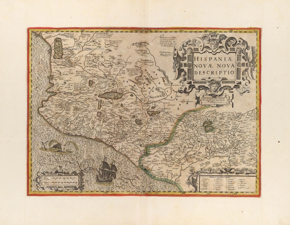
Mexico, by Petrus Bertius. 1618

Petrus Bertius (1565-1629)
Petrus Bertius, born at Beveren, Flanders, in 1565, was related to Pieter van den Keere (Kaerius) and Jodocus Hondius. Both famous cartographers were brothers-in-law of Petrus Bertius. As a refugee, he settled in Amsterdam, and after finishing his studies, he became a professor of mathematics and librarian at the University of Leiden. In 1618, he became a cosmographer and historiographer for Louis XIII of France. He lived in Paris, where he died in 1629.
Petrus Bertius's remarkable work ethic is evident in the numerous geographical and theological works he produced. His contributions to the works of Clüver and Herrera further solidified his reputation in geography.
His fame among geographers was established by his text in the pocket atlas Tabularum Geographicarum and by his edition of Ptolemy’s Geographia.
The origin of the Tabularum Geographicum lies in the well-known miniature atlas Caert thresoor, published by Barent Langenes in 1598 in Middelburg. Bertius engraved 169 maps for this small but attractive atlas, sold for the first time in 1599 by Cornelis Claesz in Amsterdam. In 1600, Claesz published the pocket atlas with a Latin text composed by Petrus Bertius. From then on, new editions, often enlarged with new maps, regularly appeared, subsequently published by Cornelis Claesz, Jodocus Hondius, Johannes Janssonius and ultimately, in 1649, by Claes Jansz. Visscher.
Koeman divides this series of pocketbooks into two atlases: The Caert-thresoor, published by Langenes and Claesz., with five editions between 1598 and 1609, and the Tabularum Geographicarum Contractarum by Petrus Bertius with ten editions between 1600 and 1650.
Nova Hispania
Item Number: 32337 Authenticity Guarantee
Category: Antique maps > America > North America
Mexico, by Petrus Bertius.
Title: Nova Hispania
Date of the first edition: 1616.
Date of this map: 1618.
Copper engraving, printed on paper.
Image size: 95 x 130mm (3¾ x 5 inches).
Sheet size: 120 x 185mm (4¾ x 7¼ inches).
Verso: French text.
Condition: Excellent.
Condition Rating: A+.
From: Bertius P. La Geographie Racourcie de Pierre Bertius. Amsterdam, Jodocus Hondius jr. 1618. (Van der Krogt 3, 342:11)
Petrus Bertius (1565-1629)
Petrus Bertius, born at Beveren, Flanders, in 1565, was related to Pieter van den Keere (Kaerius) and Jodocus Hondius. Both famous cartographers were brothers-in-law of Petrus Bertius. As a refugee, he settled in Amsterdam, and after finishing his studies, he became a professor of mathematics and librarian at the University of Leiden. In 1618, he became a cosmographer and historiographer for Louis XIII of France. He lived in Paris, where he died in 1629.
Petrus Bertius's remarkable work ethic is evident in the numerous geographical and theological works he produced. His contributions to the works of Clüver and Herrera further solidified his reputation in geography.
His fame among geographers was established by his text in the pocket atlas Tabularum Geographicarum and by his edition of Ptolemy’s Geographia.
The origin of the Tabularum Geographicum lies in the well-known miniature atlas Caert thresoor, published by Barent Langenes in 1598 in Middelburg. Bertius engraved 169 maps for this small but attractive atlas, sold for the first time in 1599 by Cornelis Claesz in Amsterdam. In 1600, Claesz published the pocket atlas with a Latin text composed by Petrus Bertius. From then on, new editions, often enlarged with new maps, regularly appeared, subsequently published by Cornelis Claesz, Jodocus Hondius, Johannes Janssonius and ultimately, in 1649, by Claes Jansz. Visscher.
Koeman divides this series of pocketbooks into two atlases: The Caert-thresoor, published by Langenes and Claesz., with five editions between 1598 and 1609, and the Tabularum Geographicarum Contractarum by Petrus Bertius with ten editions between 1600 and 1650.
Related items

Nova Hispania et Nova Galicia 1646-57
Mexico by Johannes Janssonius.
[Item number: 10184]
new

Hispaniae Novae sive Magnae Vera Descriptio. 1608
Mexico, by Quad M.-Bussemacher J.
[Item number: 15869]

Hispaniae Novae sivae Magnae, recens et vera descriptio. 1612
New Spain (Mexico) by Abraham Ortelius.
[Item number: 23112]

Hispaniae Novae sivae Magnae, recens et vera descriptio. 1579. 1595
New Spain (Mexico) by Abraham Ortelius.
[Item number: 26297]

Hispania Nova. 1607
Mexico, by C. van Wytfliet.
[Item number: 26501]

Carte du Mexique, et de la Nouvelle Espagne, Contenant la Partie Australe de l'Amérique Septentle. 1776-79
Mexico, by Paolo Santini.
[Item number: 27009]

Hispaniae Novae Nova Descriptio. 1623
New Spain (Mexico) by Jodocus Hondius.
[Item number: 27817]

Mexico sive N. Hispania. 1661
Mexico, by Pierre Duval.
[Item number: 27839]
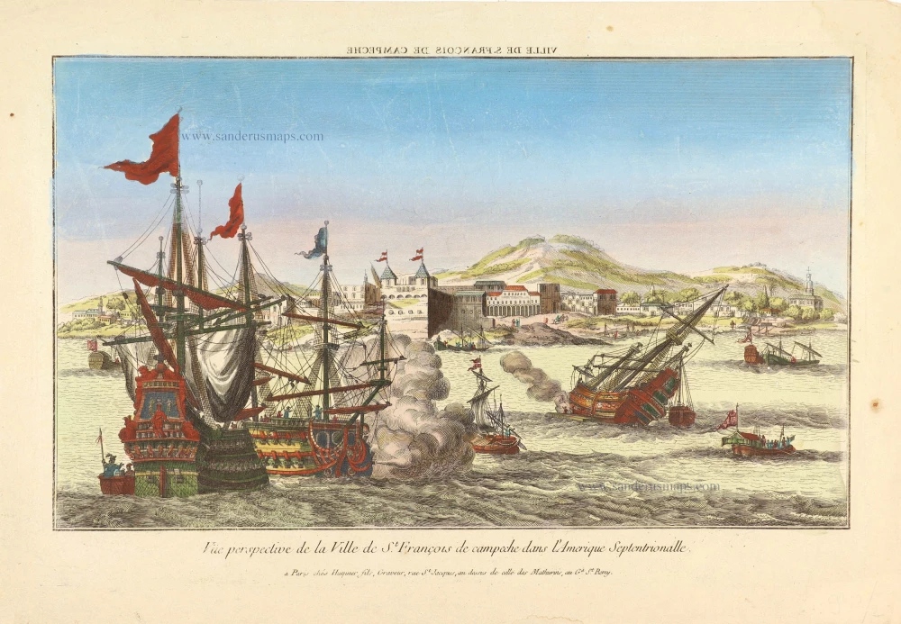
Vue prespective de la Ville de St. François de campech dans L'Amerique Septentrionalle. ca. 1780
Perspective view of a naval battle off the town of St. François (Campeche - Mexico).
[Item number: 28994]

Mexicana. 1602
Mexico, Texas & Florida by Bertius Petrus
[Item number: 29492]
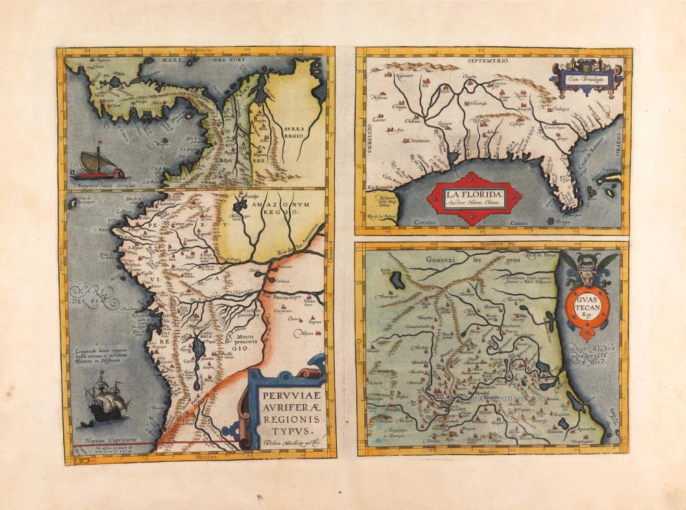
Peruviae Auriferae Regionis Typus. - La Florida - Guastecan ... 1595
Florida, Peru and Mexico by Abraham Ortelius.
[Item number: 29711]

Temistitan - [Above map :] Descrittione della Gran Citta e Isola Temistitan. 1590
Mexico City by Tommaso Porcacchi.
[Item number: 29826]

Very rare.
Portus Acapulco. 1685/90
View of Acapulco (Mexico) by Carel Allard.
[Item number: 30548]

SCARCE !
S. Francisco de Campeche. 1685/90
View of Mexico - Campeche, by Carel Allard.
[Item number: 30577]
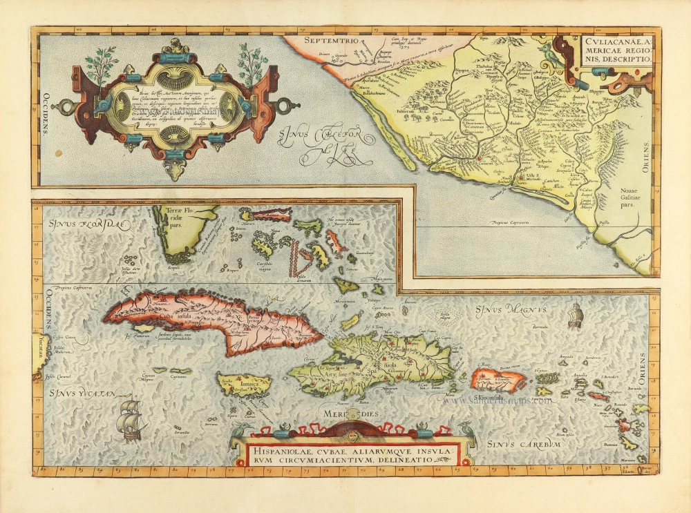
Culiacanae Americae Regionis Descriptio. - Hispaniolae, Cubae, Aliarumquae Insularum Circumiacentium, delineatio. 1584
Antilles by Abraham Ortelius.
[Item number: 30904]
Hispaniae Novae Nova Descriptio. c. 1610-1650
New Spain (Mexico) by Jodocus Hondius.
[Item number: 31323]

Mexico 1618
Mexico City, by Petrus Bertius.
[Item number: 32336]

Nova Hispania et Nova Galicia. 1640
Mexico by Willem Blaeu.
[Item number: 32827]