
Hudson Bay by Hessel Gerritz 1612
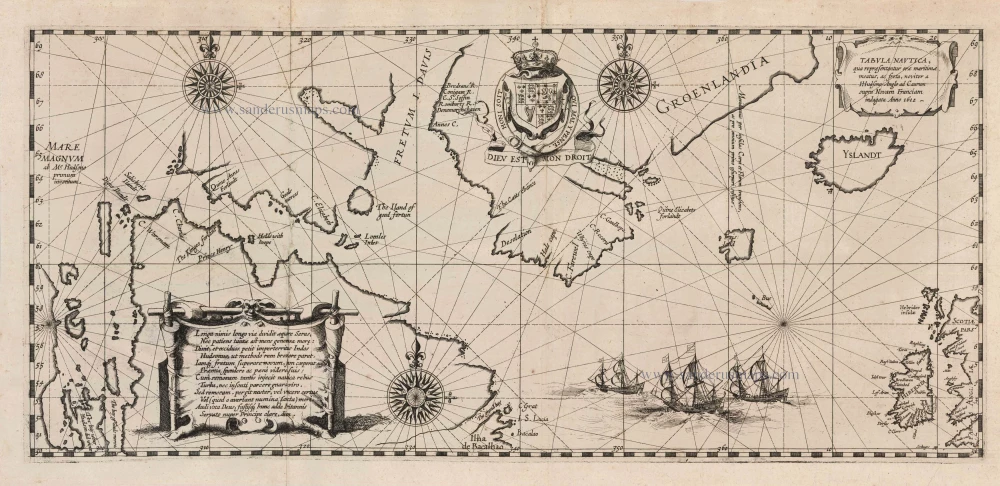
"This scarce map is the first to depict Hudson Bay. It is found in the first printed record of Henry Hudson's fourth and final voyage. The career of Hessel Gerritsz, although apprenticed to Willem Jansz. (Blaeu), flourished before that of his master. Gerritsz became the official cartographer of the Dutch East India Company in 1617, and upon his death in 1632, this title passed to Blaeu. Hudson had already made three accomplished voyages of discovery. The first two, in 1607 and 1608, were on behalf of the English Muscovy Company to find a possible North East Passage to China. The third, in the employ of the Dutch East India Company in 1609, led to the discovery of the river named after him. A group of English merchants employed him to follow up on earlier attempts to find a North-West Passage. Hudson had seen Captain George Weymouth's journal recording that during his 1602 voyage, he had briefly entered what was to be Hudson Strait. In April 1610, Hudson set sail in the Discovery, the same ship that carried Weymouth, and after reaching Greenland, eventually worked his way into 'a spacious sea' and discovered Hudson Bay. They wintered south along the eastern shore at the southernmost point of James Bay. After a bitter and cruel winter, the melting ice finally freed the ship in early June, and a few days later, the crew mutinied. The crew set adrift Hudson, his son and seven others in a small open-top boat. They were never heard of again. We have to thank one Abacuck Prickett for the survival of a map. Only eight men made it back to England in September 1611. Not one of them was ever punished. The map somehow made its way to Amsterdam, where in 1612, Gerritz published the first account of the voyage. The printed map records Hudson's belief that he had found the Pacific Ocean with MARE MAGNUM. What, at first glance, looks like the western shore of Hudson Bay is James Bay. It was in 1612 that this coast was traversed with the voyage of Thomas Button. The misconception of James Bay and its two large bays at the southern end would persist for decades. The map was issued first in the Dutch edition and then again in the same year in a Latin version entitled Descriptio ac delineatio geographica detectionis Freti ... Each of these appears in two separate issues. The Latin edition was repeated in 1613, again in two distinct versions. In 1613 Johann Theodore de Bry published the tenth part of his Petit Voyages. Included was a description of Hudson's voyage and a reduced version of this map." (Burden) "Tabula Nautica, the most popular map of its day, sold as fast as Gerritsz could print copies. It was the first public account of what happened to Hudson, the first to show an outline of Hudson's Bay, and, most important, the first to indicate the location of the Northwest Passage. The Hudson chart revealed many things the English wished to keep secret and provided Europeans with the most exciting news since Columbus's voyage." (Douglas McNaughton) "Contemporary sources concerning the expedition's outcome are very scarce, while the original charts and logs were lost. Surprisingly, the most important account of the voyage is not given by an Englishman but by the Amsterdam cartographer and publisher Hessel Gerritz (c.1580-1632). In his treatise Beschryvinghe vander Samoyeden Landt in Tartaryen a 'Tabula Nautica' with Hudson's discoveries has been included. It is the oldest depiction of the Hudson Bay region. Using the English language for many place names reinforces the impression that Hessel Gerritz disposed of the original chart by Hudson, carried away by the mutineers, or of a copy of this chart. The extensive exploration of the east coast of Hudson Bay provides a further investigation of its reliance. At the same time, the coastlines west of 'the bay of Goods Merces' are not open to topographical interpretation. It is not quite clear how Hessel Gerritz succeeded in laying hands on the result of Hudson's last disastrous voyage within such a short time. One has to suppose the involvement of his protector, Plancius, to whom the material was passed by Richard Hakluyt Jr., the English publisher of travel reports, or Emanuel van Meteren (1535-1612), the well-known Dutch historiographer who lived in London. ..." (Schilder).
"This map is the foundation of Canada's basic economic history. It served as the only function chart for the northern regions of Canada for several decades. It enabled the successful establishment of the Hudson Bay Company, which was to dominate trade, exploration and the economic development of Canada for a long period." (Kershaw)
Hessel Gerritsz. (1580/81 – 1632)
Hessel Gerritsz. was one of the seventeenth century's most influential and innovative map makers. He was born in Assum in North Holland and attended Alkmaar school. He must have known Willem Jansz. (= Willem Blaeu) who stayed in Alkmaar for several years. Later, he moved to Amsterdam for his further education.
After the closing of the Scheldt River, Amsterdam’s competitor was cut off so Amsterdam could take over the world trade centre's function. Flourishing Amsterdam offered plenty of work and was an excellent attraction for artisans from the Southern Netherlands. The two dominating publishers in the cartographical field were Cornelis Claesz. and Jodocus Hondius, both from the Southern Netherlands. Hessel Gerritsz. was trained in the graphic trade by David Vingboons, a painter and artist from the Southern Netherlands.
After his apprenticeship with David Vingboons, Hessel Gerritsz. continued his schooling in the publishing house of Willem Jansz. (Blaeu). There, he could perfect his etching style, was given the mathematical skills that would be useful to him later, and learned the trade of mapmaking. With the engraver Josua van den Ende, he was responsible for engraving the superb wall map of the Seventeen Provinces (1608). Van den Ende engraved the map image while Hessel Gerritsz. took care of the decorative borders and the decorations on the main map.
During his activities for Willem Jansz. Hessel Gerritsz. not only perfected his etching and engraving style but also received the geographical and mathematical education that would stand him in good stead in later years. He could not wish for a better cartographical school. Blaeu’s workshop was a repository where geographical information from all parts of the world came together.
Hessel Gerritsz. married in 1607 to Geertje Gijsbertdr. One of his children, Gerrit, born in 1609, was to follow in his father’s footsteps. Shortly after his marriage, he established himself as an independent engraver, mapmaker and printer.
Hessel Gerritsz. regularly worked with Claes Jansz. Visscher, as well. They cooperated for a long time.
His artistic talent comes to the fore in his map of the Leo Belgicus, depicting the Seventeen Provinces in the shape of a lion. This was seen as a symbol of the courage and persistence of the Dutch provinces in their resistance against Spanish tyranny.
In 1612-13, Hessel Gerritsz. was intensively busy with publications about Russia. In 1612, he published the influential booklet Beschryvinghe vander Samoyeden Landt. The two chapters about Siberia were provided by Isaac Massa, who had lived in Moscow for nine years. With the aid of original Russian material, Gerrritsz. produced a series of three maps in folio format: a map of Russia and Moscow and the Kremlin town plans. He also made an essential new wall map of Lithuania and engraved it on four plates for Willem Blaeu. In the meantime, he also made a wall map and a folio map of Spain.
Next to these works undertaken on his initiative, Hessel Gerritsz. also accepted engraving and publishing tasks for third parties.
In 1617, Hessel Gerritsz. published a large wall map of Italy in six sheets. He gave his wall map an extra cachet by extending the map image with town views and costumed figures. The map was copied shortly after publication by Willem Blaeu. To protect himself against such plagiarism in the future, he requested a patent from the States-General. In January 1618, they granted him a general license in which, amongst other things, it was forbidden in any way to reproduce, copy or distribute his maps, both written or printed.
Hessel Gerritsz. was so highly regarded in 1617 that he received such an extraordinary privilege. He was appointed as a geography instructor for the Councillors of the Admiralty at Amsterdam and as a mapmaker for the Chamber Amsterdam of the VOC. With both appointments, his old employer, Willem Blaeu, was passed over. In his function as VOC's mapmaker, he improved and expanded the charts for navigation to and from the Indies. The chart maker, of course, did not draw the charts needed for the VOC ships himself. He manufactured specific prototypes, the so-called leggers (master charts), which served as models for copying work by his assistants in his house.
At the beginning of September 1632, Hessel Gerritsz. died at the age of 52. He must be considered one of the most comprehensive map makers of his time. “He was multi-disciplined in his working method, integrating graphical technique and artistic expression in his scientific approach. Because of his mathematical talent, he could solve nautical problems and make proposals about them. His exceptional network – the interviews with pilots from diverse companies and his correspondence with persons at home and abroad – supplied him with a huge amount of geographical and nautical information that he used most efficiently. His good contacts with the families of the great merchants, ship owners, and the influential regents' representatives opened doors for him. He was, without doubt, the most informed person in geographical matters in Amsterdam of his time.” (Schilder)
Tabula Nautica, qua repraesentantur orae maritimae, meatus, ac freta, noviter a H. Hudsono Anglo ad Caurum supra Novam Franciam indagata Anno 1612.
Item Number: 5599 Authenticity Guarantee
Category: Antique maps > America > North America
Old, antique map of Hudson Bay by Hessel Gerritz.
Title: Tabula Nautica, qua repraesentantur orae maritimae, meatus, ac freta, noviter a H. Hudsono Anglo ad Caurum supra Novam Franciam indagata Anno 1612.
Date of the first edition: 1612.
Date of this map: 1612.
Copper engraving, printed on paper.
Size (not including margins): 240 x 520mm (9.45 x 20.47 inches).
Verso: Blank.
Condition: Small repair at fold with a bit of reinstatement (5mm), else excellent.
Condition Rating: B.
From: Beschryvinghe van der Samoyeden landt in Tatarien. 1612
"This scarce map is the first to depict Hudson Bay. It is found in the first printed record of Henry Hudson's fourth and final voyage. The career of Hessel Gerritsz, although apprenticed to Willem Jansz. (Blaeu), flourished before that of his master. Gerritsz became the official cartographer of the Dutch East India Company in 1617, and upon his death in 1632, this title passed to Blaeu. Hudson had already made three accomplished voyages of discovery. The first two, in 1607 and 1608, were on behalf of the English Muscovy Company to find a possible North East Passage to China. The third, in the employ of the Dutch East India Company in 1609, led to the discovery of the river named after him. A group of English merchants employed him to follow up on earlier attempts to find a North-West Passage. Hudson had seen Captain George Weymouth's journal recording that during his 1602 voyage, he had briefly entered what was to be Hudson Strait. In April 1610, Hudson set sail in the Discovery, the same ship that carried Weymouth, and after reaching Greenland, eventually worked his way into 'a spacious sea' and discovered Hudson Bay. They wintered south along the eastern shore at the southernmost point of James Bay. After a bitter and cruel winter, the melting ice finally freed the ship in early June, and a few days later, the crew mutinied. The crew set adrift Hudson, his son and seven others in a small open-top boat. They were never heard of again. We have to thank one Abacuck Prickett for the survival of a map. Only eight men made it back to England in September 1611. Not one of them was ever punished. The map somehow made its way to Amsterdam, where in 1612, Gerritz published the first account of the voyage. The printed map records Hudson's belief that he had found the Pacific Ocean with MARE MAGNUM. What, at first glance, looks like the western shore of Hudson Bay is James Bay. It was in 1612 that this coast was traversed with the voyage of Thomas Button. The misconception of James Bay and its two large bays at the southern end would persist for decades. The map was issued first in the Dutch edition and then again in the same year in a Latin version entitled Descriptio ac delineatio geographica detectionis Freti ... Each of these appears in two separate issues. The Latin edition was repeated in 1613, again in two distinct versions. In 1613 Johann Theodore de Bry published the tenth part of his Petit Voyages. Included was a description of Hudson's voyage and a reduced version of this map." (Burden) "Tabula Nautica, the most popular map of its day, sold as fast as Gerritsz could print copies. It was the first public account of what happened to Hudson, the first to show an outline of Hudson's Bay, and, most important, the first to indicate the location of the Northwest Passage. The Hudson chart revealed many things the English wished to keep secret and provided Europeans with the most exciting news since Columbus's voyage." (Douglas McNaughton) "Contemporary sources concerning the expedition's outcome are very scarce, while the original charts and logs were lost. Surprisingly, the most important account of the voyage is not given by an Englishman but by the Amsterdam cartographer and publisher Hessel Gerritz (c.1580-1632). In his treatise Beschryvinghe vander Samoyeden Landt in Tartaryen a 'Tabula Nautica' with Hudson's discoveries has been included. It is the oldest depiction of the Hudson Bay region. Using the English language for many place names reinforces the impression that Hessel Gerritz disposed of the original chart by Hudson, carried away by the mutineers, or of a copy of this chart. The extensive exploration of the east coast of Hudson Bay provides a further investigation of its reliance. At the same time, the coastlines west of 'the bay of Goods Merces' are not open to topographical interpretation. It is not quite clear how Hessel Gerritz succeeded in laying hands on the result of Hudson's last disastrous voyage within such a short time. One has to suppose the involvement of his protector, Plancius, to whom the material was passed by Richard Hakluyt Jr., the English publisher of travel reports, or Emanuel van Meteren (1535-1612), the well-known Dutch historiographer who lived in London. ..." (Schilder).
"This map is the foundation of Canada's basic economic history. It served as the only function chart for the northern regions of Canada for several decades. It enabled the successful establishment of the Hudson Bay Company, which was to dominate trade, exploration and the economic development of Canada for a long period." (Kershaw)
Hessel Gerritsz. (1580/81 – 1632)
Hessel Gerritsz. was one of the seventeenth century's most influential and innovative map makers. He was born in Assum in North Holland and attended Alkmaar school. He must have known Willem Jansz. (= Willem Blaeu) who stayed in Alkmaar for several years. Later, he moved to Amsterdam for his further education.
After the closing of the Scheldt River, Amsterdam’s competitor was cut off so Amsterdam could take over the world trade centre's function. Flourishing Amsterdam offered plenty of work and was an excellent attraction for artisans from the Southern Netherlands. The two dominating publishers in the cartographical field were Cornelis Claesz. and Jodocus Hondius, both from the Southern Netherlands. Hessel Gerritsz. was trained in the graphic trade by David Vingboons, a painter and artist from the Southern Netherlands.
After his apprenticeship with David Vingboons, Hessel Gerritsz. continued his schooling in the publishing house of Willem Jansz. (Blaeu). There, he could perfect his etching style, was given the mathematical skills that would be useful to him later, and learned the trade of mapmaking. With the engraver Josua van den Ende, he was responsible for engraving the superb wall map of the Seventeen Provinces (1608). Van den Ende engraved the map image while Hessel Gerritsz. took care of the decorative borders and the decorations on the main map.
During his activities for Willem Jansz. Hessel Gerritsz. not only perfected his etching and engraving style but also received the geographical and mathematical education that would stand him in good stead in later years. He could not wish for a better cartographical school. Blaeu’s workshop was a repository where geographical information from all parts of the world came together.
Hessel Gerritsz. married in 1607 to Geertje Gijsbertdr. One of his children, Gerrit, born in 1609, was to follow in his father’s footsteps. Shortly after his marriage, he established himself as an independent engraver, mapmaker and printer.
Hessel Gerritsz. regularly worked with Claes Jansz. Visscher, as well. They cooperated for a long time.
His artistic talent comes to the fore in his map of the Leo Belgicus, depicting the Seventeen Provinces in the shape of a lion. This was seen as a symbol of the courage and persistence of the Dutch provinces in their resistance against Spanish tyranny.
In 1612-13, Hessel Gerritsz. was intensively busy with publications about Russia. In 1612, he published the influential booklet Beschryvinghe vander Samoyeden Landt. The two chapters about Siberia were provided by Isaac Massa, who had lived in Moscow for nine years. With the aid of original Russian material, Gerrritsz. produced a series of three maps in folio format: a map of Russia and Moscow and the Kremlin town plans. He also made an essential new wall map of Lithuania and engraved it on four plates for Willem Blaeu. In the meantime, he also made a wall map and a folio map of Spain.
Next to these works undertaken on his initiative, Hessel Gerritsz. also accepted engraving and publishing tasks for third parties.
In 1617, Hessel Gerritsz. published a large wall map of Italy in six sheets. He gave his wall map an extra cachet by extending the map image with town views and costumed figures. The map was copied shortly after publication by Willem Blaeu. To protect himself against such plagiarism in the future, he requested a patent from the States-General. In January 1618, they granted him a general license in which, amongst other things, it was forbidden in any way to reproduce, copy or distribute his maps, both written or printed.
Hessel Gerritsz. was so highly regarded in 1617 that he received such an extraordinary privilege. He was appointed as a geography instructor for the Councillors of the Admiralty at Amsterdam and as a mapmaker for the Chamber Amsterdam of the VOC. With both appointments, his old employer, Willem Blaeu, was passed over. In his function as VOC's mapmaker, he improved and expanded the charts for navigation to and from the Indies. The chart maker, of course, did not draw the charts needed for the VOC ships himself. He manufactured specific prototypes, the so-called leggers (master charts), which served as models for copying work by his assistants in his house.
At the beginning of September 1632, Hessel Gerritsz. died at the age of 52. He must be considered one of the most comprehensive map makers of his time. “He was multi-disciplined in his working method, integrating graphical technique and artistic expression in his scientific approach. Because of his mathematical talent, he could solve nautical problems and make proposals about them. His exceptional network – the interviews with pilots from diverse companies and his correspondence with persons at home and abroad – supplied him with a huge amount of geographical and nautical information that he used most efficiently. His good contacts with the families of the great merchants, ship owners, and the influential regents' representatives opened doors for him. He was, without doubt, the most informed person in geographical matters in Amsterdam of his time.” (Schilder)