
Old, antique map of the east coast of the U.S. by Doncker H. 1660


"The map is largely derived from Colom's chart, although with some omissions and additions. The key to the various names of the Hudson River is left out, as is the duplicate use of Jamestown. Amongst the new nomenclature can be found Gilfort on the north shore of Long Island Sound. The coastline is virtually identical with the exception of that part south of Cape Henry, where at first glance he appears to draw upon Jacobsz, until one notices Chesipiook at the northern end of the Outer Banks. This usage dates back to those derived from the de Bry-White map of 1590." (Burden)
First state with the date 1660 in the cartouche.
Hendrick Doncker (1625-1699)
Hendrick Doncker became a member of the bookseller's guild in 1647 and ran his shop successfully for fifty years. He was able to develop one of the most popular sets of maritime works published in Amsterdam during the Golden Age.
In 1651 he bought a house in the Nieuwe Brugsteeg in Amsterdam. It was called 'in 't Stuurmans gereetschap' (in the mariners' instruments) and stood opposite the house where Johannes van Keulen later settled.
Apart from the sea atlases, charts and pilot books, Hendrik Doncker published various editions of textbooks on the art of navigation.
After the death of Hendrick Doncker, the son, Hendrick II (c. 1664-c.1739), continued publishing the sea atlases Zeeatlas and Zeespiegel until 1708.
Doncker's charts were the most up-to-date in the second half of the 17th century. Although there is some similarity to those charts published by Van Loon, Goos, Lootsman, and Doncker, the latter's charts are original.
In 1655, Hendrick Doncker had begun with the publication of a pilot guide, the Lichtende Columne ofte Zeespiegel. In 1659 he published his first sea atlas, the Zee-Atlas of Waeter-waereld, with 19 maps. Between 1659 and 1669, he increased the number of charts from 19 to 30 and in 1669 he came with an edition containing 50, which was soon to be followed by an edition with large maps: the Nieuwe Groote Vermeerderde Zeeatlas, also with 50 charts. This beautiful atlas was reprinted and continually improved for more than 25 years. After the death of Hendrick Doncker in 1699, his son continued the publication and even enlarged and enhanced the sea-atlas.
Pascaert van Nieu Nederland, Virginia en Nieu Engelant
Item Number: 18577 Authenticity Guarantee
Category: Antique maps > America > North America
Old antique sea chart of the east coast of the U.S. by H. Doncker.
Date of the first edition: 1660
Date of this map: 1660
Copper engraving
Size: 44 x 54cm (17.2 x 21.1 inches)
Verso: Blank
Condition: Contemporary old coloured, backed with paper as issued, trimmed and remargined at bottom, with some reinstatement to neatline (3-5mm).
Condition Rating: C
References: Burden, 348 State 1, Koeman, Don8A [18].
From: De Zee-Atlas Ofte Water-Waereld, Vertoonende all de Zee-Kusten Van het bekende Deel des Aerd-Bodems, ... Amsterdam, 1660. (Koeman, Don2)
"The map is largely derived from Colom's chart, although with some omissions and additions. The key to the various names of the Hudson River is left out, as is the duplicate use of Jamestown. Amongst the new nomenclature can be found Gilfort on the north shore of Long Island Sound. The coastline is virtually identical with the exception of that part south of Cape Henry, where at first glance he appears to draw upon Jacobsz, until one notices Chesipiook at the northern end of the Outer Banks. This usage dates back to those derived from the de Bry-White map of 1590." (Burden)
First state with the date 1660 in the cartouche.
Hendrick Doncker (1625-1699)
Hendrick Doncker became a member of the bookseller's guild in 1647 and ran his shop successfully for fifty years. He was able to develop one of the most popular sets of maritime works published in Amsterdam during the Golden Age.
In 1651 he bought a house in the Nieuwe Brugsteeg in Amsterdam. It was called 'in 't Stuurmans gereetschap' (in the mariners' instruments) and stood opposite the house where Johannes van Keulen later settled.
Apart from the sea atlases, charts and pilot books, Hendrik Doncker published various editions of textbooks on the art of navigation.
After the death of Hendrick Doncker, the son, Hendrick II (c. 1664-c.1739), continued publishing the sea atlases Zeeatlas and Zeespiegel until 1708.
Doncker's charts were the most up-to-date in the second half of the 17th century. Although there is some similarity to those charts published by Van Loon, Goos, Lootsman, and Doncker, the latter's charts are original.
In 1655, Hendrick Doncker had begun with the publication of a pilot guide, the Lichtende Columne ofte Zeespiegel. In 1659 he published his first sea atlas, the Zee-Atlas of Waeter-waereld, with 19 maps. Between 1659 and 1669, he increased the number of charts from 19 to 30 and in 1669 he came with an edition containing 50, which was soon to be followed by an edition with large maps: the Nieuwe Groote Vermeerderde Zeeatlas, also with 50 charts. This beautiful atlas was reprinted and continually improved for more than 25 years. After the death of Hendrick Doncker in 1699, his son continued the publication and even enlarged and enhanced the sea-atlas.
Related items
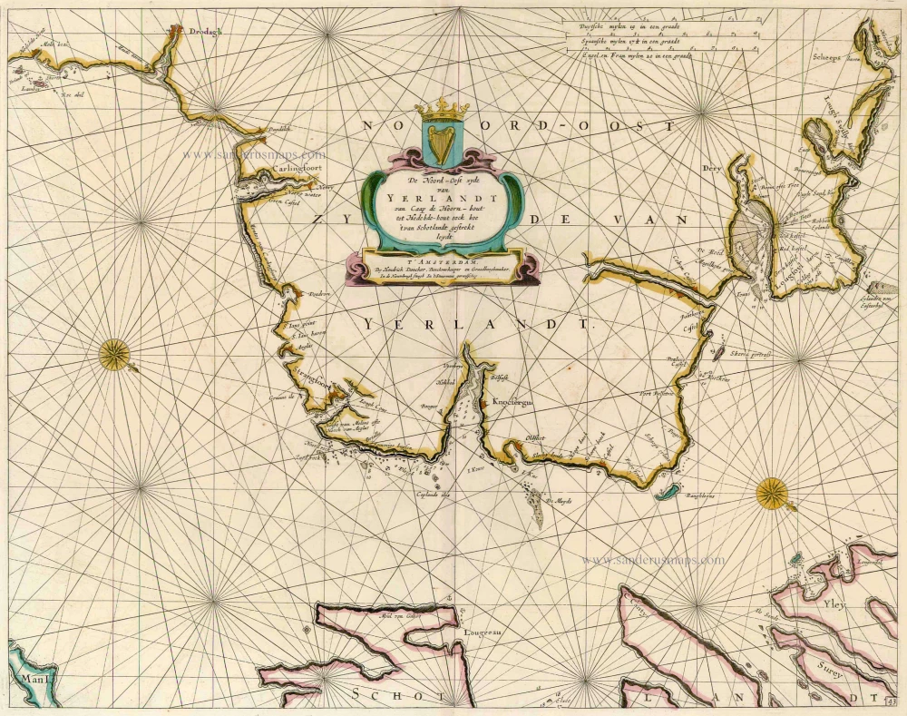
De Noord-Oost zyde van Yerlandt van Caap de Hoorn-hout tot Hedehde-hout oock hoe 't van Schotlandt gestrekt leydt 1686
Ireland, by Doncker H.
[Item number: 13644]
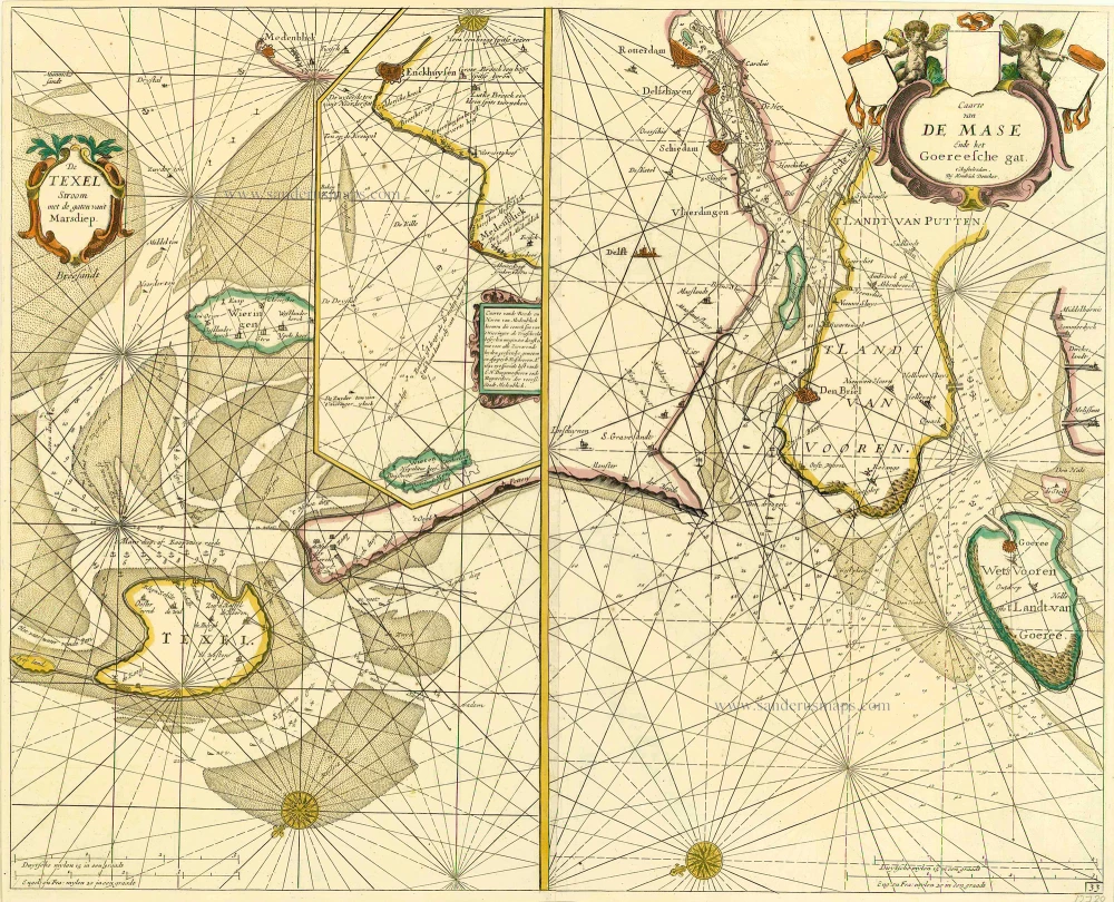
De Texel Stroom met de gaten vant Marsdiep. [On sheet with:] Caarte van De Mase ende het Goereesche Gat 1686
Texel & Maas, by Doncker H.
[Item number: 13738]
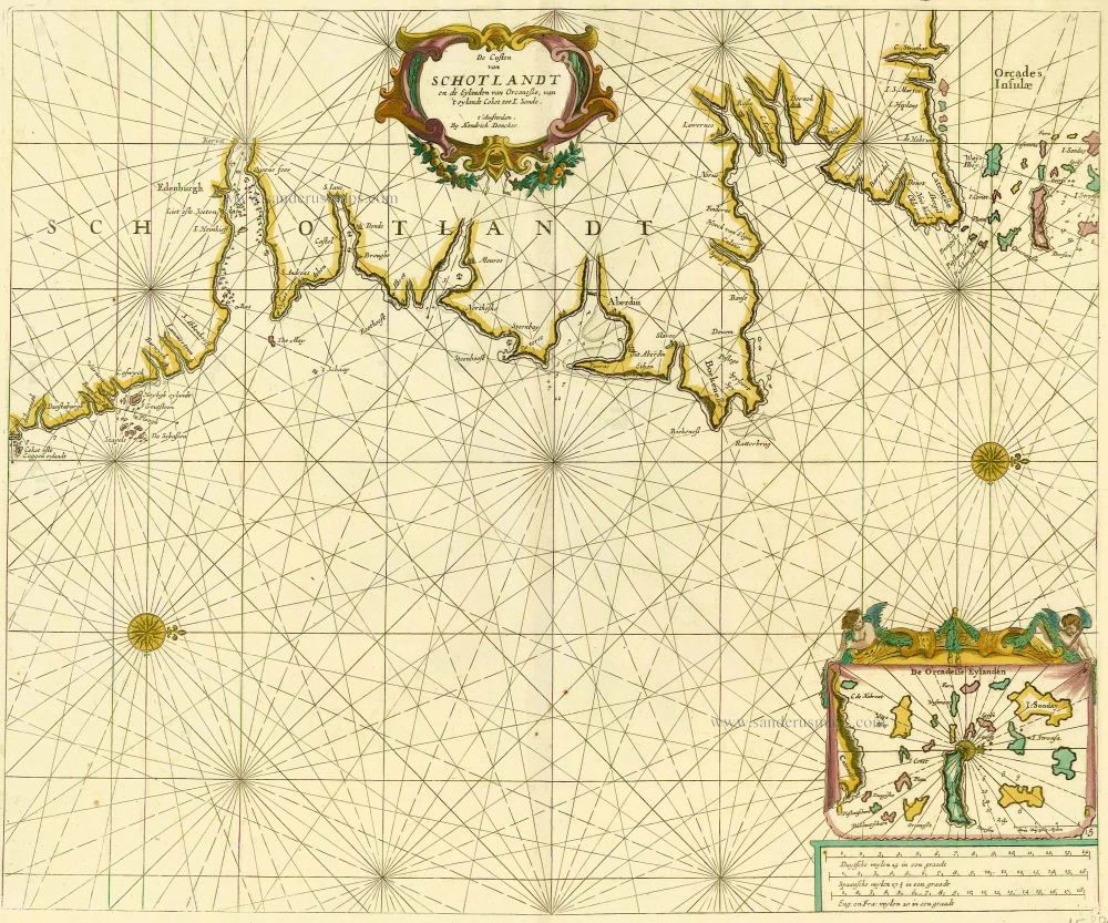
De Custen van Schotlandt en de Eylanden van Orcanese, van 't eylandt Coket tot I. Sande. 1686
Scotland and Orkney Islands, by Doncker H.
[Item number: 15386]
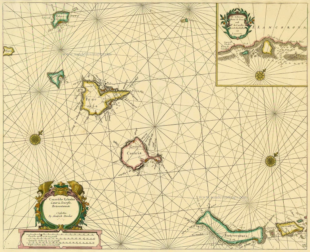
Canarische Eylanden Canaria Tenerifa, Forteventura etc. t' Amsterdam, 1686
Canary Islands, by Hendrick Doncker.
[Item number: 15419]
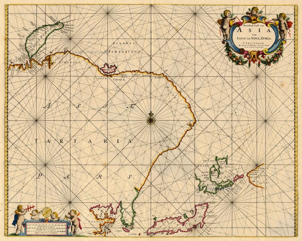
Noordoost Cust van Asia van Iapan tot Nova Zemla 1688
Northeast Asia, by Doncker H.
[Item number: 18466]
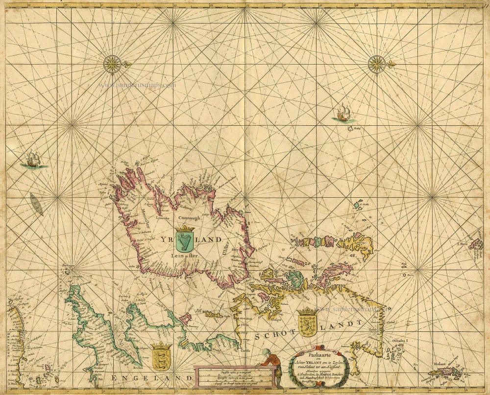
Paskaarte om achter Yrlant om te Zeylen van Hitlant tot aen Heyssant. 1665
British Isles, by Hendrik Doncker.
[Item number: 18567]
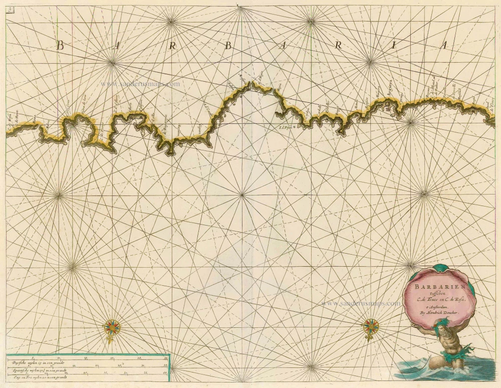
Barbarien tusschen C. de Tenes en C. de Rosa. t' Amsterdam, By Hendrick Doncker. 1664
Northern Africa, by Doncker H.
[Item number: 21375]