
Guiana by Nicolas Sanson. 1658

SANSON FAMILY
Nicolas Sanson (1600-1667) - Guillaume Sanson (1633-1703) - Pierre Moullart-Sanson (? -1730)
Originally from Abbeville, Nicolas I Sanson showed a keen interest in historical geography. He was still very young; he published a map of ancient Gaul and two treatises, Britannia and Portus Itius on Abbeville and Boulogne's origins. His meeting with Melchior Tavernier was decisive: it prompted him to give up his duties as a military engineer in Picardy and devote himself to engraved cartography.
At the same time, Sanson had drawn up the outline of modern France. He got the help of Tavernier, who encouraged him to compete with the Dutch map publishers. Tavernier contacted other French cartographers whose works he published.
From 1643, N. Sanson obtained a privilege to publish a work personally, the Princes souverains de l'Italie. Then, in 1644 and 1645, he had his famous geographical tables printed, which significantly contributed to his fame. He also published a series of atlases in quarto of the four continents.
In 1648, N. Sanson associated himself with Mariette to publish atlases. From then on, specific maps bore his name and others Mariette's. N. Sanson and Mariette worked together for more than 20 years. After the death of N. Sanson, Mariette acquired the entire fund. Since Mariette only wanted to publish complete atlases, individual maps were no longer sold, and some army generals complained to the king.
The disagreement between the Sanson family and Pierre II Mariette culminated in 1671 when Guillaume Sanson took the case to court. There was no longer any question of collaboration: Guillaume Sanson started working for another publisher, Alexis-Hubert Jaillot.
The Sanson family faced financial difficulties, and in 1692, their cousin, Pierre Moullart-Sanson, bought the entire geographic fund from his uncles and aunt. Pierre Moullart-Sanson was the son of Françoise Sanson (third child of Nicolas) and Pierre Moullart. He restarted the publishing of Sanson's world atlas, and in 1704 he acquired a privilege for publishing all the works of Nicolas and Guillaume Sanson, which continued to be published until 1730.
Pierre Mariette (1602-1658)
Bookseller, printseller, printer, and publisher, located in the Rue Saint-Jacques in Paris. On February 12, 1644, Pierre Mariette acquired most of Melchior Tavernier's fund. In 1646, he had a series of maps by Blaeu copied and asked Abraham Peyrounin to engrave them. In the meantime, he published the works of Nicolas Sanson. In 1650, he published the atlas Théâtre Géographique de France. A second edition followed in 1653. He later contributed to Sanson's atlas, the Cartes générales de toutes les parties du monde. Many maps of Mariette's Théatre appeared in later editions of Sanson's Cartes générales.
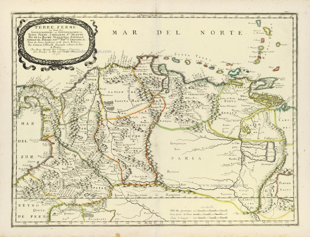
Partie de Terre Ferme ou sont Guiane et Caribane.
Item Number: 28504 Authenticity Guarantee
Category: Antique maps > America > South America
Old, antique map of Northeastern South America, by Nicolas Sanson
Shows the coasts of Guiana, Suriname, French Guiana, and the estuary of the Amazon River.
Title: Partie de Terre Ferme ou sont Guiane et Caribane.
Augmentée et Corrigé suivant les dernieres Relations.
Par N. Sanson d'Abbeville Geographe ord[inaire]re du Roy.
A Paris, Chez P. Mariette, rue St Iacque a l'Esperance avecq privilege du Roy pour vingt Ans.
1656.
Engraver: Jean Somer.
Date of the first edition: 1658.
Date of this map: 1658.
Date on map: 1656.
Copper engraving, printed on paper.
Map size: 405 x 540mm (15.94 x 21.26 inches).
Sheet size: 445 x 605mm (17.52 x 23.82 inches).
Verso: Blank.
Condition: Original coloured in outline, excellent.
Condition Rating: A+.
References: Pastoureau, Sanson V A, p. 406 [92]
From: Cartes generales de toutes les parties du monde, ou les empires, monarchies, republiques, estats, peuples,&c. le l'Asie, de l'Afrique, de l'Europe, & de l'Amerique, ... Par le Sieur d'Abbeville, A Paris, chez l'auteur, ... Et chez Pierre Mariette, M.DC.LVIII [1658]. (Pastoureau, Sanson V A 1658).
SANSON FAMILY
Nicolas Sanson (1600-1667) - Guillaume Sanson (1633-1703) - Pierre Moullart-Sanson (? -1730)
Originally from Abbeville, Nicolas I Sanson showed a keen interest in historical geography. He was still very young; he published a map of ancient Gaul and two treatises, Britannia and Portus Itius on Abbeville and Boulogne's origins. His meeting with Melchior Tavernier was decisive: it prompted him to give up his duties as a military engineer in Picardy and devote himself to engraved cartography.
At the same time, Sanson had drawn up the outline of modern France. He got the help of Tavernier, who encouraged him to compete with the Dutch map publishers. Tavernier contacted other French cartographers whose works he published.
From 1643, N. Sanson obtained a privilege to publish a work personally, the Princes souverains de l'Italie. Then, in 1644 and 1645, he had his famous geographical tables printed, which significantly contributed to his fame. He also published a series of atlases in quarto of the four continents.
In 1648, N. Sanson associated himself with Mariette to publish atlases. From then on, specific maps bore his name and others Mariette's. N. Sanson and Mariette worked together for more than 20 years. After the death of N. Sanson, Mariette acquired the entire fund. Since Mariette only wanted to publish complete atlases, individual maps were no longer sold, and some army generals complained to the king.
The disagreement between the Sanson family and Pierre II Mariette culminated in 1671 when Guillaume Sanson took the case to court. There was no longer any question of collaboration: Guillaume Sanson started working for another publisher, Alexis-Hubert Jaillot.
The Sanson family faced financial difficulties, and in 1692, their cousin, Pierre Moullart-Sanson, bought the entire geographic fund from his uncles and aunt. Pierre Moullart-Sanson was the son of Françoise Sanson (third child of Nicolas) and Pierre Moullart. He restarted the publishing of Sanson's world atlas, and in 1704 he acquired a privilege for publishing all the works of Nicolas and Guillaume Sanson, which continued to be published until 1730.
Pierre Mariette (1602-1658)
Bookseller, printseller, printer, and publisher, located in the Rue Saint-Jacques in Paris. On February 12, 1644, Pierre Mariette acquired most of Melchior Tavernier's fund. In 1646, he had a series of maps by Blaeu copied and asked Abraham Peyrounin to engrave them. In the meantime, he published the works of Nicolas Sanson. In 1650, he published the atlas Théâtre Géographique de France. A second edition followed in 1653. He later contributed to Sanson's atlas, the Cartes générales de toutes les parties du monde. Many maps of Mariette's Théatre appeared in later editions of Sanson's Cartes générales.
Related items

Guiana Sive Amazonum Regio. 1633
Guyana by H. Hondius.
[Item number: 7558]

Guiana sive Amazonum Regio. 1673
Guiana, by A. Montanus.
[Item number: 12480]

Pas-Kaart vande Rivieren Commewini Suriname en Cupanama. 1697-1709
Suriname by J. Van Keulen.
[Item number: 13692]

Guiana Sive Amazonum Regio 1654-1662
Guiana, by J. Blaeu.
[Item number: 14719]

Landkaart van het Eiland en de Volkplanting van Cayenne aan de Kust van Zuid-Amerika c. 1770
Guiana - Cayenne, by Tirion I.
[Item number: 19192]

Very rare first state
Neuwe Landtaffel, in welcher eigentlich, und warhafftiglich furgestelt wird, das gewaltige und goldtreiche Kunigreich Guiana : so daligt under der aequinoctial Linien zwischer Brasilien und Peru / observiert und abgerisen von ein emschiffman so selbst mit her Ralegh der fahrt gewessen. 1599
Guyana by Theodor de Bry.
[Item number: 27037]
Terre Ferme ou sont les Governations, ou Gouvernemens de Terre Ferme, Cartagene, Ste. Marthe, Rio de la Hache, Venezuela, Nouvelle Andalusie, Popayan, Nouveau Roy[au]me de Grenade, &c. 1658
Northern South America by Nicolas Sanson.
[Item number: 28505]

d'Engelze Volkplanting in't Amerikaans gewest Gujana, en Rio de Las Amazones, Door de Scheeps-togt van Charles Leig begonnen. 1707
Guyana, Suriname, and the Lesser Antilles, by Pieter Van der Aa.
[Item number: 32403]

First edition
Terra Firma Et Novum Regnum Granatense Et Popayan. 1630
Colombia by Willem Blaeu.
[Item number: 32531]

L' America Meridionale. 1677
South America by Nicolas Sanson, published by Giovanni de Rossi.
[Item number: 32897]