
Rare and interesting map
Voyage of Magellan from Spain to Asia, by Pieter Van der Aa. 1707

Shows California as an island, and includes the partial coastline of New Zealand (Nova Zelandia), Australia (Nova Hollandia and Quiri Regio), New Guinea (Nova Guinea), and Tasmania (Van Diemens Lant). In South America, the mythical, equatorial Lake Parime is shown in Guyana with the golden city of Manoa on its western shore, and Lago de los Xarayes appears in the centre of the continent.
Pieter van der Aa (Leiden, 1659-1733)
Pieter van der Aa was already in 1682 owner of a bookshop and auction house. During his life, he has published an enormous amount of printed material.
After 1700, van der Aa increasingly specialised in books on geography and travel.
He published composite atlases, a series of geographical descriptions of European countries, and some very spectacular works. Between 1706 and 1708 he published the Naauweurige versameling der gedenkwaardigste zee- en land-reysen, in 28 volumes.
Many of Van der Aa’s publications are richly illustrated with maps and plates. He took over many copperplates and prints from other publishers such as Carel Allard and Frederik De Wit. The composite atlases that appeared from his workshop contain a curious mixture of his own material, copies of maps from other publishers, and reprints made from old copper plates, now with his own imprint.
The Galérie agréable du monde, was completed in 1729, and comprised 66 parts, bound in 27 volumes. Van der Aa presented it as a good investment; after publication, the antiquarian value of the work would double, the more so since it was printed in a limited edition of only one hundred copies.
Scheeps-Togt door Ferdinand Magellaan uit Kastilien gedaan na R. de la Plata en van daar door zyn ontdekte straat tot aan de Moluccas.
Item Number: 32347 Authenticity Guarantee
Category: Antique maps > America > The Americas
Voyage of Magellan from Spain to Asia, by Pieter Van der Aa.
Title: Scheeps-Togt door Ferdinand Magellaan uit Kastilien gedaan na R. de la Plata en van daar door zyn ontdekte straat tot aan de Moluccas.
Uytgevoerd te Leyden door Pieter Vander Aa met Privilegie. - Diego Lopez de Sequeira.
Date of the first edition: 1707.
Date of this map: 1707.
Copper engraving, printed on paper.
Image size: 155 x 220mm (6 x 8¾ inches).
Sheet size: 170 x 290mm (6¾ x 11½ inches).
Verso: Blank.
Condition: Excellent.
Condition Rating: A+.
From: Naaukeurige Versameling der gedenk-waardigste Zee- en landreysen na Oost en West-Indien. Leiden, Pieter Van der Aa, 1707.
Illustrates the travels of Diego Lopez de Sequeira.
Shows California as an island, and includes the partial coastline of New Zealand (Nova Zelandia), Australia (Nova Hollandia and Quiri Regio), New Guinea (Nova Guinea), and Tasmania (Van Diemens Lant). In South America, the mythical, equatorial Lake Parime is shown in Guyana with the golden city of Manoa on its western shore, and Lago de los Xarayes appears in the centre of the continent.
Pieter van der Aa (Leiden, 1659-1733)
Pieter van der Aa was already in 1682 owner of a bookshop and auction house. During his life, he has published an enormous amount of printed material.
After 1700, van der Aa increasingly specialised in books on geography and travel.
He published composite atlases, a series of geographical descriptions of European countries, and some very spectacular works. Between 1706 and 1708 he published the Naauweurige versameling der gedenkwaardigste zee- en land-reysen, in 28 volumes.
Many of Van der Aa’s publications are richly illustrated with maps and plates. He took over many copperplates and prints from other publishers such as Carel Allard and Frederik De Wit. The composite atlases that appeared from his workshop contain a curious mixture of his own material, copies of maps from other publishers, and reprints made from old copper plates, now with his own imprint.
The Galérie agréable du monde, was completed in 1729, and comprised 66 parts, bound in 27 volumes. Van der Aa presented it as a good investment; after publication, the antiquarian value of the work would double, the more so since it was printed in a limited edition of only one hundred copies.
Related items

The first sea chart - wall map - relating to North America to use the Mercator projection
West-Indische Paskaert waer in de graden der breedde over wederzijden vande middellijn wassende so vergrooten dat die geproportioneert sijn tegen hunne nevenstaende graden der lengde; ... c. 1680
Atlantic Ocean. by P. Goos - J. Van Keulen
[Item number: 25938]

La Terre Magellanique avec son Détroit et la Terre de Feu, avec ses petites Iles, Bayes et Rivieres. 1713
Magellan Straits & Tierra del Fuego, by Pieter van der Aa.
[Item number: 26153]

La Terre et les Isles Magellaniques. 1670
Southern South America with the Straits of Magellan, by Guillaume Sanson.
[Item number: 28510]

One of the most elaborately engraved maps ever published.
Carte tres Curieuse de la Mer du Sud, Contenant des Remarques Nouvelles et tres Utiles non Seulement sur les Ports et Iles de cette Mer, 1719
Pacific by Zacharias Châtelain after Nicolas de Fer.
[Item number: 29466]
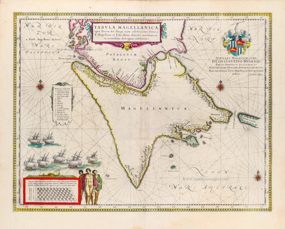
Tabula Magellanica, qua Tierrae del fuego, cum celeberrimis fretis a F. Magellano et I. Le Maire detectis novissima et accuratissima descriptio exhibetur. 1645
Straits of Magellan, by Willem & Joan Blaeu.
[Item number: 31602]

Early map which includes Straits Lemaire. First edition
Freti Magellanici ac Novi Freti vulgo Le Maire exactissima delineatio. 1630
Straits of Magellan, by Joannes Janssonius.
[Item number: 32424]

Scarce
FRETUM MAGELLANNICUM und dessen eigentüche Beschreibung, so die Hollender durchfuhren und auch der lang beschrieben. 1631
Strait of Magellan by Matthäus Merian, published by J.L. Gottfried.
[Item number: 32439]