
One of the most elaborately engraved maps ever published.
Pacific by Zacharias Châtelain after Nicolas de Fer. 1719

One of the most elaborately engraved maps ever published includes Southeast Asia with the north coast of Australia, America occupying a central position with California prominent as an island, to the west coast of Europe and Africa. The many inset plans, views, portraits, and scenes make this a visual encyclopaedia of the discovery and exploration of the Americas.
Large vignette of Niagara Falls; others show the hunting and drying of cod. Many historical notes and explorer's tracks.
Based partly on the De Fer map of 1713, it is interesting to show some of the missions established in Southern California, marking S. Jacques, S. Innocents, S. Etienne, S. Leon, Bonnenuit, S. Juan, S. Bruno and Gigante. It also keeps the Bay of S. Simon & S. Jude.
The Châtelain Family
Zacharias Châtelain (1684-1743) was a bookseller and publisher of Amsterdam. He was succeeded by his sons Zacharias jr and Henry Abraham. The Châtelain family was best known for the historical atlas Atlas Historique, ou nouvelle introduction à l’histoire…, a major work of its time. It was an encyclopaedia in seven volumes, including geography as one of its main subjects. The atlas was published in Amsterdam in seven volumes in various editions with different imprints from 1705 to 1739. An anonym person (Mr. C***) compiled the work with compositions of text, maps, plates and chronological and genealogical tables by Gueudeville, except volume 7, where H.P. Limiers took over this task. The maps were made mainly after the work of Guillaume de l'Isle.
The 1705 edition was published with the imprint “L’Honoré & Châtelain”. Later editions had the imprint: “les Frères Châtelain Libraires” or “L’Honoré & Châtelain Libraires”.
Carte tres Curieuse de la Mer du Sud, Contenant des Remarques Nouvelles et tres Utiles non Seulement sur les Ports et Iles de cette Mer,
Item Number: 29466 Authenticity Guarantee
Category: Antique maps > America > The Americas
Antique map of the Western Hemisphere showing the Pacific, the Americas and the Atlantic Ocean, with opposite the continental regions, by Zacharias Châtelain.
Title: Carte tres Curieuse de la Mer du Sud, Contenant des Remarques Nouvelles et tres Utiles non Seulement sur les Ports et Iles de cette Mer,
Mais aussy sur les principaux Pays de l'Amérique tant Septentrionale que Méridionale, Avec les Noms & la Route des Voyageurs par qui la découverte en a été faite.
Le tout pour l'intelligence Des dissertations suivantes.
Cartographer: Nicolas de Fer.
Date of the first edition: 1719.
Date of this map: 1719.
Copper engraving, printed on paper.
Size (not including margins): 810 x 1400mm (31.89 x 55.12 inches).
Verso: Blank.
Condition: Four sheets, joined as two, upper margin of top sheet extended as right, folds as issued.
Condition Rating: A.
From: Châtelain Z. Atlas Historique, ou Nouvelle Introduction A l'Histoire, à la Chronologie & à la Geographie Ancienne & Moderne; ... Tome VI. Qui comprend l'Afrique & l'Amerique Septentrionale & Meridionale, ... A Amsterdam, Chez L'Honoré & Châtelain Libraires, M.DCC.XIX. (1719). (Koeman II, p. 37, Cha7)
One of the most elaborately engraved maps ever published includes Southeast Asia with the north coast of Australia, America occupying a central position with California prominent as an island, to the west coast of Europe and Africa. The many inset plans, views, portraits, and scenes make this a visual encyclopaedia of the discovery and exploration of the Americas.
Large vignette of Niagara Falls; others show the hunting and drying of cod. Many historical notes and explorer's tracks.
Based partly on the De Fer map of 1713, it is interesting to show some of the missions established in Southern California, marking S. Jacques, S. Innocents, S. Etienne, S. Leon, Bonnenuit, S. Juan, S. Bruno and Gigante. It also keeps the Bay of S. Simon & S. Jude.
The Châtelain Family
Zacharias Châtelain (1684-1743) was a bookseller and publisher of Amsterdam. He was succeeded by his sons Zacharias jr and Henry Abraham. The Châtelain family was best known for the historical atlas Atlas Historique, ou nouvelle introduction à l’histoire…, a major work of its time. It was an encyclopaedia in seven volumes, including geography as one of its main subjects. The atlas was published in Amsterdam in seven volumes in various editions with different imprints from 1705 to 1739. An anonym person (Mr. C***) compiled the work with compositions of text, maps, plates and chronological and genealogical tables by Gueudeville, except volume 7, where H.P. Limiers took over this task. The maps were made mainly after the work of Guillaume de l'Isle.
The 1705 edition was published with the imprint “L’Honoré & Châtelain”. Later editions had the imprint: “les Frères Châtelain Libraires” or “L’Honoré & Châtelain Libraires”.
Related items

America sive India Nova ad magnae Gerardi Mercatoris avi Universalis imitationem in compendium redacta. 1623
America, by Gerard Mercator
[Item number: 131]

Americae nova Tabula. 1647-49
America, by Willem Blaeu.
[Item number: 6717]

Nieuwe Kaart van America c. 1770
Antique map of America by Tirion I.
[Item number: 19194]

America. 1597
AMERICA by Giovanni Magini
[Item number: 22492]

America sive India Nova, ad magnae Gerardi Mercatoris avu Universalis imitationem, in compendium redacta. 1623
America, by Gerard Mercator.
[Item number: 27752]

Original Halma edition.
L'Amerique selon les Nouvelles Observations de Messrs. de l'Academie des Sciences, etc. Before 1713
America, by François Halma.
[Item number: 28017]

Novissima et Accuratissima Totius Americae Descriptio. 1656-77
America by Nicolaes Visscher I.
[Item number: 28554]

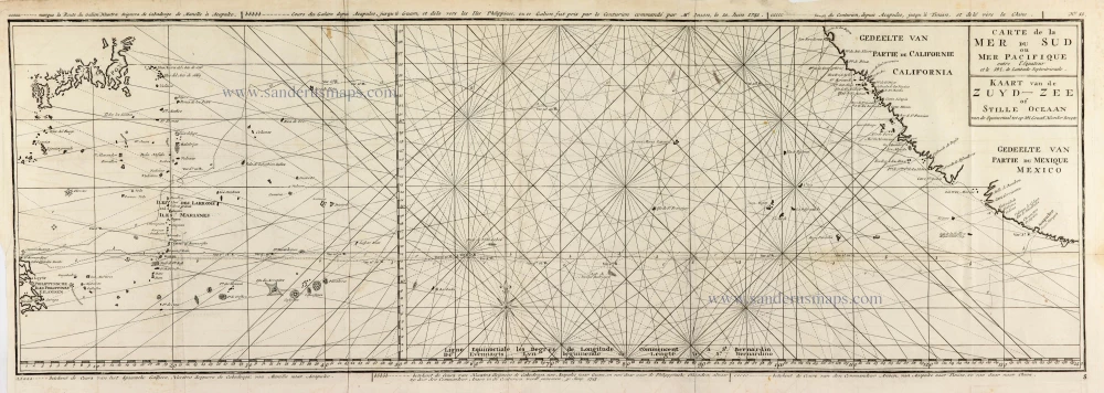
Carte de la Mer du Sud ou Mer Pacifique. Entre l'Equateur et le 39.5 de Latitude septentrion.le. 1748
Map of the southern Pacific, showing a part of the path of George Anson's voyage around the world.
[Item number: 30330]
Carte de la Mer du Sud ou Mer Pacifique entre l'Equateur et le 39.5 de Latitude Septentrionale. - Kaart van de Zuyd-Zee of Stille Oceaan ... 1751
Map of the southern Pacific, showing a part of the path of George Anson's voyage around the world.
[Item number: 30609]
Early map of the North Atlantic
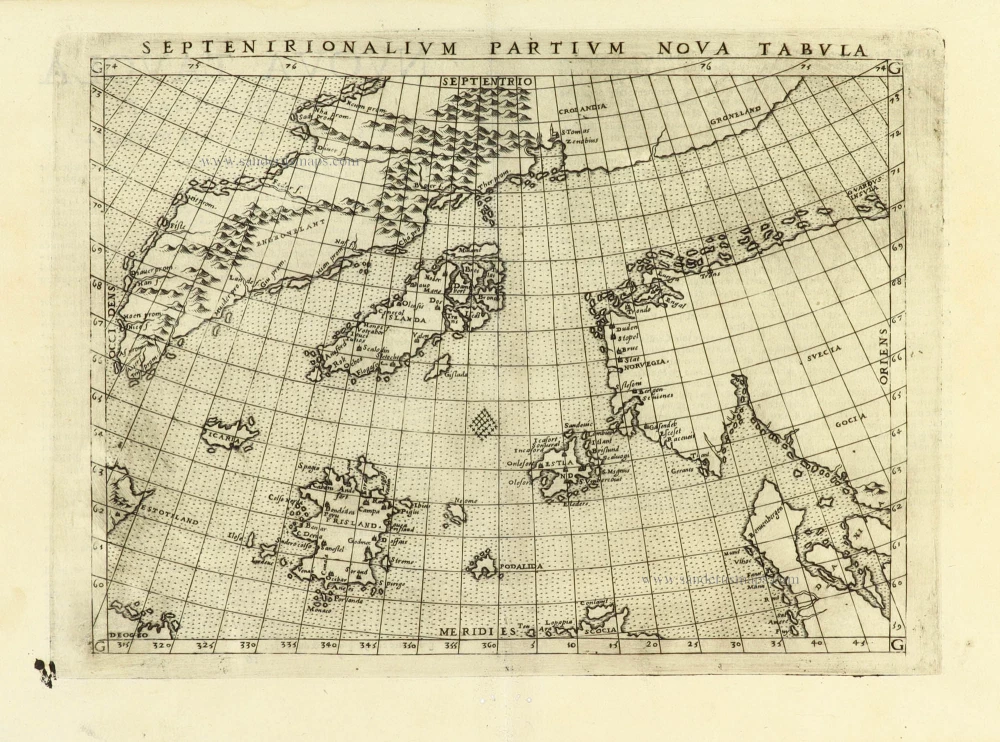
Septenirionalium Partium Nova Tabula. 1574
Northern Atlantic Ocean by Girolamo Ruscelli.
[Item number: 32185]

Rare and interesting map
Scheeps-Togt door Ferdinand Magellaan uit Kastilien gedaan na R. de la Plata en van daar door zyn ontdekte straat tot aan de Moluccas. 1707
Voyage of Magellan from Spain to Asia, by Pieter Van der Aa.
[Item number: 32347]

Important map
Maris Pacifici, (quod vulgo Mar del Zur) cum regionibus circumiacentibus, insulisque in codem passim sparsis, novissima descriptio. 1603
Pacific Ocean by Abraham Ortelius.
[Item number: 33069]
new