
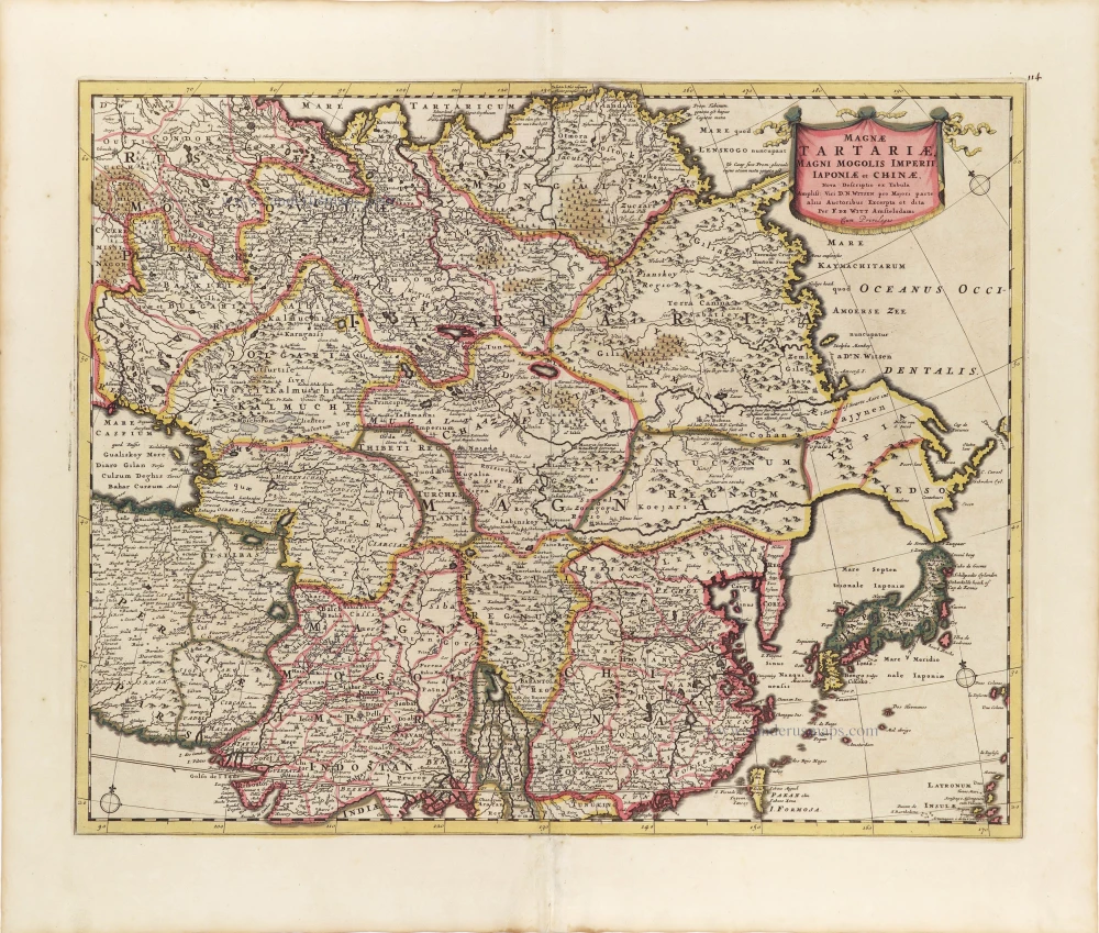
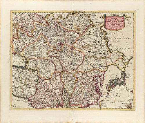
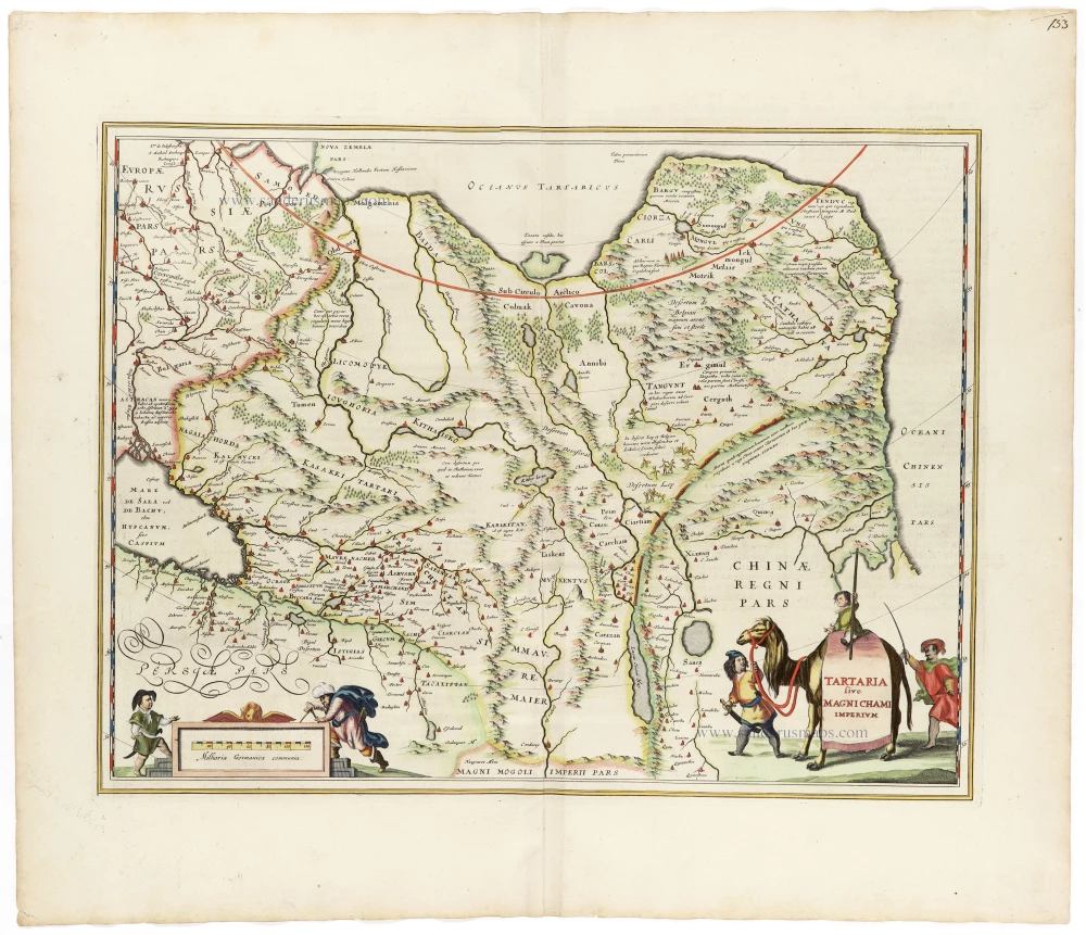
Tartary, China, and Japan, by Frederick de Wit. ca. 1697-1707
Frederick de Wit (1630-1706)
The engraver and map-seller, Frederick de Wit, was born in Gouda (Netherlands) in 1630 as a son of Hendrick Fredericksz de Wit. Through his marriage with Maria van der Waag of Amsterdam in 1661, he obtained citizenship of the city where he had been working since 1648 and where he became one of the most famous engravers of maps of the second half of the 17th century. Although De Wit was a Catholic, which meant that he was not favoured at the time by the city council, he was awarded the honour of being listed as one of the "excellent citizens" on the roll of the city council in the years 1694-1704. However, his name was not written in the Guild of St. Luke book before 1664. At that time, he lived on the Kalverstraat "in de Witte Pascaert", where he stayed until his death in 1706. His earliest dates on maps engraved are 1659 (Regni Daniae) and 1660 (World map).
Frederick de Wit published several world atlases, a sea atlas, and an atlas of the Netherlands.
The dating of the maps is difficult. However, as a privilege was granted in 1689, the annotation 'cum privilegio' marks an edition after 1688.
Around 1700, Frederick de Wit entered the market with a town atlas. He produced two volumes with a total of 260 plans and views. Most were printed from plates used for Janssonius and Blaeu town atlases.
After he died in 1706, his widow continued the shop until 1709. The plates and stock of De Wit's atlas were sold to Covens & Mortier in 1710, who sold the atlas for an extended period.
Magnae Tartariae, Magni Mogolis Imperii, Iaponiae et Chinae.
Item Number: 28996 Authenticity Guarantee
Category: Antique maps > Asia > Central Asia
Old, antique map of Tartariae, by Frederick de Wit.
Title: Magnae Tartariae, Magni Mogolis Imperii, Iaponiae et Chinae.
Nova Descriptio ex Tabula Ampliss. Viri D.N. Witsen pro Majori parte aliis Auctoribus Excerpta et dita
Per F. De Witt Amstelodami
Cum Privilegio.
Date: ca. 1697-1707.
Copper engraving, printed on paper.
Map size: 435 x 555mm (17.13 x 21.85 inches).
Sheet size: 540 x 630mm (21.26 x 24.8 inches).
Verso: Blank.
Condition: Original coloured, excellent.
Condition Rating: A+.
From: Atlas. Amsterdam, Frederick de Wit, after 1705. (Koeman, III p. 202, Wit16; Carhart p. 159 A157)
Frederick de Wit (1630-1706)
The engraver and map-seller, Frederick de Wit, was born in Gouda (Netherlands) in 1630 as a son of Hendrick Fredericksz de Wit. Through his marriage with Maria van der Waag of Amsterdam in 1661, he obtained citizenship of the city where he had been working since 1648 and where he became one of the most famous engravers of maps of the second half of the 17th century. Although De Wit was a Catholic, which meant that he was not favoured at the time by the city council, he was awarded the honour of being listed as one of the "excellent citizens" on the roll of the city council in the years 1694-1704. However, his name was not written in the Guild of St. Luke book before 1664. At that time, he lived on the Kalverstraat "in de Witte Pascaert", where he stayed until his death in 1706. His earliest dates on maps engraved are 1659 (Regni Daniae) and 1660 (World map).
Frederick de Wit published several world atlases, a sea atlas, and an atlas of the Netherlands.
The dating of the maps is difficult. However, as a privilege was granted in 1689, the annotation 'cum privilegio' marks an edition after 1688.
Around 1700, Frederick de Wit entered the market with a town atlas. He produced two volumes with a total of 260 plans and views. Most were printed from plates used for Janssonius and Blaeu town atlases.
After he died in 1706, his widow continued the shop until 1709. The plates and stock of De Wit's atlas were sold to Covens & Mortier in 1710, who sold the atlas for an extended period.
Related items
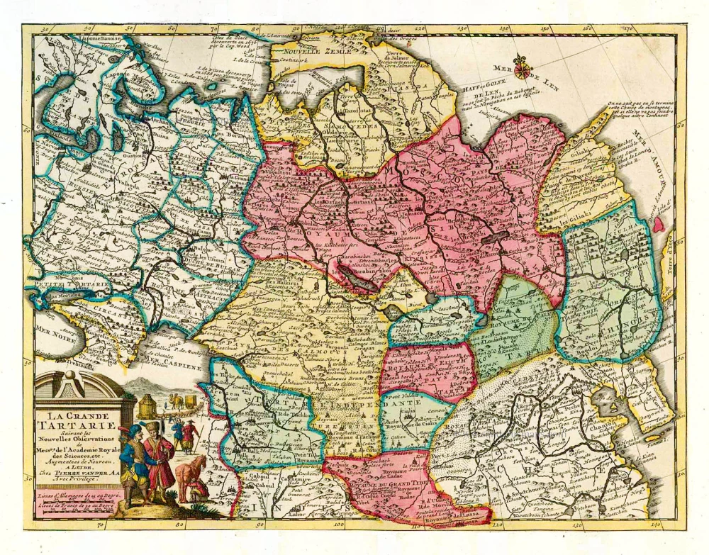
La Grande Tartarie. 1713
Tartary, by Pieter van der Aa.
[Item number: 26112]

Title on verso: Tabula .VIII. Asiae. 1525
Central Asia - Tartary, by Lorenz Fries.
[Item number: 27994]

Tartariae Sive Magni Chami Regni Typus. 1584
Tartary, by Abraham Ortelius.
[Item number: 29224]

Tartaria sive Magni Chami Imperium. 1643
Tartary, by Willem & Joan Blaeu.
[Item number: 30142]

Royaume de la Chine. 1682
China by Nicolas Sanson, published by Simon de Vries.
[Item number: 30235]

Important and rare China map.
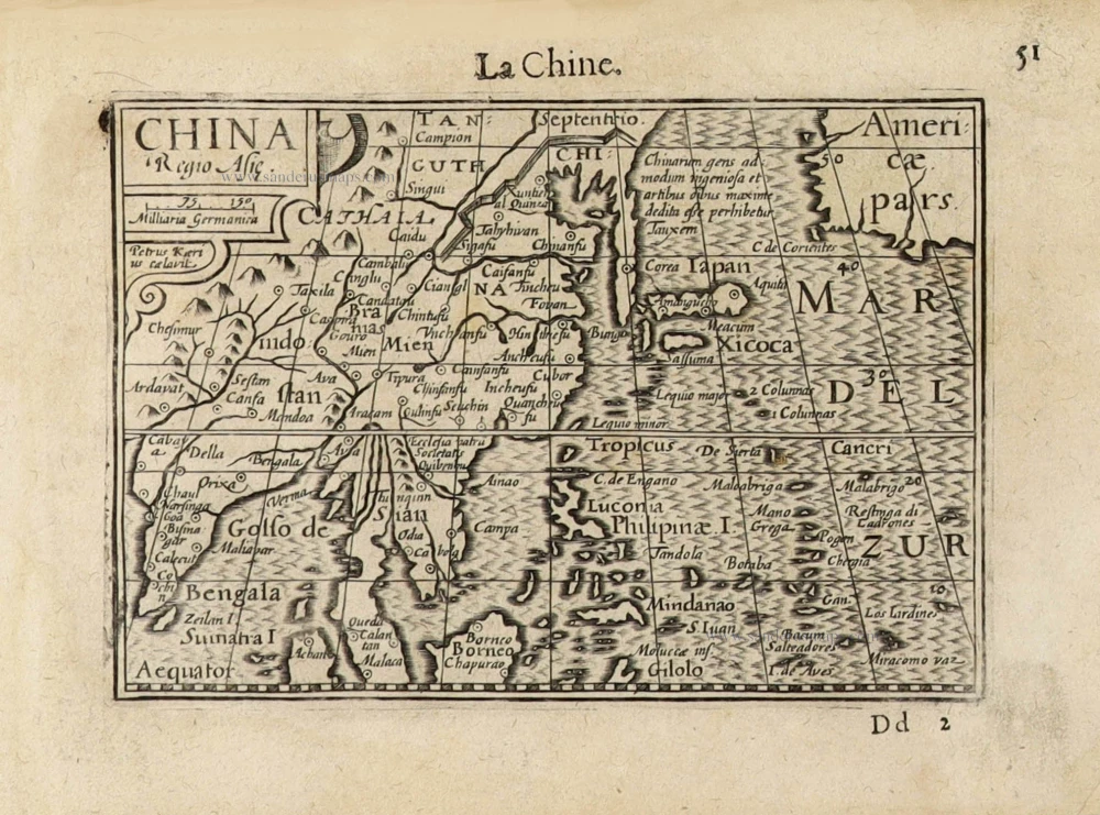
China Regnum. 1593
China by Cornelis de Jode
[Item number: 30312]
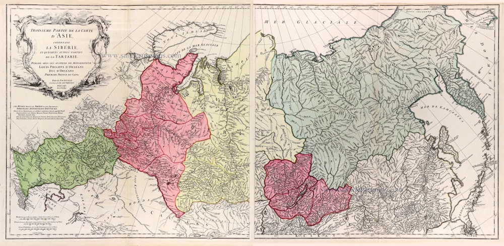
Troisieme partie de la carte d'Asie, contenant la Siberie, et quelques autres parties de la Tartarie. 1753
Siberia & Tartary by J.B. d'Anville, published by N. de Fer.
[Item number: 31077]
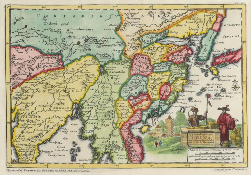
't Koninkryk van China, met d'aangrensende Landen van Siam en Bengale. 1706
China by Pieter Van der Aa.
[Item number: 31842]

Chinae, Olim Sinarum regionis, nova descriptio. 1584
China by Abraham Ortelius.
[Item number: 32005]

Tartaria. 1618
Tartary by Petrus Bertius, published by Jodocus Hondius II
[Item number: 32138]

China. 1618
China by Petrus Bertius, published by Jodocus Hondius II.
[Item number: 32151]
China Regio Asiae. c. 1600
China by Barent Langenes.
[Item number: 32299]

Vue et Description de la Ville de Meaco, Capitale du Japon avec d'autres Particularitez du Pays. 1719
Kyoto - Decima (Japan), by Z. Châtelain.
[Item number: 32303]
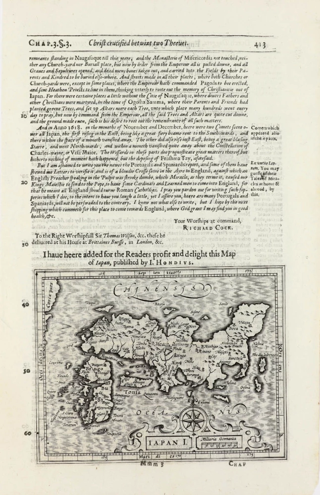
Iapan I. 1625
Japan by Jodocus Hondius, published by Samuel Purchas
[Item number: 32418]
Tartaria Sive Magnichami Imperium 1666
Tartary, by Johannes Janssonius.
[Item number: 33095]
new