
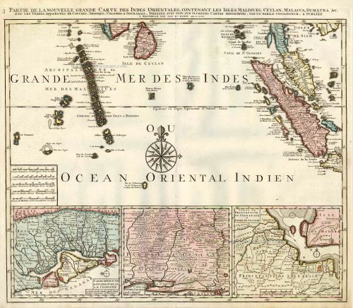
Indian Ocean (North), by J.B. Elwe. 1792

Jan Barend Elwe (florished 1785-1809)
The Amsterdam bookseller and publisher, J.B. Elwe, was probably of foreign origin. His activities in the book trade date back to 1785, a date found on an atlas.
Partie de la Nouvelle Grande Carte des Indes Orientales, Contenant les Isles Maldives, Ceylan, Malacca, Sumatra &c.
Item Number: 2363 Authenticity Guarantee
Category: Antique maps > Asia > India - Ceylon
Old, antique map of the Northern Ondian Ocean with Malaysia, Sumatra,the Maldives and Ceylon, by J.B. Elwe.
With 3 insets: Carte de Royaume de Couchin de Coilan et de Cranganor; Carte de Nigomob, Colombo; Carte de Princepaute de Soerabaye et Terre de Grissik.
Date of the first edition: 1792
Date of this map: 1792
Copper engraving, printed on paper.
Size (not including margins): 52.5 x 61cm (20.5 x 23.8 inches)
Verso: Blank
Condition: Original coloured, excellent.
Condition Rating: A+
References: Koeman, II El2 (29).
From: Atlas. Amsterdam, J.B. Elwe, 1792. (Koeman, II, El2)
This is the third map of Elwe's Southeast Asia in four sheets, made after R. & J. Ottens.
Jan Barend Elwe (florished 1785-1809)
The Amsterdam bookseller and publisher, J.B. Elwe, was probably of foreign origin. His activities in the book trade date back to 1785, a date found on an atlas.
Related items
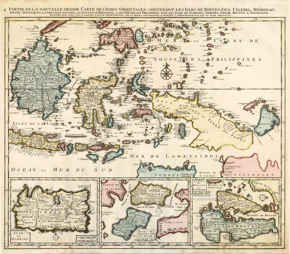
Partie de la Nouvelle Grande Carte des Indes Orientales, Contenant les Isles de Borneo, Iava, Celebes, Mindanao ... 1792
Indonesia - New Guinea - Australia by J.B. Elwe.
[Item number: 2293]

Archipel des Indes Orientales qui Comprend les Isles de la Sonde, Moluques et Philippines. c. 1757
Southeast Asia, par Robert de Vaugondy.
[Item number: 4751]

From the Cloppenburg edition
Insulae Indiae Orientalis. 1630
Southeast Asia, by G. Mercator - J. Hondius.
[Item number: 25234]
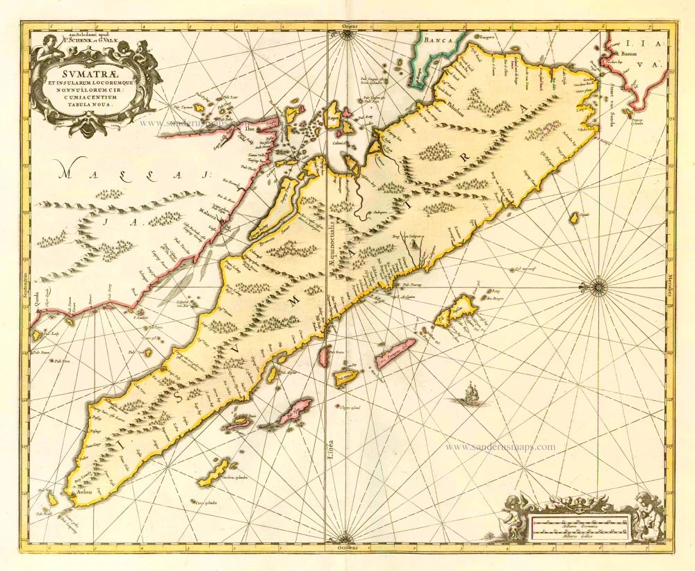
Sumatrae et Insularum Locorumque Nonnullorum Circumiacentium Tabula Nova. c. 1700
Sumatra, by G. Valk & P. Schenk.
[Item number: 25714]

Le Royaume de Siam avec les Royaumes qui luy sont Tributaires, et les Isles de Sumatra, Andemaon, etc. et les Isles Voisine. c. 1700
Southeast Asia, by J. Ottens.
[Item number: 25716]

Indiae Orientalis nec non Insularum Adiacentium Nova Descriptio. c. 1740
Southeast Asia by Nicolaes Visscher, published by Petrus Schenk.
[Item number: 25718]

Sinus Gangeticus Vulgo Golfo de Bengala Nova Descriptio. c. 1700
Gulf of Bengal, by G. Valk & P. Schenk.
[Item number: 25835]

Magni Mogolis Imperium. After 1721
Mongol Empire, by Frederick de Wit - Covens & Mortier.
[Item number: 25838]

Carte du Golfe de Bengale, Mer des Indes, et Riviere du Gange, Avec les Païs et Iles d'alentour, Savoir les Côtes de Malabar, Cormandel, Ile de Ceylon, les Maldives, les Rolaumes de Visiapour, Golconda, Guzaratte, etc. 1713
India and Ceylon (Sri Lanka), by Pieter van der Aa.
[Item number: 26095]
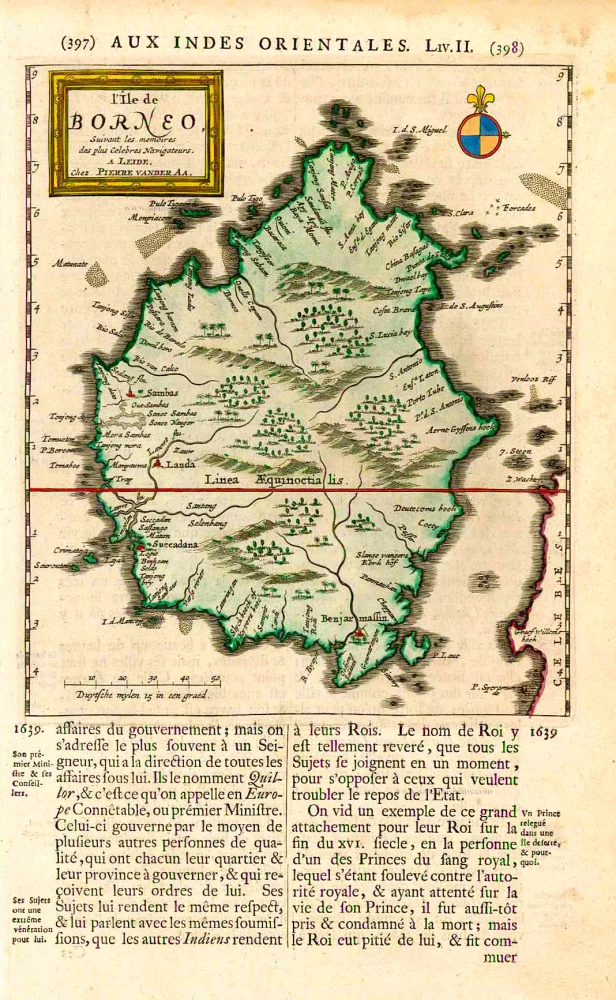
L'Île de Borneo. 1719
Borneo, by Pieter Van der Aa.
[Item number: 26419]

Scarce
Basora En de Landschappen Tussen den Eufrat en Tiger stroom, een Gedeelte van Persien, de Indiaanze Zee en Kusten, tot aan de Straat Zunda. 1714
Indian Ocean by Pieter Vander Aa
[Item number: 31082]

First folio sea chart from the Dutch Golden Age
Mar di India. 1650
Indian Ocean by J. Janssonius
[Item number: 32184]

Scarce
Zee-togt van Alfonso d'Albuquerque na de Roode Zee, d'Arabize en Persize kusten, met die van Ormus, Guzaratte, Goa, Malacca en Verder Indien tot aan't Eiland Iava. 1707
Indian Ocean & Southeast Asia by Pieter Van der Aa.
[Item number: 32321]

Scarce
De Kusten van Guzaratte, Malabar, Bengale en Malacca met die van't Magtig Koninkryk Siam, tot aan China bestevend. 1707
Indian Ocean, India, Thailand, and Siam by Pieter Van der Aa.
[Item number: 32323]

An extremely decorative sea chart (Norwhich)
Nieuwe Pascaert van Oost Indien Verthoonende hen van C. De Bona Esperanca tot aen het Landt van Eso. 1683
Indian Ocean - Southeast Asia - Australia by Johannes Van Keulen
[Item number: 33150]
new