
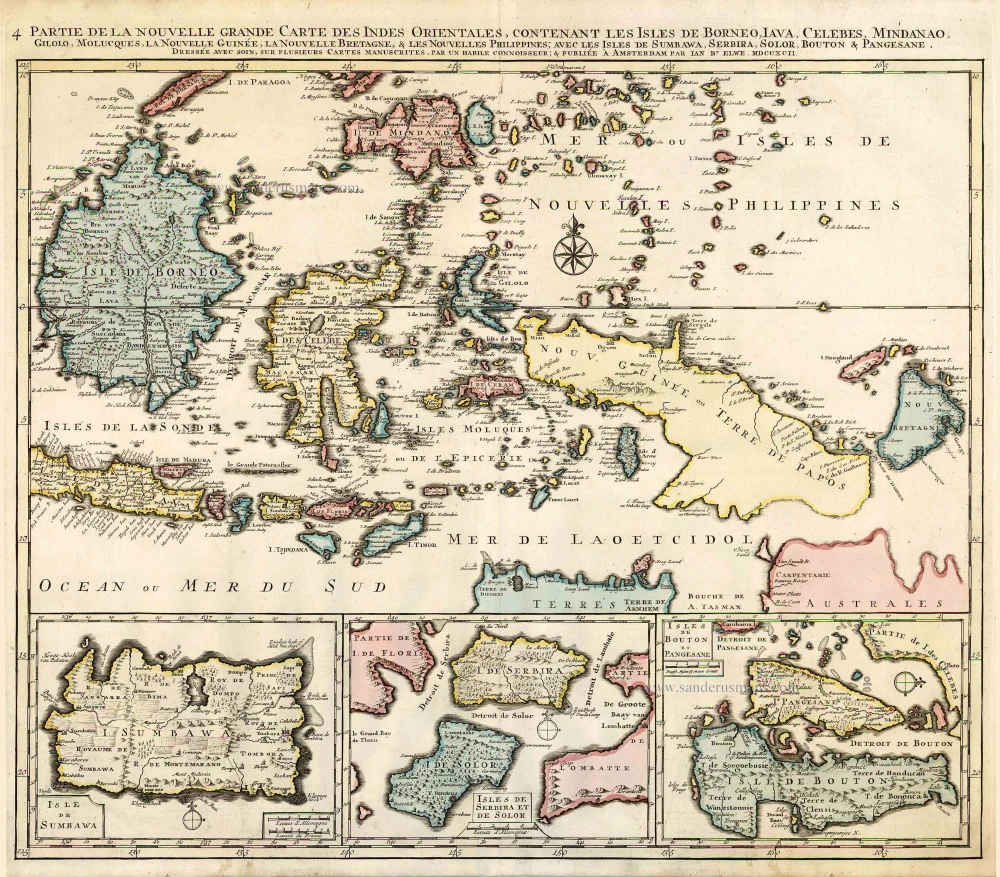
Indonesia - New Guinea - Australia by J.B. Elwe. 1792


Jan Barend Elwe (florished 1785-1809)
The Amsterdam bookseller and publisher, J.B. Elwe, was probably of foreign origin. His activities in the book trade date back to 1785, a date found on an atlas.
Partie de la Nouvelle Grande Carte des Indes Orientales, Contenant les Isles de Borneo, Iava, Celebes, Mindanao ...
Item Number: 2293 Authenticity Guarantee
Category: Antique maps > Asia > Southeast Asia
Old, antique map of Southeast Asia with Indonesia, New Guinea and Northern Australia, by J.B. Elwe.
With insets of Sumbawa; Serbira; Solor, Bouton and Pangesane.
Date of the first edition: 1792
Date of this map: 1792
Copper engraving, printed on paper.
Size (not including margins): 52.5 x 61cm (20.5 x 23.8 inches)
Verso: Blank
Condition: Original coloured, excellent.
Condition Rating: A+
References: Koeman, II El2 (30).
From: Atlas. Amsterdam, J.B. Elwe, 1792. (Koeman, II, El2)
This is the 4th map of Elwe's Southeast Asia in four sheets, made after R. & J. Ottens.
Jan Barend Elwe (florished 1785-1809)
The Amsterdam bookseller and publisher, J.B. Elwe, was probably of foreign origin. His activities in the book trade date back to 1785, a date found on an atlas.
Related items

Partie de la Nouvelle Grande Carte des Indes Orientales, Contenant les Isles Maldives, Ceylan, Malacca, Sumatra &c. 1792
Indian Ocean (North), by J.B. Elwe.
[Item number: 2363]

Archipel des Indes Orientales qui Comprend les Isles de la Sonde, Moluques et Philippines. c. 1757
Southeast Asia, par Robert de Vaugondy.
[Item number: 4751]

The most accurate and one of the most elegant 17th c. maps of the East Indies
Indiae Orientalis Nova Descriptio. 1644-58
Southeast Asia by Janssonius, Johannes
[Item number: 10013]

From the Cloppenburg edition
Insulae Indiae Orientalis. 1630
Southeast Asia, by G. Mercator - J. Hondius.
[Item number: 25234]

Caarte van Nova Guinea, Nieulijck inden iare 1616 bezeijlt, ende beschreven door Willem Schouten van Hoorn. 1618
New Guinea, by W.C. Schouten
[Item number: 25400]
Sumatrae et Insularum Locorumque Nonnullorum Circumiacentium Tabula Nova. c. 1700
Sumatra, by G. Valk & P. Schenk.
[Item number: 25714]

Le Royaume de Siam avec les Royaumes qui luy sont Tributaires, et les Isles de Sumatra, Andemaon, etc. et les Isles Voisine. c. 1700
Southeast Asia, by J. Ottens.
[Item number: 25716]

Indiae Orientalis nec non Insularum Adiacentium Nova Descriptio. c. 1740
Southeast Asia by Nicolaes Visscher, published by Petrus Schenk.
[Item number: 25718]
L'Inde de la le Gange, 1713
Southeast Asia, by Pieter van der Aa.
[Item number: 26097]

L'Île de Sumatra. 1713
Sumatra by P. Van der Aa
[Item number: 26126]
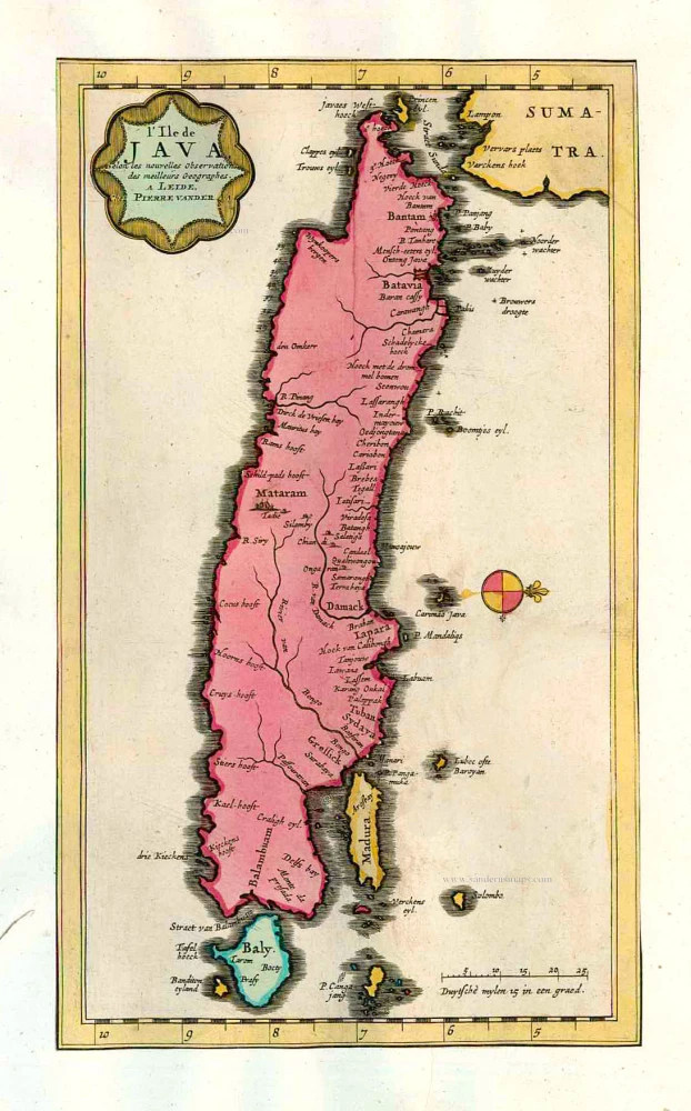
L'Ile de Java. 1713
Java, by Pieter van der Aa.
[Item number: 26127]

Anthony van Diemens Land | Het vaste Landt bezuyden den Klippigen hoek. | Het Staten Landt bezuyden den Klippigen hoek. 1726
Map and views of Tasmania, by François Valentyn.
[Item number: 27921]

Staeten Landt Bezylt en Ontdekt met de Scheepen Heemskerk en de Zeehaen onder het Commande van den E. Abel Tasman. In den Iaare 1642. Den 13 December.. 1726
New Zealand, by François Valentyn.
[Item number: 27922]

Nuova Guinea. 1696
Globe gore with Northern Australia and the East Indies, by V.M. Coronelli.
[Item number: 30785]

Important map with Tasman's first voyage
Kaart der Reyse van Abel Tasman Volgens syn eygen Opstel. 1726
Valentyn François, Australia
[Item number: 31086]
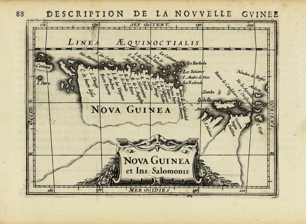
Nova Guinea et Ins. Salomonis. 1618
New Guinea by Petrus Bertius, published by Jodocus Hondius II.
[Item number: 31528]
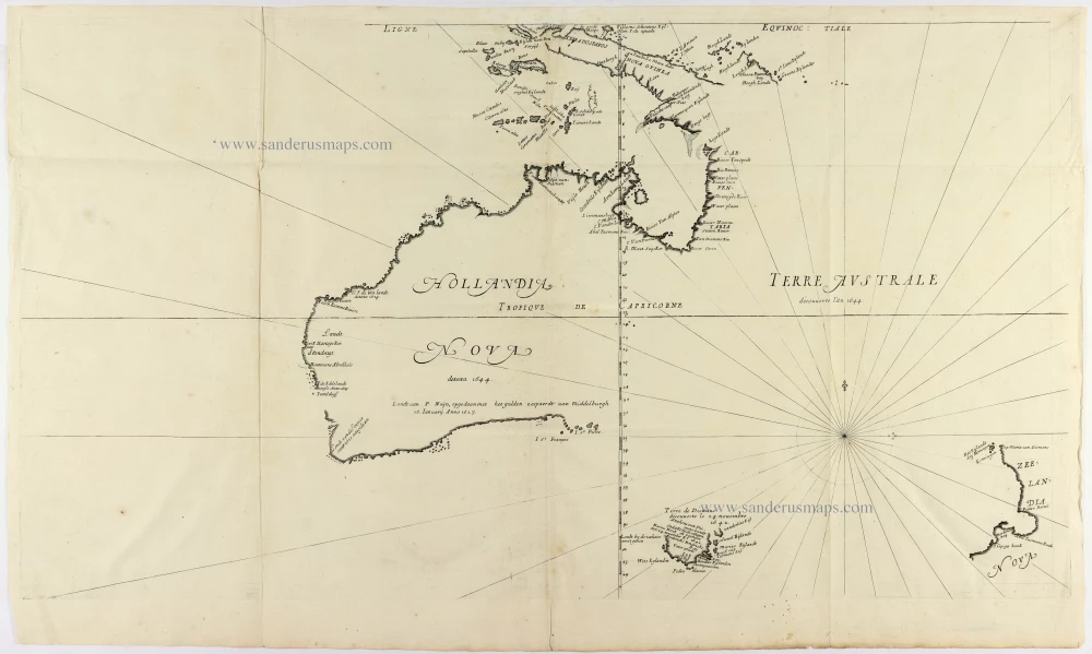
Cornerstone map of Australia
Hollandia Nova detecta 1644. - Terre Australe decouuerte l'an 1644. 1663-72.
Thevenot Melchisedech, Australia
[Item number: 31818]

A Rare Pre-Cook Map Focusing on Australia
Carte Réduite des Terres Australes. 1758
Australia by Jacques-Nicolas Bellin, published by A.F. Prévost.
[Item number: 31885]

Rare
[No title] 1608
Spice Islands by Hulsius Levinus.
[Item number: 32054]
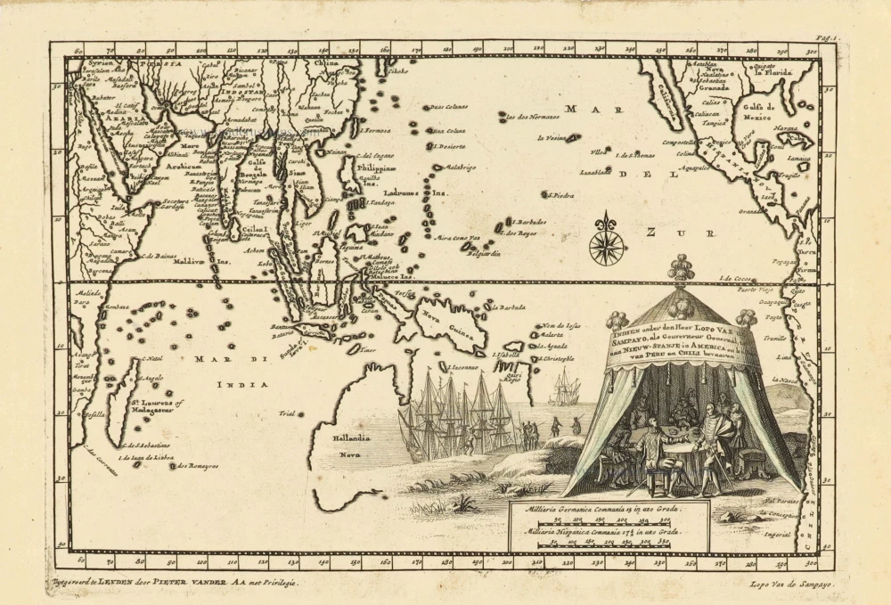
Indien onder den Heer Lopo Vaz de Sampayo, als Gouverneur Generaal tot aan Nieuw-Spanje in Amrica en kusten van Peru en Chili bevaaren. 1707
Southeast Asia and Australia, by Pieter Van der Aa.
[Item number: 32359]

An extremely decorative sea chart (Norwhich)
Nieuwe Pascaert van Oost Indien Verthoonende hen van C. De Bona Esperanca tot aen het Landt van Eso. 1683
Indian Ocean - Southeast Asia - Australia by Johannes Van Keulen
[Item number: 33150]
new