
Old antique map of Philippines by Malaspina Alessandro 1808

In 1784 Chretien Louis Joseph de Guignes traveled to China as Resident of France in China and consul at Canton. From 1794-95, de Guignes served as an interpreter while traveling through eastern China with Isaac Titsingh, the Dutch ambassador to the court of the Qianlong Emperor of China. Heading to Beijing to celebrate the sixtieth anniversary of the Qianlong Emperor's reign, Titsingh and his colleagues conformed to the demands of the Chinese court etiquette and succeeded in developing good relations with China. De Guignes and the members of the Titsingh mission were the last European diplomats to appear before the Imperial court until after the Opium Wars of the next century. During his journey, de Guignes made observations on Chinese history, society and culture, geography, economics, and manufacturing. Upon returning to France in 1801, de Guignes published an account of his 17 years of travels through China, the Philippines, and Mauritius in Voyages a Peking, Manille et l'Ile de France, faits dans l'intervalle des annees 1784 a 1801. The following two maps were included in de Guignes' account and engraved by D'Houdan:
Carte des Iles Philippines. A simple map of the Philippines that extends to Borneo in the south. It shows Guignes' route through the central Philippines and notes several banks to the west of Manilla. Marked sheet No. 96 at top right.
Baie de Manille par M. de Malespina. This crisp chart presents Manilla Bay along with the city of Manilla. A number of soundings, anchorages, and islands are shown in the waters with a few place names identified along the coastline. Marked sheet No. 97 at top right.
Carte des Îles Philippines. - Baie de Manille par M. de Malespina.
Item Number: 26943 Authenticity Guarantee
Category: Antique maps > Asia > Southeast Asia
Two old maps of the Philippines, by Alessandro Malaspina.
Date of the first edition: 1808
Date of this map: 1808
Steel engravings, engraved by Dhoudan.
Size (not including margins): 26 x 19cm (10.1 x 7.4 inches) and 21 x 18.5cm (8.2 x 7.2 inches)
Verso: Blank
Condition: Excellent.
Condition Rating: A+
References: Quirino, p.74.
From: de Guignes C.L.J. Voyages à Péking, Manille et L'Île de France, faits dans l'intervalle des années 1784 à 1801. Paris, 1808.
In 1784 Chretien Louis Joseph de Guignes traveled to China as Resident of France in China and consul at Canton. From 1794-95, de Guignes served as an interpreter while traveling through eastern China with Isaac Titsingh, the Dutch ambassador to the court of the Qianlong Emperor of China. Heading to Beijing to celebrate the sixtieth anniversary of the Qianlong Emperor's reign, Titsingh and his colleagues conformed to the demands of the Chinese court etiquette and succeeded in developing good relations with China. De Guignes and the members of the Titsingh mission were the last European diplomats to appear before the Imperial court until after the Opium Wars of the next century. During his journey, de Guignes made observations on Chinese history, society and culture, geography, economics, and manufacturing. Upon returning to France in 1801, de Guignes published an account of his 17 years of travels through China, the Philippines, and Mauritius in Voyages a Peking, Manille et l'Ile de France, faits dans l'intervalle des annees 1784 a 1801. The following two maps were included in de Guignes' account and engraved by D'Houdan:
Carte des Iles Philippines. A simple map of the Philippines that extends to Borneo in the south. It shows Guignes' route through the central Philippines and notes several banks to the west of Manilla. Marked sheet No. 96 at top right.
Baie de Manille par M. de Malespina. This crisp chart presents Manilla Bay along with the city of Manilla. A number of soundings, anchorages, and islands are shown in the waters with a few place names identified along the coastline. Marked sheet No. 97 at top right.
Related items
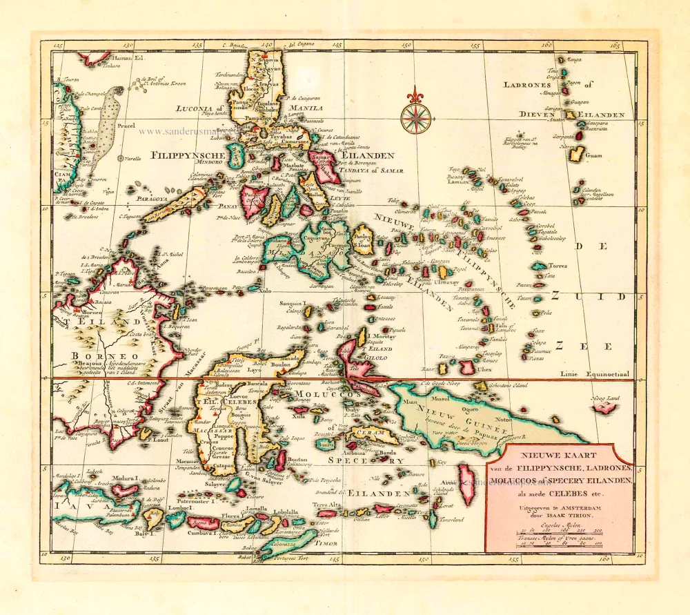
Nieuwe Kaart van de Filippynsche, Ladrones, Moluccos of Specery Eilanden als mede Celebes, etc. 1744
Philippines - Indonesia by Tirion I.
[Item number: 26584]
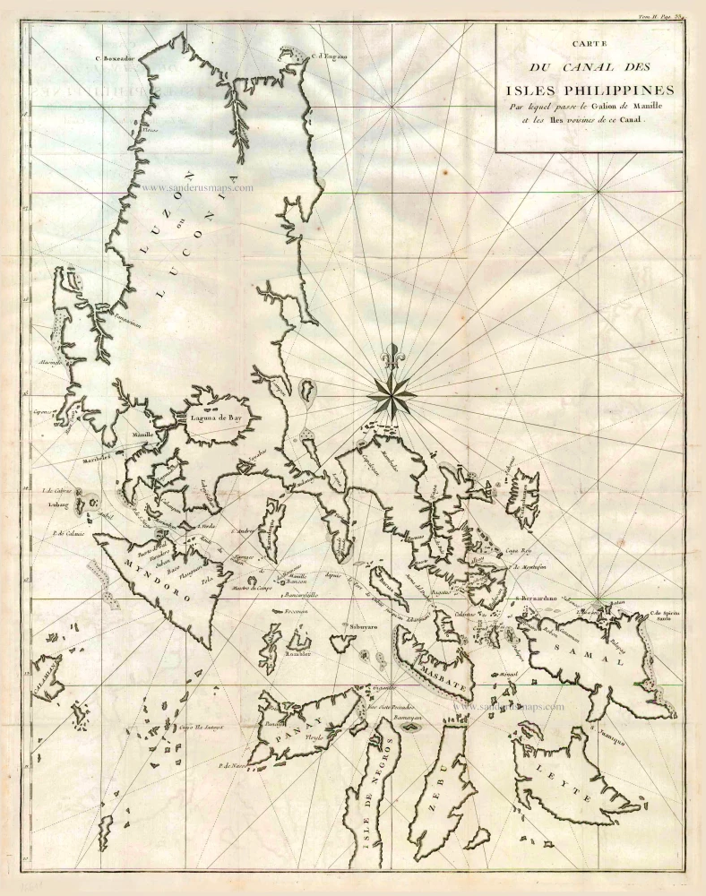
Carte du Canal des Iles Philippines par lequel Passe le Galion de Manille et les Iles Voisines de ce Canal. 1749
Philippines by Bonne Rigobert
[Item number: 26611]