
Southeast Asia by Waldseemüller Martin 1513
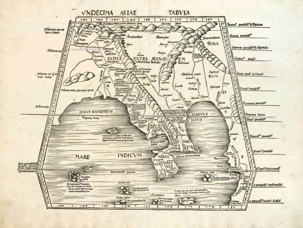
The Strassbourg Ptolemy is the most important edition of the Geographia. Preparatory work was begun in about 1505 by Martin Waldseemüller, scholar-geographer of the small town of St. Dié in Lorraine, together with his associate Mathias Ringmann. Waldseemüller is believed to have incised many of the maps himseld; all are firm distinctive woodcuts. By 1507 much progress had been made but the project was delayed and was not completed until 1513 under the editorship of Jacob Eszler and Georg Ubelin. The printer was Johann Schott, and the work, the first modern atlas, bears a dedication to the Emperor Maximilian.
Martin Waldseemüller (Ilacomilus) (c. 1473-1519)
Martin Walseemüller and his collaborator, Matthias Ringmann, are credited with the first recorded usage of the word America to name the New World in honour of the Italian explorer Amerigo Vespucci.
He was born about 1475, most probably in the village of Wolfenweiler near Freiburg in Breisgau (southern Germany). He studied at the University of Freiburg, where he met Johann Scott, the future printer of Waldseemüller’s edition of Ptolemy and Matthias Ringman, a poet who wrote Waldseemüller’s texts. Gregor Reisch was their tutor. He was noted for his philosophical work, Margaretha Philosophica (1503), a widely read book that included a world map in Ptolemaic form. He undoubtedly aroused the students’ interest in cosmography.
At the beginning of the 16th century, Walseemüller moved to St.Dié in the Vosges. He Hellenized his name to Ilacomilus and worked on an edition of Ptolemy. He learned the printing trade in Basle and became a professor of cosmography under the patronage of René II, Duke of Lorraine.
Together with a group of scholars, among them were Nicholas Lud and Matthias Ringmann, they installed a printing press in St. Dié. The first book appeared in 1507: Cosmographiae Introductio… Few books have generated as much interest and speculation as this book because it suggested that the new continent is named America in honour of Amerigo Vespucci, whose letters about his American “discoveries” form a large part of the book. Great interest was also attached to the two maps on the title page constituting part of the Cosmographiae Introductio: a large 12-panel wall map of the world and a set of globe gores. The map and globe were notable for showing the New World as a continent separate from Asia and naming the southern landmass America.
Ringmann wrote the Cosmographiae Introductio's text, using the name ‘America’. He died in 1511, and by then, Waldseemüller was having doubts about the name they had coined.
In 1511, Walseemüller published the Carta Itineraria Europae, a road map of Europe that showed essential trade routes and pilgrim routes from central Europe to Santiago de Compostela, Spain. It was the first printed wall map of Europe.
After Ringmann’s death, Waldseemüller concentrated on the new version of Ptolemy’s Geographia. The new edition was finally printed in 1513 by Johannes Scott in Strasbourg and is now regarded as the most important. Waldseemüller included twenty modern maps in the new Geographia as a separate appendix.
The 1507 wall map was lost for a long time, but Joseph Fischer found a copy in Schloss Wolfegg in southern Germany in 1901. It is the only known copy purchased by the United States Library of Congress in May 2003.
Undecima Asiae Tabula
Item Number: 11993 Authenticity Guarantee
Category: Antique maps > Asia > Southeast Asia
Old, antique map of Southeast Asia by Martin Waldseemüller
Date of the first edition: 1513
Date of this map: 1513
Woodcut
Size, not including title and marginalia: 38 x 44cm (14.8 x 17.2 inches)
Verso: Blank
Condition: Excellent.
Condition Rating: A
References: Karrow, 80/30.
From: Claudii Ptolemei viri Alexandrini Mathematice discipline Philosophi dictissimi Geographiae opus novissima . . . Strassburg, J. Schott, 1513.
The Strassbourg Ptolemy is the most important edition of the Geographia. Preparatory work was begun in about 1505 by Martin Waldseemüller, scholar-geographer of the small town of St. Dié in Lorraine, together with his associate Mathias Ringmann. Waldseemüller is believed to have incised many of the maps himseld; all are firm distinctive woodcuts. By 1507 much progress had been made but the project was delayed and was not completed until 1513 under the editorship of Jacob Eszler and Georg Ubelin. The printer was Johann Schott, and the work, the first modern atlas, bears a dedication to the Emperor Maximilian.
Martin Waldseemüller (Ilacomilus) (c. 1473-1519)
Martin Walseemüller and his collaborator, Matthias Ringmann, are credited with the first recorded usage of the word America to name the New World in honour of the Italian explorer Amerigo Vespucci.
He was born about 1475, most probably in the village of Wolfenweiler near Freiburg in Breisgau (southern Germany). He studied at the University of Freiburg, where he met Johann Scott, the future printer of Waldseemüller’s edition of Ptolemy and Matthias Ringman, a poet who wrote Waldseemüller’s texts. Gregor Reisch was their tutor. He was noted for his philosophical work, Margaretha Philosophica (1503), a widely read book that included a world map in Ptolemaic form. He undoubtedly aroused the students’ interest in cosmography.
At the beginning of the 16th century, Walseemüller moved to St.Dié in the Vosges. He Hellenized his name to Ilacomilus and worked on an edition of Ptolemy. He learned the printing trade in Basle and became a professor of cosmography under the patronage of René II, Duke of Lorraine.
Together with a group of scholars, among them were Nicholas Lud and Matthias Ringmann, they installed a printing press in St. Dié. The first book appeared in 1507: Cosmographiae Introductio… Few books have generated as much interest and speculation as this book because it suggested that the new continent is named America in honour of Amerigo Vespucci, whose letters about his American “discoveries” form a large part of the book. Great interest was also attached to the two maps on the title page constituting part of the Cosmographiae Introductio: a large 12-panel wall map of the world and a set of globe gores. The map and globe were notable for showing the New World as a continent separate from Asia and naming the southern landmass America.
Ringmann wrote the Cosmographiae Introductio's text, using the name ‘America’. He died in 1511, and by then, Waldseemüller was having doubts about the name they had coined.
In 1511, Walseemüller published the Carta Itineraria Europae, a road map of Europe that showed essential trade routes and pilgrim routes from central Europe to Santiago de Compostela, Spain. It was the first printed wall map of Europe.
After Ringmann’s death, Waldseemüller concentrated on the new version of Ptolemy’s Geographia. The new edition was finally printed in 1513 by Johannes Scott in Strasbourg and is now regarded as the most important. Waldseemüller included twenty modern maps in the new Geographia as a separate appendix.
The 1507 wall map was lost for a long time, but Joseph Fischer found a copy in Schloss Wolfegg in southern Germany in 1901. It is the only known copy purchased by the United States Library of Congress in May 2003.
Related items
1738-44
LIEGE - ST.-MARTIN by SAUMERY
[Item number: 283]
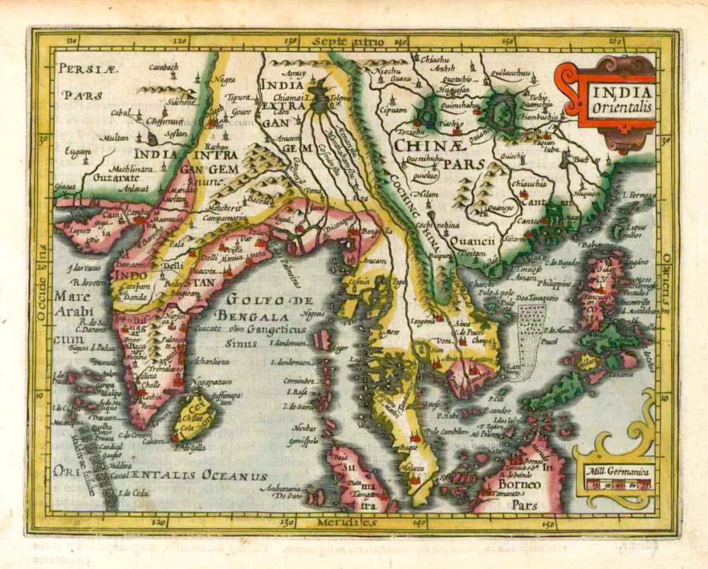
India Orientalis. 1607
Southeast Asia, by G. Mercator - J. Hondius (small)
[Item number: 25186]
From the Cloppenburg edition
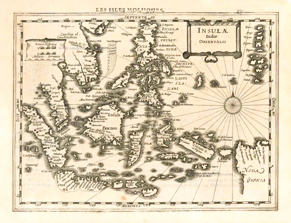
Insulae Indiae Orientalis. 1630
Southeast Asia, by G. Mercator - J. Hondius.
[Item number: 25234]
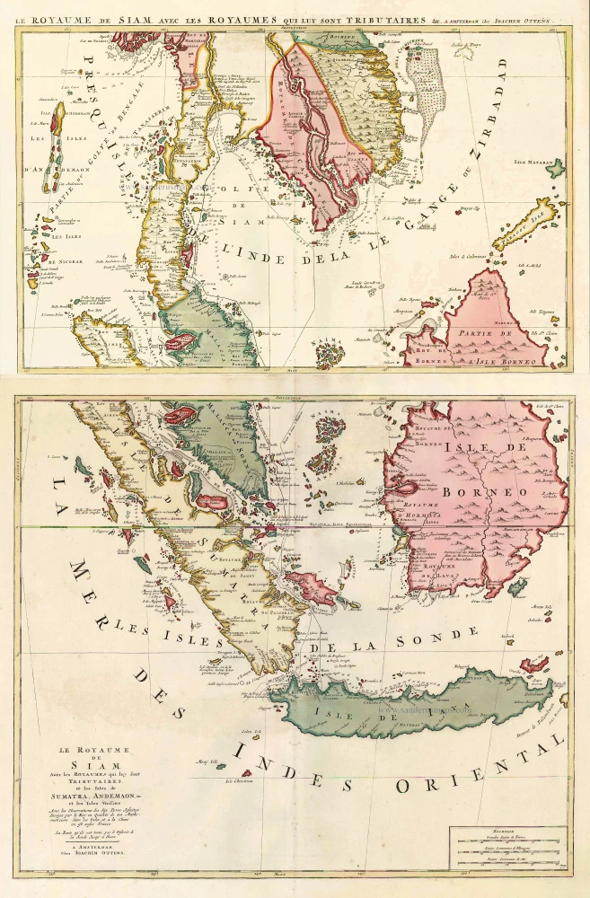
Le Royaume de Siam avec les Royaumes qui luy sont Tributaires, et les Isles de Sumatra, Andemaon, etc. et les Isles Voisine. c. 1700
Southeast Asia, by J. Ottens.
[Item number: 25716]
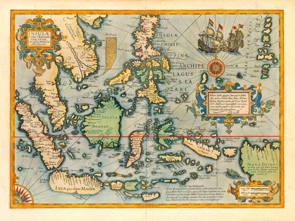
The most elegant and decorative map of East Indies
Insulae Indiae Orientalis Praecipuae, in quibus Moluccae celeberrimae sunt. 1623
East Indies by Jodocus Hondius.
[Item number: 27820]
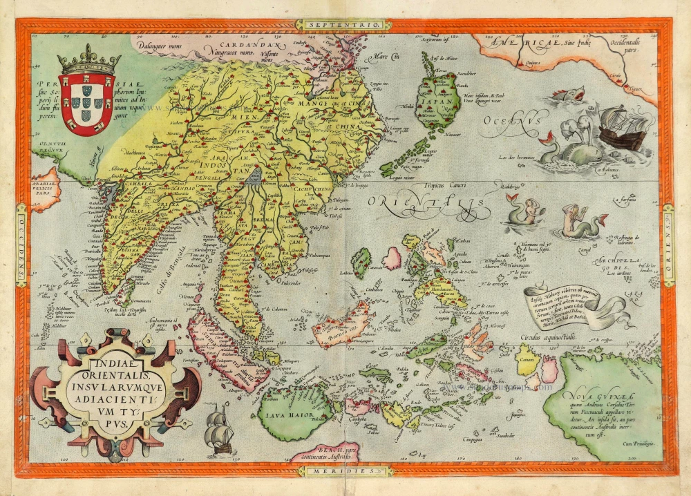
A very important map of the region
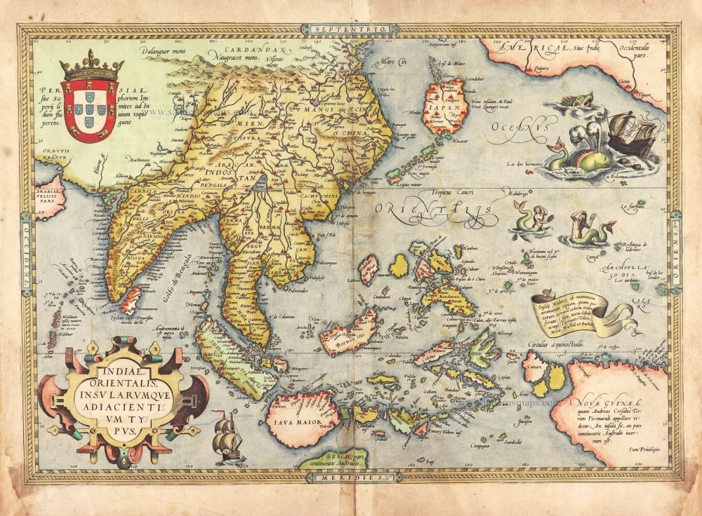
Indiae Orientalis Insularumque Adiacientium Typus. 1572
Southeast Asia, by Abraham Ortelius.
[Item number: 28046]
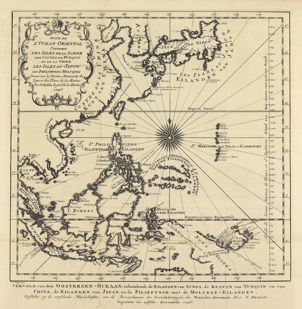
Suite de L'Ocean Oriental Contenant Les Isles de la Sonde Les Costes de Tunquin et de la Chine Les Isles du Japon les Philippines Moluques. 1747
Southeast Asia by Jacques Nicolas Bellin.
[Item number: 28189]
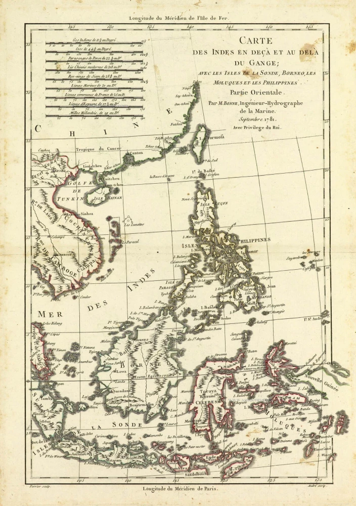
Carte des Indes en deçà et au dela du Gange; avec les Isles de la Sonde, Borneo, les Moluques et les Philippines. Partie Orientale. 1690
Southeast Asia by Rigobert Bonne.
[Item number: 28304]
Scarce
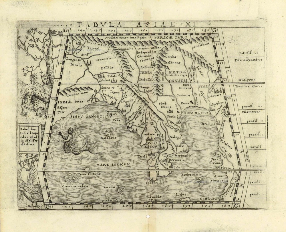
Tabula Asiae XI. 1548
Southeast Asia by Giacomo Gastaldi / Ptolemy.
[Item number: 28362]
Very rare first 1570 A edition.
Indiae Orientalis Insularumque Adiacientium Typus. 1570
Southeast Asia, by Abraham Ortelius.
[Item number: 30592]
new