
The Ottoman Empire, by Francesco Santini. 1776-79

Francesco and Paolo Santini (c.1729-1793)
Francesco Santini, a Venetian publisher, acquired the printing plates of Vaugondy’s Atlas Universel …, a commercial and cartographic success, with widespread influence on mapmakers throughout Europe. Together with his brother Paolo, he commissioned a new set of plates and reissued the atlas in 1776. The following year, Paolo Santini assigned all his publication rights to M. Remondini, who in 1777 reissued the same atlas but with his name.
Sr. Janvier Jean Denis [Robert] (? - 1776)
A French cartographer who worked in Paris from about 1746.
He collaborated with other cartographers and publishers in producing a considerable number of maps, many of which were used in general atlases by William Fadan, P. Santini and others.
Turquie d'Europe.
Item Number: 26972 Authenticity Guarantee
Category: Antique maps > Asia > Turkey - Cyprus
Old, antique map of Greece and a part of Turkey, by Francesco Santini.
Cartographer: Jean Denis Janvier (Sieur)
First state with the imprint of Remondini: with engraved page numbers in the top right corner: "P.I.54".
Date of the first edition: 1776
Date of this map: 1776
Copper engraving, printed on paper.
Size (not including margins): 48.5 x 64cm (18.9 x 25 inches)
Verso: Blank
Condition: Original coloured in outline, excellent.
Condition Rating: A+
References: Zacharakis, 1737/1145(b).
From: Atlas Universel dressé sur les meilleures cartes modernes. Venice, Remondini, 1776.
Francesco and Paolo Santini (c.1729-1793)
Francesco Santini, a Venetian publisher, acquired the printing plates of Vaugondy’s Atlas Universel …, a commercial and cartographic success, with widespread influence on mapmakers throughout Europe. Together with his brother Paolo, he commissioned a new set of plates and reissued the atlas in 1776. The following year, Paolo Santini assigned all his publication rights to M. Remondini, who in 1777 reissued the same atlas but with his name.
Sr. Janvier Jean Denis [Robert] (? - 1776)
A French cartographer who worked in Paris from about 1746.
He collaborated with other cartographers and publishers in producing a considerable number of maps, many of which were used in general atlases by William Fadan, P. Santini and others.
Related items

Tabula Nova Geographica Natoliae et Asiae Minoris. c. 1740
Turkey - Cyprus by N. Visscher II - P. Schenk.
[Item number: 25841]

Turquie en Europe. 1713
Greece, by P. Van der Aa.
[Item number: 26076]

Imperium Turcicum in Europa, Asia et Africa, divisum in sua Regna et Regiones, nempe Graeciam, Natoliam, Armeniam, Arabiam, Aegyptum, Regna Algeriae, Tunetanum, Tripoleos et Barcae, cum reliquis adjacentibus regionibus. c. 1700
Ottoman Empire by Gerard and Leonard Valck.
[Item number: 28322]

Turcicum Imperium. ca. 1691-96
Ottoman Empire, by De Wit F.
[Item number: 28988]

Carte de l'Empire Othoman considerée dans les Etats de cette Puissance, et des Etats qui l'avoisinent ou qui luy sont Tributaires, ainsi que deux petites Cartes pour conduire à l'Histoire Universelle, et en particulier à l'Histoire d'Alexandre le Grand, 1714
Ottoman Empire, by Zacharias Châtelain.
[Item number: 29399]

Estats de l'Empire du Grand Seigneur des Turqs ou Sultan des Ottomans en Asie, en Afrique, et en Europe. 1659
Ottoman Empire by Nicolas Sanson.
[Item number: 29713]

Estats de l'Empire du Grand Seigneur des Turcs en Europe, en Asie, et en Afrique ... 1692
Ottoman Empire by N. Sanson, so-called published by Hubert Jaillot. (Pirated edition by Pierre Mortier).
[Item number: 31198]

Turcicum Imperium. 1618
Ottoman Empire, by Petrus Bertius
[Item number: 32176]

Scarce
Accuratissima et Maxima Totius Turcici Imperii Tabula cum omnibus suis Regionibus. c. 1680
Ottoman Empire by Danckerts J.
[Item number: 32518]

Turcici Imperii Imago. 1628
Ottoman Empire, by Jodocus Hondius,
[Item number: 32688]

Turcici Imperii Descriptio. 1579
Ottoman Empire by Ortelius Abraham
[Item number: 32692]
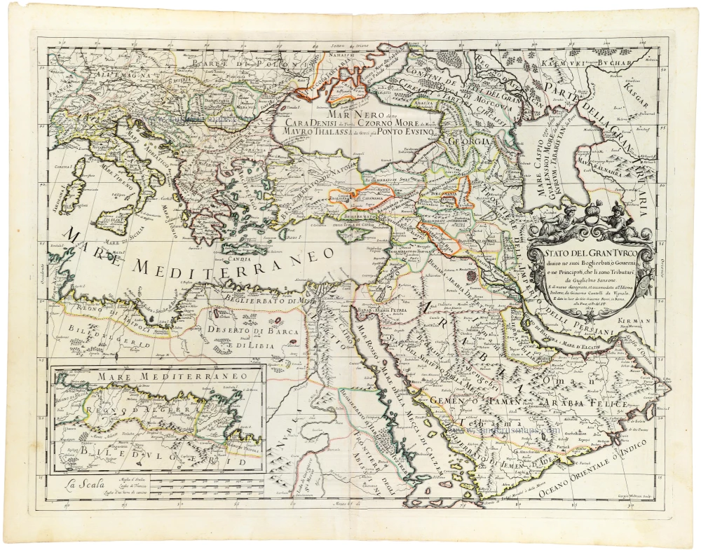
Stato del Gran Turco diviso ne suoi Beglierbau, ò Governi, e ne Principati, che li sono Tributari. 1687
Ottoman Empire, by Guillaume Sanson, adapted by Giacomo Cantelli da Vignola, and published by Giovanni de Rossi.
[Item number: 32955]

Turcicum Imperium. 1666
Ottoman Empire by Joannes Janssonius.
[Item number: 33094]
new