
Ottoman Empire, by Petrus Bertius 1618

Petrus Bertius (1565-1629)
Petrus Bertius, born at Beveren, Flanders, in 1565, was related to Pieter van den Keere (Kaerius) and Jodocus Hondius. Both famous cartographers were brothers-in-law of Petrus Bertius. As a refugee, he settled in Amsterdam, and after finishing his studies, he became a professor of mathematics and librarian at the University of Leiden. In 1618, he became a cosmographer and historiographer for Louis XIII of France. He lived in Paris, where he died in 1629.
Petrus Bertius's remarkable work ethic is evident in the numerous geographical and theological works he produced. His contributions to the works of Clüver and Herrera further solidified his reputation in geography.
His fame among geographers was established by his text in the pocket atlas Tabularum Geographicarum and by his edition of Ptolemy’s Geographia.
The origin of the Tabularum Geographicum lies in the well-known miniature atlas Caert thresoor, published by Barent Langenes in 1598 in Middelburg. Bertius engraved 169 maps for this small but attractive atlas, sold for the first time in 1599 by Cornelis Claesz in Amsterdam. In 1600, Claesz published the pocket atlas with a Latin text composed by Petrus Bertius. From then on, new editions, often enlarged with new maps, regularly appeared, subsequently published by Cornelis Claesz, Jodocus Hondius, Johannes Janssonius and ultimately, in 1649, by Claes Jansz. Visscher.
Koeman divides this series of pocketbooks into two atlases: The Caert-thresoor, published by Langenes and Claesz., with five editions between 1598 and 1609, and the Tabularum Geographicarum Contractarum by Petrus Bertius with ten editions between 1600 and 1650.
Turcicum Imperium.
Item Number: 32176 Authenticity Guarantee
Category: Antique maps > Asia > Middle East
Ottoman Empire, by Petrus Bertius.
Title: Turcicum Imperium.
Date of the first edition: 1616.
Date of this map: 1618.
Copper engraving, printed on paper.
Image size: 95 x 135mm (3¾ x 5¼ inches).
Sheet size: 120 x 185mm (4¾ x 7¼ inches).
Verso: French text.
Condition: Excellent.
Condition Rating: A+.
From: Bertius P. La Geographie Racourcie de Pierre Bertius. Amsterdam, Jodocus Hondius jr. 1618. (Van der Krogt 3, 342:11)
Petrus Bertius (1565-1629)
Petrus Bertius, born at Beveren, Flanders, in 1565, was related to Pieter van den Keere (Kaerius) and Jodocus Hondius. Both famous cartographers were brothers-in-law of Petrus Bertius. As a refugee, he settled in Amsterdam, and after finishing his studies, he became a professor of mathematics and librarian at the University of Leiden. In 1618, he became a cosmographer and historiographer for Louis XIII of France. He lived in Paris, where he died in 1629.
Petrus Bertius's remarkable work ethic is evident in the numerous geographical and theological works he produced. His contributions to the works of Clüver and Herrera further solidified his reputation in geography.
His fame among geographers was established by his text in the pocket atlas Tabularum Geographicarum and by his edition of Ptolemy’s Geographia.
The origin of the Tabularum Geographicum lies in the well-known miniature atlas Caert thresoor, published by Barent Langenes in 1598 in Middelburg. Bertius engraved 169 maps for this small but attractive atlas, sold for the first time in 1599 by Cornelis Claesz in Amsterdam. In 1600, Claesz published the pocket atlas with a Latin text composed by Petrus Bertius. From then on, new editions, often enlarged with new maps, regularly appeared, subsequently published by Cornelis Claesz, Jodocus Hondius, Johannes Janssonius and ultimately, in 1649, by Claes Jansz. Visscher.
Koeman divides this series of pocketbooks into two atlases: The Caert-thresoor, published by Langenes and Claesz., with five editions between 1598 and 1609, and the Tabularum Geographicarum Contractarum by Petrus Bertius with ten editions between 1600 and 1650.
Related items

Turquie d'Europe. 1776-79
The Ottoman Empire, by Francesco Santini.
[Item number: 26972]

Dardanelo Fortezza dala parte dela Gretia posta nellabochadella stretto di Costatinop. del signor Turcho. c. 1575
Dardanelles (Ottoman Fort) by Giovanni Francesco Camocio
[Item number: 27624]
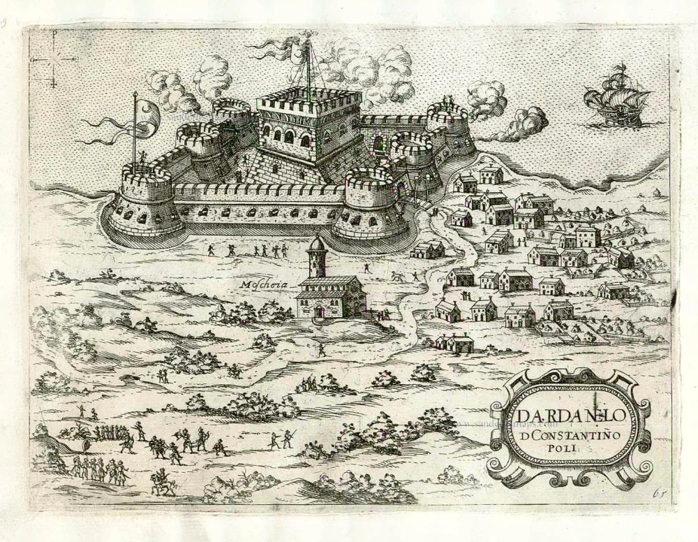
Dardanelo D Constantinopoli. c. 1575
Dardanelles (Ottoman Fort) by Giovanni Francesco Camocio
[Item number: 27625]

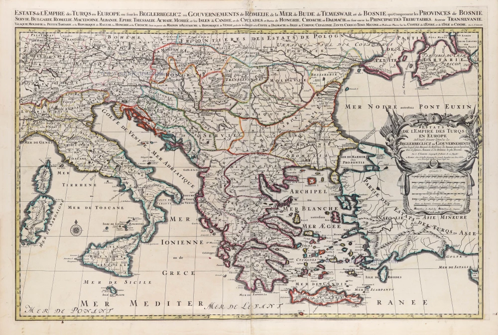
Estats de l'Empire des Turqs en Europe. c. 1705
European Ottoman Empire by Nicolas Sanson, published by Pieter Mortier.
[Item number: 27770]

Imperium Turcicum in Europa, Asia et Africa, divisum in sua Regna et Regiones, nempe Graeciam, Natoliam, Armeniam, Arabiam, Aegyptum, Regna Algeriae, Tunetanum, Tripoleos et Barcae, cum reliquis adjacentibus regionibus. c. 1700
Ottoman Empire by Gerard and Leonard Valck.
[Item number: 28322]

Turcicum Imperium. ca. 1691-96
Ottoman Empire, by De Wit F.
[Item number: 28988]

Turcicum Imperium. 1652-53
Ottoman Empire by Henricus Hondius.
[Item number: 29168]

Danubii Fluvii Sive Turcici Imperii in Europa. c. 1705
Danube and European Ottoman Empire, by Frederick de Wit.
[Item number: 29279]

Carte de l'Empire Othoman considerée dans les Etats de cette Puissance, et des Etats qui l'avoisinent ou qui luy sont Tributaires, ainsi que deux petites Cartes pour conduire à l'Histoire Universelle, et en particulier à l'Histoire d'Alexandre le Grand, 1714
Ottoman Empire, by Zacharias Châtelain.
[Item number: 29399]

Estats de l'Empire du Grand Seigneur des Turqs ou Sultan des Ottomans en Asie, en Afrique, et en Europe. 1659
Ottoman Empire by Nicolas Sanson.
[Item number: 29713]

Estats de l'Empire du Grand Seigneur des Turcs en Europe, en Asie, et en Afrique ... 1692
Ottoman Empire by N. Sanson, so-called published by Hubert Jaillot. (Pirated edition by Pierre Mortier).
[Item number: 31198]
Estats de l'Empire des Turqs en Europe. 1692
European Ottoman Empire by N. Sanson, so-called published by Hubert Jaillot. (Pirated edition by Pierre Mortier).
[Item number: 31199]

Scarce
Accuratissima et Maxima Totius Turcici Imperii Tabula cum omnibus suis Regionibus. c. 1680
Ottoman Empire by Danckerts J.
[Item number: 32518]

Turcici Imperii Imago. 1628
Ottoman Empire, by Jodocus Hondius,
[Item number: 32688]

Turcici Imperii Descriptio. 1579
Ottoman Empire by Ortelius Abraham
[Item number: 32692]
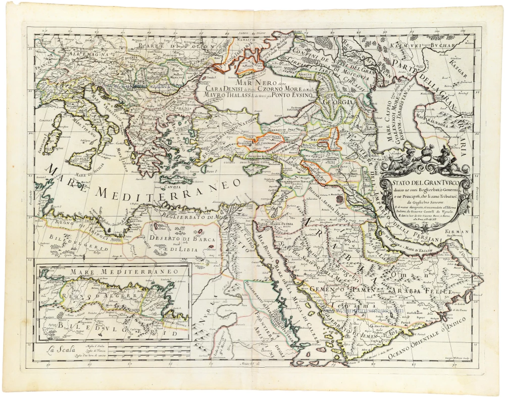
Stato del Gran Turco diviso ne suoi Beglierbau, ò Governi, e ne Principati, che li sono Tributari. 1687
Ottoman Empire, by Guillaume Sanson, adapted by Giacomo Cantelli da Vignola, and published by Giovanni de Rossi.
[Item number: 32955]

Turcicum Imperium. 1666
Ottoman Empire by Joannes Janssonius.
[Item number: 33094]
new