
Old antique chart of Australia, by Melchisedech Thevenot. 1663
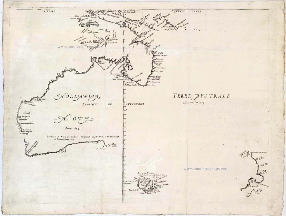

Thevenot's Tasman map is a cornerstone map of the mapping of Australia. It is one of the first to show parts of the Australian coastline in detail, based on Tasman's 1644 voyage. It shows part of the coast of New Guinea, Tasmania, and much of the east coast of Australia, and is a basic work of Australian cartography. This first state has no rhumblines and does not show the route of Tasman.
Melchisedech Thévenot (1620-1692)
Melchisedech Thévenot was a French diplomat, scientist, and travel writer. He was a scholar with interests in mathematics, physics, and medicine, acting as the patron of several early scientific societies and contributing to the formation of the Académie des Sciences. His early career included two missions to Italy in the 1640s and 1650s, and it was there that he first developed an interest in the study of Oriental languages. In 1663, he published the first part of “Relations de Divers Voyages”, a work that would secure his reputation as one of the essential travel compilers of the seventeenth century. He would publish a second and third part in 1666, a fourth in 1672, and a final fifth part was being assembled in 1692 when Thévenot died.
Hollandia Nova detecta 1644. - Terre Australe decouuerte l'an 1644.
Item Number: 26341 Authenticity Guarantee
Category: Antique maps > Australia
Old, antique chart of Australia, New Zealand, and New Guinea, by Melchisedech Thevenot.
Date of the first edition: 1663
Date of this map: 1663
Copper engraving, printed on paper.
Size (not including margins): 38 x 52.5cm (14.8 x 20.5 inches)
Verso: Blank
Condition: New upper left corner (in white area).
Condition Rating: A
References: Clancy, p.82 Map 6.12; Schilder (Australia), Map 85; Tooley (Australia), #12148; Suarez (SE Asia), p.208.
From: Relations de Divers Voyages Curieux. 1663.
Thevenot's Tasman map is a cornerstone map of the mapping of Australia. It is one of the first to show parts of the Australian coastline in detail, based on Tasman's 1644 voyage. It shows part of the coast of New Guinea, Tasmania, and much of the east coast of Australia, and is a basic work of Australian cartography. This first state has no rhumblines and does not show the route of Tasman.
Thevenot's Tasman map is a cornerstone map of the mapping of Australia. It is one of the first to show parts of the Australian coastline in detail, based on Tasman's 1644 voyage. It shows part of the coast of New Guinea, Tasmania, and much of the east coast of Australia, and is a basic work of Australian cartography. This first state has no rhumblines and does not show the route of Tasman.
Melchisedech Thévenot (1620-1692)
Melchisedech Thévenot was a French diplomat, scientist, and travel writer. He was a scholar with interests in mathematics, physics, and medicine, acting as the patron of several early scientific societies and contributing to the formation of the Académie des Sciences. His early career included two missions to Italy in the 1640s and 1650s, and it was there that he first developed an interest in the study of Oriental languages. In 1663, he published the first part of “Relations de Divers Voyages”, a work that would secure his reputation as one of the essential travel compilers of the seventeenth century. He would publish a second and third part in 1666, a fourth in 1672, and a final fifth part was being assembled in 1692 when Thévenot died.
Related items
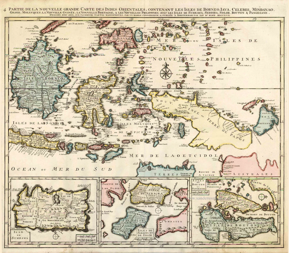
Partie de la Nouvelle Grande Carte des Indes Orientales, Contenant les Isles de Borneo, Iava, Celebes, Mindanao ... 1792
Indonesia - New Guinea - Australia by J.B. Elwe.
[Item number: 2293]
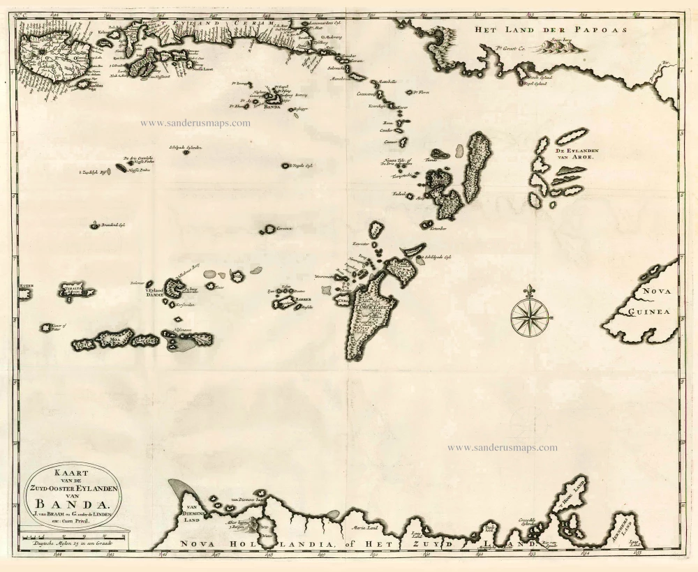
Kaart van de Zuyd-Ooster Eylanden van Banda. 1724-26
The Banda Islands (Southeast) & Northern Australia, by Fr. Valentyn.
[Item number: 26608]
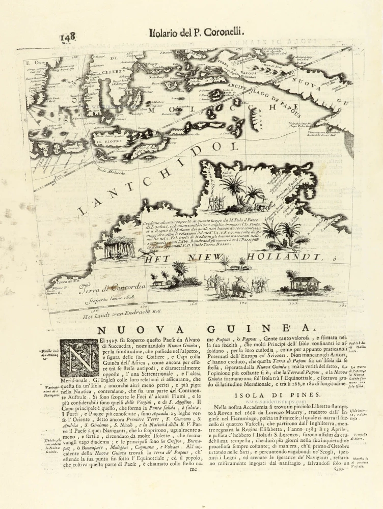
Nuova Guinea. 1696
Globe gore with Northern Australia and the East Indies, by V.M. Coronelli.
[Item number: 30785]