
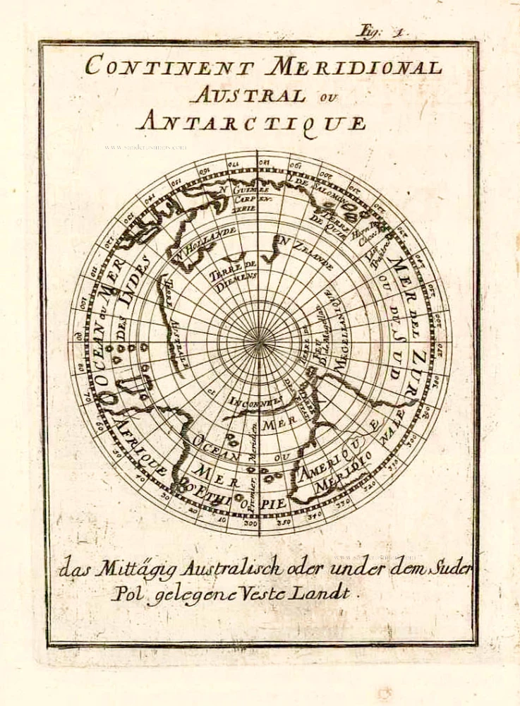
Old antique map of the Southern Hemisphere & Antartica, by A.M. Mallet. 1685
Allain Manesson Mallet (1630-1706)
Allain Manesson Mallet was born the son of Philippe Mallet in 1630. His father was an ingénieur ordinaire to Louis XIV and a professor of mathematics around 1645. Allain, at first, carried muskets to the regiment of guards of Louis XIV and then became an engineer like his father. Later, becoming a sergeant-major of artillery, he travelled extensively to Spain and Portugal, supervising the fortifications there. On his return to France, he was named master of mathematics. In 1671, he published the Travaux de Mars, a book on military fortifications. He followed in 1683 with the work concerned here, the Description de L'Univers, a five-volume geographical text covering all subject aspects. It was heavily illustrated with nearly 700 prints and maps. (Burden)
Continent Meridional Australe ou Antarctique.
Item Number: 26600 Authenticity Guarantee
Category: Antique maps > Australia
Old, antique map of the Southern Hemisphere & Antartica, by A.M. Mallet.
Shows Southern Africa, South America, Antartica, Australia and New Zealand.
Date of the first edition: 1683
Date of this map: 1685
Copper engraving, printed on paper.
Size (not including margins): 15 x 11.5cm (5.9 x 4.5 inches)
Verso: Blank
Condition: Excellent.
Condition Rating: A+
References: Tooley (Australia), #887.
From: Beschreibung des ganzen Welt-Kreises. Frankfurt, 1685.
Allain Manesson Mallet (1630-1706)
Allain Manesson Mallet was born the son of Philippe Mallet in 1630. His father was an ingénieur ordinaire to Louis XIV and a professor of mathematics around 1645. Allain, at first, carried muskets to the regiment of guards of Louis XIV and then became an engineer like his father. Later, becoming a sergeant-major of artillery, he travelled extensively to Spain and Portugal, supervising the fortifications there. On his return to France, he was named master of mathematics. In 1671, he published the Travaux de Mars, a book on military fortifications. He followed in 1683 with the work concerned here, the Description de L'Univers, a five-volume geographical text covering all subject aspects. It was heavily illustrated with nearly 700 prints and maps. (Burden)
Related items
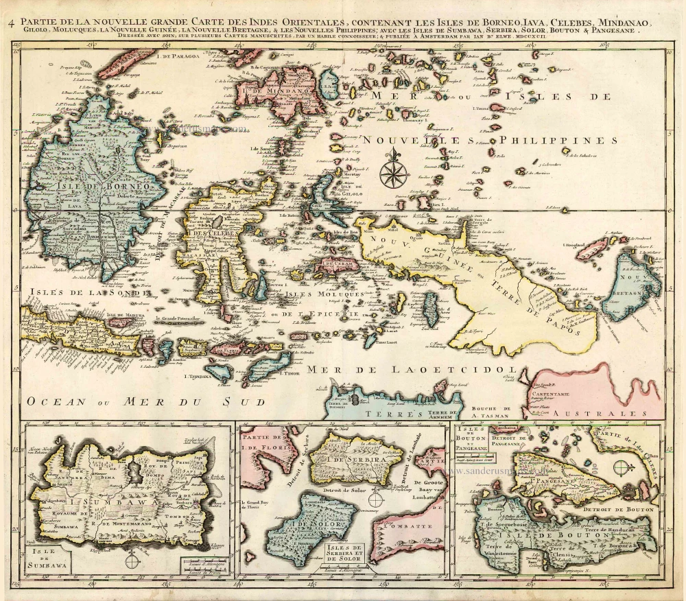
Partie de la Nouvelle Grande Carte des Indes Orientales, Contenant les Isles de Borneo, Iava, Celebes, Mindanao ... 1792
Indonesia - New Guinea - Australia by J.B. Elwe.
[Item number: 2293]
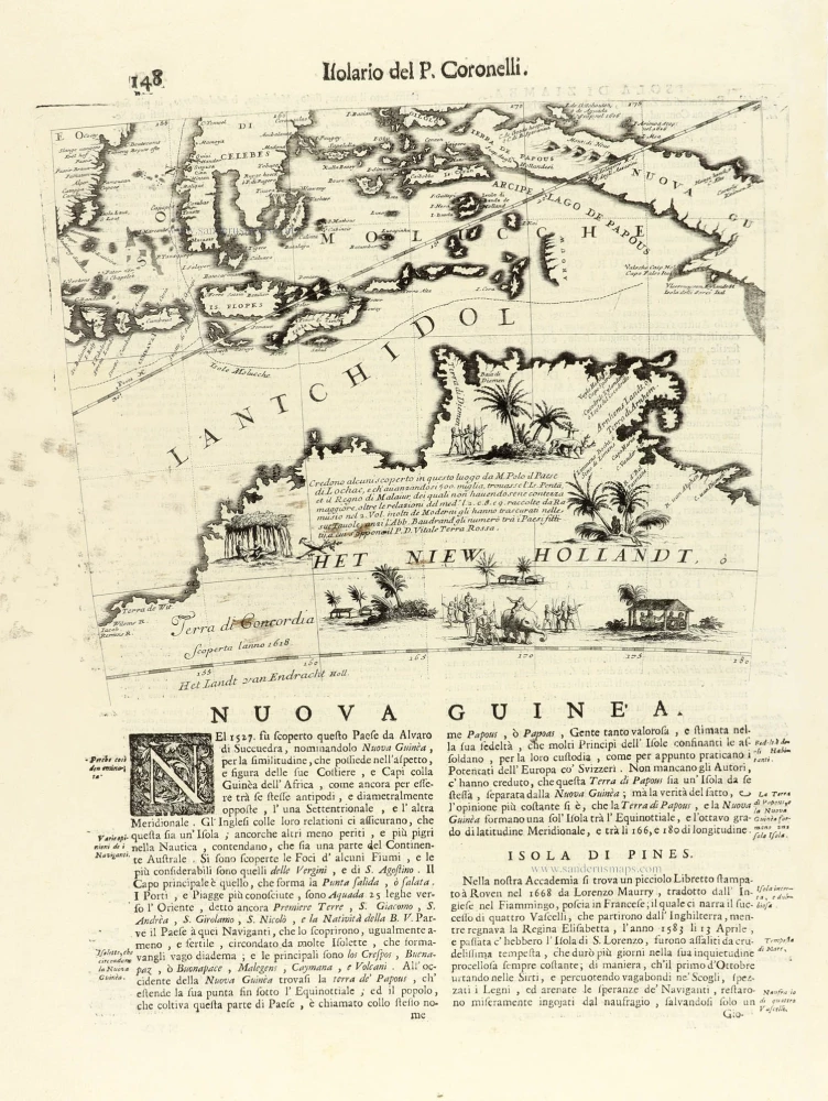
Nuova Guinea. 1696
Globe gore with Northern Australia and the East Indies, by V.M. Coronelli.
[Item number: 30785]