
Ypres (Ieper) by Sr. S. de Beaulieu - three plates. ca. 1668


Sr. Sébastien de Beaulieu (1612 - 1674)
Sébastien de Pontault, Sieur de Beaulieu was born around 1612. He entered the service of the king at the age of 15. Despite his young age, he obtained the post of commissioner of artillery in 1628. He had a successful career in the military but was severely wounded several times. In 1642, he received a royal privilege for creating and publishing battle plans. At the request of the king, he had numerous sieges engraved.
de Beaulieu left us fourteen small oblong atlases of plans and profiles of the cities of France, commonly called “Les Petits Beaulieu”, and a large folio atlas of the battles of Louis XIII and Louis XIV, known as “le Grand Beaulieu”. These works are the culmination of a long career as a military engineer.
Beaulieu died in 1674 before having completed his collection of battle plans. His niece, Reine-Michèle de Beaulieu, completed the atlas in 1694.
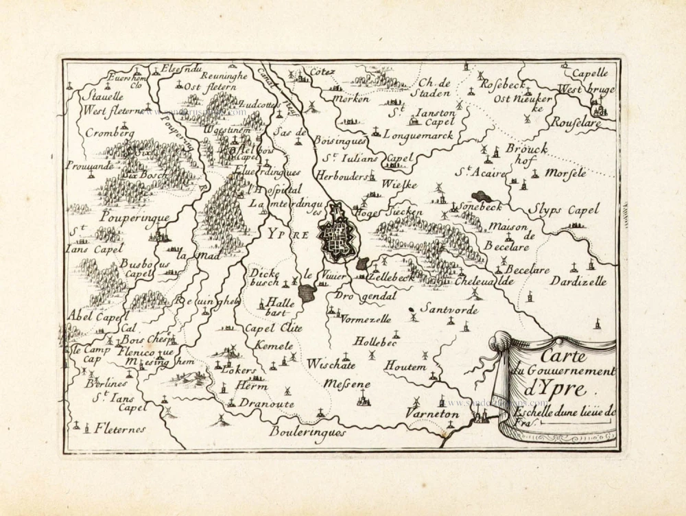
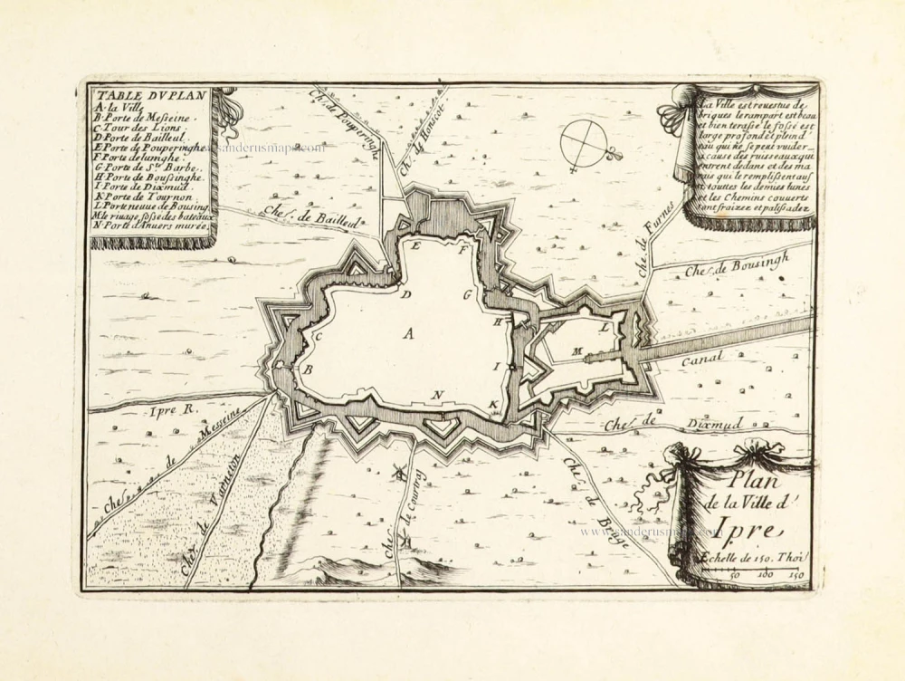
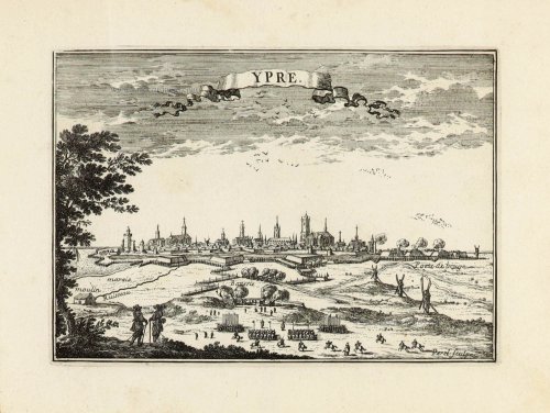
Ypre. - Carte du Gouvernement d'Ypre. - Plan de la Ville d'Ipre.
Item Number: 30299 Authenticity Guarantee
Category: Antique maps > Europe > Belgium - Cities
Ypres (Ieper) by Sr. S. de Beaulieu - three plates.
Panoramic view, map of the region, and plan of the city of Ypres.
Titles: Ypre. - Carte du Gouvernement d'Ypre. - Plan de la Ville d'Ipre.
Date: ca. 1668.
Copper engravings, printed on paper.
Image size each: 105 x 155mm (4.13 x 6.1 inches).
Sheet size each: 155 x 190mm (6.1 x 7.48 inches).
Verso: Blank.
Condition: Excellent.
Condition Rating: A+.
From: Les plans et profils des principales villes et lieux considerables du comté de Flandre avec les cartes generales, et les particulieres de chaque gouvernement. A Paris par le chevalier de Beaulieu. (Pastoureau, p. 24, Beaulieu VII Aa)
Sr. Sébastien de Beaulieu (1612 - 1674)
Sébastien de Pontault, Sieur de Beaulieu was born around 1612. He entered the service of the king at the age of 15. Despite his young age, he obtained the post of commissioner of artillery in 1628. He had a successful career in the military but was severely wounded several times. In 1642, he received a royal privilege for creating and publishing battle plans. At the request of the king, he had numerous sieges engraved.
de Beaulieu left us fourteen small oblong atlases of plans and profiles of the cities of France, commonly called “Les Petits Beaulieu”, and a large folio atlas of the battles of Louis XIII and Louis XIV, known as “le Grand Beaulieu”. These works are the culmination of a long career as a military engineer.
Beaulieu died in 1674 before having completed his collection of battle plans. His niece, Reine-Michèle de Beaulieu, completed the atlas in 1694.
Related items

Ipern. 1659
Ieper, by Matthäus Merian & Martin Zeiller.
[Item number: 2241]

Yperen. 1656
Ieper, by N. Visscher & P.H. Schut.
[Item number: 2774]
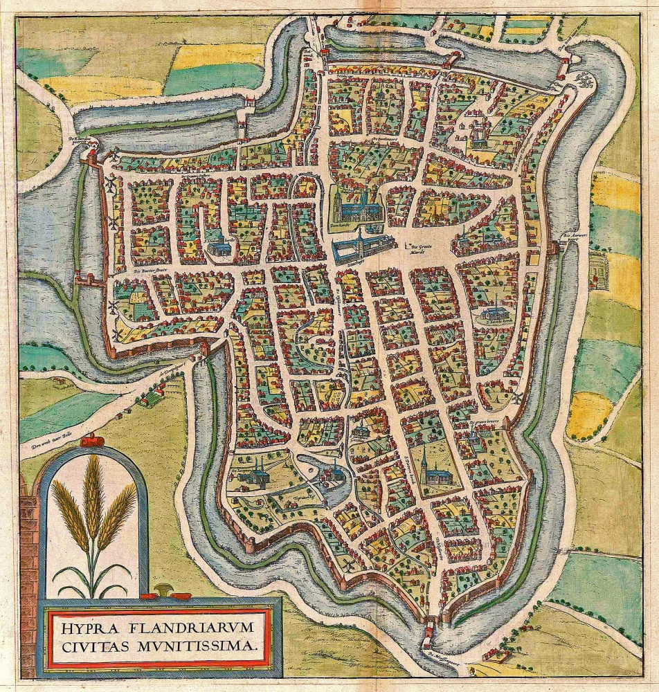
Hypra Flandriarum Civitas Munitissima 1597
Ypres (Ieper), by Georg Braun and Frans Hogenberg.
[Item number: 5233]
Ypern. 1726
Ypres (Ieper), by D. Fassmann.
[Item number: 5959]

Hypra Flandriarum Civitas Munitissima 1597
Ypres (Ieper), by Georg Braun and Frans Hogenberg.
[Item number: 23976]

Iprensis Episcopatus. 1663
The bishopric of Ieper, by J. Blaeu.
[Item number: 26221]

Famous and beautiful map
Nova et Exacta Tabula Geographica Salae et Castellaniae Iprensis Anno MDCXXXXI. 1732
Ypres (Ieper) Castellania, by Sanderus A.
[Item number: 27434]

Hollebeke 1641
Ieper - Hollebeke, by Antonius Sanderus
[Item number: 32721]
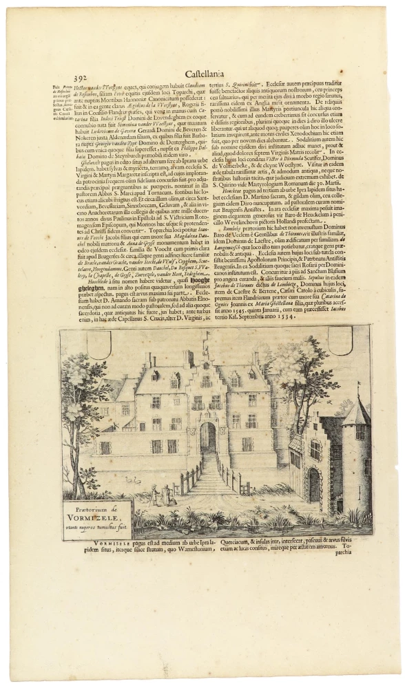
Praetorium de Vormizele, utante nuperos tumultus fuit. 1641
Ieper - Voormezele, by Antonius Sanderus
[Item number: 32723]
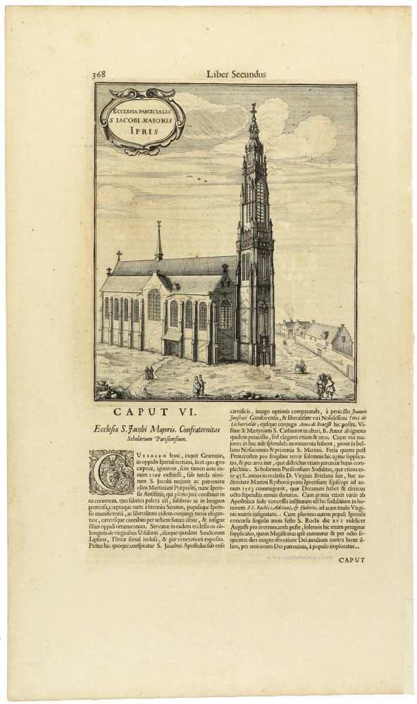
Ecclesia Parcecialis S Iacobi Maioris Ipris. 1641
Ieper - Kerk St.-Jacob, by Antonius Sanderus
[Item number: 32724]

Nova Et Exacta Tabula Geographica Salae Et Castellaniae Iprensis - De Casselrie Van Ipre - La Chastelenie D'ipre Anno MDCXXXXI. 1641
Ieper (Castellania), by A. Sanderus.
[Item number: 32725]

Praetorium Iprense Vulgo De Halle van Yperen 1641
Ieper - Halle met belfort & Marktplein, door Antonius Sanderus.
[Item number: 32726]

Ypra. 1641-1644
Ypres (Ieper), by Antonius Sanderus.
[Item number: 32729]

Rare first state
Iprensis Episcopatus. 1641-1644
The bishopric of Ypres (Ieper), by Antonius Sanderus, published by Henricus Hondius.
[Item number: 32850]
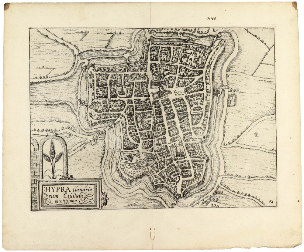
Hypra flandriarum Civitatu minitißima; 1612
Ieper (Ypres) by Guicciardini Lodovico
[Item number: 33003]
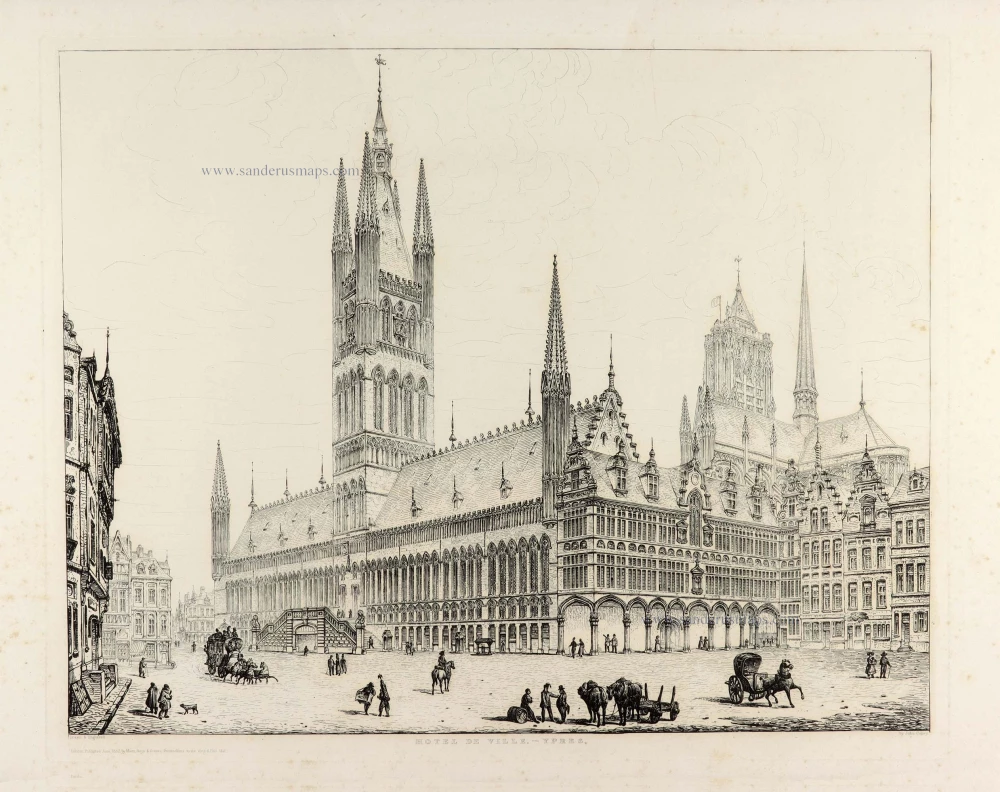
Hotel de Ville - Ypres 1832
Ieper (Ypres) , City Hall, by J. Coney.
[Item number: 33112]
new