
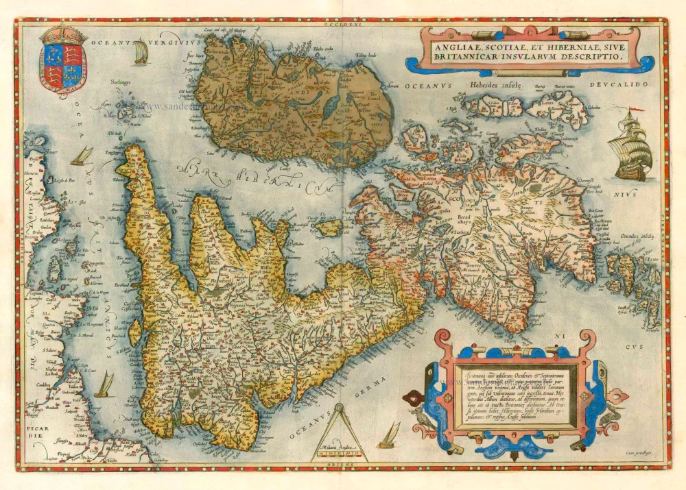
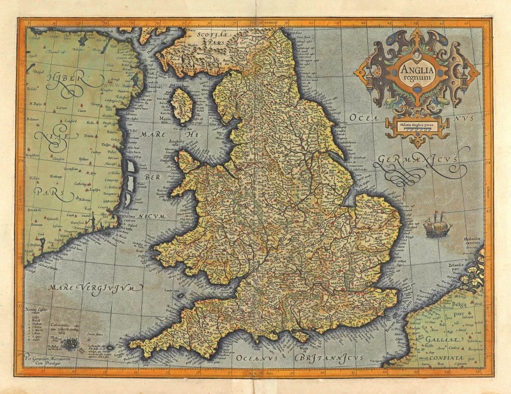
England by A. Ortelius. 1601
The item displayed on this page has been sold. However, we have a similar map in stock:
England by A. Ortelius. 1584
Angliae Regni Florentissimi nova descriptio.
[Item number: 30145]


Abraham Ortelius (1527-1598)
The maker of the 'first atlas', the Theatrum Orbis Terrarum (1570), was born on 4 April 1527 into an old Antwerp family. He learned Latin and studied Greek and mathematics.
Abraham and his sisters Anne and Elizabeth took up map colouring. He was admitted to the Guild of St. Luke as an "illuminator of maps." Besides colouring maps, Ortelius was a dealer in antiques, coins, maps, and books, with the book and map trade gradually becoming his primary occupation.
Business went well because his means permitted him to start an extensive collection of medals, coins, antiques, and a library of many volumes. In addition, he travelled a lot and visited Italy and France, made contacts everywhere with scholars and editors, and maintained extensive correspondence with them.
In 1564 he published his first map, a large and ambitious world wall map. The inspiration for this map may well have been Gastaldi's large world map. In 1565 he published a map of Egypt and a map of the Holy Land, a large map of Asia followed.
In 1568 the production of individual maps for his atlas Theatrum Orbis Terrarum was already in full swing. He completed the atlas in 1569, and in May of 1570, the Theatrum was available for sale. It was one of the most expensive books ever published.
This first edition contained seventy maps on fifty-three sheets. Franciscus Hogenberg engraved the maps.
Later editions included Additamenta (additions), resulting in Ortelius' historical atlas, the Parergon, mostly bound together with the atlas. The Parergon can be called a truly original work of Ortelius, who drew the maps based on his research.
The importance of the Theatrum Orbis Terrarum for geographical knowledge in the last quarter of the sixteenth century is difficult to overemphasize. Nothing was like it until Mercator's atlas appeared twenty-five years later. Demand for the Theatrum was remarkable. Some 24 editions appeared during Ortelius's lifetime and another ten after his death in 1598. Editions were published in Dutch, German, French, Spanish, English, and Italian. The number of map sheets grew from 53 in 1570 to 167 in 1612 in the last edition.
In 1577, engraver Philip Galle and poet-translator Pieter Heyns published the first pocket-sized edition of the Theatrum, the Epitome. The work was trendy. Over thirty editions of this Epitome were published in different languages.
Angliae Regni Florentissimi nova descriptio
Item Number: 5714 Authenticity Guarantee
Category: Antique maps > Europe > British Isles
England by A. Ortelius.
Title: Angliae Regni Florentissimi nova descriptio
Date of the first edition: 1573.
Date of this map: 1601.
Date on map: 1573.
Copper engraving, printed on paper.
Image size: 380 x 465mm (14.96 x 18.31 inches).
Sheet size: 420 x 550mm (16.54 x 21.65 inches).
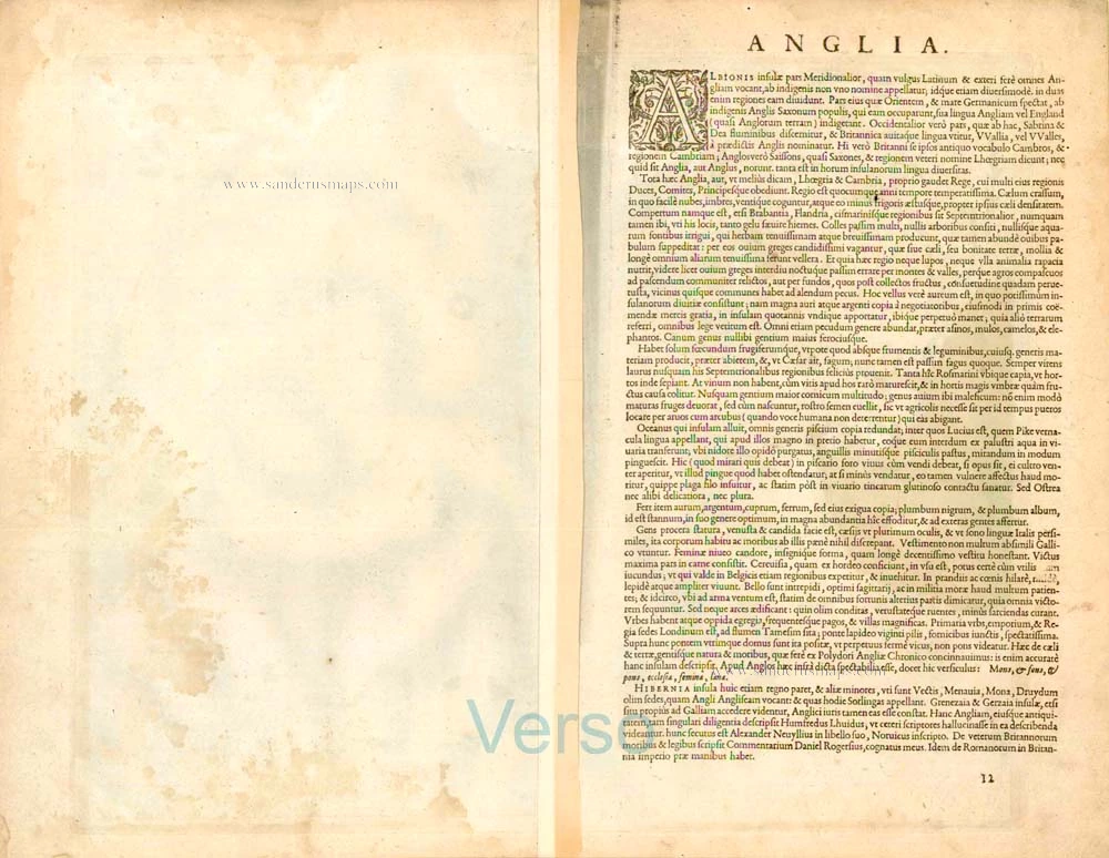
Verso: Latin text.
Condition: Original coloured, excellent.
Condition Rating: A+.
From: Ortelius A.,Theatrum Orbis Terrarum Abrahami Ortelii Antverp. Geographi Regii. Antwerpen, Plantin Press, 1601. (Van der Krogt 3, 1:052)
Abraham Ortelius (1527-1598)
The maker of the 'first atlas', the Theatrum Orbis Terrarum (1570), was born on 4 April 1527 into an old Antwerp family. He learned Latin and studied Greek and mathematics.
Abraham and his sisters Anne and Elizabeth took up map colouring. He was admitted to the Guild of St. Luke as an "illuminator of maps." Besides colouring maps, Ortelius was a dealer in antiques, coins, maps, and books, with the book and map trade gradually becoming his primary occupation.
Business went well because his means permitted him to start an extensive collection of medals, coins, antiques, and a library of many volumes. In addition, he travelled a lot and visited Italy and France, made contacts everywhere with scholars and editors, and maintained extensive correspondence with them.
In 1564 he published his first map, a large and ambitious world wall map. The inspiration for this map may well have been Gastaldi's large world map. In 1565 he published a map of Egypt and a map of the Holy Land, a large map of Asia followed.
In 1568 the production of individual maps for his atlas Theatrum Orbis Terrarum was already in full swing. He completed the atlas in 1569, and in May of 1570, the Theatrum was available for sale. It was one of the most expensive books ever published.
This first edition contained seventy maps on fifty-three sheets. Franciscus Hogenberg engraved the maps.
Later editions included Additamenta (additions), resulting in Ortelius' historical atlas, the Parergon, mostly bound together with the atlas. The Parergon can be called a truly original work of Ortelius, who drew the maps based on his research.
The importance of the Theatrum Orbis Terrarum for geographical knowledge in the last quarter of the sixteenth century is difficult to overemphasize. Nothing was like it until Mercator's atlas appeared twenty-five years later. Demand for the Theatrum was remarkable. Some 24 editions appeared during Ortelius's lifetime and another ten after his death in 1598. Editions were published in Dutch, German, French, Spanish, English, and Italian. The number of map sheets grew from 53 in 1570 to 167 in 1612 in the last edition.
In 1577, engraver Philip Galle and poet-translator Pieter Heyns published the first pocket-sized edition of the Theatrum, the Epitome. The work was trendy. Over thirty editions of this Epitome were published in different languages.
Related items
Angliae, Scotiae, et Hiberniae, sive Britannicae Insularum Descriptio. 1579
The British Isles by Abraham Ortelius.
[Item number: 17897]
Angliae Regnum tam in septem Antiqua Anglo-Saxonum Regna ... c. 1740
England, by N. Visscher II, published by P. Schenk.
[Item number: 25720]
Anglia Regnum. 1641
England, by Henricus Hondius.
[Item number: 26242]
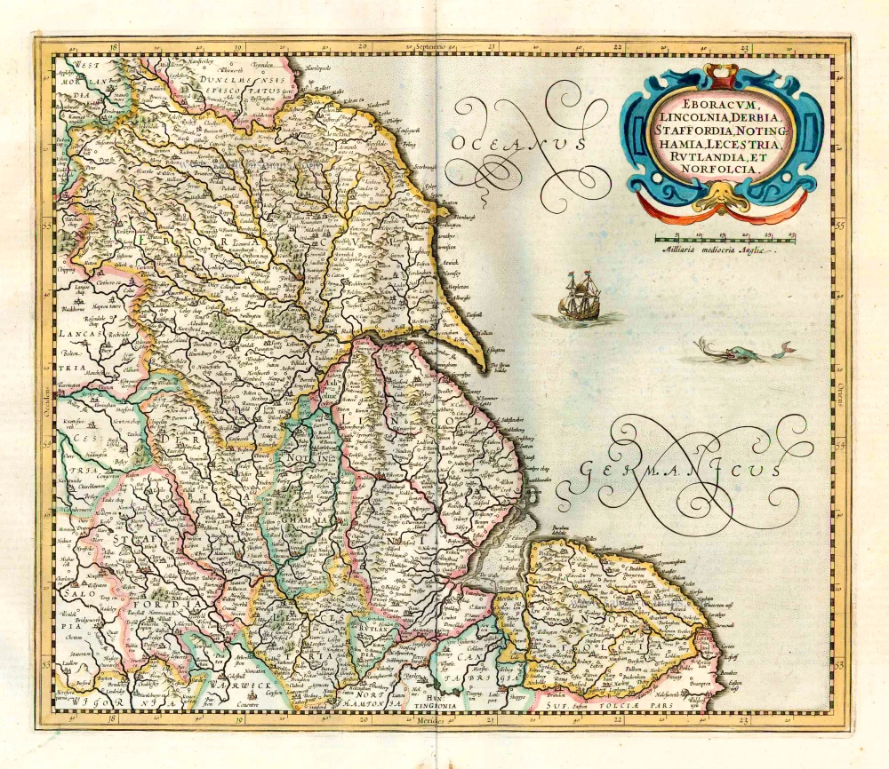
Eboracum, Lincolnia, Derbia, Statfordia, Notinghamia, Lecestria, Rutlandia et Norfolcia. 1641
Western England, by Henricus Hondius.
[Item number: 26247]
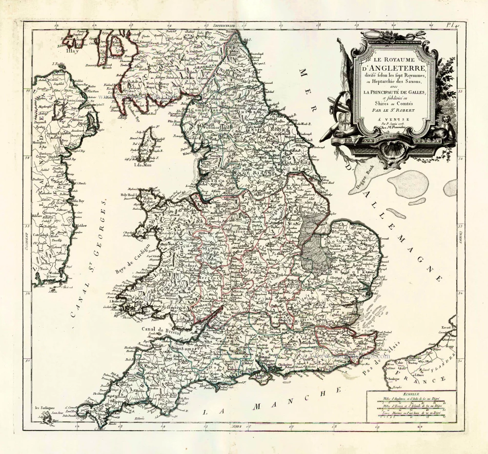
Le Royaume d'Angleterre, Divisé Selon les Sept Royaumes, ou Heptarchie des Saxons, avec la Principauté de Galles et Subdivisé en Shires ou Comtés. 1776-79
England, by Francesco Santini.
[Item number: 26960]
Anglia Regnum. 1623
England, by Gerard Mercator.
[Item number: 28132]

Orientalior Districtus Regni Angliae Comprehendens Comitatus et Provincias c. 1705
East England, by Frederick de Wit.
[Item number: 28990]

Tractus Regni Angliae Septentrion, in quo Ducatus Eboracensis, Episcopatus Dunelmensis, Comitatus Northumbriae, Cumbiae, Westmoriae, et Lancasstriae Cum Mona Insula. ca. 1691-93
Northern England, by Frederick de Wit.
[Item number: 29031]
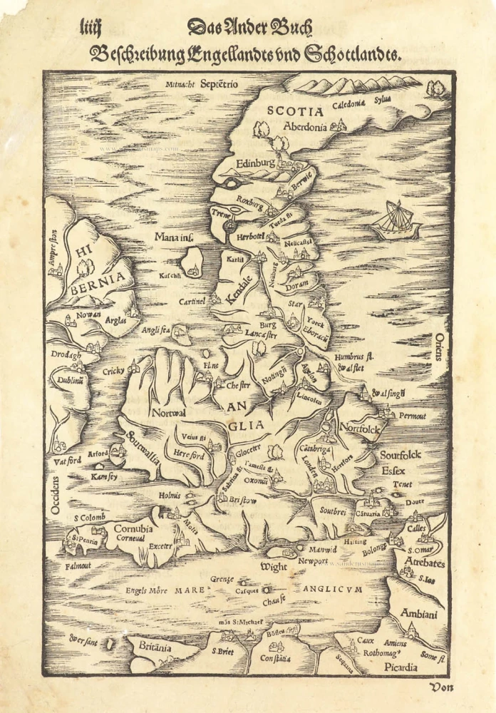
Beschreibung Engellandts und Schottlandts. 1578
Great Brittain by Sebastian Münster.
[Item number: 29468]

Anciens Royaumes de Mercie, et East-Angles ou sont les Comtés, ou Shiries de Chester, Darby, Nottingham, Lincolne, Rutland, Leicester, Stafford, Shrop-Sh, Hereford, Worcester, Warwick, Northampton, Huntington, Bedford, Buckingham, Oxford, et Glocester en Mercie Cambridge, Norfolk, et Suffolk en East-Angles. 1658
Central England by Nicolas Sanson.
[Item number: 29626]
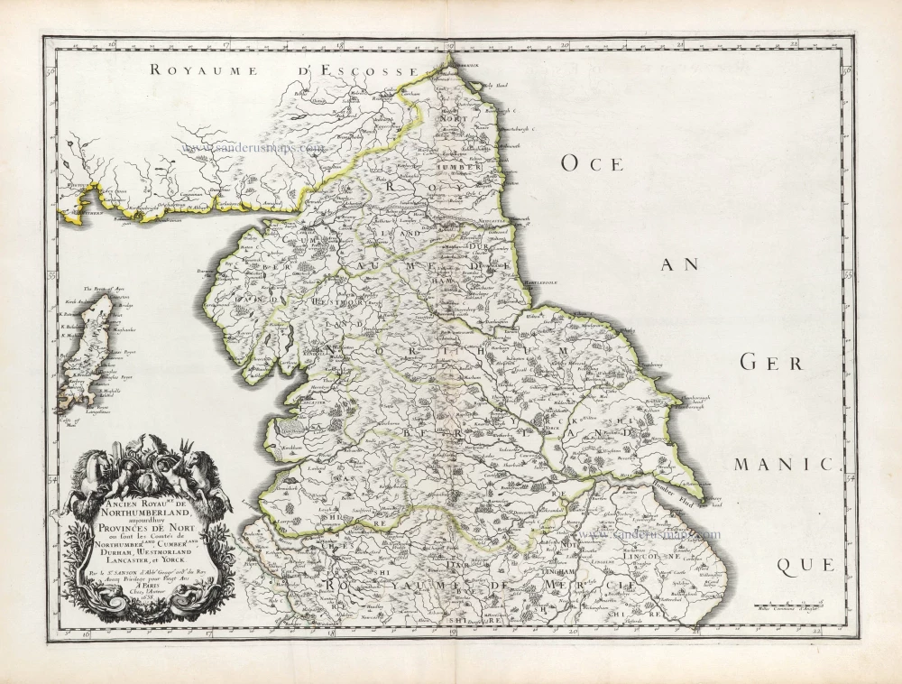
Ancien Royaume de Northumberland, aujourdhuy Provinces de Nort: ou sont les Comtés de Northumberland, Cimberland, Durham, Westmorland Lancaster, et Yorck. 1658
Northern England by Nicolas Sanson.
[Item number: 29666]