
Sea chart of the Channel by Gerard van Keulen. 1704

The House of Van Keulen
For more than two centuries, the chart makers firm of Van Keulen was established in the house with the name of “De Gekroonde Lootsman” (The Crowned Pilot). In 1678, the founder of the firm, Johannes I Van Keulen (1634-1689), registered with the Amsterdam booksellers’ guild. He had enlisted the aid of the well-known Mathematical Practitioner Claas Janz Vooght in the preparation of his nautical publications. In 1680 he published the first edition of the Zee-Atlas with 40 charts, all issued for the first time. In the short period of four years, they produced the five volumes of the Nieuwe Groote Ligtende Zee-Fakkel (1681-85). His acquisition of the stock of the bookseller Hendrik Doncker was an essential factor in the development of the firm.
In 1678 a son, Gerard Van Keulen (1678-1726), was born out of Johannes’s first marriage. This son was endowed with talent. He was a skilful engraver and proficient in mathematics and navigational science. Gerard was responsible for establishing the scientific basis of the firm of Van Keulen. In 1714 he was appointed to the office of hydrographer to the Dutch East India Company. The Van Keulens remained chart makers to the East India Company until the Company’s liquidation.
With the introductions to the Zee-Fakkel and Zee-Atlas, Gerard van Keulen gave a new impetus to the firm. Unfortunately, he did not live long, dying when he was 49. The business was carried on by his widow Ludwina Konst. Shortly before Gerard’s death, his son Johannes II had entered the bookseller’s guild, and in 1726 he assumed the management of the firm, though his mother retained her financial interests in the business.
Johannes II Van Keulen (1704-1755) is known in particular for his publication in 1753 of a sixth volume of the Zee-Fakkel, the volume containing the charts of the route to the East Indies.
Johannes II had two sons; they joined the firm as partners in 1757. A considerable number of books appeared in the period 1778-1801. New issues of the Zee-Fakkel again saw the light. The firm flourished under different names until 1885.
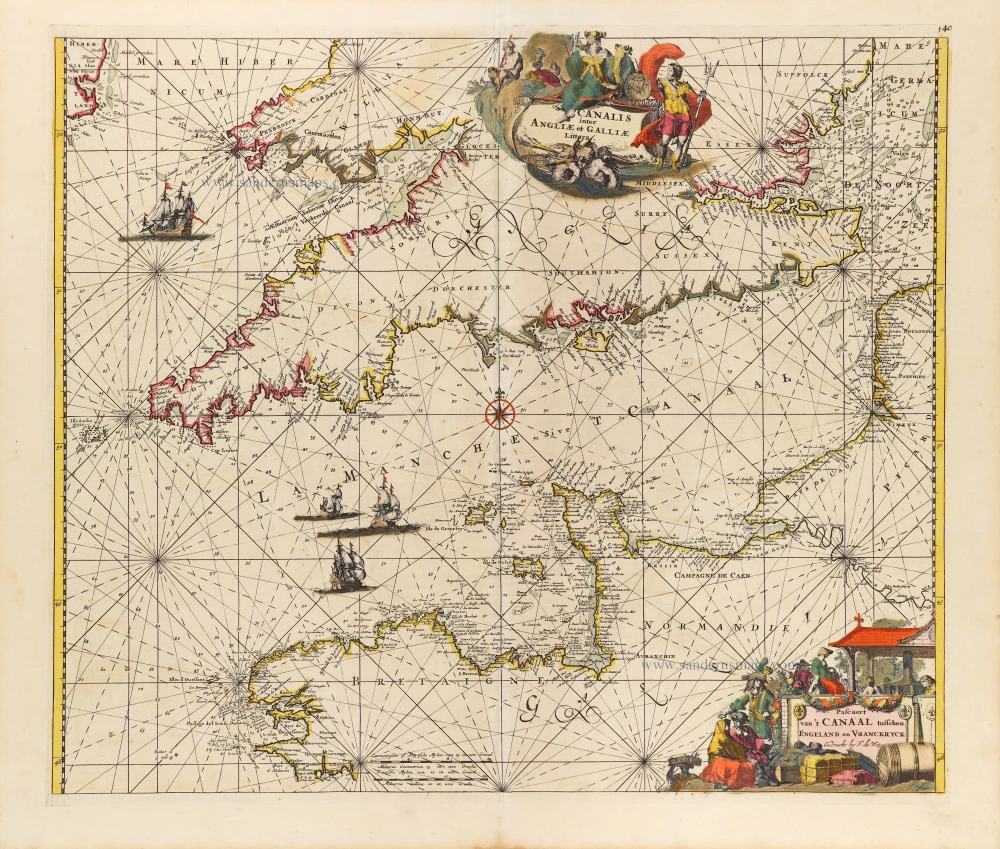
Nieuwe Zeekaart van t' Eerste Gedeelte van t' Canaal Tusschen Engeland en Vrankrijk. [Title also in French, English, Spanish, and Italian]
Item Number: 31427 Authenticity Guarantee
Category: Antique maps > Europe > British Isles
Sea chjrt of the Channel by Gerard van Keulen.
Title: Nieuwe Zeekaart van t' Eerste Gedeelte van t' Canaal Tusschen Engeland en Vrankrijk. [Title also in French, English, Spanish, and Italian]
t' Amsterdam By Ioannes van Keulen Boek-zeekaart verkooper en Graad-boog maker Aan de Oost-zyde vande Nieuw brugh inde Gekroonde Lootsman.
Opgestelt door Gerrard van Keulen Met Privilegie voor 15 Iaaren.
Oriented to the west.
Date of the first edition: 1704.
Date of this map: 1704.
Copper engraving, printed on paper.
Image size: 520 x 610mm (20½ x 24 inches).
Sheet size: 540 x 618mm (21¼ x 24¼ inches).
Verso: Blank.
Condition: Original coloured, short left margin.
Condition Rating: A+.
From: De Nieuwe Groote Ligtende Zee-Fakkel, ... Door Gerard van Keulen. Amsterdam, J. Van Keulen, 1704. (Koeman IV, Keu64)
The House of Van Keulen
For more than two centuries, the chart makers firm of Van Keulen was established in the house with the name of “De Gekroonde Lootsman” (The Crowned Pilot). In 1678, the founder of the firm, Johannes I Van Keulen (1634-1689), registered with the Amsterdam booksellers’ guild. He had enlisted the aid of the well-known Mathematical Practitioner Claas Janz Vooght in the preparation of his nautical publications. In 1680 he published the first edition of the Zee-Atlas with 40 charts, all issued for the first time. In the short period of four years, they produced the five volumes of the Nieuwe Groote Ligtende Zee-Fakkel (1681-85). His acquisition of the stock of the bookseller Hendrik Doncker was an essential factor in the development of the firm.
In 1678 a son, Gerard Van Keulen (1678-1726), was born out of Johannes’s first marriage. This son was endowed with talent. He was a skilful engraver and proficient in mathematics and navigational science. Gerard was responsible for establishing the scientific basis of the firm of Van Keulen. In 1714 he was appointed to the office of hydrographer to the Dutch East India Company. The Van Keulens remained chart makers to the East India Company until the Company’s liquidation.
With the introductions to the Zee-Fakkel and Zee-Atlas, Gerard van Keulen gave a new impetus to the firm. Unfortunately, he did not live long, dying when he was 49. The business was carried on by his widow Ludwina Konst. Shortly before Gerard’s death, his son Johannes II had entered the bookseller’s guild, and in 1726 he assumed the management of the firm, though his mother retained her financial interests in the business.
Johannes II Van Keulen (1704-1755) is known in particular for his publication in 1753 of a sixth volume of the Zee-Fakkel, the volume containing the charts of the route to the East Indies.
Johannes II had two sons; they joined the firm as partners in 1757. A considerable number of books appeared in the period 1778-1801. New issues of the Zee-Fakkel again saw the light. The firm flourished under different names until 1885.
Related items

Pas-kaert vande Canael, Tusschen Engelandt en Vrancryck Beginnende van C. de la Hague tot Heyssant, als mede van Poortland tot Lezard. 1697-1709
Bretagne and the Channel, by Van Keulen Johannes.
[Item number: 5406]

Sea chart
Pascaert van de Canael Tusschen Engelandt en Vrancryck, van Cales tot C. de la Hague, als meede van Doever tot Poortlant ... 1697-1709
Normandy by Van Keulen Johannes.
[Item number: 13639]

Anglesey [on sheet with] Wight ol. Vectis [and] Garnesay [and] Iarsay 1607
Anglesey, Wight & Channel Islands, by Gerard Mercator.
[Item number: 13705]

Pas-Caert van de Canael, tusschen Engelandt en Vranckryck, van Pleymuyen tot aen de Sorlinges ... 1697-1709
The Channel, by Van Keulen Johannes.
[Item number: 14588]

Sarnia Insula, vulgo Garnsey: et Insula Caesarae, vernacule Jarsey 1645-48
The Channel Islands, by J. Blaeu.
[Item number: 24640]

Spectacular 'Romain de Hooghe' map
Carte Nouvelle des Costes de Hollande, Zeelande, Flandre, Picardie, & Normandie ... Chez Pierre Mortier, 1693. 1700
Sea chart of the Channel - Flanders (Vlaanderen) - Zeeland, by Pieter Mortier.
[Item number: 27176]

Carte de la Manche. c. 1705
Channel, by Pierre Mortier.
[Item number: 28001]
Canalis inter Angliae et Galliae Littera. - Pascaert van 't Canaal tusschen Engeland en Vranckryck. c. 1680
The English Channel, by Frederick de Wit.
[Item number: 29171]

Carte de la Manche. 1692
Channel by N. Sanson, so-called published by Hubert Jaillot. (Pirated edition by Pierre Mortier).
[Item number: 31172]

Carte Réduite des Isles Britanniques en cinq feuilles Pour servir aux vaisseaux du Roy. 1765
Sea chart of the Channel - between France and England & Wales, by Jacques Nicolas Bellin.
[Item number: 31445]