
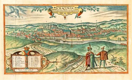
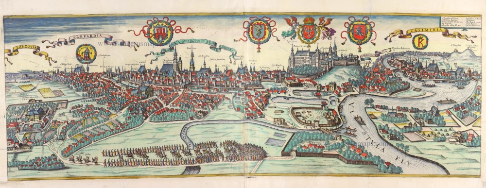
Krakow, by Georg Braun and Frans Hogenberg. after G. Hoefnagel and E. vander Rye. 1617-18
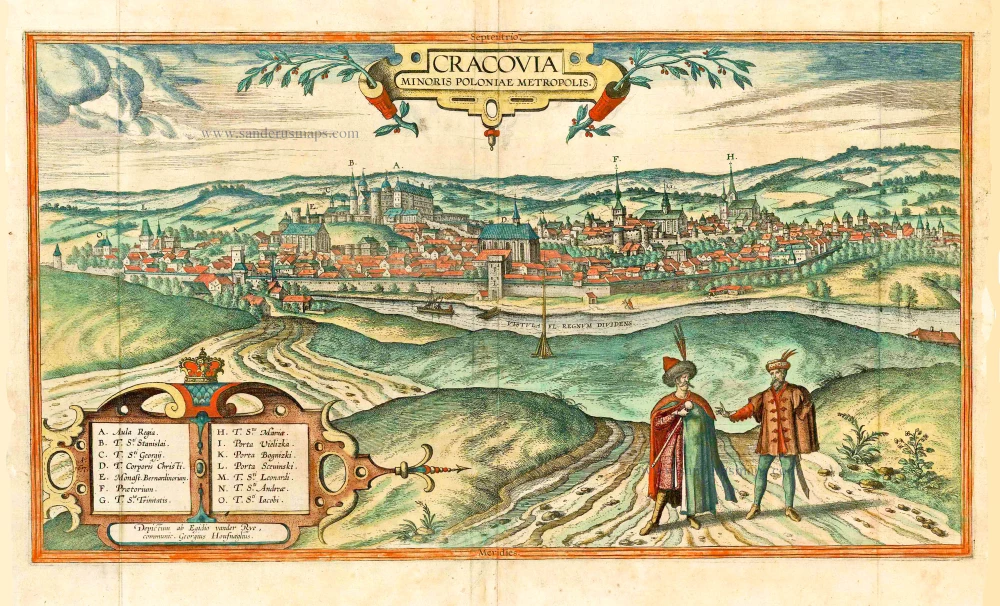

CARTOUCHE TOP: Cracow, capital of Lesser Poland.
CARTOUCHE BOTTOM: Painted by Egidius van der Rye, procured by Georg Hoefnagel.
COMMENTARY BY BRAUN (on verso): "Cracow has a very big marketplace on which stands a splendid town hall. Here justice is administered and important official acts are performed. \[...\] But the castle is so big that it can be considered a town in its own right. It is surrounded by such splendid buildings and palaces that even the finest castles and houses in Italy could be more beautiful or more magnificent. \[...\] But because the dukes and kings understood that to preserve the Christian religion it is also necessary to cultivate equally the good liberal arts and sciences and to promote diligence to the greatest possible extent, Casimir III set up a university in his city of Cracow, which was named after him in 1361, with the approval of Pope Urban V, and appointed scholars from Paris and Prague."
This is a view of the city from the south over the River Vistula. On Wawel hill lies the royal castle (A) with the cathedral dedicated to SS Wenceslas and Stanislas (B). In the middle rises the church of Corpus Christi (D); to the right of this are the town hall (F), the church of the Holy Trinity (G) and the church of St Mary (H). First mentioned in 965, the town became part of the Piast state unde Mieszko I. In 1038 Duke Casimir I, the Restorer, made Cracow the capital of Poland, and the first university in the country was founded here in 1364 by King Casimir III of Poland, called the Great. The city's Golden Age was during the reign of the Jagiellon kings from 1506 to 1572, when many Renaissance buildings were erected, which still adorn the city. (Taschen)
Braun G. & Hogenberg F. and the Civitates Orbis Terrarum.
The Civitates Orbis Terrarum, also known as the 'Braun & Hogenberg', is a six-volume town atlas and the most excellent book of town views and plans ever published: 363 engravings, sometimes beautifully coloured. It was one of the best-selling works in the last quarter of the 16th century. Georg Braun, a skilled writer, wrote the text accompanying the plans and views on the verso. Many plates were engraved after the original drawings of a professional artist, Joris Hoefnagel (1542-1600). The first volume was published in Latin in 1572 and the sixth in 1617. Frans Hogenberg, a talented engraver, created the tables for volumes I through IV, and Simon van den Neuwel made those for volumes V and VI. Other contributors were cartographers Daniel Freese and Heinrich Rantzau, who provided valuable geographical information. Works by Jacob van Deventer, Sebastian Münster, and Johannes Stumpf were also used as references. Translations appeared in German and French, making the atlas accessible to a wider audience.
Since its original publication of volume 1 in 1572, the Civitates Orbis Terrarum has left an indelible mark on the history of cartography. The first volume was followed by seven more editions in 1575, 1577, 1582, 1588, 1593, 1599, and 1612. Vol.2, initially released in 1575, saw subsequent editions in 1597 and 1612. The subsequent volumes, each a treasure trove of historical insights, graced the world in 1581, 1588, 1593, 1599, and 1606. The German translation of the first volume, a testament to its widespread appeal, debuted in 1574, followed by the French edition in 1575.
Several printers were involved: Theodor Graminaeus, Heinrich von Aich, Gottfried von Kempen, Johannis Sinniger, Bertram Buchholtz, and Peter von Brachel, all of whom worked in Cologne.
Georg Braun (1541-1622)
Georg Braun, the author of the text accompanying the plans and views in the Civitates Orbis Terrarum, was born in Cologne in 1541. After his studies in Cologne, he entered the Jesuit Order as a novice, indicating his commitment to learning and intellectual pursuits. In 1561, he obtained his bachelor's degree; in 1562, he received his Magister Artium, further demonstrating his academic achievements. Although he left the Jesuit Order, he continued his studies in theology, gaining a licentiate in theology. His theological background likely influenced the content and tone of the text in the Civitates Orbis Terrarum, adding a unique perspective to the work.
Frans Hogenberg (1535-1590)
Frans Hogenberg was a Flemish and German painter, engraver, and mapmaker. He was born in Mechelen as the son of Nicolaas Hogenberg.
By the end of the 1560s, Frans Hogenberg was employed upon Abraham Ortelius's Theatrum Orbis Terrarum, published in 1570; he is named an engraver of numerous maps. In 1568, he was banned from Antwerp by the Duke of Alva and travelled to London, where he stayed a few years before emigrating to Cologne. He immediately embarked on his two most important works, the Civitates, published in 1572 and the Geschichtsblätter, which appeared in several series from 1569 until about 1587.
Thanks to large-scale projects like the Geschichtsblätter and the Civitates, Hogenberg's social circumstances improved with each passing year. He died as a wealthy man in Cologne in 1590.
Cracovia Minoris Poloniae Metropolis.
Item Number: 25150 Authenticity Guarantee
Category: Antique maps > Europe > Eastern Europe
Old map - bird's-eye view of Krakow by Georg Braun and Frans Hogenberg after Joris Hoefnagel and Egidius vander Rye.
Date of the first edition: 1617
Date of this map: 1617
Copper engraving, printed on paper.
Size (not including margins): 30.5 x 53cm (11.9 x 20.7 inches)
Verso text: Latin
Condition: Original coloured, excellent.
Condition Rating: A+
References: Van der Krogt 4, 2152; Fauser, #6965; Taschen, Br. Hog.,, p.479; Niewodniczanski, K103/1.
From: Civitates Orbis Terrarum. - Theatri praecipuarum Totius Mundi Urbium Liber Sextus Anno MDCXVII. Cologne, Anton Hierat, 1617-18. (Van der Krogt 4, 41:1.6)
CARTOUCHE TOP: Cracow, capital of Lesser Poland.
CARTOUCHE BOTTOM: Painted by Egidius van der Rye, procured by Georg Hoefnagel.
COMMENTARY BY BRAUN (on verso): "Cracow has a very big marketplace on which stands a splendid town hall. Here justice is administered and important official acts are performed. \[...\] But the castle is so big that it can be considered a town in its own right. It is surrounded by such splendid buildings and palaces that even the finest castles and houses in Italy could be more beautiful or more magnificent. \[...\] But because the dukes and kings understood that to preserve the Christian religion it is also necessary to cultivate equally the good liberal arts and sciences and to promote diligence to the greatest possible extent, Casimir III set up a university in his city of Cracow, which was named after him in 1361, with the approval of Pope Urban V, and appointed scholars from Paris and Prague."
This is a view of the city from the south over the River Vistula. On Wawel hill lies the royal castle (A) with the cathedral dedicated to SS Wenceslas and Stanislas (B). In the middle rises the church of Corpus Christi (D); to the right of this are the town hall (F), the church of the Holy Trinity (G) and the church of St Mary (H). First mentioned in 965, the town became part of the Piast state unde Mieszko I. In 1038 Duke Casimir I, the Restorer, made Cracow the capital of Poland, and the first university in the country was founded here in 1364 by King Casimir III of Poland, called the Great. The city's Golden Age was during the reign of the Jagiellon kings from 1506 to 1572, when many Renaissance buildings were erected, which still adorn the city. (Taschen)
Braun G. & Hogenberg F. and the Civitates Orbis Terrarum.
The Civitates Orbis Terrarum, also known as the 'Braun & Hogenberg', is a six-volume town atlas and the most excellent book of town views and plans ever published: 363 engravings, sometimes beautifully coloured. It was one of the best-selling works in the last quarter of the 16th century. Georg Braun, a skilled writer, wrote the text accompanying the plans and views on the verso. Many plates were engraved after the original drawings of a professional artist, Joris Hoefnagel (1542-1600). The first volume was published in Latin in 1572 and the sixth in 1617. Frans Hogenberg, a talented engraver, created the tables for volumes I through IV, and Simon van den Neuwel made those for volumes V and VI. Other contributors were cartographers Daniel Freese and Heinrich Rantzau, who provided valuable geographical information. Works by Jacob van Deventer, Sebastian Münster, and Johannes Stumpf were also used as references. Translations appeared in German and French, making the atlas accessible to a wider audience.
Since its original publication of volume 1 in 1572, the Civitates Orbis Terrarum has left an indelible mark on the history of cartography. The first volume was followed by seven more editions in 1575, 1577, 1582, 1588, 1593, 1599, and 1612. Vol.2, initially released in 1575, saw subsequent editions in 1597 and 1612. The subsequent volumes, each a treasure trove of historical insights, graced the world in 1581, 1588, 1593, 1599, and 1606. The German translation of the first volume, a testament to its widespread appeal, debuted in 1574, followed by the French edition in 1575.
Several printers were involved: Theodor Graminaeus, Heinrich von Aich, Gottfried von Kempen, Johannis Sinniger, Bertram Buchholtz, and Peter von Brachel, all of whom worked in Cologne.
Georg Braun (1541-1622)
Georg Braun, the author of the text accompanying the plans and views in the Civitates Orbis Terrarum, was born in Cologne in 1541. After his studies in Cologne, he entered the Jesuit Order as a novice, indicating his commitment to learning and intellectual pursuits. In 1561, he obtained his bachelor's degree; in 1562, he received his Magister Artium, further demonstrating his academic achievements. Although he left the Jesuit Order, he continued his studies in theology, gaining a licentiate in theology. His theological background likely influenced the content and tone of the text in the Civitates Orbis Terrarum, adding a unique perspective to the work.
Frans Hogenberg (1535-1590)
Frans Hogenberg was a Flemish and German painter, engraver, and mapmaker. He was born in Mechelen as the son of Nicolaas Hogenberg.
By the end of the 1560s, Frans Hogenberg was employed upon Abraham Ortelius's Theatrum Orbis Terrarum, published in 1570; he is named an engraver of numerous maps. In 1568, he was banned from Antwerp by the Duke of Alva and travelled to London, where he stayed a few years before emigrating to Cologne. He immediately embarked on his two most important works, the Civitates, published in 1572 and the Geschichtsblätter, which appeared in several series from 1569 until about 1587.
Thanks to large-scale projects like the Geschichtsblätter and the Civitates, Hogenberg's social circumstances improved with each passing year. He died as a wealthy man in Cologne in 1590.
Related items
Dantzigk - Gedanum, Krantio, in sua Wandalia Gdanum; . . . 1576
Gdansk, by Georg Braun and Frans Hogenberg.
[Item number: 4056]
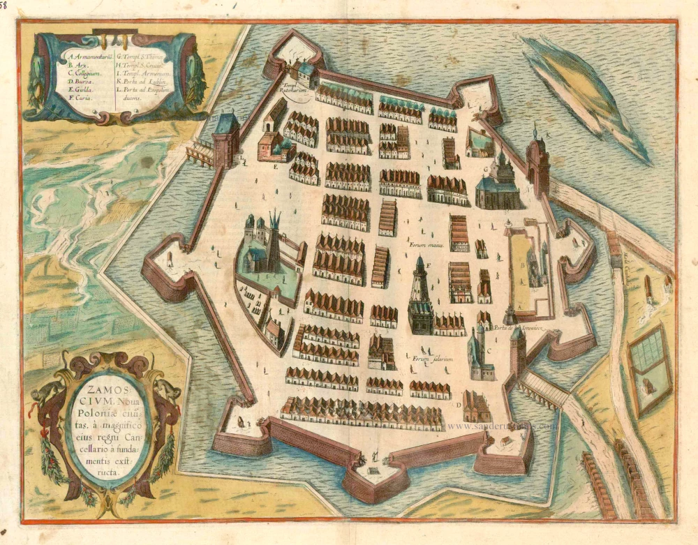
Zamoscium. Nova Poloniae civitas, à magnifico eius regni Cancellaro à fundamentis exstructa. c. 1625
Zamosc in Poland, by Georg Braun and Frans Hogenberg.
[Item number: 16505]
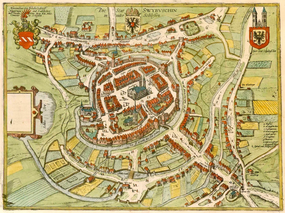
Die Stat Swybuschin in Nider Schlesien. 1596
Poland - Swiebodzin, by Braun & Hogenberg.
[Item number: 22102]
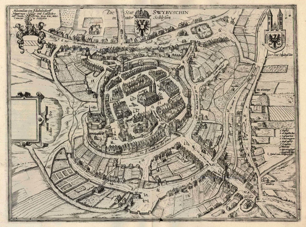
Die Stat Swybuschin in Nider Schlesien 1596
Swiebodzin, by Georg Braun and Frans Hogenberg.
[Item number: 24182]
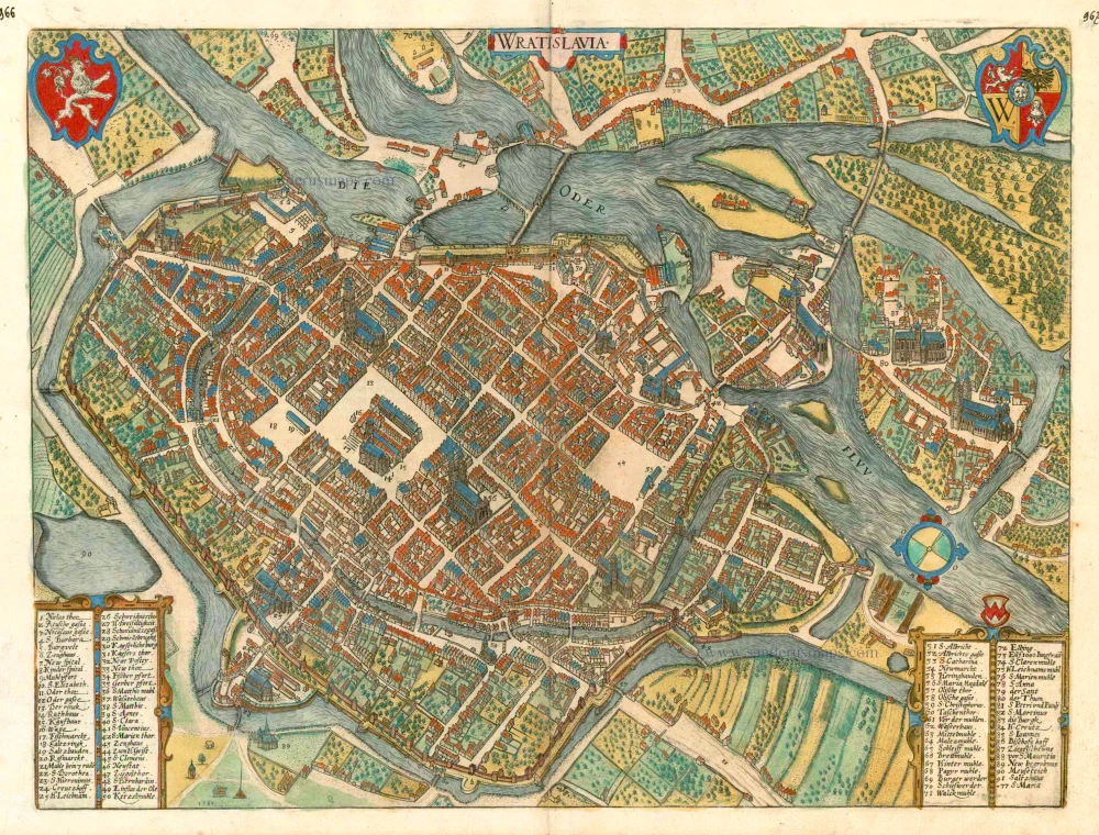
Wratislavia. c. 1593
Wroclaw (Breslau), by Georg Braun and Frans Hogenberg.
[Item number: 24572]
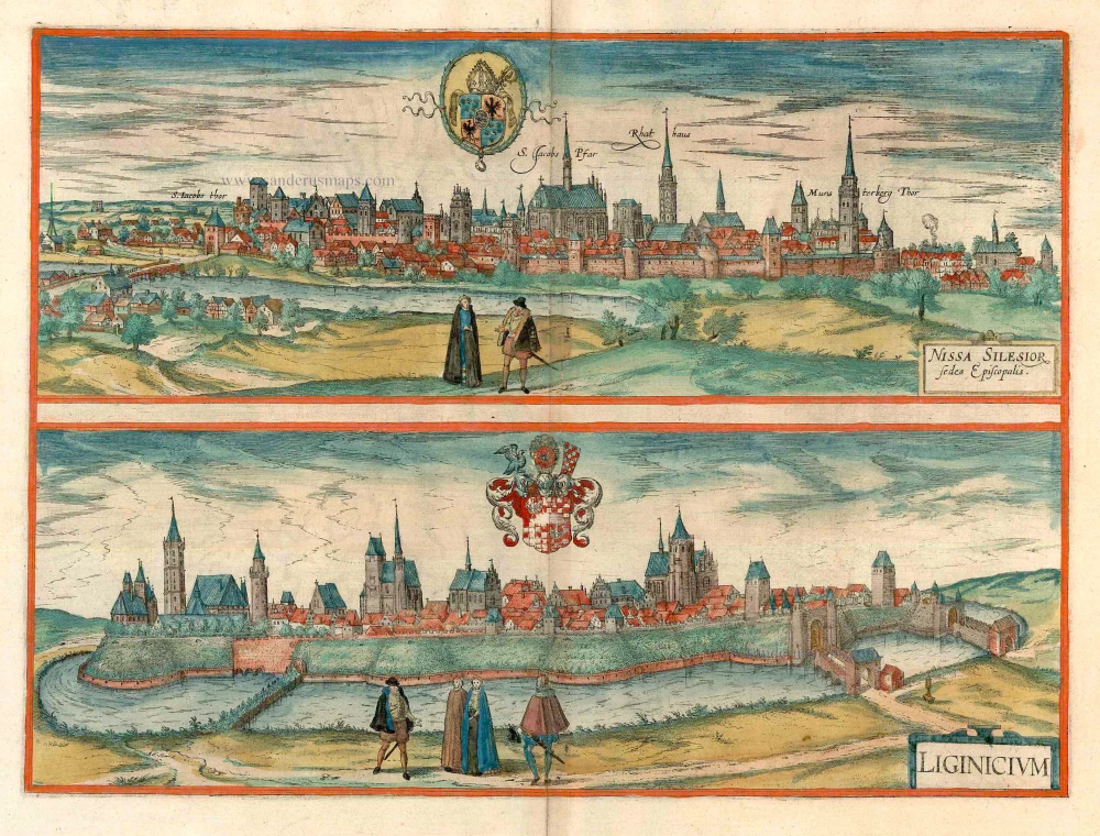
Nissa Silesior Sedes Episcopalis [on sheet with] Liginicium c. 1625
Nysa and Legnica (Poland), by Georg Braun and Frans Hogenberg.
[Item number: 24584]
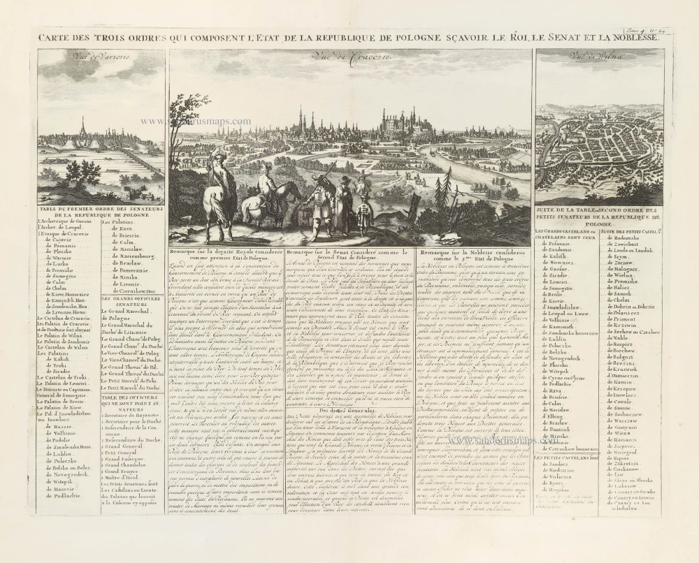
Carte des trois ordres qui composent l'Etat de la République de Pologne sçavoir le Roi, le Senat et la Noblesse. 1714
Krakow, Warsaw, and Vilnius, by Zacharias Châtelain.
[Item number: 29411]
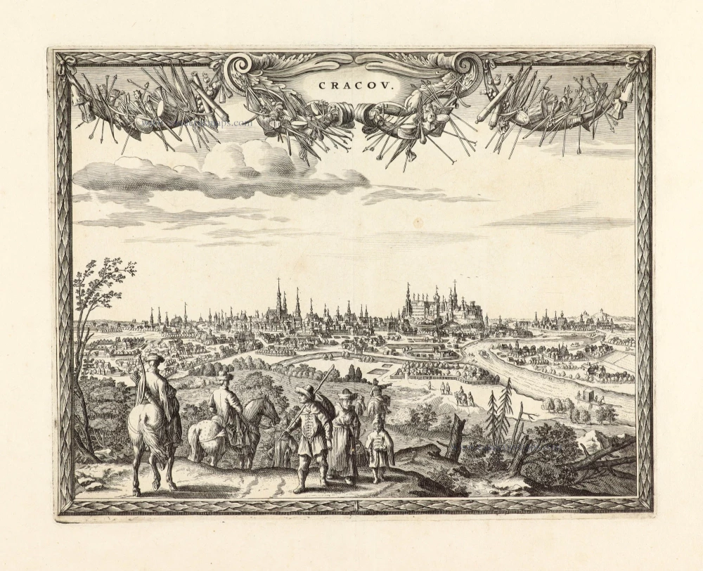
Unrecorded variant of Carel Allard's view of Krakow
Cracov. 1673
View of Krakow by Carel Allard.
[Item number: 30552]
Cracovia Metropolis Regni Poloniae - Lobzovia - Clepardia - Casimiria. 1617-18
Cracow and surroundings, by Georg Braun and Frans Hogenberg.
[Item number: 30624]
new