
Bellarus and parts of Lithuania and Ukraine, by Francesco Santini. 1776-79

Francesco and Paolo Santini (c.1729-1793)
Francesco Santini, a Venetian publisher, acquired the printing plates of Vaugondy’s Atlas Universel …, a commercial and cartographic success, with widespread influence on mapmakers throughout Europe. Together with his brother Paolo, he commissioned a new set of plates and reissued the atlas in 1776. The following year, Paolo Santini assigned all his publication rights to M. Remondini, who in 1777 reissued the same atlas but with his name.
Carte de la Lithuanie Russienne qui Comprend les Palatinats de Livonie, de Witepsk, de Miscislaw, et une Partie de ceux de Polock et de Minsk Cédés par la Pologne a la Russie.
Item Number: 26969 Authenticity Guarantee
Category: Antique maps > Europe > Eastern Europe
Old, antique map of Bellarus and parts of Lithuania and Ukraine, by Francesco Santini.
Cartographer: Homann Heirs
First state with the imprint of Remondini: with engraved page numbers in the top right corner: "P.I.50".
Date of the first edition: 1776
Date of this map: 1776
Copper engraving, printed on paper.
Size (not including margins): 55 x 44.5cm (21.5 x 17.4 inches)
Verso: Blank
Condition: Original coloured in outline, excellent.
Condition Rating: A+
From: Atlas Universel dressé sur les meilleures cartes modernes. Venice, Remondini, 1776.
Francesco and Paolo Santini (c.1729-1793)
Francesco Santini, a Venetian publisher, acquired the printing plates of Vaugondy’s Atlas Universel …, a commercial and cartographic success, with widespread influence on mapmakers throughout Europe. Together with his brother Paolo, he commissioned a new set of plates and reissued the atlas in 1776. The following year, Paolo Santini assigned all his publication rights to M. Remondini, who in 1777 reissued the same atlas but with his name.
Related items

La Pologne Dressée sur ce qu'en ont donné Starovolsk, Beauplan, Hartnoch, et autres auteurs. [Latin title in upper margin:] Tabula Regni Poloniae, Ducatus Lithuaniae &c. 1730
Poland - Lithuania by Guillaume Delisle, published by Covens & Mortier.
[Item number: 25890]

Taurica Chersonesus VS. nostra Aetate Przecopsca et Gazara Dicitur. 1641
Ukraine - Crimea by Henricus Hondius.
[Item number: 26264]

Cimmeria quae Postea Scythia Europaea Seu Parua Scythia. 1665
Ukraine, by Nicolas Sanson.
[Item number: 27919]
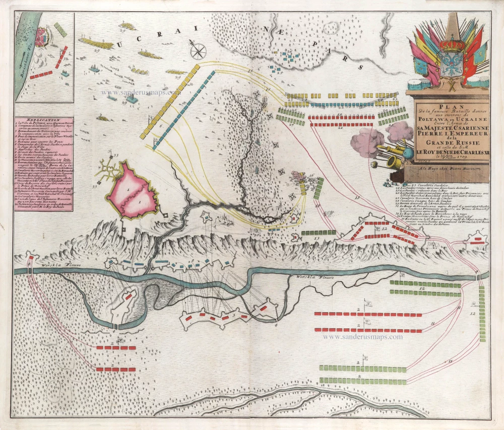
Plan de la fameuse Bataille donnee aux environs de Poltawa en Ucraine Entre l'Armee de sa Majesté Csarienne Pierre I. Empereur de la Grande Russie et celle de S.M. le Roy de Suede Charles XII. me 27 Juin -8 Jullet 1709. c. 1709
Map of the Battle of Poltawa (Ukraine) in 1709, by Pierre Husson.
[Item number: 29587]
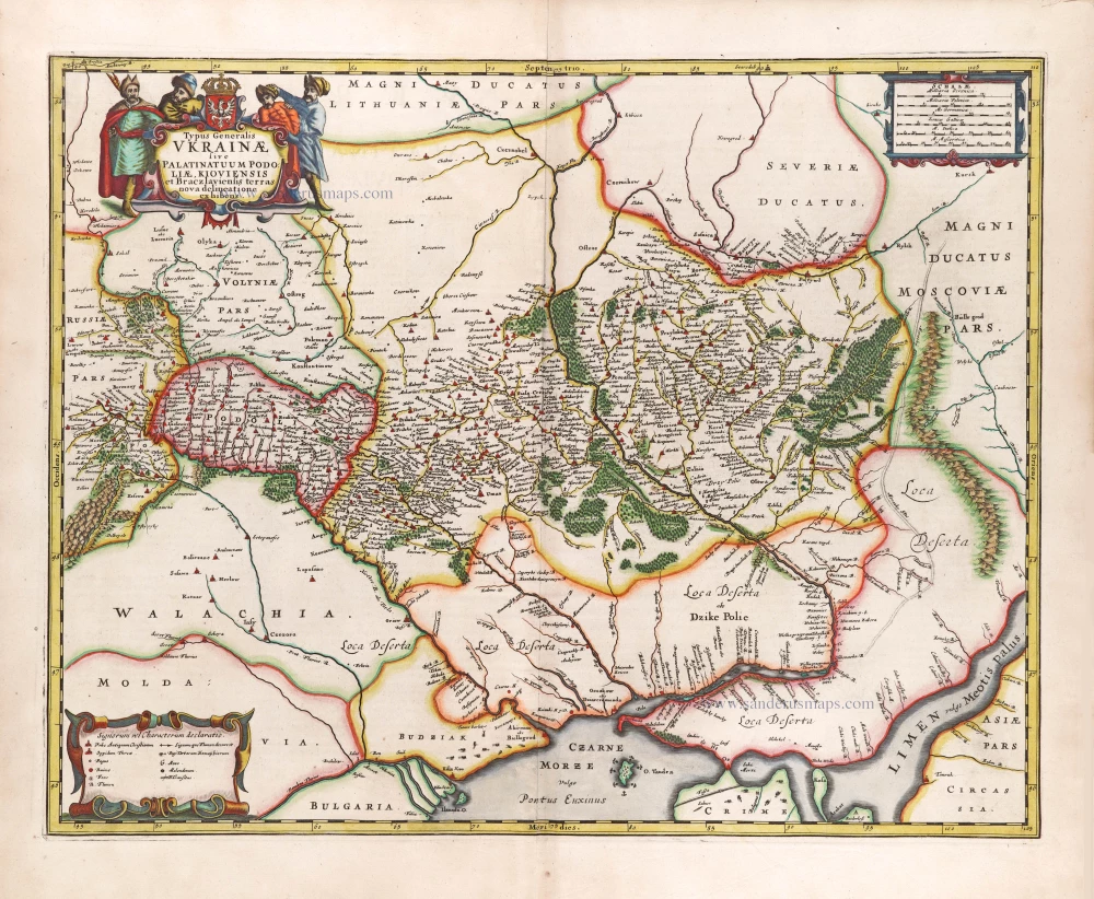
Typus Generalis Ukrainae sive Palatinatuum Podoliae, Kioviensis et Braczlaviensis Terras Nova Delineatione Exhibens. 1666
Ukraine, by Johannes Janssonius.
[Item number: 29957]

[Title on verso:] Tabula .VIII. Europae. 1525
Ptolemy map of Eastern Europe, Ukraine - Russia by Lorenz Fries, after Martin Waldseemüller.
[Item number: 30369]
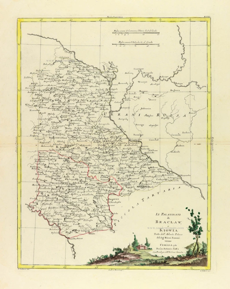
Li Palatinati di Braclaw, e Kiowia. 1779-1785
Ukraine, by Antonio Zatta.
[Item number: 32134]

Li Palatinati di Wilna, Troji, Inflant, coi Ducati di Kurlandia, e Smuz. 1779-1785
Lithuania - Latvia, by Antonio Zatta.
[Item number: 32135]

Ducatuum Livoniae et Curlandiae cum vicinis Insulis c. 1720
Livonia & Curlandia (Latvia), by J.B. Homann.
[Item number: 32273]