
Vilnius, by Georg Braun & Frans Hogenberg. 1581
The item displayed on this page has been sold. However, we have a similar map in stock:
Vilnius, by Georg Braun & Frans Hogenberg. 1583
Vilna Lituaniae Metropolis.
[Item number: 30622]
new

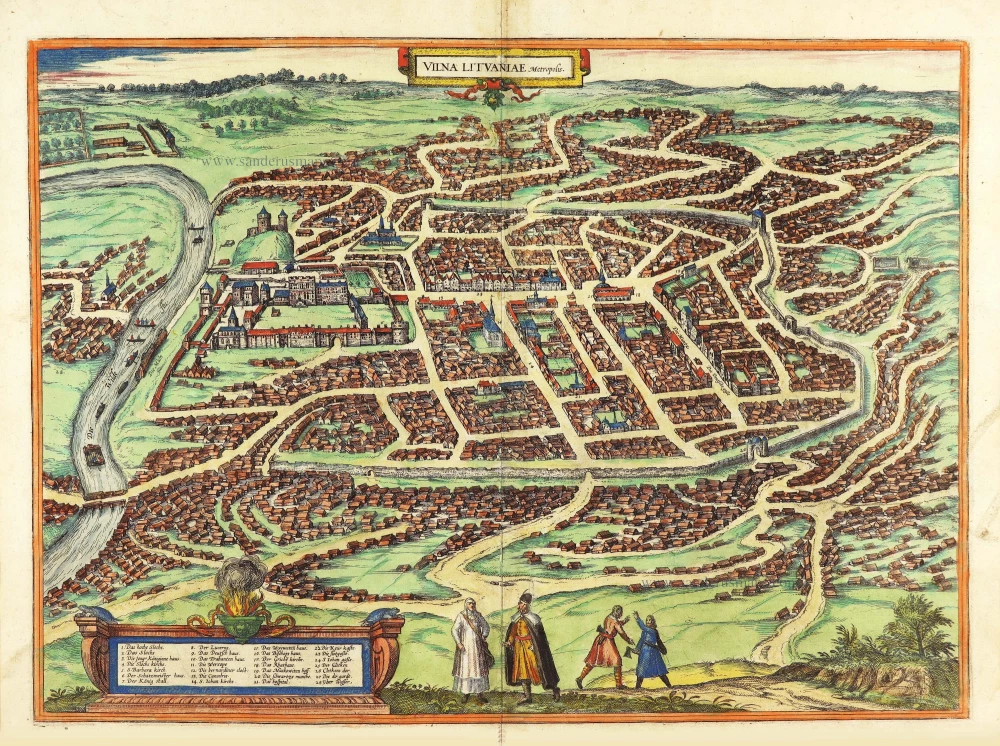


CARTOUCHE: Vilnius, capital of Lithuania.
COMMENTARY BY BRAUN: "Vilnius is a large, densely populated episcopal city in the Duchy of Lithuania. The city is enclosed within a wall and gates, which are no longer sufficient; all the houses in it are made of wood, very low, and altogether very plain except for certain streets in which foreign merchants have erected handsome houses made of stone. There are two royal palaces, one very spacious and famous for its halls. The other palace is on a hill, and one can see very far from its towers. Here there is also a magnificent monastery dedicated to St Bernard."
This is a bird's-eye view of Vilnius. The rows of houses are sketched very simply. Starting in the 15th century, Vilnius experienced a period of prosperity, ending in the 16th century when the city came under Polish influence (1569). In 1570, during the Counter-Reformation, a Jesuit college was established that was expanded into a university in 1579 by the Polish king Stephen Bathory. The Upper Castle of Gediminas, on the hill of the same name that can be seen on the left beside the River Neris, has been preserved as a ruin and is the city's landmark; other buildings that stand out in the sea of houses include the late Gothic brick building of the church of St John (14) and the monastery of St Bernard (12). The town hall (18) was destroyed by armed conflict; today's Neoclassical building dates from the 18th century and houses the city's art museum. Vilnius is today the capital of Lithuania. (Taschen)
Braun G. & Hogenberg F. and the Civitates Orbis Terrarum.
The Civitates Orbis Terrarum, also known as the 'Braun & Hogenberg', is a six-volume town atlas and the most excellent book of town views and plans ever published: 363 engravings, sometimes beautifully coloured. It was one of the best-selling works in the last quarter of the 16th century. Georg Braun, a skilled writer, wrote the text accompanying the plans and views on the verso. Many plates were engraved after the original drawings of a professional artist, Joris Hoefnagel (1542-1600). The first volume was published in Latin in 1572 and the sixth in 1617. Frans Hogenberg, a talented engraver, created the tables for volumes I through IV, and Simon van den Neuwel made those for volumes V and VI. Other contributors were cartographers Daniel Freese and Heinrich Rantzau, who provided valuable geographical information. Works by Jacob van Deventer, Sebastian Münster, and Johannes Stumpf were also used as references. Translations appeared in German and French, making the atlas accessible to a wider audience.
Since its original publication of volume 1 in 1572, the Civitates Orbis Terrarum has left an indelible mark on the history of cartography. The first volume was followed by seven more editions in 1575, 1577, 1582, 1588, 1593, 1599, and 1612. Vol.2, initially released in 1575, saw subsequent editions in 1597 and 1612. The subsequent volumes, each a treasure trove of historical insights, graced the world in 1581, 1588, 1593, 1599, and 1606. The German translation of the first volume, a testament to its widespread appeal, debuted in 1574, followed by the French edition in 1575.
Several printers were involved: Theodor Graminaeus, Heinrich von Aich, Gottfried von Kempen, Johannis Sinniger, Bertram Buchholtz, and Peter von Brachel, all of whom worked in Cologne.
Georg Braun (1541-1622)
Georg Braun, the author of the text accompanying the plans and views in the Civitates Orbis Terrarum, was born in Cologne in 1541. After his studies in Cologne, he entered the Jesuit Order as a novice, indicating his commitment to learning and intellectual pursuits. In 1561, he obtained his bachelor's degree; in 1562, he received his Magister Artium, further demonstrating his academic achievements. Although he left the Jesuit Order, he continued his studies in theology, gaining a licentiate in theology. His theological background likely influenced the content and tone of the text in the Civitates Orbis Terrarum, adding a unique perspective to the work.
Frans Hogenberg (1535-1590)
Frans Hogenberg was a Flemish and German painter, engraver, and mapmaker. He was born in Mechelen as the son of Nicolaas Hogenberg.
By the end of the 1560s, Frans Hogenberg was employed upon Abraham Ortelius's Theatrum Orbis Terrarum, published in 1570; he is named an engraver of numerous maps. In 1568, he was banned from Antwerp by the Duke of Alva and travelled to London, where he stayed a few years before emigrating to Cologne. He immediately embarked on his two most important works, the Civitates, published in 1572 and the Geschichtsblätter, which appeared in several series from 1569 until about 1587.
Thanks to large-scale projects like the Geschichtsblätter and the Civitates, Hogenberg's social circumstances improved with each passing year. He died as a wealthy man in Cologne in 1590.
Vilna Lituaniae Metropolis.
Item Number: 29163 Authenticity Guarantee
Category: Antique maps > Europe > Eastern Europe
Old, antique bird’s-eye view plan of Vilnius, by Georg Braun & Frans Hogenberg.
Title: Vilna Lituaniae Metropolis.
Date of the first edition: 1581.
Date of this map: 1581.
Copper engraving, printed on paper.
Size (not including margins): 370 x 505mm (14.57 x 19.88 inches).
Verso: Latin text.
Condition: Original coloured, excellent.
Condition Rating: A+.
From: Civitates Orbis Terrarum. . Liber tertius. Cologne, Gottfried von Kempen, 1581. (Van der Krogt 4, 41:1.3)
CARTOUCHE: Vilnius, capital of Lithuania.
COMMENTARY BY BRAUN: "Vilnius is a large, densely populated episcopal city in the Duchy of Lithuania. The city is enclosed within a wall and gates, which are no longer sufficient; all the houses in it are made of wood, very low, and altogether very plain except for certain streets in which foreign merchants have erected handsome houses made of stone. There are two royal palaces, one very spacious and famous for its halls. The other palace is on a hill, and one can see very far from its towers. Here there is also a magnificent monastery dedicated to St Bernard."
This is a bird's-eye view of Vilnius. The rows of houses are sketched very simply. Starting in the 15th century, Vilnius experienced a period of prosperity, ending in the 16th century when the city came under Polish influence (1569). In 1570, during the Counter-Reformation, a Jesuit college was established that was expanded into a university in 1579 by the Polish king Stephen Bathory. The Upper Castle of Gediminas, on the hill of the same name that can be seen on the left beside the River Neris, has been preserved as a ruin and is the city's landmark; other buildings that stand out in the sea of houses include the late Gothic brick building of the church of St John (14) and the monastery of St Bernard (12). The town hall (18) was destroyed by armed conflict; today's Neoclassical building dates from the 18th century and houses the city's art museum. Vilnius is today the capital of Lithuania. (Taschen)
Braun G. & Hogenberg F. and the Civitates Orbis Terrarum.
The Civitates Orbis Terrarum, also known as the 'Braun & Hogenberg', is a six-volume town atlas and the most excellent book of town views and plans ever published: 363 engravings, sometimes beautifully coloured. It was one of the best-selling works in the last quarter of the 16th century. Georg Braun, a skilled writer, wrote the text accompanying the plans and views on the verso. Many plates were engraved after the original drawings of a professional artist, Joris Hoefnagel (1542-1600). The first volume was published in Latin in 1572 and the sixth in 1617. Frans Hogenberg, a talented engraver, created the tables for volumes I through IV, and Simon van den Neuwel made those for volumes V and VI. Other contributors were cartographers Daniel Freese and Heinrich Rantzau, who provided valuable geographical information. Works by Jacob van Deventer, Sebastian Münster, and Johannes Stumpf were also used as references. Translations appeared in German and French, making the atlas accessible to a wider audience.
Since its original publication of volume 1 in 1572, the Civitates Orbis Terrarum has left an indelible mark on the history of cartography. The first volume was followed by seven more editions in 1575, 1577, 1582, 1588, 1593, 1599, and 1612. Vol.2, initially released in 1575, saw subsequent editions in 1597 and 1612. The subsequent volumes, each a treasure trove of historical insights, graced the world in 1581, 1588, 1593, 1599, and 1606. The German translation of the first volume, a testament to its widespread appeal, debuted in 1574, followed by the French edition in 1575.
Several printers were involved: Theodor Graminaeus, Heinrich von Aich, Gottfried von Kempen, Johannis Sinniger, Bertram Buchholtz, and Peter von Brachel, all of whom worked in Cologne.
Georg Braun (1541-1622)
Georg Braun, the author of the text accompanying the plans and views in the Civitates Orbis Terrarum, was born in Cologne in 1541. After his studies in Cologne, he entered the Jesuit Order as a novice, indicating his commitment to learning and intellectual pursuits. In 1561, he obtained his bachelor's degree; in 1562, he received his Magister Artium, further demonstrating his academic achievements. Although he left the Jesuit Order, he continued his studies in theology, gaining a licentiate in theology. His theological background likely influenced the content and tone of the text in the Civitates Orbis Terrarum, adding a unique perspective to the work.
Frans Hogenberg (1535-1590)
Frans Hogenberg was a Flemish and German painter, engraver, and mapmaker. He was born in Mechelen as the son of Nicolaas Hogenberg.
By the end of the 1560s, Frans Hogenberg was employed upon Abraham Ortelius's Theatrum Orbis Terrarum, published in 1570; he is named an engraver of numerous maps. In 1568, he was banned from Antwerp by the Duke of Alva and travelled to London, where he stayed a few years before emigrating to Cologne. He immediately embarked on his two most important works, the Civitates, published in 1572 and the Geschichtsblätter, which appeared in several series from 1569 until about 1587.
Thanks to large-scale projects like the Geschichtsblätter and the Civitates, Hogenberg's social circumstances improved with each passing year. He died as a wealthy man in Cologne in 1590.
Related items
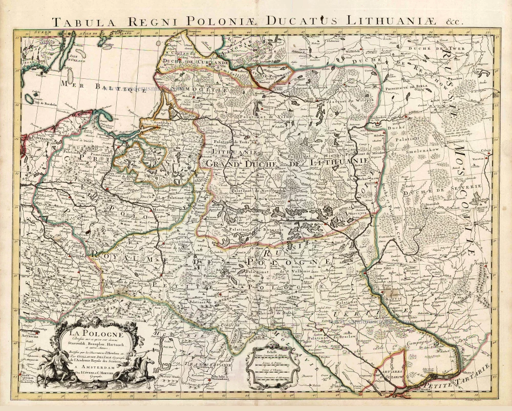
La Pologne Dressée sur ce qu'en ont donné Starovolsk, Beauplan, Hartnoch, et autres auteurs. [Latin title in upper margin:] Tabula Regni Poloniae, Ducatus Lithuaniae &c. 1730
Poland - Lithuania by Guillaume Delisle, published by Covens & Mortier.
[Item number: 25890]

Carte de la Lithuanie Russienne qui Comprend les Palatinats de Livonie, de Witepsk, de Miscislaw, et une Partie de ceux de Polock et de Minsk Cédés par la Pologne a la Russie. 1776-79
Bellarus and parts of Lithuania and Ukraine, by Francesco Santini.
[Item number: 26969]
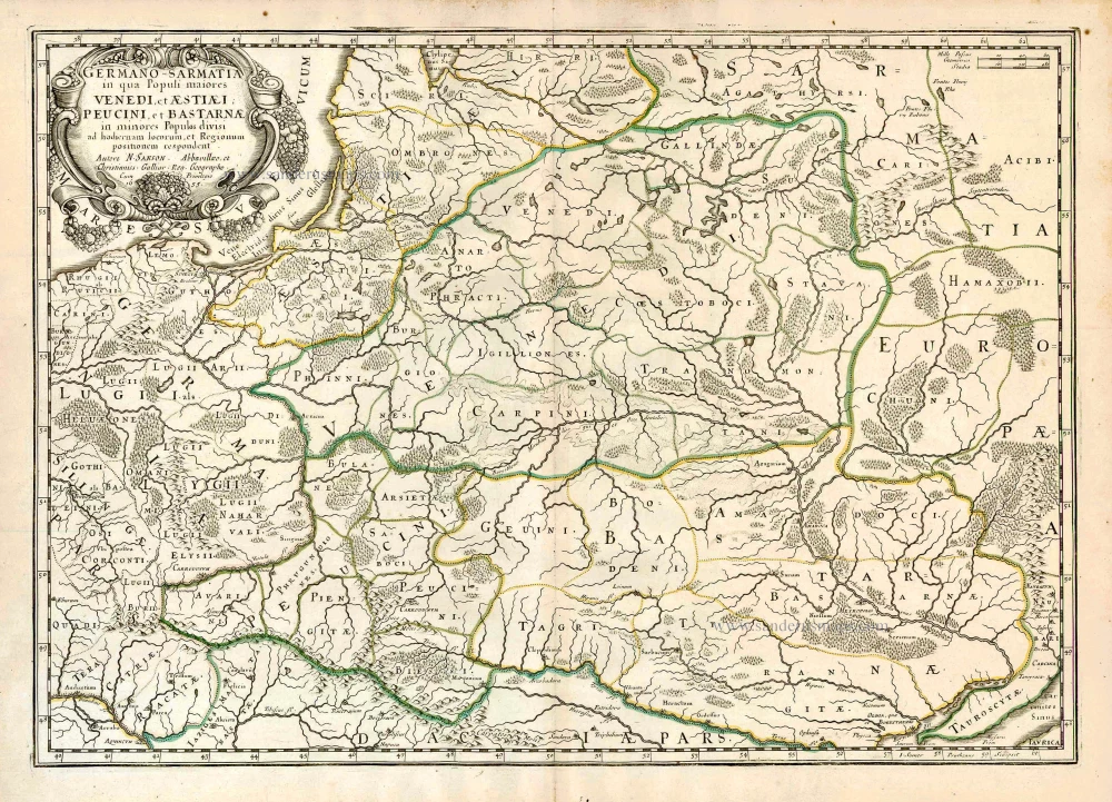
Germano-Sarmatia in qua populi maiores Venedi et Aestiaei Peucini et Bastarnae in minores populos divisi ad hodiernam locorum et regionum positionem respondent. 1658
Poland, Lithuania, Ukraine, Latvia, by Nicolas Sanson.
[Item number: 27918]
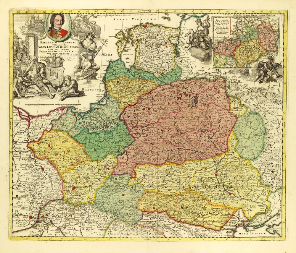
Friderico Augusto Vero Augusto Polon. Lithua. Borus. Pomer. Regi. Duci. Principi. Saxon. Utr. Duci. S. Imp. Elect. Haec. Imperii Sui Regna. c. 1715
Poland - Lithuania by Petrus Schenk.
[Item number: 28264]
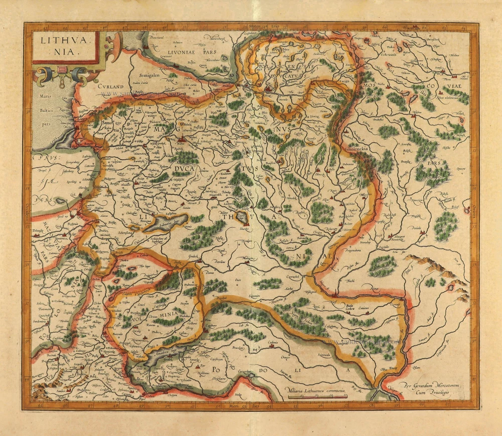
Lithuania. 1619
Grand Duchy of Lithuania, by Gerard Mercator.
[Item number: 28365]
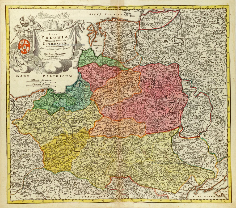
Regni Poloniae Magnique Ducatus Lithuaniae Nova et Exacta Tabula. After 1715
Poland & Lithuania by J.B. Homann
[Item number: 28830]
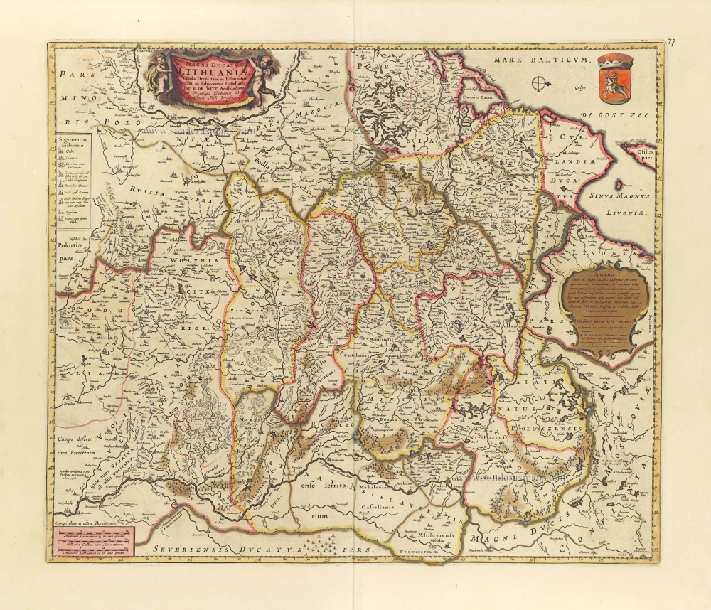
Magni Ducatus Lithuaniae Tabula, divisa tam in Palatinatus, quam in subjacentes Castellanias. c. 1697
Lithuania by Frederick De Wit.
[Item number: 28892]