
Montpellier - Tours - Poitiers, by Georg Braun and Frans Hogenberg. 1612


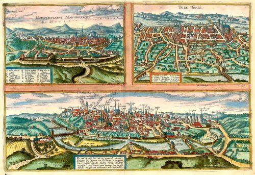
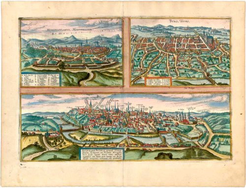
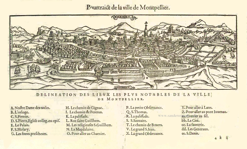
Montpellier: With a key to locations. In his brief description of the city, Braun focuses on the university Pope Nicholas IV founded in 1289. On the other hand, he does not mention the church of Notre Dame des Tables, which is recognizable by its tall spire. Since the Middle Ages, the church has been a stopping point for pilgrims on their way to Santiago di Compostella.
Tours: With a key to locations. The abbey of Saint-Martin, which was destroyed in 1562, is here still intact. Unmistakable on the right is the late Gothic cathedral of Saint-Gatien (13th-16th cent.), which was built after the previous Romanesque church burned down and which houses the relics of the first bishop of Tours, Gatianus. Standing on the left, outside the first city wall, is the abbey of Saint-Julien from the 12th/13th centuries.
Poitiers: Cartouche: Pictavis or Pictavia, in the local vernacular Poitiers, capital of the Pictavi or Pictones, noteworthy for its university, for the ruins of a large theatre, for ancient monuments, for magnificent ecclesiastical and secular buildings.
The captions in this engraving are given in particular detail. It is thus possible to recognize e.g. the famous Romanesque church of Notre-Dame-la-Grande, and the basilica of Saint-Hilaire-le-Grand. The imposing building rising above the rest in the centre of the picture is the Gothic cathedral of Saint-Pierre.
Braun G. & Hogenberg F. and the Civitates Orbis Terrarum.
The Civitates Orbis Terrarum, also known as the 'Braun & Hogenberg', is a six-volume town atlas and the most excellent book of town views and plans ever published: 363 engravings, sometimes beautifully coloured. It was one of the best-selling works in the last quarter of the 16th century. Georg Braun, a skilled writer, wrote the text accompanying the plans and views on the verso. Many plates were engraved after the original drawings of a professional artist, Joris Hoefnagel (1542-1600). The first volume was published in Latin in 1572 and the sixth in 1617. Frans Hogenberg, a talented engraver, created the tables for volumes I through IV, and Simon van den Neuwel made those for volumes V and VI. Other contributors were cartographers Daniel Freese and Heinrich Rantzau, who provided valuable geographical information. Works by Jacob van Deventer, Sebastian Münster, and Johannes Stumpf were also used as references. Translations appeared in German and French, making the atlas accessible to a broader audience.
Since its original publication of volume 1 in 1572, the Civitates Orbis Terrarum has left an indelible mark on the history of cartography. Seven more editions followed the first volume in 1575, 1577, 1582, 1588, 1593, 1599, and 1612. Vol.2, initially released in 1575, saw subsequent editions in 1597 and 1612. The subsequent volumes, each a treasure trove of historical insights, graced the world in 1581, 1588, 1593, 1599, and 1606. The German translation of the first volume, a testament to its widespread appeal, debuted in 1574, followed by the French edition in 1575.
Several printers were involved: Theodor Graminaeus, Heinrich von Aich, Gottfried von Kempen, Johannis Sinniger, Bertram Buchholtz, and Peter von Brachel, all of whom worked in Cologne.
Georg Braun (1541-1622)
Georg Braun, the author of the text accompanying the plans and views in the Civitates Orbis Terrarum, was born in Cologne in 1541. After his studies in Cologne, he entered the Jesuit Order as a novice, indicating his commitment to learning and intellectual pursuits. In 1561, he obtained his bachelor's degree; in 1562, he received his Magister Artium, further demonstrating his academic achievements. Although he left the Jesuit Order, he continued his studies in theology, gaining a licentiate in theology. His theological background likely influenced the content and tone of the text in the Civitates Orbis Terrarum, adding a unique perspective to the work.
Frans Hogenberg (1535-1590)
Frans Hogenberg was a Flemish and German painter, engraver, and mapmaker. He was born in Mechelen as the son of Nicolaas Hogenberg.
By the end of the 1560s, Frans Hogenberg was employed upon Abraham Ortelius's Theatrum Orbis Terrarum, published in 1570; he is named an engraver of numerous maps. In 1568, he was banned from Antwerp by the Duke of Alva and travelled to London, where he stayed a few years before emigrating to Cologne. He immediately embarked on his two most important works, the Civitates, published in 1572 and the Geschichtsblätter, which appeared in several series from 1569 until about 1587.
Thanks to large-scale projects like the Geschichtsblätter and the Civitates, Hogenberg's social circumstances improved with each passing year. He died as a wealthy man in Cologne in 1590.
Monspessulanus, Montpellier [on sheet with] Turo, Tours [and] Pictavis, sive Pictavia, Vernaculo Idiomate Poitiers.
Item Number: 23204 Authenticity Guarantee
Category: Antique maps > Europe > France - Cities
Old, antique bird’s-eye view plan of Montpellier - Tours - Poitiers, by Georg Braun & Frans Hogenberg.
Title: Monspessulanus, Montpellier [on sheet with] Turo, Tours [and] Pictavis, sive Pictavia, Vernaculo Idiomate Poitiers.
Cum Privilegio.
Date of the first edition: 1572.
Date of this map: 1612.
Copper engraving, printed on paper.
Size (not including margins): 325 x 485mm (12.8 x 19.09 inches).
Verso: Latin text.
Condition: Original coloured, excellent.
Condition Rating: A+.
References: Taschen, Braun and Hogenberg, p.60
From: Civitates Orbis Terrarum, Liber Primus. Cologne, Petrus von Brachel, 1612. (Van der Krogt 4, 41:1.1(1612))
Montpellier: With a key to locations. In his brief description of the city, Braun focuses on the university Pope Nicholas IV founded in 1289. On the other hand, he does not mention the church of Notre Dame des Tables, which is recognizable by its tall spire. Since the Middle Ages, the church has been a stopping point for pilgrims on their way to Santiago di Compostella.
Tours: With a key to locations. The abbey of Saint-Martin, which was destroyed in 1562, is here still intact. Unmistakable on the right is the late Gothic cathedral of Saint-Gatien (13th-16th cent.), which was built after the previous Romanesque church burned down and which houses the relics of the first bishop of Tours, Gatianus. Standing on the left, outside the first city wall, is the abbey of Saint-Julien from the 12th/13th centuries.
Poitiers: Cartouche: Pictavis or Pictavia, in the local vernacular Poitiers, capital of the Pictavi or Pictones, noteworthy for its university, for the ruins of a large theatre, for ancient monuments, for magnificent ecclesiastical and secular buildings.
The captions in this engraving are given in particular detail. It is thus possible to recognize e.g. the famous Romanesque church of Notre-Dame-la-Grande, and the basilica of Saint-Hilaire-le-Grand. The imposing building rising above the rest in the centre of the picture is the Gothic cathedral of Saint-Pierre.
Braun G. & Hogenberg F. and the Civitates Orbis Terrarum.
The Civitates Orbis Terrarum, also known as the 'Braun & Hogenberg', is a six-volume town atlas and the most excellent book of town views and plans ever published: 363 engravings, sometimes beautifully coloured. It was one of the best-selling works in the last quarter of the 16th century. Georg Braun, a skilled writer, wrote the text accompanying the plans and views on the verso. Many plates were engraved after the original drawings of a professional artist, Joris Hoefnagel (1542-1600). The first volume was published in Latin in 1572 and the sixth in 1617. Frans Hogenberg, a talented engraver, created the tables for volumes I through IV, and Simon van den Neuwel made those for volumes V and VI. Other contributors were cartographers Daniel Freese and Heinrich Rantzau, who provided valuable geographical information. Works by Jacob van Deventer, Sebastian Münster, and Johannes Stumpf were also used as references. Translations appeared in German and French, making the atlas accessible to a broader audience.
Since its original publication of volume 1 in 1572, the Civitates Orbis Terrarum has left an indelible mark on the history of cartography. Seven more editions followed the first volume in 1575, 1577, 1582, 1588, 1593, 1599, and 1612. Vol.2, initially released in 1575, saw subsequent editions in 1597 and 1612. The subsequent volumes, each a treasure trove of historical insights, graced the world in 1581, 1588, 1593, 1599, and 1606. The German translation of the first volume, a testament to its widespread appeal, debuted in 1574, followed by the French edition in 1575.
Several printers were involved: Theodor Graminaeus, Heinrich von Aich, Gottfried von Kempen, Johannis Sinniger, Bertram Buchholtz, and Peter von Brachel, all of whom worked in Cologne.
Georg Braun (1541-1622)
Georg Braun, the author of the text accompanying the plans and views in the Civitates Orbis Terrarum, was born in Cologne in 1541. After his studies in Cologne, he entered the Jesuit Order as a novice, indicating his commitment to learning and intellectual pursuits. In 1561, he obtained his bachelor's degree; in 1562, he received his Magister Artium, further demonstrating his academic achievements. Although he left the Jesuit Order, he continued his studies in theology, gaining a licentiate in theology. His theological background likely influenced the content and tone of the text in the Civitates Orbis Terrarum, adding a unique perspective to the work.
Frans Hogenberg (1535-1590)
Frans Hogenberg was a Flemish and German painter, engraver, and mapmaker. He was born in Mechelen as the son of Nicolaas Hogenberg.
By the end of the 1560s, Frans Hogenberg was employed upon Abraham Ortelius's Theatrum Orbis Terrarum, published in 1570; he is named an engraver of numerous maps. In 1568, he was banned from Antwerp by the Duke of Alva and travelled to London, where he stayed a few years before emigrating to Cologne. He immediately embarked on his two most important works, the Civitates, published in 1572 and the Geschichtsblätter, which appeared in several series from 1569 until about 1587.
Thanks to large-scale projects like the Geschichtsblätter and the Civitates, Hogenberg's social circumstances improved with each passing year. He died as a wealthy man in Cologne in 1590.
Related items

Monspessulanus, Montpellier [on sheet with] Turo, Tours [and] Pictavis, sive Pictavia, Vernaculo Idiomate Poitiers 1612
Montpellier - Tours - Poitiers by Braun & Hogenberg
[Item number: 22305]

Poictou - Pictonum Vicinarum que Regionum Fidiss Descriptio 1598
Poitiers, by Ortelius A.
[Item number: 23104]

Les Bas Cevennes, Dans le Languedoc, ou le Diocese de Montpellier Divisé en Neuf Archiprêtrez 1721-41
The Cévennes with the bishopric of Montpellier, by C. Allard - Covens & Mortier.
[Item number: 23791]

Turones vulgo Tours, le Iardin de France. [on sheet with:] Andegavum vulgo Angiers 1596
Tours and Angers, by Georg Braun and Frans Hogenberg.
[Item number: 24151]
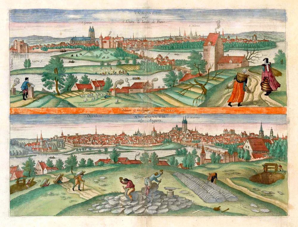
Turones vulgo Tours, le Iardin de France. [on sheet with:] Andegavum vulgo Angiers. c. 1610
Tours and Angers, by Georg Braun and Frans Hogenberg.
[Item number: 25956]

De la ville de Poytiers. 1575
Poitiers, by François de Belleforest.
[Item number: 27194]
Pourtraict de la ville de Montpellier. 1575
Montpellier, by François de Belleforest.
[Item number: 27254]