
Languedoc (South) by Henricus Hondius. 1631
The Hondius Family
Jodocus Hondius the Elder (1563-1612)
Joost d’Hondt was born at Wakken (Flanders) in 1563. Two years later, his family settled down in Ghent, where young Joost displayed a great gift for drawing and calligraphy. By study and lessons, he developed his talents and became an engraver with a good reputation.
Due to the circumstances of war, he moved in 1584 to London where he settled down as an engraver, instrument-maker and map-maker. In 1587, he married Coletta van den Keere, sister of the well-known engraver, Pieter van den Keere (Petrus Kaerius); some years earlier his sister, Jacomina, had married Pieter van den Berghe (Petrus Montanus). Joost, who had latinized his name to Jodocus Hondius, closely co-operated with his two brothers-in-law.
The political situation in the Northern Netherlands in 1593 was such that Jodocus seemed to be justified in establishing himself in Amsterdam, where so many Antwerp printers, publishers, and engravers had gone. In this new centre of cartography, Jodocus Hondius set up his business “In de Wackere Hondt” (in the vigilant dog), this name being an allusion to his birthplace and name. Here he engraved many maps and published atlases and many other works such as his continuation of Gerard Mercator’s Atlas.
He suddenly passed away in February 1612. The publishing firm of Jodocus Hondius was continued by his widow; later on by his two sons Jodocus Jr., and Henricus, and by his son-in-law, J. Janssonius.
Jodocus Hondius II (1594-1629) & Henricus Hondius (1597-1651)
After the father’s death, the widow with her seven children continued publishing the atlases under the name of Jodocus Hondius till 1620. The firm was reinforced by the very welcome help of Joannes Janssonius (1588-1664), who married 24-year-old Elisabeth Hondius in 1612. After 1619 Mercator’s Atlas was published under the name of Henricus Hondius.
One of the most dramatic events in the early history of commercial cartography in Amsterdam was the sale of Jodocus Hondius Jr.’s copper-plates to Willem Jansz. Blaeu in 1629, the year of his death. At least 34 plates, from which Jodocus II had printed single-sheet maps for his own benefit, passed into the hands of his great competitor. Immediately after that, his brother, Henricus, and Joannes Janssonius ordered the engraving of identical plates.
During a long period, Henricus devoted all his energy to the publication of the Atlas. He saw its growth up to, and including, the fourth part in 1646; after that, his name does not figure any more on the title-pages. After 1638, the title of the Atlas was changed to Atlas Novus; it was mainly carried on by Joannes Janssonius.
The competition with the Blaeus dates from 1630. In 1630, Willem Janszoon (=Blaeu) made the first attack with his Atlantis Appendix. In 1635, Blaeu completed his Theatrum orbis terrarum in two volumes with texts in French, Latin, Dutch, and German, which prompted Henricus Hondius to speed up the enlargement of his Atlas.
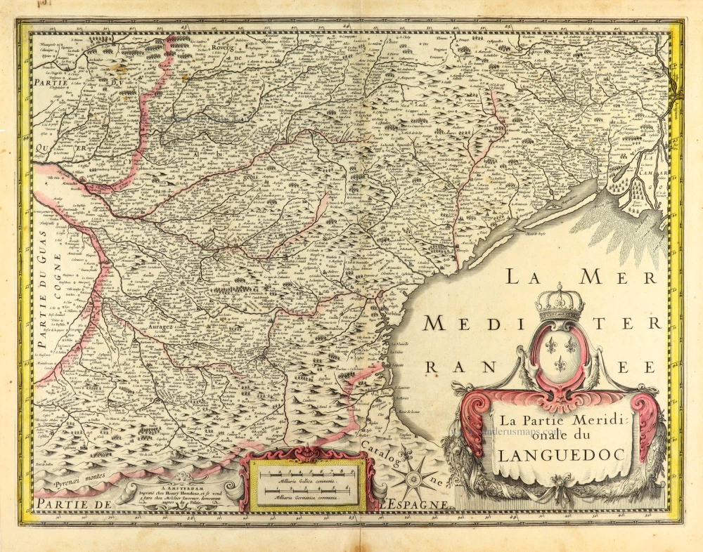
La Partie Meridionale du Languedoc.
Item Number: 30093 Authenticity Guarantee
Category: Antique maps > Europe > France
Old, antique map of the Languedoc (South) by Henricus Hondius.
Title: La Partie Meridionale du Languedoc.
A Amsterdam Imprimé chez Henry Hondius, et se vend a Paris chez Melchior Tavernier, demeurant aupres du Palais.
Date of the first edition: 1631.
Date of this map: 1631.
Copper engraving, printed on paper.
Image size: 375 x 490mm (14.76 x 19.29 inches).
Sheet size: 415 x 530mm (16.34 x 20.87 inches).
Verso: Blank.
Condition: Original coloured, lower centrefold reinforced.
Condition Rating: A.
From: Atlantis Maioris Appendix, Sive Pars Altera, Continens Geographicas Tabulas diversarum orbis Regionum & Provinciarum octoginta tres, nunc primum editas: Quarum nomina & Catalogum sequens pagina indicabit. Amstelodami, Sumptibus & typis aeneis Henrici Hondii. MDCXXXI. [1631] (Van der Krogt 1:203)
The Hondius Family
Jodocus Hondius the Elder (1563-1612)
Joost d’Hondt was born at Wakken (Flanders) in 1563. Two years later, his family settled down in Ghent, where young Joost displayed a great gift for drawing and calligraphy. By study and lessons, he developed his talents and became an engraver with a good reputation.
Due to the circumstances of war, he moved in 1584 to London where he settled down as an engraver, instrument-maker and map-maker. In 1587, he married Coletta van den Keere, sister of the well-known engraver, Pieter van den Keere (Petrus Kaerius); some years earlier his sister, Jacomina, had married Pieter van den Berghe (Petrus Montanus). Joost, who had latinized his name to Jodocus Hondius, closely co-operated with his two brothers-in-law.
The political situation in the Northern Netherlands in 1593 was such that Jodocus seemed to be justified in establishing himself in Amsterdam, where so many Antwerp printers, publishers, and engravers had gone. In this new centre of cartography, Jodocus Hondius set up his business “In de Wackere Hondt” (in the vigilant dog), this name being an allusion to his birthplace and name. Here he engraved many maps and published atlases and many other works such as his continuation of Gerard Mercator’s Atlas.
He suddenly passed away in February 1612. The publishing firm of Jodocus Hondius was continued by his widow; later on by his two sons Jodocus Jr., and Henricus, and by his son-in-law, J. Janssonius.
Jodocus Hondius II (1594-1629) & Henricus Hondius (1597-1651)
After the father’s death, the widow with her seven children continued publishing the atlases under the name of Jodocus Hondius till 1620. The firm was reinforced by the very welcome help of Joannes Janssonius (1588-1664), who married 24-year-old Elisabeth Hondius in 1612. After 1619 Mercator’s Atlas was published under the name of Henricus Hondius.
One of the most dramatic events in the early history of commercial cartography in Amsterdam was the sale of Jodocus Hondius Jr.’s copper-plates to Willem Jansz. Blaeu in 1629, the year of his death. At least 34 plates, from which Jodocus II had printed single-sheet maps for his own benefit, passed into the hands of his great competitor. Immediately after that, his brother, Henricus, and Joannes Janssonius ordered the engraving of identical plates.
During a long period, Henricus devoted all his energy to the publication of the Atlas. He saw its growth up to, and including, the fourth part in 1646; after that, his name does not figure any more on the title-pages. After 1638, the title of the Atlas was changed to Atlas Novus; it was mainly carried on by Joannes Janssonius.
The competition with the Blaeus dates from 1630. In 1630, Willem Janszoon (=Blaeu) made the first attack with his Atlantis Appendix. In 1635, Blaeu completed his Theatrum orbis terrarum in two volumes with texts in French, Latin, Dutch, and German, which prompted Henricus Hondius to speed up the enlargement of his Atlas.
Related items

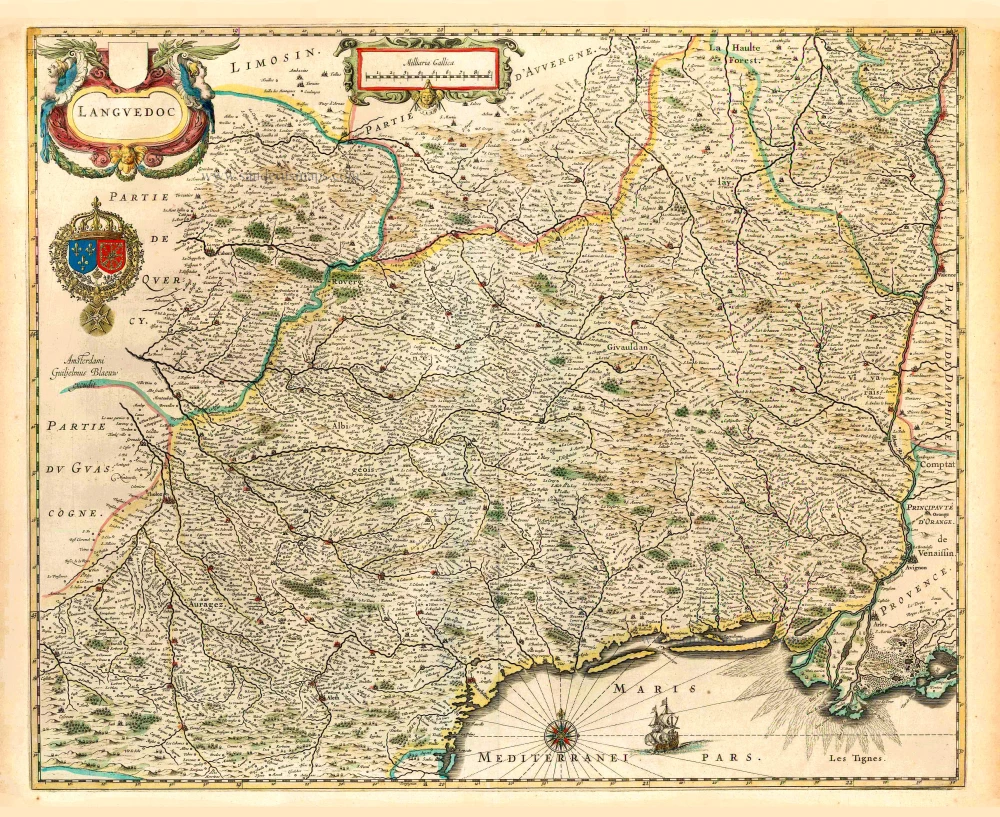
La Partie Septentrionale du Languedoc. 1630
Languedoc (North), by Joannes Janssonius.
[Item number: 6912]

Scarce sea chart
Languedoc tusschen C. de Creos en C. delle Melle. 1664
Provence by Doncker H., sea chart.
[Item number: 13696]
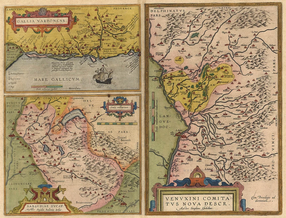
Gallia Narbonens [on sheet with] Sabaudiae Ducat. [and] Venuxini Comitatus Nova Descr. 1612.
Languedoc, Savoie, Venaissin, by Ortelius A.
[Item number: 19362]
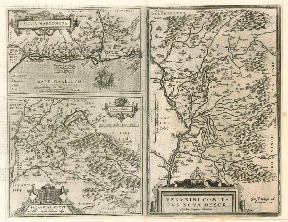
Gallia Narbonens [on sheet with] Sabaudiae Ducat. [and] Venuxini Comitatus Nova Descr. 1598
Languedoc, Savoie and Venaissin, by Ortelius A.
[Item number: 23105]

Le Gouvernement General de Languedoc Divisé en Trois Lieutenances Generales ... 1710
Languedoc-Roussillon, by N. Sanson.
[Item number: 23788]

Gouvernement General de Languedoc. Divisé en ses Vint Deux Diocesez. 1691-96
Languedoc, by F. De Wit.
[Item number: 24372]

Galliae Narbonensis Ora Marittima Recenter descripta. [on sheet with:] Sabaudiae, et Burgundiae Comitatus descriptio; auctore Aegidio Bulionio Belga. 1572
Languedoc and Savoie, by A. Ortelius.
[Item number: 25437]

Carte du Gouvernement de Languedoc. 1713
The Languedoc, by P. Van der Aa.
[Item number: 26167]

Praefectura Generalis Languedociae ... c. 1700
Languedoc, by G. & L. Valck.
[Item number: 26217]
Languedoc. 1640
Languedoc, by Willem Blaeu.
[Item number: 27155]
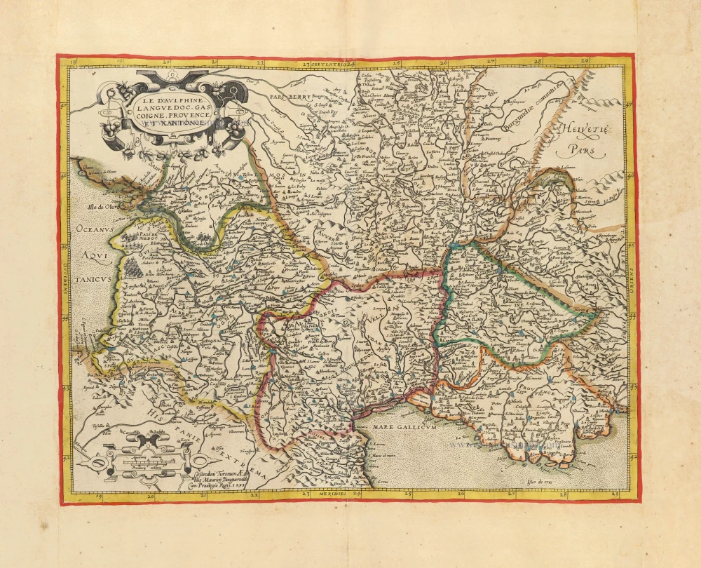
Le Dauphiné, Languedoc, Gascoigne, Provence et Xaintonge. c. 1610-1650
Southern France by Jean Leclerc & Maurice Bouguereau, after G. Mercator.
[Item number: 30890]

Carte Generale de Guyenne. c. 1610-1650
Southwest France by Christophe Tassin. RARE
[Item number: 31310]

Languedoc. 1618
Languedoc by Petrus Bertius, published by Jodocus Hondius II.
[Item number: 31594]