
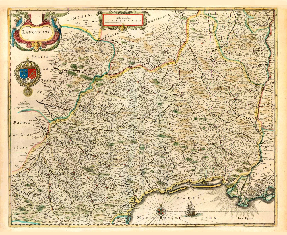
Languedoc, by Willem Blaeu. 1640
The Blaeus: Willem Janszoon, Cornelis & Joan
Willem Jansz. Blaeu and his son Joan Blaeu are the seventeenth century's most widely known cartographic publishers.
Willem Jansz. (also written Guilielmus Janssonius) = Willem Janszoon Blaeu was born in Uitgeest (Netherlands), near Alkmaar, in 1571. He studied mathematics under Tycho Brahe and learned the theory and practice of astronomical observations and the art of instrument- and globe-making.
In 1596, he came to Amsterdam, where he settled down as a globe-, instrument- and mapmaker. He published his first cartographic work (a globe) in 1599 and probably published his first printed map (a map of the Netherlands) in 1604. He specialised in maritime cartography, published the first edition of the pilot guide Het Licht der Zeevaert in 1608, and was appointed Hydrographer of the V.O.C. (United East India Company) in 1633. After publishing books, wall maps, globes, charts and pilot guides for thirty years, he brought out his first atlas, Atlas Appendix (1630). This was the beginning of the great tradition of atlas-making by the Blaeus.
In 1618, another mapmaker, bookseller and publisher, Johannes Janssonius, established himself in Amsterdam next door to Blaeu's shop. No wonder these two neighbours began accusing each other of copying and stealing their information and became fierce competitors who did not have a good word to say about each other. In about 1621 Willem Jansz. decided to end the confusion between his name and his competitor's and assumed his grandfather's nickname, 'blauwe Willem' ('blue Willem'), as the family name; after that, he called himself Willem Jansz. Blaeu.
Willem Janszoon Blaeu died in 1638, leaving his prospering business to his sons, Cornelis and Joan. We only know that Cornelis's name occurs in the prefaces of books and atlases until c. 1645.
Joan Blaeu, born in Amsterdam in 1596, became a partner in his father's book trade and printing business. 1638, he was appointed his father's successor in the Hydrographic Office of the V.O.C. His efforts culminated in the magnificent Atlas Major and the town books of the Netherlands and Italy – works unsurpassed in history and modern times, giving eternal fame to the name of the Blaeu's.
A fire ruined the business on February 23, 1672, and one year later, Dr. Joan Blaeu died. The fire and the director's passing caused the complete sale of the Blaeu House's stock. Five public auctions dispersed the remaining books, atlases, copperplates, globes, etc., among many other map dealers and publishers in Amsterdam. The majority was acquired by several booksellers acting in partnership.
In the succeeding years, the remaining printing department remained in the hands of the Blaeu family until 1695, when the printing house's inventory was sold at a public auction. That meant the end of the Blaeu family as a printing house of world renown.
Languedoc.
Item Number: 27155 Authenticity Guarantee
Category: Antique maps > Europe > France
Old, antique map of the Languedoc, by Willem Blaeu.
Ancienne carte antique du Languedoc, par Willem Blaeu.
Date of the first edition: 1631
Date of this map: 1635
Copper engraving
Size (not including margins): 44 x 54.5cm (17.2 x 21.3 inches)
Verso text: French
Condition: Excellent.
Condition Rating: A
References: Van der Krogt 2, 4650:2.
From: Théâtre du Monde ou Nouvel Atlas. J. Blaeu, 1635. (Van der Krogt 2, 2111)
The Blaeus: Willem Janszoon, Cornelis & Joan
Willem Jansz. Blaeu and his son Joan Blaeu are the seventeenth century's most widely known cartographic publishers.
Willem Jansz. (also written Guilielmus Janssonius) = Willem Janszoon Blaeu was born in Uitgeest (Netherlands), near Alkmaar, in 1571. He studied mathematics under Tycho Brahe and learned the theory and practice of astronomical observations and the art of instrument- and globe-making.
In 1596, he came to Amsterdam, where he settled down as a globe-, instrument- and mapmaker. He published his first cartographic work (a globe) in 1599 and probably published his first printed map (a map of the Netherlands) in 1604. He specialised in maritime cartography, published the first edition of the pilot guide Het Licht der Zeevaert in 1608, and was appointed Hydrographer of the V.O.C. (United East India Company) in 1633. After publishing books, wall maps, globes, charts and pilot guides for thirty years, he brought out his first atlas, Atlas Appendix (1630). This was the beginning of the great tradition of atlas-making by the Blaeus.
In 1618, another mapmaker, bookseller and publisher, Johannes Janssonius, established himself in Amsterdam next door to Blaeu's shop. No wonder these two neighbours began accusing each other of copying and stealing their information and became fierce competitors who did not have a good word to say about each other. In about 1621 Willem Jansz. decided to end the confusion between his name and his competitor's and assumed his grandfather's nickname, 'blauwe Willem' ('blue Willem'), as the family name; after that, he called himself Willem Jansz. Blaeu.
Willem Janszoon Blaeu died in 1638, leaving his prospering business to his sons, Cornelis and Joan. We only know that Cornelis's name occurs in the prefaces of books and atlases until c. 1645.
Joan Blaeu, born in Amsterdam in 1596, became a partner in his father's book trade and printing business. 1638, he was appointed his father's successor in the Hydrographic Office of the V.O.C. His efforts culminated in the magnificent Atlas Major and the town books of the Netherlands and Italy – works unsurpassed in history and modern times, giving eternal fame to the name of the Blaeu's.
A fire ruined the business on February 23, 1672, and one year later, Dr. Joan Blaeu died. The fire and the director's passing caused the complete sale of the Blaeu House's stock. Five public auctions dispersed the remaining books, atlases, copperplates, globes, etc., among many other map dealers and publishers in Amsterdam. The majority was acquired by several booksellers acting in partnership.
In the succeeding years, the remaining printing department remained in the hands of the Blaeu family until 1695, when the printing house's inventory was sold at a public auction. That meant the end of the Blaeu family as a printing house of world renown.
Related items

La Partie Septentrionale du Languedoc. 1630
Languedoc (North), by Joannes Janssonius.
[Item number: 6912]

Scarce sea chart
Languedoc tusschen C. de Creos en C. delle Melle. 1664
Provence by Doncker H., sea chart.
[Item number: 13696]
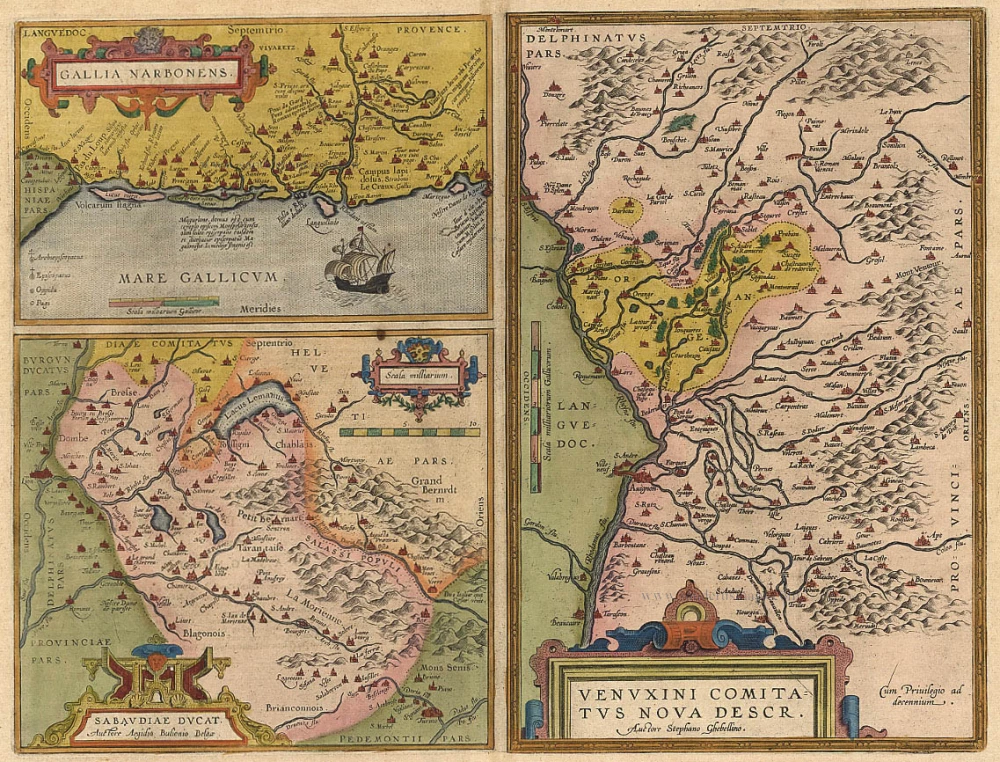
Gallia Narbonens [on sheet with] Sabaudiae Ducat. [and] Venuxini Comitatus Nova Descr. 1612.
Languedoc, Savoie, Venaissin, by Ortelius A.
[Item number: 19362]
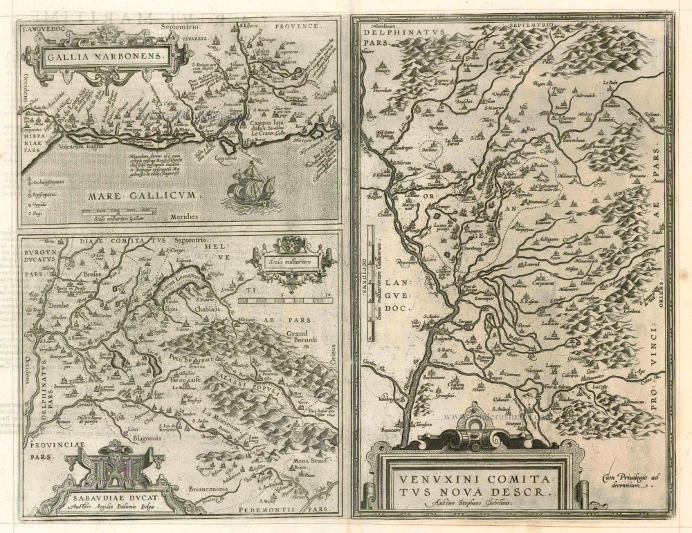
Gallia Narbonens [on sheet with] Sabaudiae Ducat. [and] Venuxini Comitatus Nova Descr. 1598
Languedoc, Savoie and Venaissin, by Ortelius A.
[Item number: 23105]

Le Gouvernement General de Languedoc Divisé en Trois Lieutenances Generales ... 1710
Languedoc-Roussillon, by N. Sanson.
[Item number: 23788]

Gouvernement General de Languedoc. Divisé en ses Vint Deux Diocesez. 1691-96
Languedoc, by F. De Wit.
[Item number: 24372]

Galliae Narbonensis Ora Marittima Recenter descripta. [on sheet with:] Sabaudiae, et Burgundiae Comitatus descriptio; auctore Aegidio Bulionio Belga. 1572
Languedoc and Savoie, by A. Ortelius.
[Item number: 25437]

Carte du Gouvernement de Languedoc. 1713
The Languedoc, by P. Van der Aa.
[Item number: 26167]

Praefectura Generalis Languedociae ... c. 1700
Languedoc, by G. & L. Valck.
[Item number: 26217]
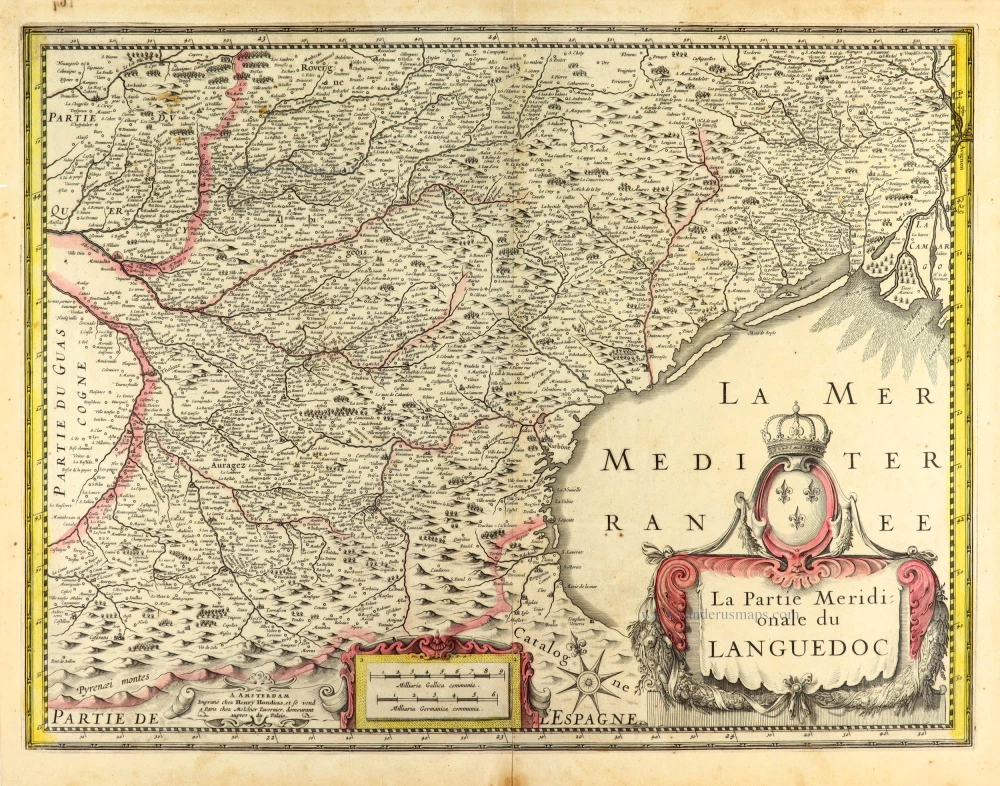
La Partie Meridionale du Languedoc. 1631
Languedoc (South) by Henricus Hondius.
[Item number: 30093]
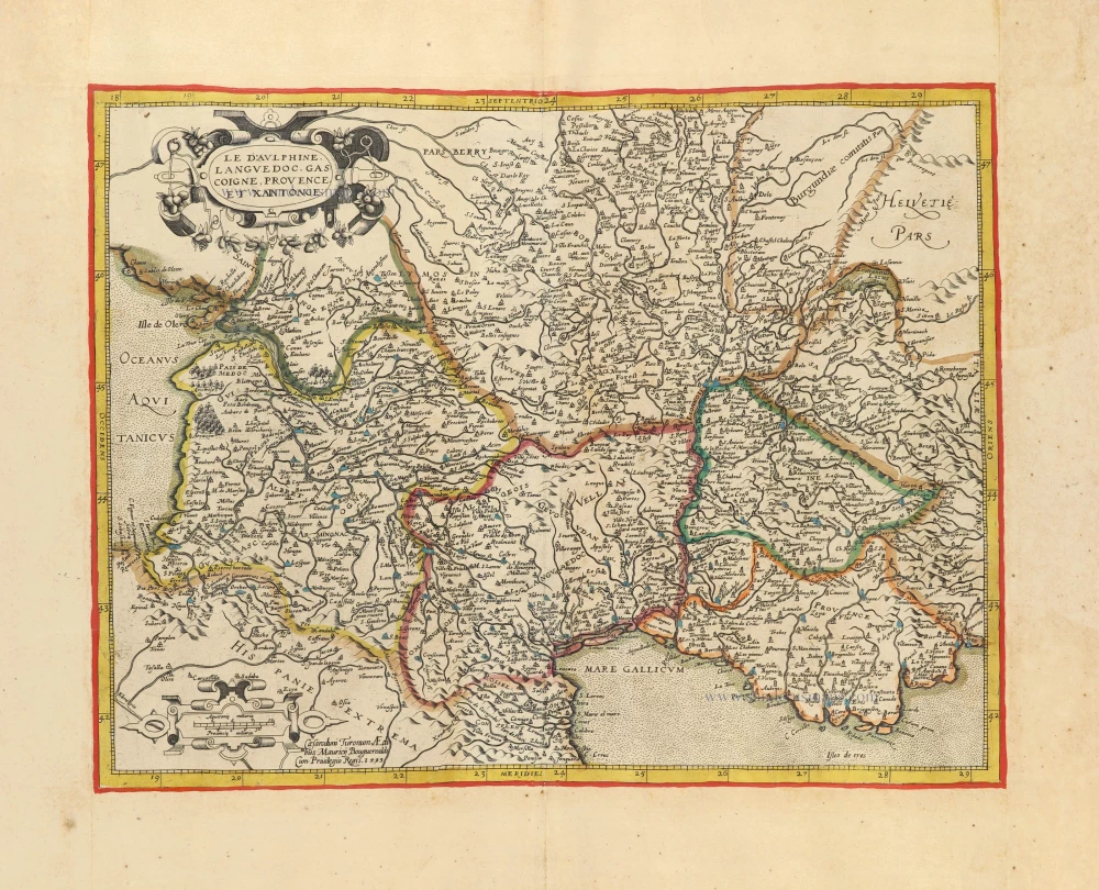
Le Dauphiné, Languedoc, Gascoigne, Provence et Xaintonge. c. 1610-1650
Southern France by Jean Leclerc & Maurice Bouguereau, after G. Mercator.
[Item number: 30890]

Carte Generale de Guyenne. c. 1610-1650
Southwest France by Christophe Tassin. RARE
[Item number: 31310]

Languedoc. 1618
Languedoc by Petrus Bertius, published by Jodocus Hondius II.
[Item number: 31594]