
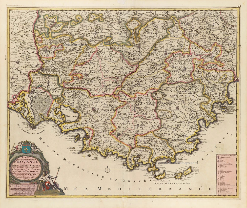
The Provence, by Frederick de Wit. c. 1705


Frederick de Wit (1630-1706)
The engraver and map-seller, Frederick de Wit, was born in Gouda (Netherlands) in 1630 as a son of Hendrick Fredericksz de Wit. Through his marriage with Maria van der Waag of Amsterdam in 1661, he obtained citizenship of the city where he had been working since 1648 and where he became one of the most famous engravers of maps of the second half of the 17th century. Although De Wit was a Catholic, which meant that he was not favoured at the time by the city council, he was awarded the honour of being listed as one of the "excellent citizens" on the roll of the city council in the years 1694-1704. However, his name was not written in the Guild of St. Luke book before 1664. At that time, he lived on the Kalverstraat "in de Witte Pascaert", where he stayed until his death in 1706. His earliest dates on maps engraved are 1659 (Regni Daniae) and 1660 (World map).
Frederick de Wit published several world atlases, a sea atlas, and an atlas of the Netherlands.
The dating of the maps is difficult. However, as a privilege was granted in 1689, the annotation 'cum privilegio' marks an edition after 1688.
Around 1700, Frederick de Wit entered the market with a town atlas. He produced two volumes with a total of 260 plans and views. Most were printed from plates used for Janssonius and Blaeu town atlases.
After he died in 1706, his widow continued the shop until 1709. The plates and stock of De Wit's atlas were sold to Covens & Mortier in 1710, who sold the atlas for an extended period.
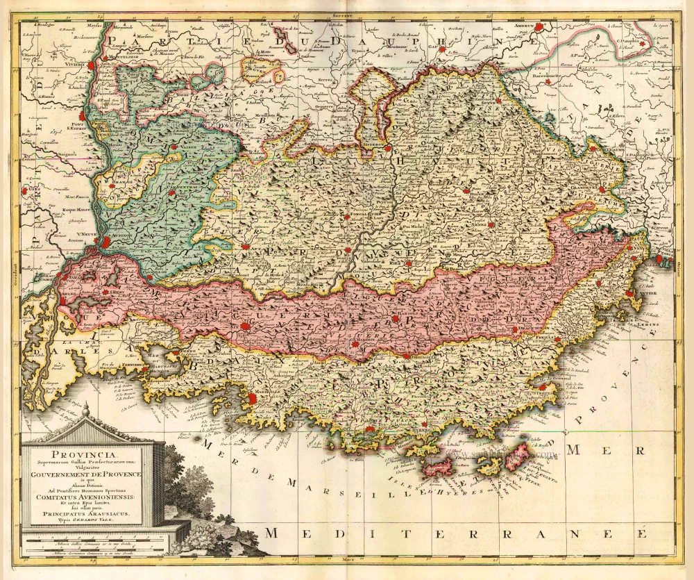
Comté et Gouvernement General de Provence.
Item Number: 28933 Authenticity Guarantee
Category: Antique maps > Europe > France
Old, antique map of Provence, by Frederick de Wit.
Title: Comté et Gouvernement General de Provence.
Divisé en ses Senechaussees et Viguerie avec le Terre adjacentes Scavoir La Principauté d'Orange, le Comtat Venaisin etc
Dressez sur le Memoires les plus Nouveaux
a Amsterdam Par F. de Witt
avec Privilege de nos tres Puissans Seigneurs les Etats d'Hollande et de Westfrise.
Date of the first edition: c. 1705.
Date of this map: c. 1705.
Copper engraving, printed on paper.
Map size: 480 x 585mm (18.9 x 23.03 inches).
Sheet size: 535 x 630mm (21.06 x 24.8 inches).
Verso: Blank.
Condition: Original coloured, green colour (verdigris) turned brown.
Condition Rating: A.
From: Atlas. Amsterdam, Frederick de Wit, after 1705. (Koeman, III p. 202, Wit16; Carhart p. 159 A157)
Frederick de Wit (1630-1706)
The engraver and map-seller, Frederick de Wit, was born in Gouda (Netherlands) in 1630 as a son of Hendrick Fredericksz de Wit. Through his marriage with Maria van der Waag of Amsterdam in 1661, he obtained citizenship of the city where he had been working since 1648 and where he became one of the most famous engravers of maps of the second half of the 17th century. Although De Wit was a Catholic, which meant that he was not favoured at the time by the city council, he was awarded the honour of being listed as one of the "excellent citizens" on the roll of the city council in the years 1694-1704. However, his name was not written in the Guild of St. Luke book before 1664. At that time, he lived on the Kalverstraat "in de Witte Pascaert", where he stayed until his death in 1706. His earliest dates on maps engraved are 1659 (Regni Daniae) and 1660 (World map).
Frederick de Wit published several world atlases, a sea atlas, and an atlas of the Netherlands.
The dating of the maps is difficult. However, as a privilege was granted in 1689, the annotation 'cum privilegio' marks an edition after 1688.
Around 1700, Frederick de Wit entered the market with a town atlas. He produced two volumes with a total of 260 plans and views. Most were printed from plates used for Janssonius and Blaeu town atlases.
After he died in 1706, his widow continued the shop until 1709. The plates and stock of De Wit's atlas were sold to Covens & Mortier in 1710, who sold the atlas for an extended period.
Related items
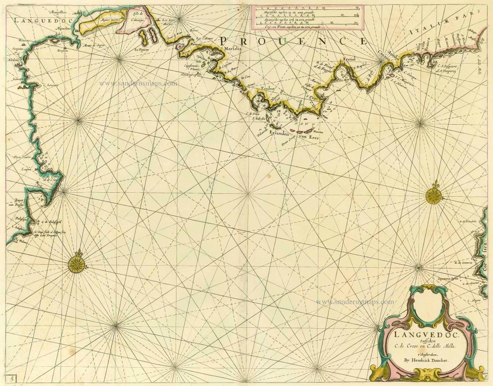
Scarce sea chart
Languedoc tusschen C. de Creos en C. delle Melle. 1664
Provence by Doncker H., sea chart.
[Item number: 13696]
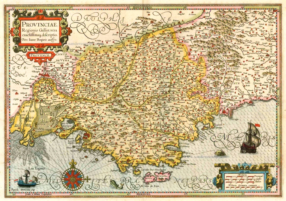
Provinciae, Regionis Galliae, vera exactissimaq. descriptio. 1613
Provence by Jodocus Hondius
[Item number: 25595]
Provincia. Supremarum Galliae Praefecturarum una; Vulgariter Gouvernement de Provence in qua Alienae Ditionis. ... c. 1700
The Provence, by G. Valk.
[Item number: 25679]

Provinciae, Regionis Galliae, vera exactissimaq. descriptio. 1623
Provence, by Jodocus Hondius.
[Item number: 27885]
Very rare!
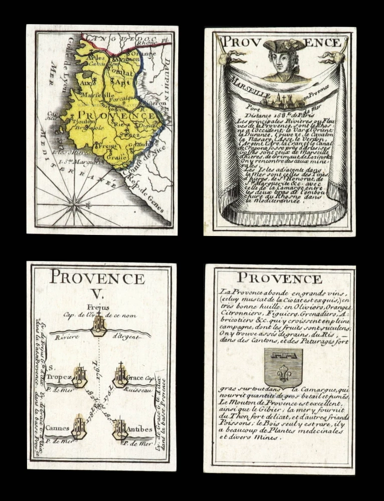
Provence. c. 1763
France - Provence, four geographical playing cards, designed by Nicolas Jean Baptiste de Poilly and printed by Jean-Baptiste Mitoire.
[Item number: 30328]
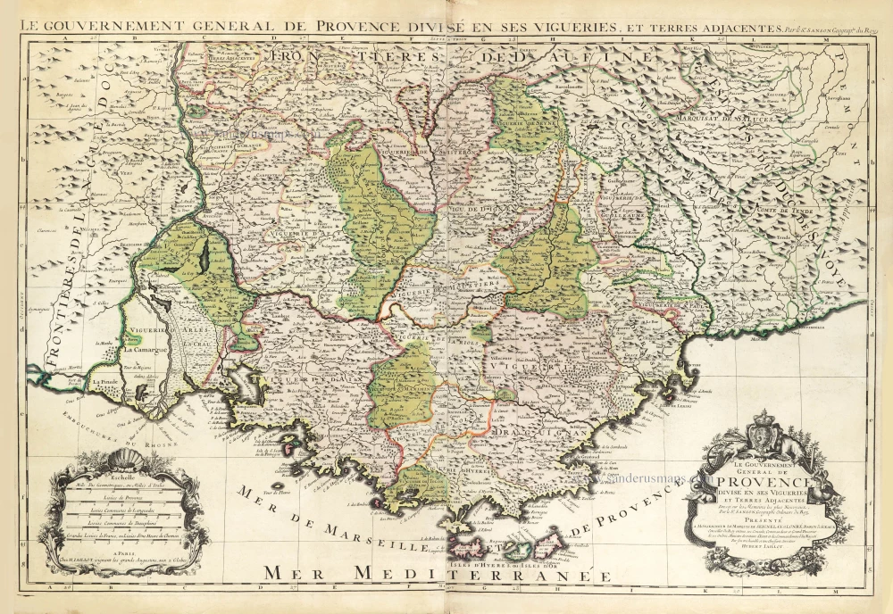
Le Gouvernement General de Provence divisé en ses Vigueries, et Terres Adjacentes. 1692
The Provence by Hubert Jaillot, after Nicolas Sanson.
[Item number: 30407]
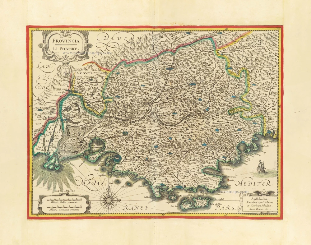
Provincia - La Provence c. 1621-1650
Provence by Jodocus and Henricus Hondius.
[Item number: 30892]

Provence. 1618
Provence by Petrus Bertius, published by Jodocus Hondius II.
[Item number: 31593]

Provincia Indigenis dicta La Provence divisa in omnes suos Vicariatus seu Praefecturas et Terras adjacentes eidem subjectas c. 1720
Provence by J.B. Homann
[Item number: 32157]

Le Gouvernement General de Provence divisé en ses Vigueries, et Terres Adjacentes. 1692
The Provence by Hubert Jaillot, after Nicolas Sanson.
[Item number: 32289]