
The Provence, by G. Valk. c. 1700

The Valk Family
Gerard Valk (Valck) (1652-1726) was Amsterdam's publisher, engraver, art seller, and globemaker. He was trained under Abraham Bloteling, later becoming his assistant. The two moved to London, where Valk worked with various map and print sellers. He married Abraham's sister, Maria Bloteling, in London around 1673; in that city, his son and successor, Leonard, was born in 1675.
Not long after, Bloteling and Valk returned to Amsterdam, where Gerard Valk was registered as a burgher on December 8, 1679.
Around 1680 he began working with the German engraver Petrus Schenk as an engraver, publisher, map and print-sellers. They acquired the plates for the Janssonius Novus Atlas and Sanson's maps. Although they never shared premises, they worked closely together in the publications of editions of these works. Valk and his son Leonard are best known for their globemaking. In addition to globes newly compiled from the latest geographical and astronomical information, the Valk's published theoretical works on astronomy and globes.
In 1710, the family tie between the two partners, Valk and Schenk, became even closer when Gerard's son Leonard Valk (1675-1746) married Maria Schenk (1688-1770), Petrus' daughter.
After the death of Gerard in 1726, the business continued in the hands of his son Leonard and Gerard's widow Maria until she died in 1729, and then by Leonard until he died in 1746.
Provincia. Supremarum Galliae Praefecturarum una; Vulgariter Gouvernement de Provence in qua Alienae Ditionis. ...
Item Number: 25679 Authenticity Guarantee
Category: Antique maps > Europe > France
Old antique map of the Provence by G. Valk.
Title: Provincia. Supremarum Galliae Praefecturarum una; Vulgariter Gouvernement de Provence in qua Alienae Ditionis. ...
Date: c. 1700.
Copper engraving, printed on paper.
Size (not including margins): 495 x 600mm (19.49 x 23.62 inches).
Verso: Blank.
Condition: Original coloured, excellent.
Condition Rating: A+.
From: Atlas Contractus sive Mapparum Geographicarum Sansoniarum auctarum et correctarum Nova Congeries. Amsterdam, P. Schenk, c. 1700. (Koeman, Sche 1)
The Valk Family
Gerard Valk (Valck) (1652-1726) was Amsterdam's publisher, engraver, art seller, and globemaker. He was trained under Abraham Bloteling, later becoming his assistant. The two moved to London, where Valk worked with various map and print sellers. He married Abraham's sister, Maria Bloteling, in London around 1673; in that city, his son and successor, Leonard, was born in 1675.
Not long after, Bloteling and Valk returned to Amsterdam, where Gerard Valk was registered as a burgher on December 8, 1679.
Around 1680 he began working with the German engraver Petrus Schenk as an engraver, publisher, map and print-sellers. They acquired the plates for the Janssonius Novus Atlas and Sanson's maps. Although they never shared premises, they worked closely together in the publications of editions of these works. Valk and his son Leonard are best known for their globemaking. In addition to globes newly compiled from the latest geographical and astronomical information, the Valk's published theoretical works on astronomy and globes.
In 1710, the family tie between the two partners, Valk and Schenk, became even closer when Gerard's son Leonard Valk (1675-1746) married Maria Schenk (1688-1770), Petrus' daughter.
After the death of Gerard in 1726, the business continued in the hands of his son Leonard and Gerard's widow Maria until she died in 1729, and then by Leonard until he died in 1746.
Related items

Scarce sea chart
Languedoc tusschen C. de Creos en C. delle Melle. 1664
Provence by Doncker H., sea chart.
[Item number: 13696]
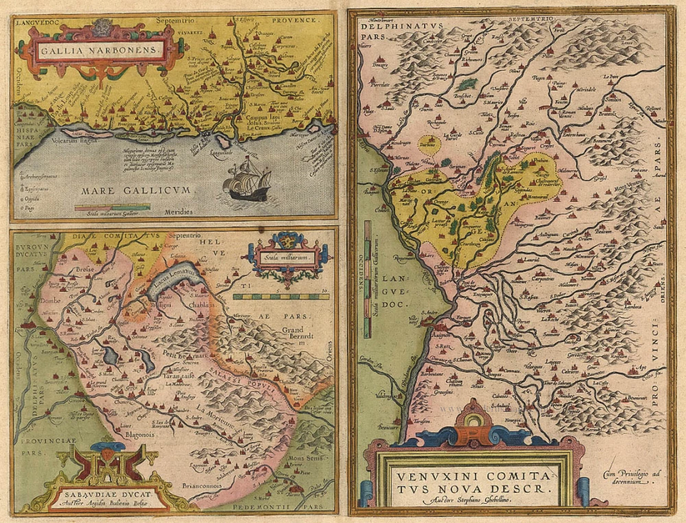
Gallia Narbonens [on sheet with] Sabaudiae Ducat. [and] Venuxini Comitatus Nova Descr. 1612.
Languedoc, Savoie, Venaissin, by Ortelius A.
[Item number: 19362]

Les Bas Cevennes, Dans le Languedoc, ou le Diocese de Montpellier Divisé en Neuf Archiprêtrez 1721-41
The Cévennes with the bishopric of Montpellier, by C. Allard - Covens & Mortier.
[Item number: 23791]

Gouvernement General de Languedoc. Divisé en ses Vint Deux Diocesez. 1691-96
Languedoc, by F. De Wit.
[Item number: 24372]

Galliae Narbonensis Ora Marittima Recenter descripta. [on sheet with:] Sabaudiae, et Burgundiae Comitatus descriptio; auctore Aegidio Bulionio Belga. 1572
Languedoc and Savoie, by A. Ortelius.
[Item number: 25437]

Provinciae, Regionis Galliae, vera exactissimaq. descriptio. 1613
Provence by Jodocus Hondius
[Item number: 25595]

Comté et Gouvernement General de Provence. c. 1705
The Provence, by Frederick de Wit.
[Item number: 28933]

Very rare!
Provence. c. 1763
France - Provence, four geographical playing cards, designed by Nicolas Jean Baptiste de Poilly and printed by Jean-Baptiste Mitoire.
[Item number: 30328]

Le Gouvernement General de Provence divisé en ses Vigueries, et Terres Adjacentes. 1692
The Provence by Hubert Jaillot, after Nicolas Sanson.
[Item number: 30407]

Provincia - La Provence c. 1621-1650
Provence by Jodocus and Henricus Hondius.
[Item number: 30892]

Provence. 1618
Provence by Petrus Bertius, published by Jodocus Hondius II.
[Item number: 31593]
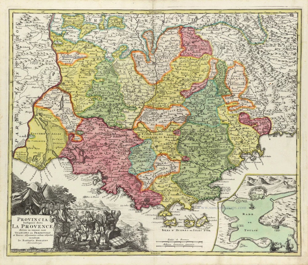
Provincia Indigenis dicta La Provence divisa in omnes suos Vicariatus seu Praefecturas et Terras adjacentes eidem subjectas c. 1720
Provence by J.B. Homann
[Item number: 32157]
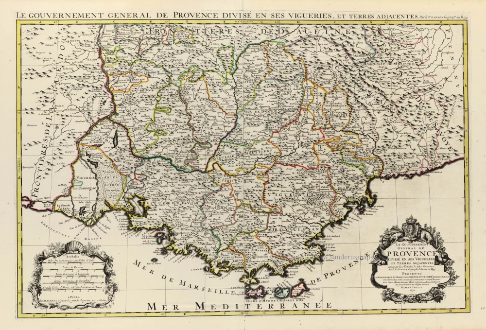
Le Gouvernement General de Provence divisé en ses Vigueries, et Terres Adjacentes. 1692
The Provence by Hubert Jaillot, after Nicolas Sanson.
[Item number: 32289]