
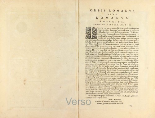
Parergon map
Roman Empire by Abraham Ortelius. 1603
The item displayed on this page has been sold. However, we have a similar map in stock:
Roman Empire by Abraham Ortelius. 1595
Romani Imperii Imago.
[Item number: 30641]
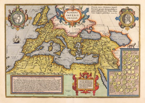
TRANSLATION OF CARTOUCHE TEXT (bottom left): "A shortlist of the origins, growth and culmination of the Roman Empire: At first, under the seven kings called Romulus, Servius, etc., the Roman Empire extended for 243 years no further than to Portus and Ostia within a radius of 18 miles. However, under the consuls, in some cases including dictators, groups of ten men, and military tribunes, Italy was conquered in 447 years beyond the river Po; Africa and Spain were subdued. Gallia and Britannia have been conquered; the Illyrians, Histrians, Liburnians and Dalmatians have been overrun; Greece has been invaded; the Macedonians have been beaten; wars have been waged against the Dardanians, the Moesians and the Thracians; the Danube has been reached, and the Romans have made their first conquests in Asia by winning Antiochus. When Mithridates had been defeated, they occupied the kingdom of Pontus and, simultaneously, the smaller province of Armenia under his rule. The Romans proceeded to Mesopotamia and struck a treaty with the Parths. They entered into combat with the Carduanians, Saracens and Arabs. They conquered all of Judea. They brought Cilicia and Syria under their rule. Finally, they invaded Egypt. However, when the emperors ruled, that is to say, from the time of divine Augustus until the time of Theodosius the Great and his sons Honorius and Arcadius, they brought under their rule in 440 years the Cantabrians, the Asturians, and all the rest of Spain. The Alps, Coccia and Rhaetia, Noricum, Pannonia and Moesia have augmented their power. The entire Danube area has been divided into provinces. Pontus, Greater Armenia, Assyria, Arabia, and Egypt came under Roman law. Thus, thanks to the exertions of their commanders, and through the courageous behaviour of the Roman population, and in immortal glory, they have attained the highest stage for this most elevated empire, of which the borders in the West are the ocean, in the North the Rhine and the Danube, in the East the Tigris, and in the South the Atlas mountain range. All this is shown on this map to benefit those studying history."
Text around the portrait of Tibullus: "Rome, your race is destined to rule the world."
CARTOUCHE bottom right: A genealogical tree of Roman kings.
CARTOUCHE bottom centre: "We have taken this genealogy of the seven kings from Livius, Dionysius and Plutarchus for those interested in Roman history. The main line of descent indicates the kings, the lesser lines their wives, and the smallest line their sons and daughters. Double circles indicate males, single circles females."
Abraham Ortelius (1527-1598)
The maker of the 'first atlas', the Theatrum Orbis Terrarum (1570), was born on 4 April 1527 into an old Antwerp family. He learned Latin and studied Greek and mathematics.
Abraham and his sisters Anne and Elizabeth took up map colouring. Ortelius was admitted to the Guild of St. Luke as an "illuminator of maps." In addition to colouring maps, Ortelius was a dealer in antiques, coins, maps, and books, and the book and map trade gradually became his primary occupation.
Business went well because his means permitted him to start an extensive collection of medals, coins, antiques, and a library of many volumes. In addition, he travelled a lot, visited Italy and France, made contacts everywhere with scholars and editors, and maintained extensive correspondence with them.
In 1564, he published his first map, a large and ambitious world wall map. The inspiration for this map may well have been Gastaldi's large world map. In 1565, he published a map of Egypt and a map of the Holy Land; a large map of Asia followed.
In 1568, the production of individual maps for his atlas Theatrum Orbis Terrarum was already in full swing. He completed the atlas in 1569, and in May 1570, it was available for sale. It was one of the most expensive books ever published.
This first edition contained seventy maps on fifty-three sheets. Franciscus Hogenberg engraved the maps.
Later editions included Additamenta (additions), resulting in Ortelius' historical atlas, the Parergon, which is mainly bound together with the atlas. The Parergon can be considered a truly original work by Ortelius, who drew the maps based on his research.
The importance of the Theatrum Orbis Terrarum for geographical knowledge in the last quarter of the sixteenth century is difficult to overemphasize. Nothing was like it until Mercator's atlas appeared twenty-five years later. Demand for the Theatrum was remarkable. Some 24 editions appeared during Ortelius's lifetime and another 10 after he died in 1598. Editions were published in Dutch, German, French, Spanish, English, and Italian. The number of map sheets grew from 53 in 1570 to 167 in 1612 in the last edition.
In 1577, engraver Philip Galle and poet-translator Pieter Heyns published the first pocket-sized edition of the Theatrum, the Epitome. The work was trendy. Over thirty editions of this Epitome were published in different languages.
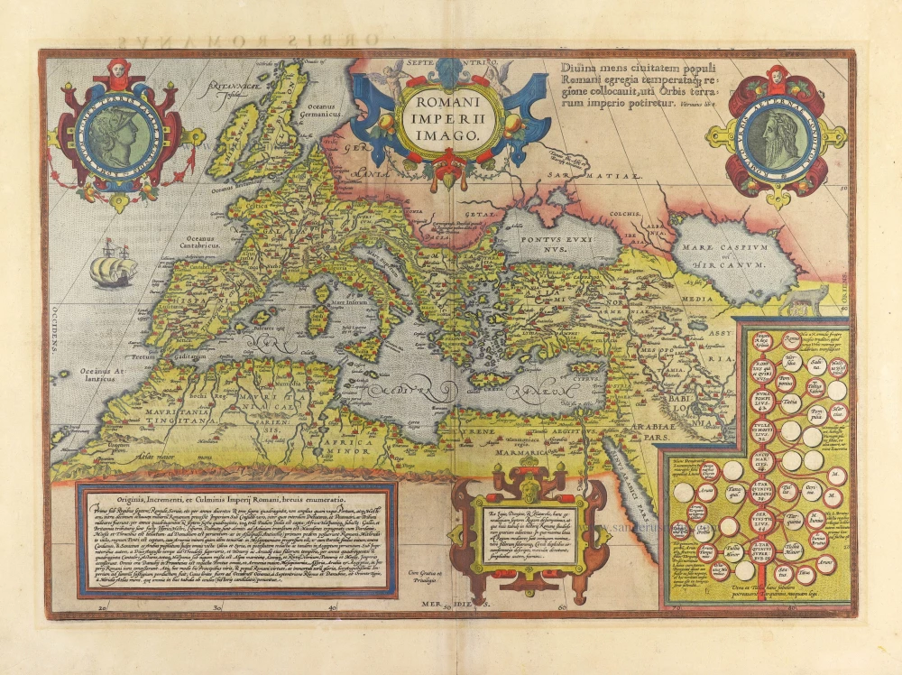
Romani Imperii Imago.
Item Number: 30178 Authenticity Guarantee
Category: Antique maps > Europe > Europe Continent
The Roman Empire by Abraham Ortelius.
Title: Romani Imperii Imago.
Cum Gratia et Privilegio.
Cartographer: Abraham Ortelius.
Date of the first edition: 1579.
Date of this map: 1595.
Copper engraving, printed on paper.
Map size: 350 x 500mm (13.78 x 19.69 inches).
Sheet size: 425 x 540mm (16.73 x 21.26 inches).
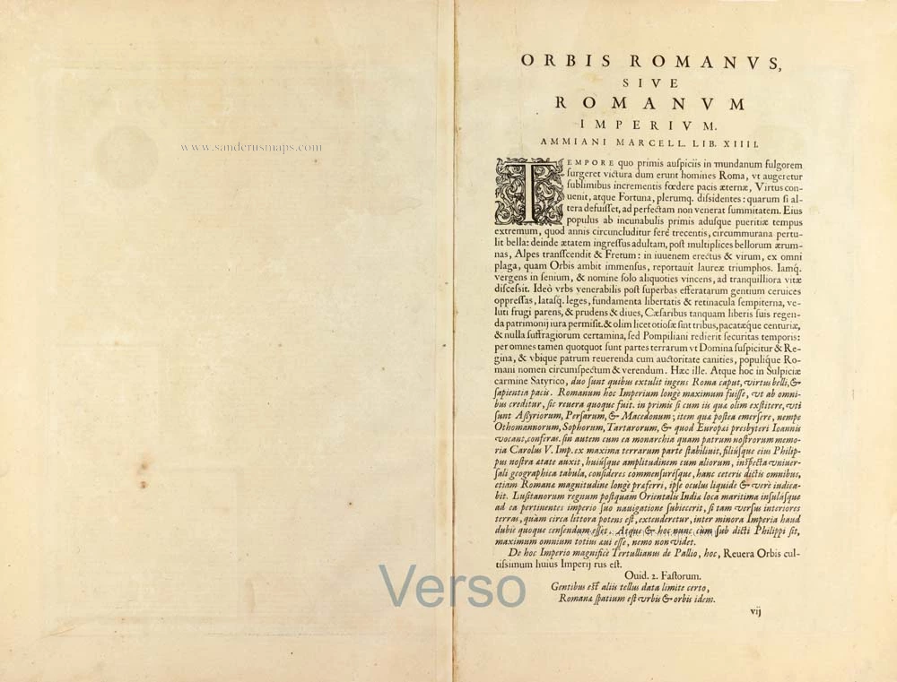
Verso: Latin text.
Condition: Hand coloured, excellent.
Condition Rating: A+.
From: Theatrum Orbis Terrarum. Antwerp, Plantin Press, 1595. (Van der Krogt 3, 31:051)
TRANSLATION OF CARTOUCHE TEXT (bottom left): "A shortlist of the origins, growth and culmination of the Roman Empire: At first, under the seven kings called Romulus, Servius, etc., the Roman Empire extended for 243 years no further than to Portus and Ostia within a radius of 18 miles. However, under the consuls, in some cases including dictators, groups of ten men, and military tribunes, Italy was conquered in 447 years beyond the river Po; Africa and Spain were subdued. Gallia and Britannia have been conquered; the Illyrians, Histrians, Liburnians and Dalmatians have been overrun; Greece has been invaded; the Macedonians have been beaten; wars have been waged against the Dardanians, the Moesians and the Thracians; the Danube has been reached, and the Romans have made their first conquests in Asia by winning Antiochus. When Mithridates had been defeated, they occupied the kingdom of Pontus and, simultaneously, the smaller province of Armenia under his rule. The Romans proceeded to Mesopotamia and struck a treaty with the Parths. They entered into combat with the Carduanians, Saracens and Arabs. They conquered all of Judea. They brought Cilicia and Syria under their rule. Finally, they invaded Egypt. However, when the emperors ruled, that is to say, from the time of divine Augustus until the time of Theodosius the Great and his sons Honorius and Arcadius, they brought under their rule in 440 years the Cantabrians, the Asturians, and all the rest of Spain. The Alps, Coccia and Rhaetia, Noricum, Pannonia and Moesia have augmented their power. The entire Danube area has been divided into provinces. Pontus, Greater Armenia, Assyria, Arabia, and Egypt came under Roman law. Thus, thanks to the exertions of their commanders, and through the courageous behaviour of the Roman population, and in immortal glory, they have attained the highest stage for this most elevated empire, of which the borders in the West are the ocean, in the North the Rhine and the Danube, in the East the Tigris, and in the South the Atlas mountain range. All this is shown on this map to benefit those studying history."
Text around the portrait of Tibullus: "Rome, your race is destined to rule the world."
CARTOUCHE bottom right: A genealogical tree of Roman kings.
CARTOUCHE bottom centre: "We have taken this genealogy of the seven kings from Livius, Dionysius and Plutarchus for those interested in Roman history. The main line of descent indicates the kings, the lesser lines their wives, and the smallest line their sons and daughters. Double circles indicate males, single circles females."
Abraham Ortelius (1527-1598)
The maker of the 'first atlas', the Theatrum Orbis Terrarum (1570), was born on 4 April 1527 into an old Antwerp family. He learned Latin and studied Greek and mathematics.
Abraham and his sisters Anne and Elizabeth took up map colouring. Ortelius was admitted to the Guild of St. Luke as an "illuminator of maps." In addition to colouring maps, Ortelius was a dealer in antiques, coins, maps, and books, and the book and map trade gradually became his primary occupation.
Business went well because his means permitted him to start an extensive collection of medals, coins, antiques, and a library of many volumes. In addition, he travelled a lot, visited Italy and France, made contacts everywhere with scholars and editors, and maintained extensive correspondence with them.
In 1564, he published his first map, a large and ambitious world wall map. The inspiration for this map may well have been Gastaldi's large world map. In 1565, he published a map of Egypt and a map of the Holy Land; a large map of Asia followed.
In 1568, the production of individual maps for his atlas Theatrum Orbis Terrarum was already in full swing. He completed the atlas in 1569, and in May 1570, it was available for sale. It was one of the most expensive books ever published.
This first edition contained seventy maps on fifty-three sheets. Franciscus Hogenberg engraved the maps.
Later editions included Additamenta (additions), resulting in Ortelius' historical atlas, the Parergon, which is mainly bound together with the atlas. The Parergon can be considered a truly original work by Ortelius, who drew the maps based on his research.
The importance of the Theatrum Orbis Terrarum for geographical knowledge in the last quarter of the sixteenth century is difficult to overemphasize. Nothing was like it until Mercator's atlas appeared twenty-five years later. Demand for the Theatrum was remarkable. Some 24 editions appeared during Ortelius's lifetime and another 10 after he died in 1598. Editions were published in Dutch, German, French, Spanish, English, and Italian. The number of map sheets grew from 53 in 1570 to 167 in 1612 in the last edition.
In 1577, engraver Philip Galle and poet-translator Pieter Heyns published the first pocket-sized edition of the Theatrum, the Epitome. The work was trendy. Over thirty editions of this Epitome were published in different languages.
Related items
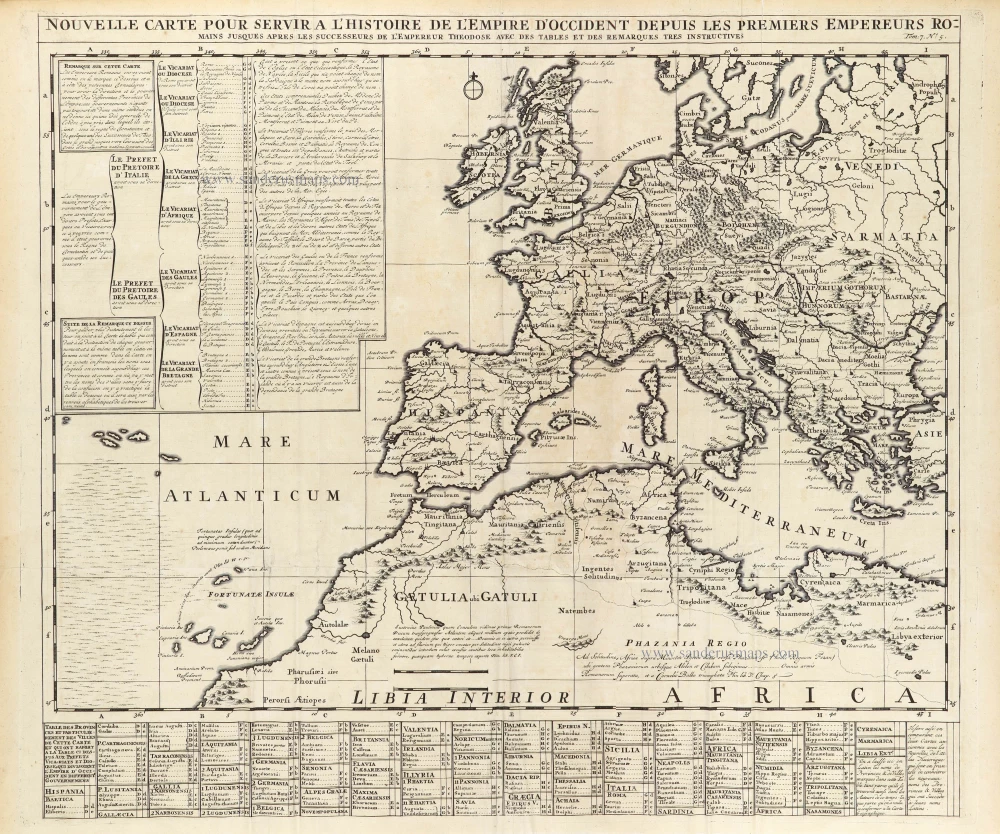
Nouvelle Carte pour servir à L'Histoire de L'Empire D'Occident depuis les premiers Empereurs Romains jusques après les successeurs de l'Empereur Theodose avex des tables et des remarques tres instructives. 1720
Western Roman Empire, by Zacharias Châtelain.
[Item number: 29357]

Nouvelle Carte pour servir à L'Histoire de L'Empire D'Orient depuis les premiers Empereurs Romains jusques après les successeurs de l'Empereur Theodose avec des tables et des remarques tres instructives. 1720
Eastern Roman Empire, by Zacharias Châtelain.
[Item number: 29358]
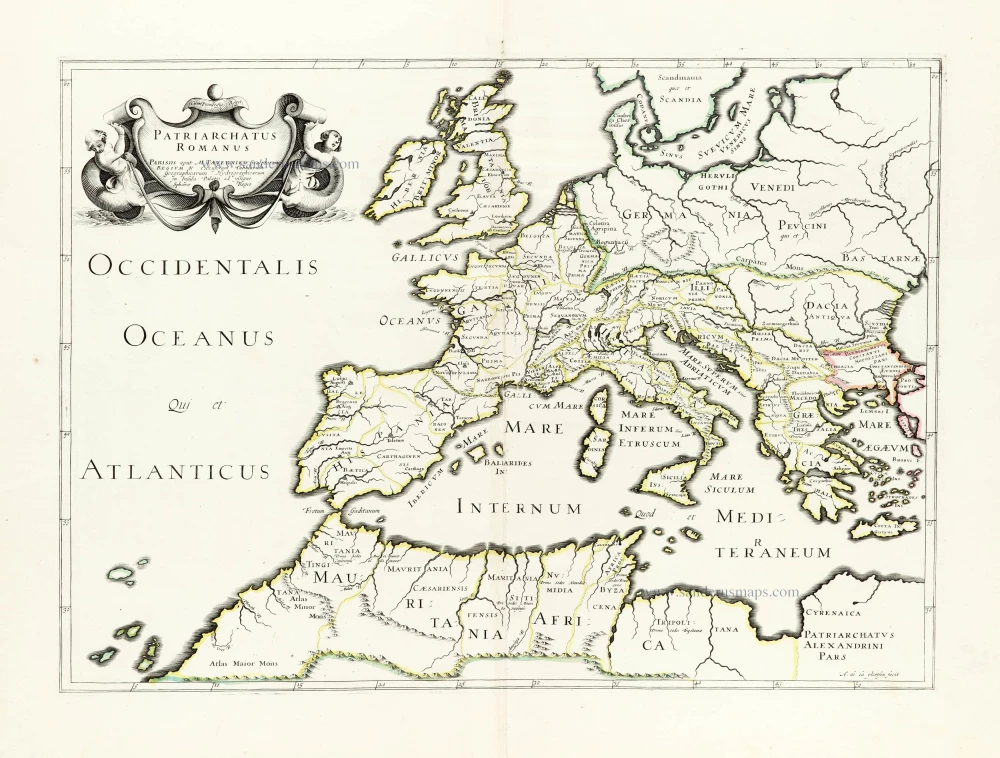
Patriarchatus Romanus c. 1632
Roman Empire in Europe, published by Melchior Tavernier.
[Item number: 30118]