
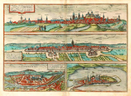
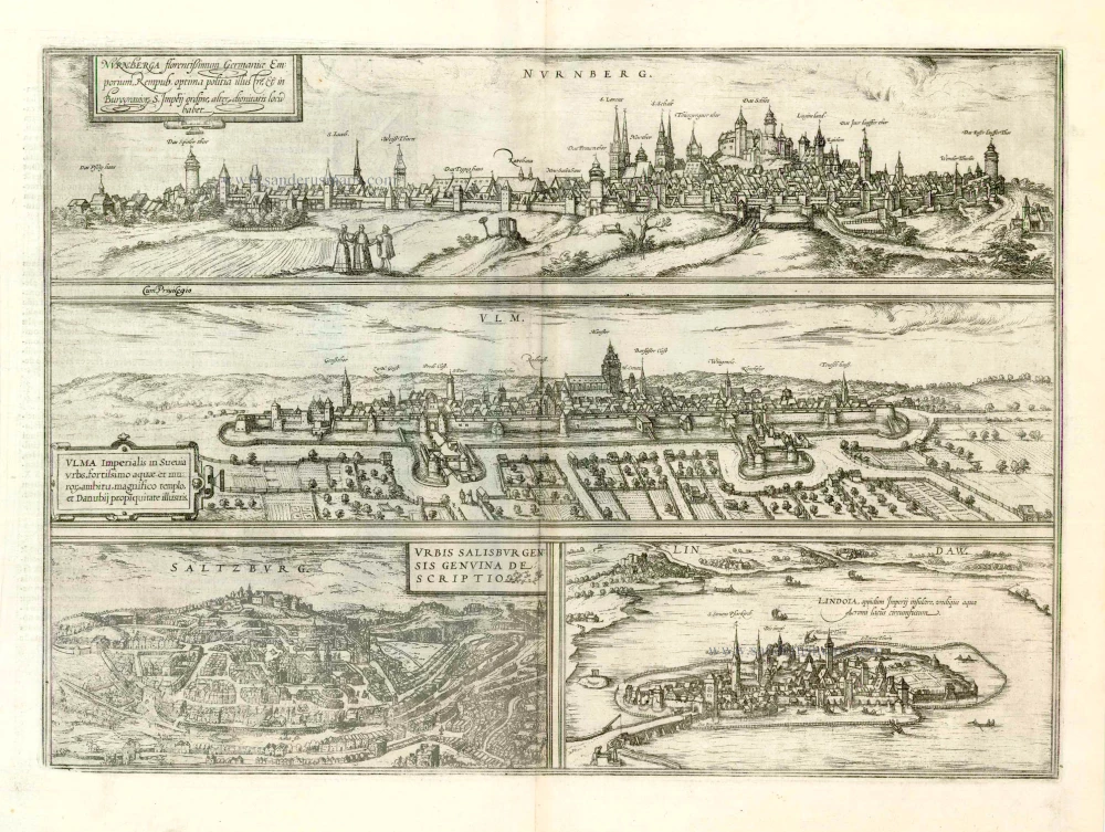
Nürnberg, Ulm, Salzburg, and Lindau by Georg Braun & Frans Hogenberg. 1572
The item displayed on this page has been sold. However, we have a similar map in stock:
Nürnberg - Ulm - Salzburg - Lindau by Braun & Hogenberg 1572-1624
Nurnberga Florentissimum Germaniae Emporium, ......
[Item number: 23336]
![Nurnberga Florentissimum Germaniae Emporium, ... [on sheet with] Ulma Imperialis in Suevia [and] Saltzburg Urbis Salisburgensis Genvina Descriptio [and] Lindaw - Lindoia, Oppidum Imperij insulare, ...](https://sanderusmaps.com/assets/RESIZED/thumb_m23336.jpg)

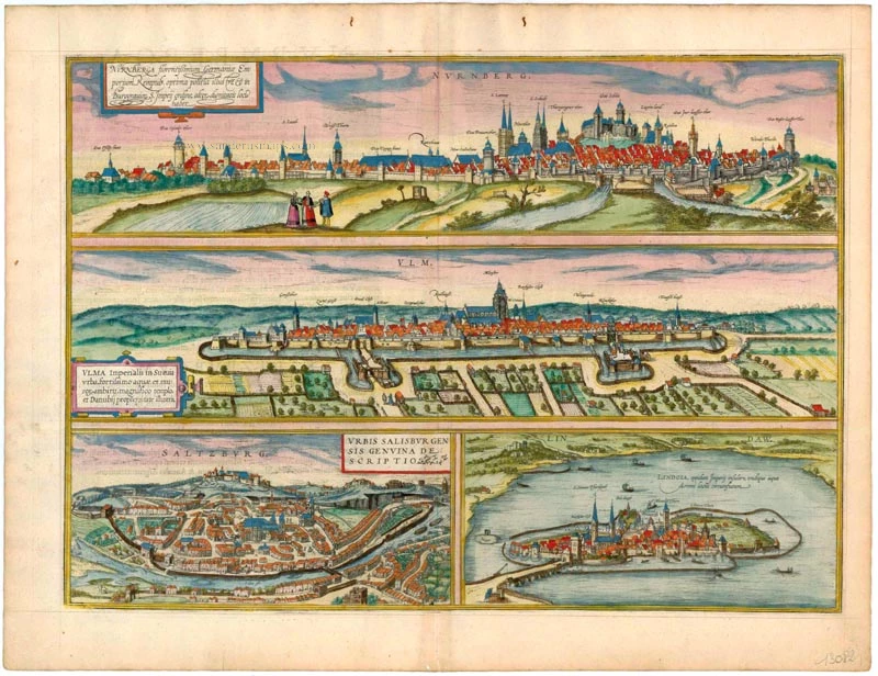


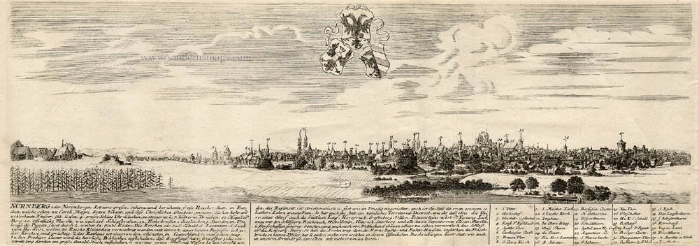
NUREMBERG (NÜRNBERG)
TRANSLATION OF CARTOUCHE TEXT: Nuremberg is a flourishing German trade city, widely famed for its excellent civic constitution, within the order of rank of burgraves in the Holy Empire, it occupies second place.
COMMENTARY BY BRAUN: "Nuremberg is highly famed in all Germany and Europe as an important trade city and is embellished with splendid public and private houses. Nuremberg possesses a very old royal fortress on a hill in the middle of the city: from there one has a view of the city and far beyond it. Nuremberg is thought to have taken its name from this fortress, which in old books is called Nordgauburg or Nordburg [...]. Many astute craftsmen and prudent merchants, very many fine and creative inventors and masters, live there."
Source: Hartmann Schedel, Nuremberg Chronicle, 1493. The way the city of Nuremberg is perceived has been shaped by the showy double-sided view in Hartmann Schedel's 1493 Chronicle. Schedel presented an ideal picture of a city well fortified with a double ring wall, full of beautifully ordered patrician houses and boasting the church of St Sebald and the church of St Lawrence. The high point of all this glorious urbanity in Schedel is definitely the imperial castle looming high above the city. In his text, Braun lays emphasis on the castle, which afforded superb views. The two pictures in Braun-Hogenberg, however, are not dominated by the steeply rising fortress; indeed the differences in elevation within the city have been considerably levelled off.
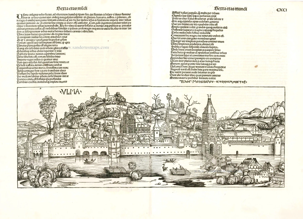
ULM
CARTOUCHE: Ulm, imperial city in Swabia, famed for strong walls and moats, its magnificent church and the nearby Danube.
COMMENTARY BY BRAUN: "Ulm is a splendid city in Swabia on the north bank of the Danube at its junction with the Iller and the Blau, whose additional waters make the Danube navigable. In this city there is a parish church that was built for the lofty sum of 900,000 gold guilders. The inhabitants live partly from commerce and partly from crafts. A special cloth made of linen, cotton and yarn is manufactured here, which they call fustian."
The view from Michelsberg hill shows Ulm well protected by high walls and its riverside location. The major landmarks are clearly captioned: Ulm's famous cathedral (Munster) - the largest parish church in Germany - and the Gothic town hall (Radhauss) slightly in front of it to the left can be easily identified, as can the smaller monasteries and the formidable city gates. Ulm reached its chief industries, but it also conducted a flourishing trade in iron, wine and wood. The city was also famous for its artists and craftsmen and for book printing.
The view is made after an etching by Georg Rieder the Younger, 1570.
SALZBURG
CARTOUCHE: Faithful illustration of the city of Salzburg.
COMMENTARY BY BRAUN: "Salzbourg is surrounded by lakes, plains, hills and mountains. The lakes provide fertile meadows, the mountains fowling and hunting [...]. Franciscus Irenicus ranks Salzburg in first place amongst the five bishoprics of Bavaria and expressly praises this episcopal city, which Enea Silvio Piccolimini even calls a capital."
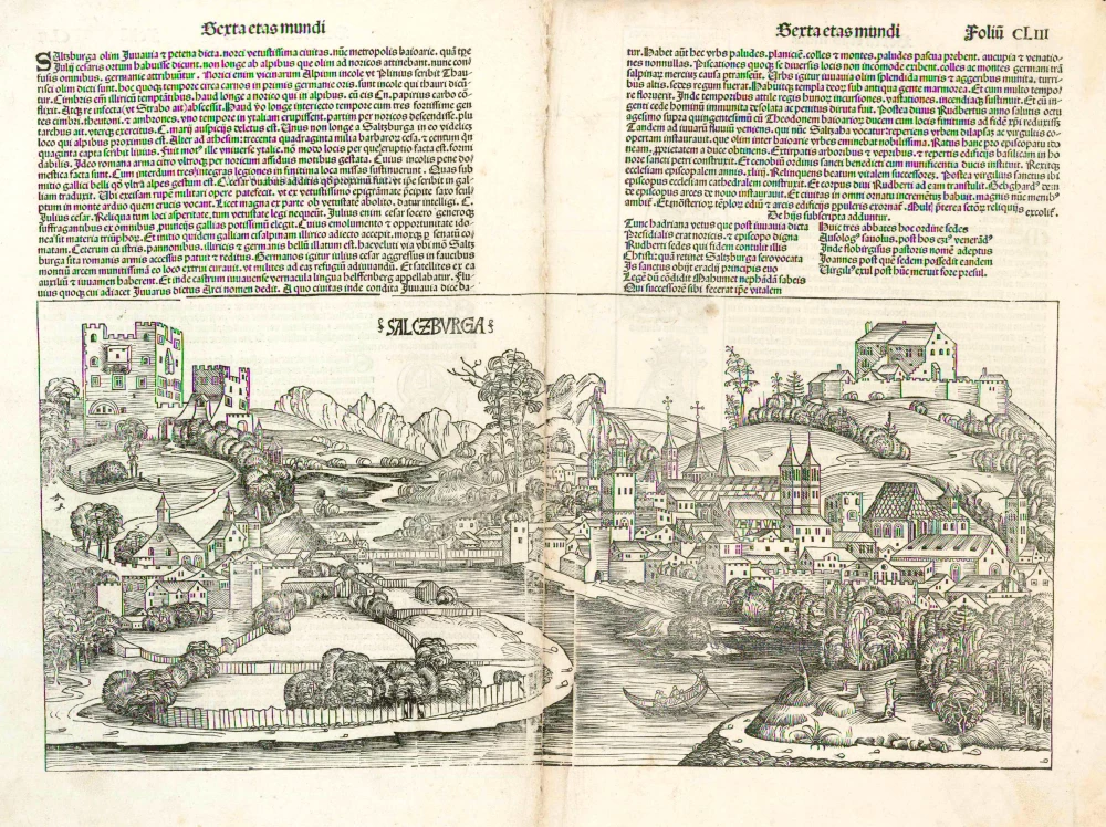
This is a highly schematic view of Salzburg from on top of Kapuzinerberg. The 11th-century fortress of Hohensalzburg, the largest castle complex in Europe, is easily recognizable in its dominant position above the city, whereas the buildings below are condensed into narrow blocks in favour of wide streets and squares. The impression of spaciousness does not correspond to the actual appearance of the city wedged between the Mönchsberg and the Kapuzinerberg. Braun refers to the legendary history of Salzburg, according to which it was founded by Julius Caesar. Salzburg is first mentioned in records in AD 755 as a trading settlement; in 996 it was granted the right to hold a market and mint its own coins; and in 1287 it received its municipal charter. From the 16th century onwards Salzburg played an important role as a city of trade and as the residence of the prince-archbishops. Following a devastating fire in 1598, Archbishop Wolf Dietrich of Raitenau had 55 town houses demolished in order to make space for a new cathedral and a grander street plan. The new cathedral in the Baroque style continues to leave its stamp on the face of Salzburg even today.
The view is made after a drawing by an unknown artist, 1553, which was used both for the woodcut in Münster's Cosmographia and the map of Austria in Ortelius's Theatrum orbis terrarum.
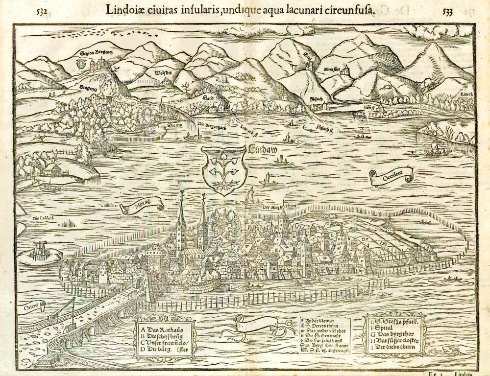
LINDAU
CAPTION: Lindau, imperial city on an island, surrounded all around by the waters of Lake Constance.
COMMENTARY BY BRAUN: "Lindau is an imperial city that lies below Bregenz on Lake Constance, and which is surrounded by water like an island and is connected to the mainland only by a masonry bridge of 290 paces. [...] To the west lies a large and wide field that in normal years can produce some 100 tuns of wine."
A number of Lindau's historic sights are clearly recognizable in the engraving. On the left is St Stephen's church, begun in the 12th century and frequently altered, and on the right, as part of the city defences, the "Thieves' tower" (Diebsturm) of 1380 with its four overhanging turrets. Directly to its left is St Peter's, Lindau's oldest church, which dates from the 12th century and contains valuable frecoes by Hans Holbein the Elder. Lindau goes back to a nunnery first mentioned in records in AD 822. The town was granted its charter before 1216 and from c. 1300 to 1803 was an imperial city.
The view is made after a woodcut by Jakob Clauser in Münster's Cosmographia, 1550.
Braun G. & Hogenberg F. and the Civitates Orbis Terrarum.
The Civitates Orbis Terrarum, also known as the 'Braun & Hogenberg', is a six-volume town atlas and the most excellent book of town views and plans ever published: 363 engravings, sometimes beautifully coloured. It was one of the best-selling works in the last quarter of the 16th century. Georg Braun, a skilled writer, wrote the text accompanying the plans and views on the verso. Many plates were engraved after the original drawings of a professional artist, Joris Hoefnagel (1542-1600). The first volume was published in Latin in 1572 and the sixth in 1617. Frans Hogenberg, a talented engraver, created the tables for volumes I through IV, and Simon van den Neuwel made those for volumes V and VI. Other contributors were cartographers Daniel Freese and Heinrich Rantzau, who provided valuable geographical information. Works by Jacob van Deventer, Sebastian Münster, and Johannes Stumpf were also used as references. Translations appeared in German and French, making the atlas accessible to a broader audience.
Since its original publication of volume 1 in 1572, the Civitates Orbis Terrarum has left an indelible mark on the history of cartography. Seven more editions followed the first volume in 1575, 1577, 1582, 1588, 1593, 1599, and 1612. Vol.2, initially released in 1575, saw subsequent editions in 1597 and 1612. The subsequent volumes, each a treasure trove of historical insights, graced the world in 1581, 1588, 1593, 1599, and 1606. The German translation of the first volume, a testament to its widespread appeal, debuted in 1574, followed by the French edition in 1575.
Several printers were involved: Theodor Graminaeus, Heinrich von Aich, Gottfried von Kempen, Johannis Sinniger, Bertram Buchholtz, and Peter von Brachel, all of whom worked in Cologne.
Georg Braun (1541-1622)
Georg Braun, the author of the text accompanying the plans and views in the Civitates Orbis Terrarum, was born in Cologne in 1541. After his studies in Cologne, he entered the Jesuit Order as a novice, indicating his commitment to learning and intellectual pursuits. In 1561, he obtained his bachelor's degree; in 1562, he received his Magister Artium, further demonstrating his academic achievements. Although he left the Jesuit Order, he continued his studies in theology, gaining a licentiate in theology. His theological background likely influenced the content and tone of the text in the Civitates Orbis Terrarum, adding a unique perspective to the work.
Frans Hogenberg (1535-1590)
Frans Hogenberg was a Flemish and German painter, engraver, and mapmaker. He was born in Mechelen as the son of Nicolaas Hogenberg.
By the end of the 1560s, Frans Hogenberg was employed upon Abraham Ortelius's Theatrum Orbis Terrarum, published in 1570; he is named an engraver of numerous maps. In 1568, he was banned from Antwerp by the Duke of Alva and travelled to London, where he stayed a few years before emigrating to Cologne. He immediately embarked on his two most important works, the Civitates, published in 1572 and the Geschichtsblätter, which appeared in several series from 1569 until about 1587.
Thanks to large-scale projects like the Geschichtsblätter and the Civitates, Hogenberg's social circumstances improved with each passing year. He died as a wealthy man in Cologne in 1590.
Nurnberga Florentissimum Germaniae Emporium, ... [on sheet with] Ulma Imperialis in Suevia [and] Saltzburg Urbis Salisburgensis Genvina Descriptio [and] Lindaw - Lindoia, Oppidum Imperij insulare, ...
Item Number: 13082 Authenticity Guarantee
Category: Antique maps > Europe > Germany - Cities
Four bird's-eye views on one sheet: Nürnberg, Ulm, Salzburg and Lindau by Georg Braun & Frans Hogenberg.
Title: Nurnberga Florentissimum Germaniae Emporium, ... [on sheet with] Ulma Imperialis in Suevia [and] Saltzburg Urbis Salisburgensis Genvina Descriptio [and] Lindaw - Lindoia, Oppidum Imperij insulare, ...
Date of the first edition: 1572.
Date of this map: 1572.
Copper engraving, printed on paper.
Map size: 335 x 470mm (13.19 x 18.5 inches).
Sheet size: 405 x 525mm (15.94 x 20.67 inches).
Verso: Latin text.
Condition: Superb old colour, light browning along centrefold.
Condition Rating: A+
References: Van der Krogt 4, 3136 (First plate), State 1; Taschen, Braun and Hogenberg, p.90
From: Civitates Orbis Terrarum, Liber Primus. Cologne, Theodor Graminaeus, 1572.. (Van der Krogt 4, 41:0)
NUREMBERG (NÜRNBERG)
TRANSLATION OF CARTOUCHE TEXT: Nuremberg is a flourishing German trade city, widely famed for its excellent civic constitution, within the order of rank of burgraves in the Holy Empire, it occupies second place.
COMMENTARY BY BRAUN: "Nuremberg is highly famed in all Germany and Europe as an important trade city and is embellished with splendid public and private houses. Nuremberg possesses a very old royal fortress on a hill in the middle of the city: from there one has a view of the city and far beyond it. Nuremberg is thought to have taken its name from this fortress, which in old books is called Nordgauburg or Nordburg [...]. Many astute craftsmen and prudent merchants, very many fine and creative inventors and masters, live there."
Source: Hartmann Schedel, Nuremberg Chronicle, 1493. The way the city of Nuremberg is perceived has been shaped by the showy double-sided view in Hartmann Schedel's 1493 Chronicle. Schedel presented an ideal picture of a city well fortified with a double ring wall, full of beautifully ordered patrician houses and boasting the church of St Sebald and the church of St Lawrence. The high point of all this glorious urbanity in Schedel is definitely the imperial castle looming high above the city. In his text, Braun lays emphasis on the castle, which afforded superb views. The two pictures in Braun-Hogenberg, however, are not dominated by the steeply rising fortress; indeed the differences in elevation within the city have been considerably levelled off.
ULM
CARTOUCHE: Ulm, imperial city in Swabia, famed for strong walls and moats, its magnificent church and the nearby Danube.
COMMENTARY BY BRAUN: "Ulm is a splendid city in Swabia on the north bank of the Danube at its junction with the Iller and the Blau, whose additional waters make the Danube navigable. In this city there is a parish church that was built for the lofty sum of 900,000 gold guilders. The inhabitants live partly from commerce and partly from crafts. A special cloth made of linen, cotton and yarn is manufactured here, which they call fustian."
The view from Michelsberg hill shows Ulm well protected by high walls and its riverside location. The major landmarks are clearly captioned: Ulm's famous cathedral (Munster) - the largest parish church in Germany - and the Gothic town hall (Radhauss) slightly in front of it to the left can be easily identified, as can the smaller monasteries and the formidable city gates. Ulm reached its chief industries, but it also conducted a flourishing trade in iron, wine and wood. The city was also famous for its artists and craftsmen and for book printing.
The view is made after an etching by Georg Rieder the Younger, 1570.
SALZBURG
CARTOUCHE: Faithful illustration of the city of Salzburg.
COMMENTARY BY BRAUN: "Salzbourg is surrounded by lakes, plains, hills and mountains. The lakes provide fertile meadows, the mountains fowling and hunting [...]. Franciscus Irenicus ranks Salzburg in first place amongst the five bishoprics of Bavaria and expressly praises this episcopal city, which Enea Silvio Piccolimini even calls a capital."
This is a highly schematic view of Salzburg from on top of Kapuzinerberg. The 11th-century fortress of Hohensalzburg, the largest castle complex in Europe, is easily recognizable in its dominant position above the city, whereas the buildings below are condensed into narrow blocks in favour of wide streets and squares. The impression of spaciousness does not correspond to the actual appearance of the city wedged between the Mönchsberg and the Kapuzinerberg. Braun refers to the legendary history of Salzburg, according to which it was founded by Julius Caesar. Salzburg is first mentioned in records in AD 755 as a trading settlement; in 996 it was granted the right to hold a market and mint its own coins; and in 1287 it received its municipal charter. From the 16th century onwards Salzburg played an important role as a city of trade and as the residence of the prince-archbishops. Following a devastating fire in 1598, Archbishop Wolf Dietrich of Raitenau had 55 town houses demolished in order to make space for a new cathedral and a grander street plan. The new cathedral in the Baroque style continues to leave its stamp on the face of Salzburg even today.
The view is made after a drawing by an unknown artist, 1553, which was used both for the woodcut in Münster's Cosmographia and the map of Austria in Ortelius's Theatrum orbis terrarum.
LINDAU
CAPTION: Lindau, imperial city on an island, surrounded all around by the waters of Lake Constance.
COMMENTARY BY BRAUN: "Lindau is an imperial city that lies below Bregenz on Lake Constance, and which is surrounded by water like an island and is connected to the mainland only by a masonry bridge of 290 paces. [...] To the west lies a large and wide field that in normal years can produce some 100 tuns of wine."
A number of Lindau's historic sights are clearly recognizable in the engraving. On the left is St Stephen's church, begun in the 12th century and frequently altered, and on the right, as part of the city defences, the "Thieves' tower" (Diebsturm) of 1380 with its four overhanging turrets. Directly to its left is St Peter's, Lindau's oldest church, which dates from the 12th century and contains valuable frecoes by Hans Holbein the Elder. Lindau goes back to a nunnery first mentioned in records in AD 822. The town was granted its charter before 1216 and from c. 1300 to 1803 was an imperial city.
The view is made after a woodcut by Jakob Clauser in Münster's Cosmographia, 1550.
Braun G. & Hogenberg F. and the Civitates Orbis Terrarum.
The Civitates Orbis Terrarum, also known as the 'Braun & Hogenberg', is a six-volume town atlas and the most excellent book of town views and plans ever published: 363 engravings, sometimes beautifully coloured. It was one of the best-selling works in the last quarter of the 16th century. Georg Braun, a skilled writer, wrote the text accompanying the plans and views on the verso. Many plates were engraved after the original drawings of a professional artist, Joris Hoefnagel (1542-1600). The first volume was published in Latin in 1572 and the sixth in 1617. Frans Hogenberg, a talented engraver, created the tables for volumes I through IV, and Simon van den Neuwel made those for volumes V and VI. Other contributors were cartographers Daniel Freese and Heinrich Rantzau, who provided valuable geographical information. Works by Jacob van Deventer, Sebastian Münster, and Johannes Stumpf were also used as references. Translations appeared in German and French, making the atlas accessible to a broader audience.
Since its original publication of volume 1 in 1572, the Civitates Orbis Terrarum has left an indelible mark on the history of cartography. Seven more editions followed the first volume in 1575, 1577, 1582, 1588, 1593, 1599, and 1612. Vol.2, initially released in 1575, saw subsequent editions in 1597 and 1612. The subsequent volumes, each a treasure trove of historical insights, graced the world in 1581, 1588, 1593, 1599, and 1606. The German translation of the first volume, a testament to its widespread appeal, debuted in 1574, followed by the French edition in 1575.
Several printers were involved: Theodor Graminaeus, Heinrich von Aich, Gottfried von Kempen, Johannis Sinniger, Bertram Buchholtz, and Peter von Brachel, all of whom worked in Cologne.
Georg Braun (1541-1622)
Georg Braun, the author of the text accompanying the plans and views in the Civitates Orbis Terrarum, was born in Cologne in 1541. After his studies in Cologne, he entered the Jesuit Order as a novice, indicating his commitment to learning and intellectual pursuits. In 1561, he obtained his bachelor's degree; in 1562, he received his Magister Artium, further demonstrating his academic achievements. Although he left the Jesuit Order, he continued his studies in theology, gaining a licentiate in theology. His theological background likely influenced the content and tone of the text in the Civitates Orbis Terrarum, adding a unique perspective to the work.
Frans Hogenberg (1535-1590)
Frans Hogenberg was a Flemish and German painter, engraver, and mapmaker. He was born in Mechelen as the son of Nicolaas Hogenberg.
By the end of the 1560s, Frans Hogenberg was employed upon Abraham Ortelius's Theatrum Orbis Terrarum, published in 1570; he is named an engraver of numerous maps. In 1568, he was banned from Antwerp by the Duke of Alva and travelled to London, where he stayed a few years before emigrating to Cologne. He immediately embarked on his two most important works, the Civitates, published in 1572 and the Geschichtsblätter, which appeared in several series from 1569 until about 1587.
Thanks to large-scale projects like the Geschichtsblätter and the Civitates, Hogenberg's social circumstances improved with each passing year. He died as a wealthy man in Cologne in 1590.
Related items
Salczburga 1493
Salzburg, by Hartmann Schedel.
[Item number: 5307]

ULMA 1493
Ulm, by Hartmann Schedel.
[Item number: 10102]
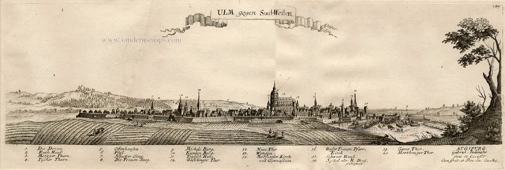
Ulm gegen Sud-Westen 1720
Ulm, by Bodenehr G.
[Item number: 13405]
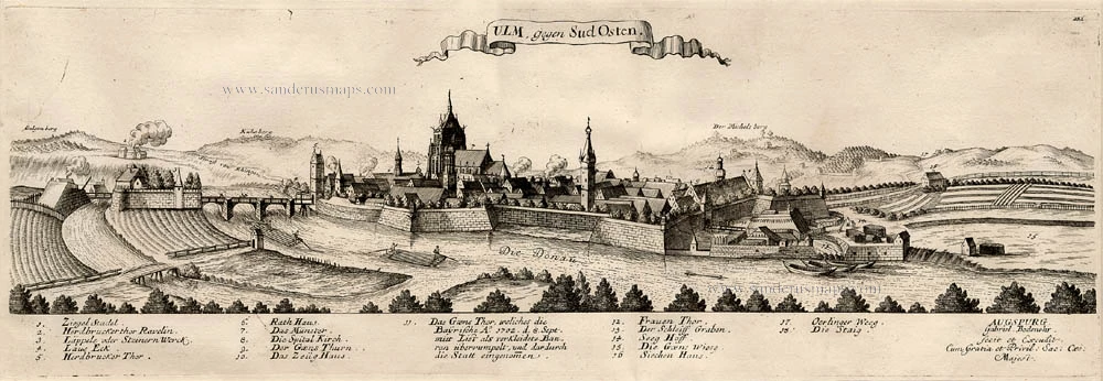
Ulm gegen Sud Osten 1720
Ulm, by Bodenehr G.
[Item number: 13406]
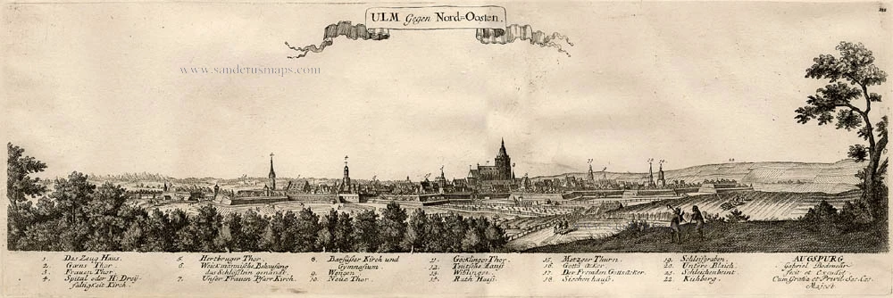
Ulm gegen Nord-Oosten 1720
Ulm, by Bodenehr G.
[Item number: 13407]
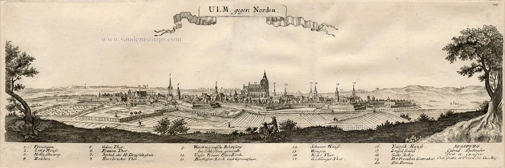
UlM gegen Norden c.1716
Ulm, by Bodenehr G.
[Item number: 13408]
Nürnberg c.1716
Nürnberg by Bodenehr G.
[Item number: 13417]
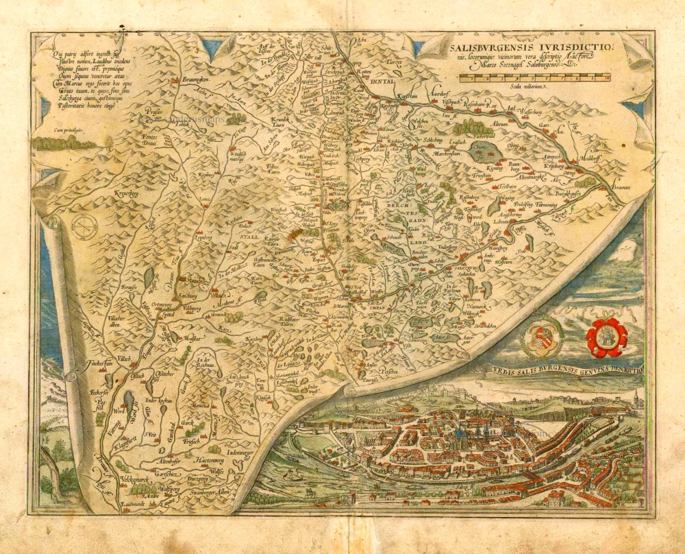
Salisburgensis Iurisdictionis, locorumque vicinorum vera descriptio. 1572
Austria, by Abraham Ortelius.
[Item number: 16002]
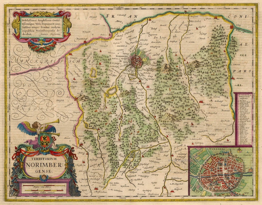
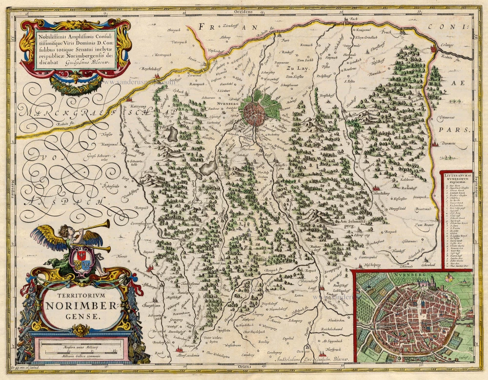
Territorium Norimbergense. 1645-58
Nürnberg by J. Janssonius
[Item number: 18671]
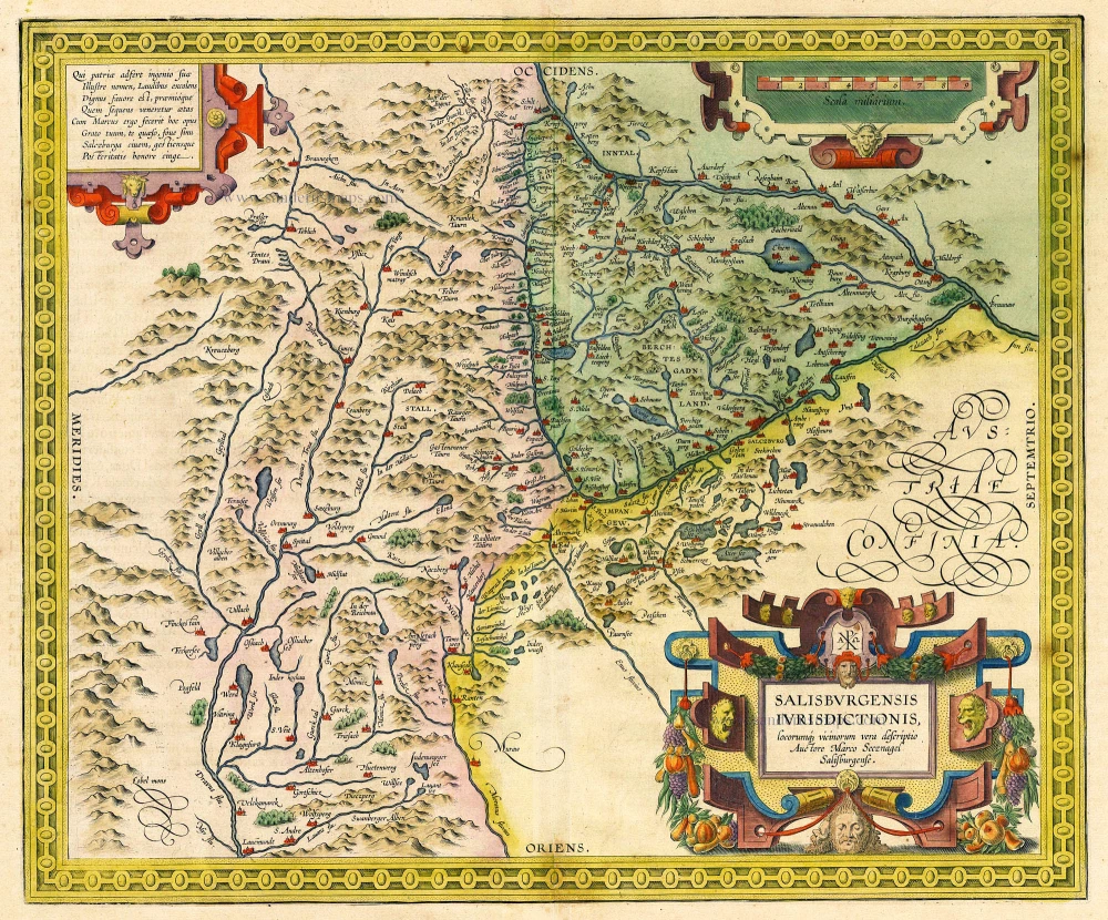
Salisburgensis Iurisdictionis, locorumq vicinorum vera descriptio. Auctore Marco Secznagel Salisburgense. 1612
Salzburg, by Ortelius A.
[Item number: 18677]
Territorium Norimbergense. 1647-50
Nürnberg, by Willem Blaeu.
[Item number: 18867]
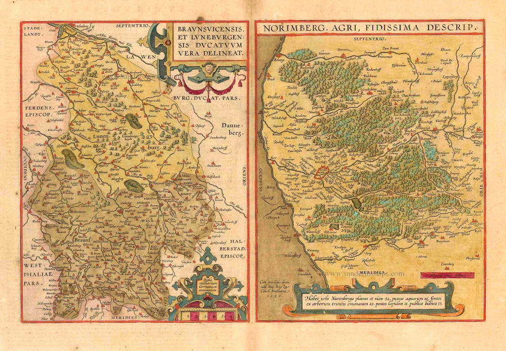
Braunsuicensis et Luneburgensis Ducatuum Vera Delineat [on sheet with:] Norimberg. Agri. Fidissima Descrip. 1612.
Braunschweig/Lüneburg & Nürnberg by Ortelius A.
[Item number: 22873]
Nurnberga Florentissimum Germaniae Emporium, ... [on sheet with] Ulma Imperialis in Suevia [and] Saltzburg Urbis Salisburgensis Genvina Descriptio [and] Lindaw - Lindoia, Oppidum Imperij insulare, ... 1599
Nürnberg, Ulm, Salzburg, and Lindau, by Georg Braun and Frans Hogenberg.
[Item number: 23926]
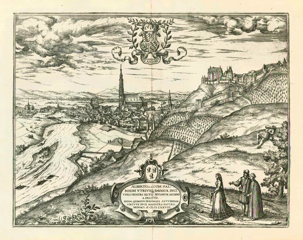
Landshut 1599
Landshut, by Georg Braun and Frans Hogenberg.
[Item number: 24060]
Ulma 1493
Ulm by Hartmann Schedel.
[Item number: 24393]

Nürnberg. 1658/60
Nürnberg, by Nicolaes Visscher & Pieter Hendricksz. Schut.
[Item number: 26651]
Lindoiae civitas insularis, undique aqua lacunaris circunfusa. 1552
Lindau, by Sebastian Münster.
[Item number: 26850]